You probably know the big names: the Grand Canyon, Yellowstone, maybe the Rockies. But scattered across North America are quieter, stranger places where the planet’s crust has done some truly weird things – and almost no one talks about them. If you love the feeling of standing somewhere and thinking, “How on earth is this even real?”, these are the spots that will get under your skin in the best way.
As you read, try to picture yourself there: feeling ancient lava under your boots, watching water vanish into the ground, or standing beside crystals taller than a house. These are not the usual postcard views, and that is exactly why they stick in your memory. By the time you reach the end, you might have a completely new North America in your head.
1. Naica’s Giant Crystal Cave, Mexico: A Hidden Cathedral of Selenite
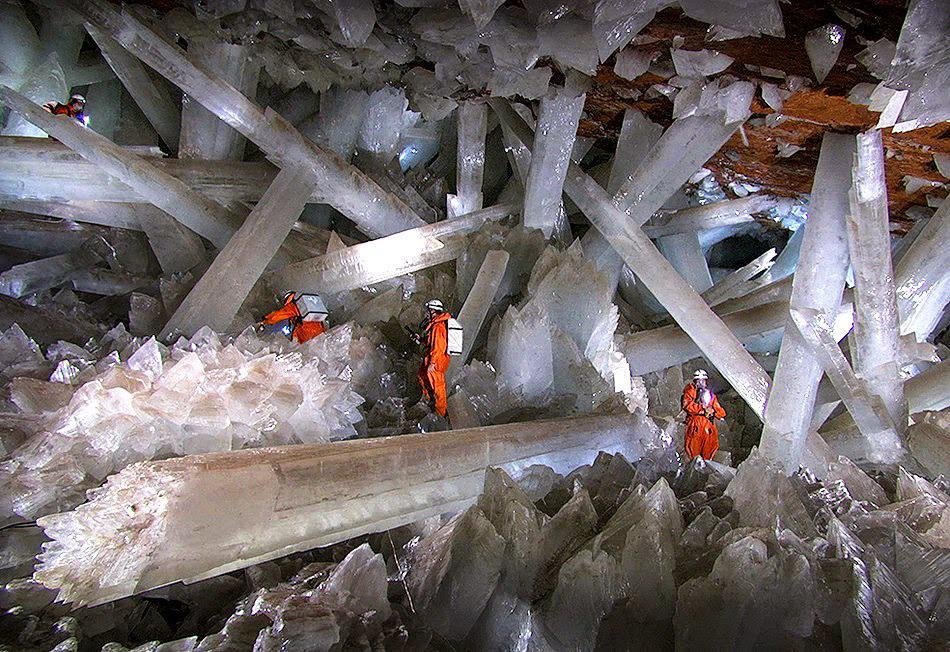
Imagine stepping into a room where the “pillars” are clear crystals the size of buses and the air feels like a sauna turned up too high. That is what you walk into at the Giant Crystal Cave near Naica, in northern Mexico – a chamber roughly a thousand feet below the surface filled with some of the largest known crystals on Earth. These enormous selenite blades grew slowly in hot, mineral-rich groundwater that stayed at a nearly constant temperature for hundreds of thousands of years, giving each crystal time to reach astonishing lengths of more than thirty feet and weights measured in tens of tons.
Because the cave is so hot and humid, you cannot just wander in with a flashlight and a bottle of water; scientists who study it need special cooling suits and carefully timed visits. For you, this place is more of a thought experiment than an easy stop on a road trip, but that might be part of its pull. Just knowing that a natural crystal cathedral exists below an ordinary-looking mining town changes how you think about what could be hidden beneath your feet anywhere you stand in North America.
2. The Driftless Area, Upper Midwest: The Place the Ice Forgot
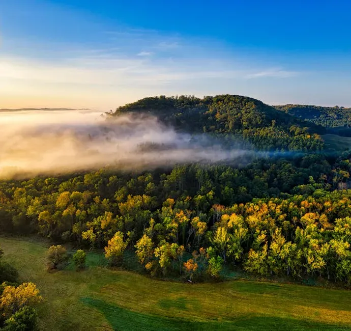
When you picture the Midwest, you probably think of endless flat fields, not deep valleys, cold-air talus slopes, and spring-fed trout streams twisting between steep wooded hills. Yet in parts of southwestern Wisconsin and neighboring states, you walk into a landscape nicknamed the Driftless Area because the last major ice sheets simply never covered it. While glaciers scraped and flattened much of the continent, this pocket stayed ice-free, keeping its older river-carved topography intact like a geological time capsule.
As you drive or hike there, you notice that the valleys feel outsized compared with the small streams that run through them, a sign that much larger rivers once did the work. In some spots, broken rock piles called algific talus slopes leak cold air from underground ice, creating miniature climate zones where rare plants and even certain snails cling on through hot summers. If you want to feel how profoundly ice ages shaped North America – and what a place looks like when the ice passes it by – you will sense that here immediately, even if you did not know the term “glacial drift” before you arrived.
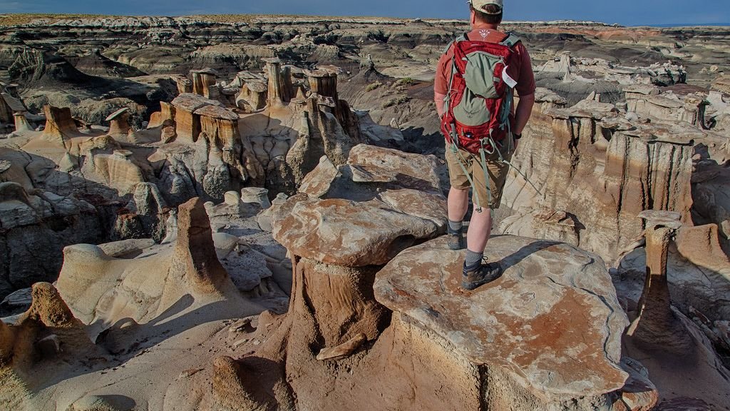
3. Bisti/De-Na-Zin Badlands, New Mexico: Walking Through a Fossilized Sci‑Fi World
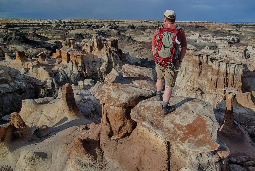
Stand in the Bisti/De‑Na‑Zin Wilderness in northwestern New Mexico and you could swear you have stumbled onto the set of a science fiction film. Around you, slender hoodoos balance wider stones on top like helmets, petrified logs rest half-buried in gray ash, and eroded clay hills glow in soft shades of white, purple, and rust. Long ago, this was a low, swampy coastal plain on the edge of a vast inland sea, where trees fell and were buried in sediment, dinosaurs roamed, and volcanic ash rained down from far-away eruptions.
Over tens of millions of years, that soft material hardened into rock and then started to erode in today’s dry climate, leaving behind strange sculpted shapes that look almost deliberate. When you hike there now, you are essentially walking through the peeled-back layers of a vanished world, with every ridge and hoodoo shaped by the balance between harder caprock and softer layers underneath. It is quiet, remote, and almost eerily empty, so you feel the scale of time pressing in on you with every step, far away from the crowds at more famous parks.
4. Goblin Valley, Utah: Thousands of Stone “Creatures” in a Desert Bowl
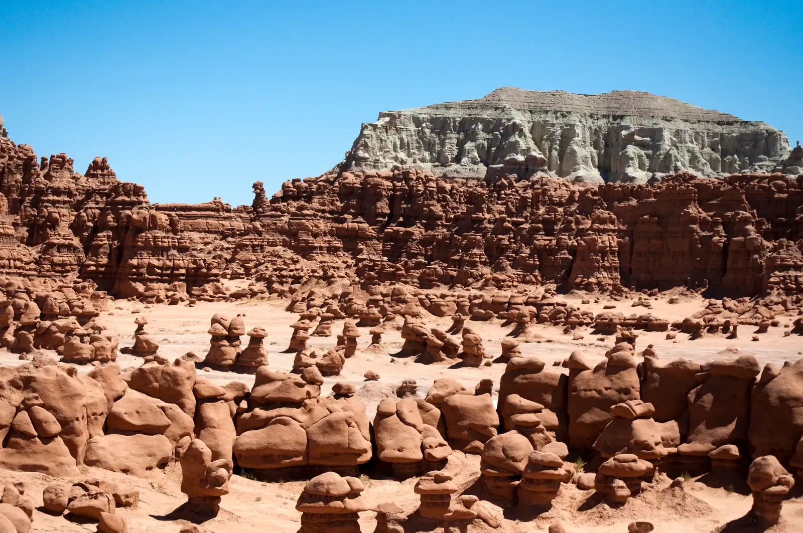
If you have ever looked at clouds and seen faces or animals, Goblin Valley State Park in Utah will feel like that game made solid. Spread across a wide, shallow basin are thousands of rounded sandstone pillars and mushroom-shaped hoodoos that locals call goblins. These formed from Jurassic-age sediments laid down near the margin of an ancient sea, then compacted into rock and sculpted by wind and water. A more resistant layer on top protects the softer rock below, so each “goblin” erodes slowly into its own quirky shape.
When you wander among them, you are not confined to a single fenced viewpoint; you can thread your way through tight passages, duck under overhangs, and suddenly emerge into a cluster of shapes that looks like a frozen crowd. You might notice ripple marks and cross-bedding in the rock, subtle clues that you are literally walking through old tidal flats and dunes turned to stone. The scale is small enough that you feel like a kid again, moving through an oversized playground, yet the story in the rock spans almost two hundred million years.
5. Thor’s Well and the Volcanic Coast of Oregon: When the Ocean Disappears Underground
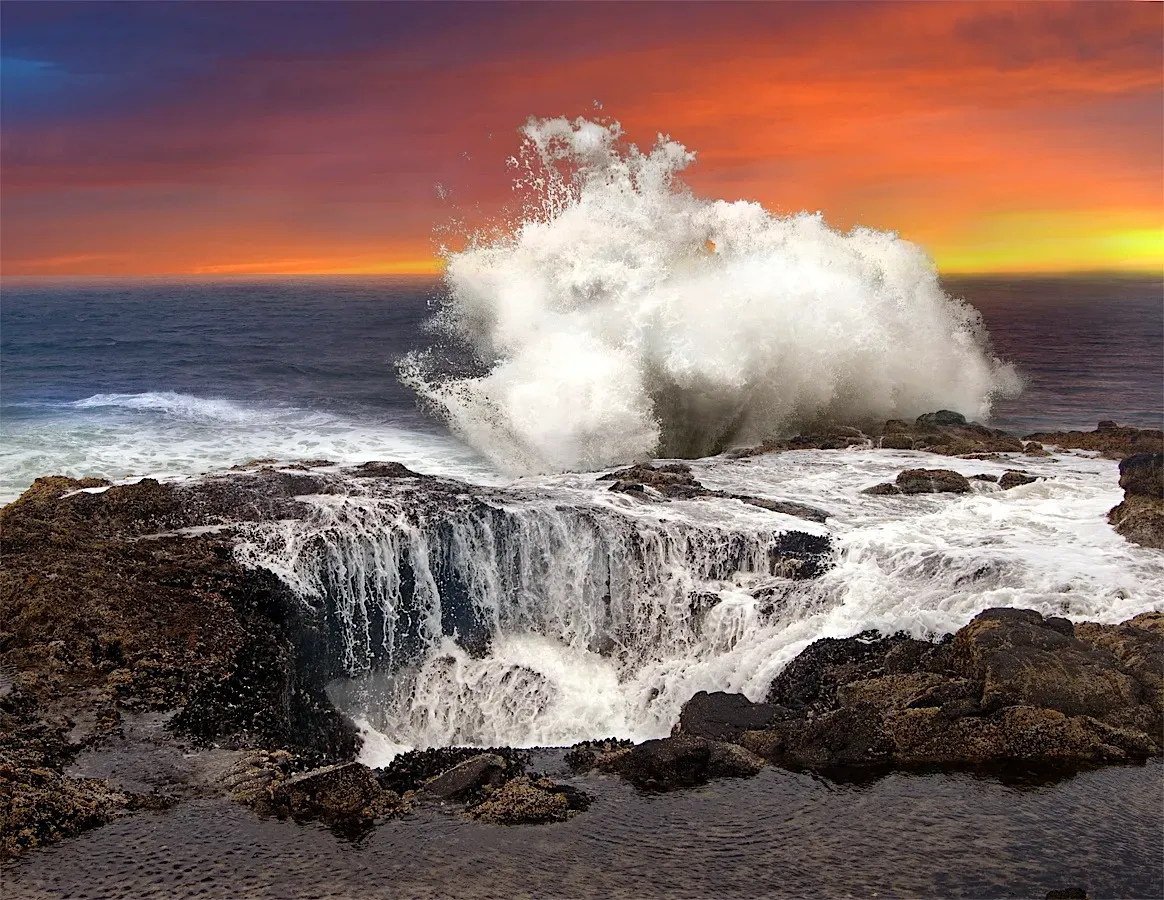
On a stormy day along the central Oregon coast, you can watch waves slam into black volcanic rock, surge upward, then suddenly plunge into a circular opening that looks like a drain in the edge of the continent. This feature, often called Thor’s Well, is probably a collapsed sea cave where waves rush in through a tunnel and then blast back out. The area around it is built from old lava flows and basalt cliffs carved by relentless Pacific surf, so you are seeing both fire and water captured in one dramatic scene.
When you walk the headlands nearby, you notice how the rock under your feet tells a story of eruptions and uplift, followed by millions of years of pounding by waves that exploit every crack. Sea caves, blowholes, and odd pothole-like pools dot the shoreline, changing the way you think about coasts as simple lines between land and water. If you stand at a safe distance and watch the “well” inhale and exhale with each set of waves, you get an almost visceral sense of how dynamic that boundary really is, far beyond the gentle beach stereotype.
6. Lost Lake, Oregon: The Seasonal Lake That Vanishes into Lava
There is a small, scenic lake in the forests of Oregon’s Cascades that, in late spring or early summer, quietly disappears. If you visit Lost Lake at the right time, you see water gurgling into rocky holes in the lakebed and dropping into the darkness of an old lava flow beneath. This region sits on top of thick volcanic deposits, and the ground in places is so fractured and porous that surface water can sink straight down into underground channels instead of flowing out as a normal stream.
From your perspective as a visitor, it feels like a magic trick: one season you paddle a canoe across the full basin, another you walk on exposed mud and rock where the lake once was. In reality, you are watching basic hydrology play out in a geologic setting that makes the plumbing unusually visible. That vanishing act drives home how water in volcanic regions does not just move in rivers and lakes you can see; a whole hidden network of flow can exist beneath you, shaped by past eruptions you never witnessed.
7. Timpanogos Cave System, Utah: Twisted Formations That Seem to Defy Gravity
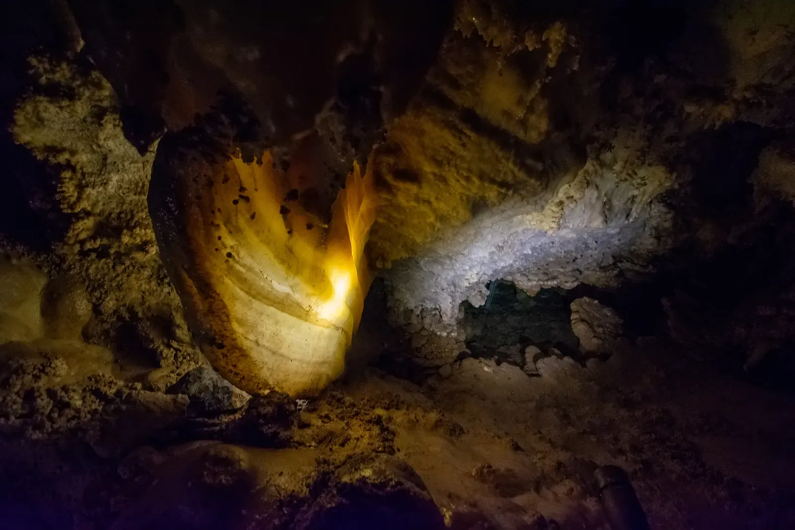
High on the steep limestone flanks of Mount Timpanogos in Utah, a linked set of caves hides formations that look as if someone broke the rules of how minerals are supposed to grow. Inside the Timpanogos Cave system, you see thin, curving speleothems that branch sideways and even upwards instead of hanging straight down like classic stalactites. These so‑called helictites are thought to form when mineral-rich water gets pushed through tiny passages by capillary forces and air currents, leaving calcite in odd, curling paths that seem to ignore gravity.
As you move through the guided route, you also pass familiar cave features with playful nicknames: sheets of flowstone that look like frozen waterfalls, banded formations often described as cave bacon, and knobby lumps of “popcorn” along the walls. What you are really walking through is a three-dimensional record of water working slowly on soluble rock over unfathomable spans of time, drop by drop. The tight switchback trail up the mountainside, with sweeping views of the valley below, only reinforces how different the world looks once you start thinking in terms of rock, water, and time instead of just scenery.
In the end, these seven places remind you that North America is far stranger and more intricate than the handful of famous spots you see on calendars and travel posters. From vanishing lakes and secret crystal cathedrals to badlands that reveal the bones of ancient swamps, each site pulls back the curtain on a different way the planet builds and reshapes itself. The next time you stand on what feels like ordinary ground, will you wonder what quiet geological drama might be unfolding, out of sight, just a little deeper down?