Every so often, Earth throws us a curveball. A mountain stands at the wrong angle, rocks look like they have flowed like liquid, or stones seem to move across the desert floor all by themselves. Geologists are very good at solving puzzles, but some places still feel like they’re winking at us, as if the planet is saying, “You don’t know me as well as you think.”
Most of these formations do have leading scientific theories behind them, but the full picture is often messy, incomplete, and fiercely debated. That tension is exactly what makes them so fascinating. They pull you in with their beauty, then quietly unsettle you by refusing to give up all their secrets.
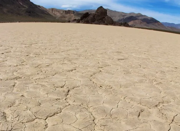
The Sailing Stones of Racetrack Playa, Death Valley
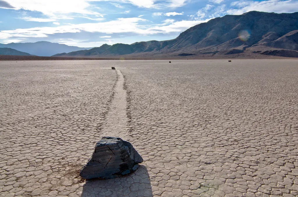
Imagine walking across a dry, cracked desert lakebed and seeing heavy rocks with long, graceful trails carved behind them, as if they’ve skated across the ground while nobody was watching. For decades, that’s exactly what the sailing stones of Racetrack Playa were: a quiet, stubborn mystery in one of the hottest, harshest places on Earth. There were no footprints, no clear push, and no obvious pattern to their paths.
Researchers now lean toward a delicate combo of winter ice sheets, thin films of water, and light winds that slowly nudge the rocks along. Still, the phenomenon feels strangely at odds with the violent image most people have of Death Valley. The idea that something as subtle as paper-thin ice can move rocks that weigh as much as a person feels like a magic trick done in broad daylight. Even with time-lapse footage supporting the theory, standing there in person, staring at those trails, you can’t shake the sense that the desert is alive and quietly rearranging itself when you look away.
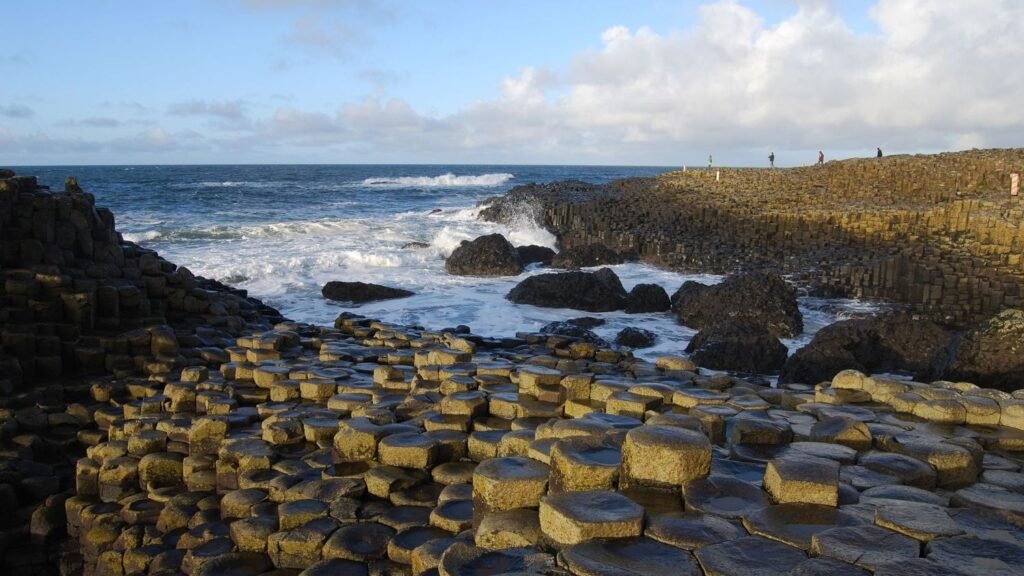
The Giant’s Causeway, Northern Ireland
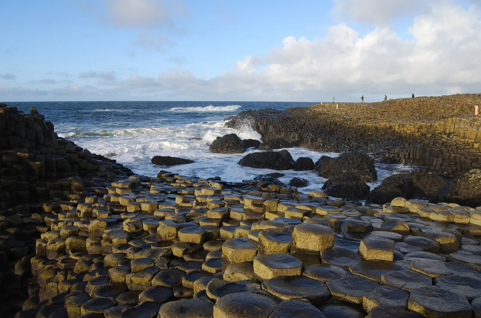
The Giant’s Causeway looks like it was built, not born. Roughly hexagonal basalt columns fit together like tiles laid by some obsessive architect, stepping down into the North Atlantic. The standard explanation is cooling lava that contracted and cracked into polygonal columns, a natural process called columnar jointing. On paper, that sounds neat and tidy. In person, it just feels uncanny.
What throws people off is how precise it appears from certain angles. Many columns are nearly the same width, some stack into organ-pipe cliffs, and the whole thing looks too organized for chaos. Similar formations exist elsewhere, but none quite match the drama and scale of the Causeway. Even if geology classes can walk you through the physics, there’s an emotional gap between having an explanation and feeling like it truly satisfies your brain. This is one of those places where science can be right and still feel incomplete.
Blood Falls, Antarctica
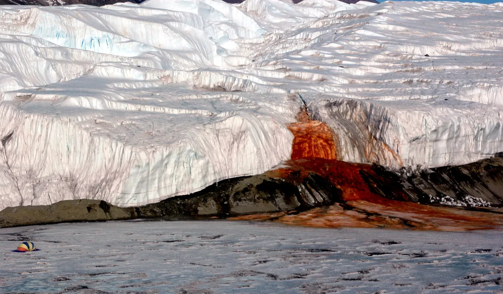
In one of the coldest, whitest places on Earth, a waterfall the color of rusted metal seeps from the face of a glacier and stains the ice below. Blood Falls in East Antarctica looks like something from a horror film: dark red water spilling out of otherwise pristine frozen cliffs. For a long time, the color was largely a visual shock without a clear story behind it.
Today, the leading view is that extremely salty, iron-rich water trapped beneath the glacier is slowly leaking out and oxidizing as it hits the air, turning that striking red. That sounds straightforward enough until you realize this brine has likely been isolated for more than a million years and hosts strange microbial life surviving in total darkness and subzero brine. It turns from a simple color oddity into an unsettling hint that Earth still hides ecosystems that barely fit our current definitions of “normal.” The waterfall is small, but it points to a huge question mark under the ice.
The Eye of the Sahara (Richat Structure), Mauritania
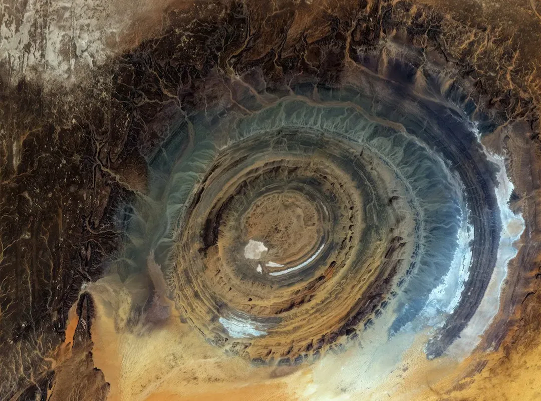
Seen from the ground, the Eye of the Sahara is just a region of eroded plateaus and ridges. Seen from space, though, it’s a perfect target-like bullseye in the middle of the desert: massive concentric rings stretching roughly forty kilometers across. Early astronauts reportedly used it as a visual landmark, because you simply can’t miss it. Its shape looks so deliberate that some people instantly jump to impact craters or even artificial causes.
Geologists mostly interpret the Richat Structure as a deeply eroded, domed uplift of rock layers, where different rock types weathered at different rates to create those circular ridges. That explanation fits a lot of the data, but the near-symmetry and scale keep the debates alive. There’s no clear, sharp rim like a classic impact crater, yet the structure refuses to look completely random. It sits there in satellite images like a fossilized fingerprint of some process we understand in pieces, but not quite as completely as we pretend.
Fairy Circles of the Namib Desert
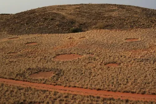
From above, parts of the Namib Desert look like someone took a giant hot poker and pressed it repeatedly into the earth, dotting the landscape with bare, circular patches surrounded by grass. These fairy circles can be just a couple of meters wide or much larger, and they persist for decades. The mystery isn’t just what makes them, but also why they are so evenly spaced, almost like a natural polka-dot pattern stretching to the horizon.
Competing theories blame underground termite networks or self-organizing vegetation patterns where plants “space themselves out” to compete for scarce water. Both ideas have experimental support, but neither fully explains every region where fairy circles appear, or why similar patterns show up in different continents with different species. Standing in one of these circles is eerie: nothing obvious is happening, yet the ground under your feet is part of a puzzle that still doesn’t have a fully agreed-upon solution.
The Moeraki Boulders, New Zealand
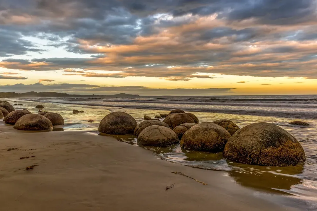
Scattered along Koekohe Beach on New Zealand’s South Island are huge, almost perfectly spherical boulders, some as big as a small car. They sit half-buried in the sand, cracked like giant dinosaur eggs, with smoother stone inside. The prevailing explanation is that they formed millions of years ago as concretions: minerals slowly cementing sediment around a center, growing bit by bit within mudstone that later eroded away.
That process explains why they exist, but not in a way that really kills the wonder. Many concretions are lumpy and irregular; these are startlingly round, and so many similar spheres clustered together feel more like sculpture than accident. Their size, shape, and the way they emerge from cliffs and roll onto the beach make them look staged. It’s the kind of thing that makes you rethink the timescale of geology – how patient, tiny changes can leave behind shapes that feel almost too deliberate for blind chemistry.
Kummakivi Balancing Rock, Finland
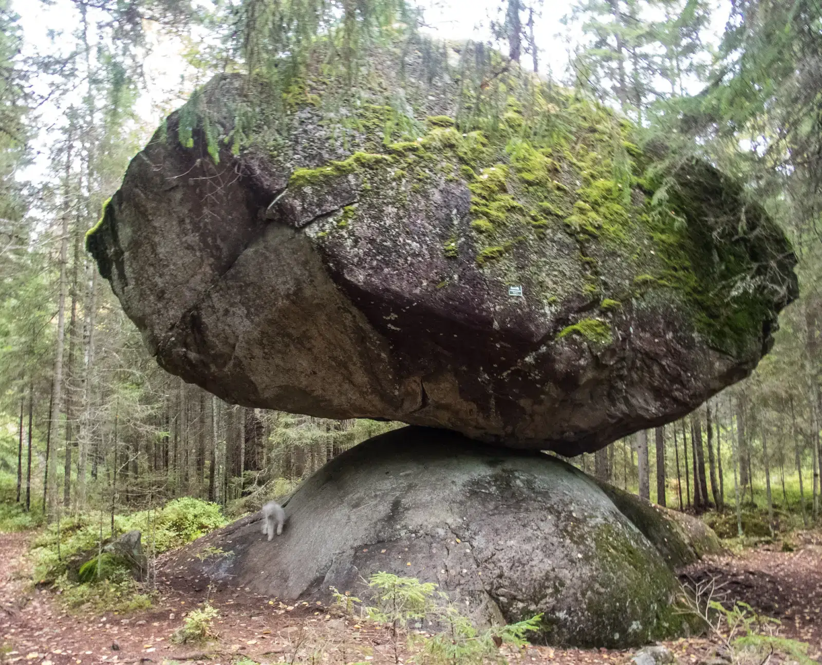
At first glance, Kummakivi in eastern Finland looks like a glitch in gravity. A massive boulder seems to be casually lounging on top of a much smaller, rounded rock, touching it at such a thin contact area that it looks like a stiff breeze should knock it over. Yet it has stayed put for thousands of years, stable enough that official surveys have confirmed it doesn’t budge under reasonable force.
The most accepted idea is that this is a relic of the last Ice Age, when retreating glaciers dumped and nudged giant rocks into awkward positions. Technically, this is consistent with what we know about glacial transport. Emotionally, it’s ridiculous. To stand beneath a many-ton rock that seems almost to float is to feel your body arguing with your brain’s explanation. Even if the physics check out, there’s a sense that nature played a prank and then walked away without bothering to tidy up.
The Zhangye Danxia Rainbow Mountains, China
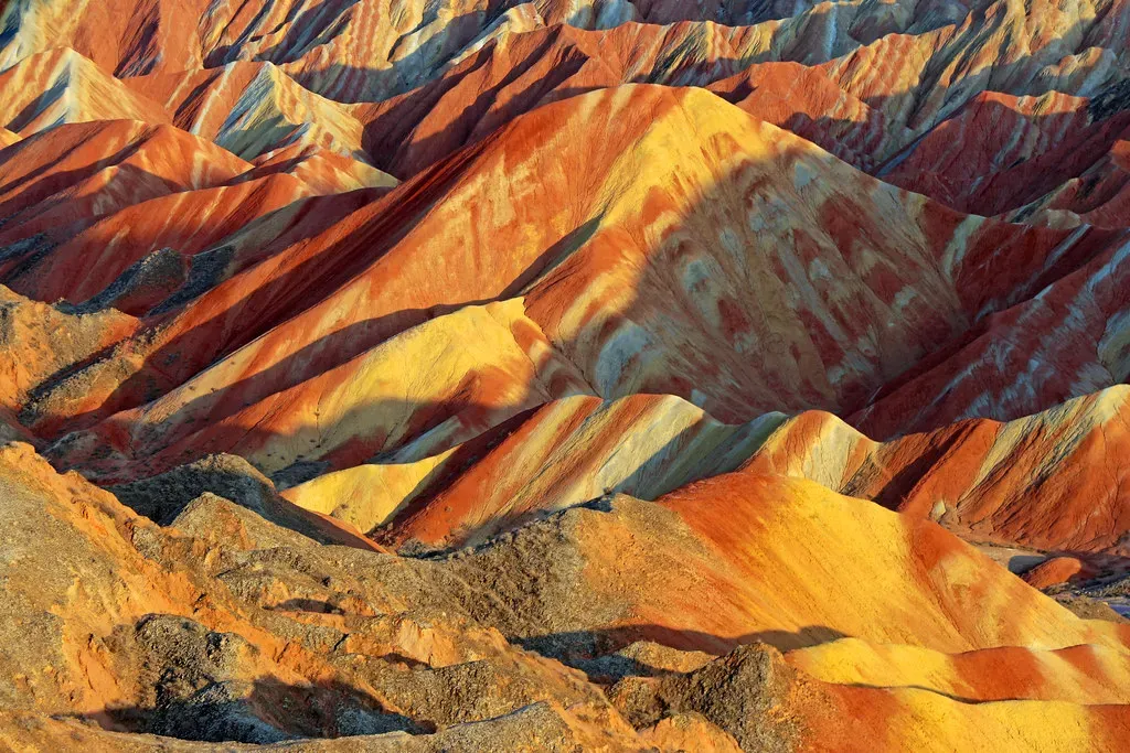
Photos of the Zhangye Danxia landform in Gansu province look edited, like someone dragged the saturation slider a bit too far. Hills and ridges appear painted in stripes of red, orange, yellow, and even hints of blue-gray, creating a surreal, layered rainbow effect. The textbook answer is colored sedimentary rock layers rich in different minerals, tilted and eroded to expose them in cross-section.
Yet even when you know that, the visual impact hits you on a different level. The color banding is so clean and vivid that it almost seems like vandalism by an overly enthusiastic artist. Some scientists argue that while the basic mechanisms are understood, the exact combination of mineralogy, climate, and tectonic history that produced such concentrated, large-scale color contrast is still not perfectly nailed down. It’s a reminder that “we know the general idea” is not the same as “we’ve solved every detail.”
The Hexagonal Mud Cracks of the Atacama Desert
Dried mud cracks aren’t unusual – you can see them in any puddle that has sat in the sun for a while. But in parts of the Atacama Desert in Chile, the world’s driest non-polar desert, some polygonal crack patterns are so regular and persistent that they look engineered. Large, clean hexagons repeat across wide areas, as if the ground tried to imitate a honeycomb or the surface of a cooling lava flow.
Various studies suggest cycles of wetting from rare fog or underground moisture, followed by intense drying, might gradually shape and refine the crack patterns. The twist is that the Atacama is so dry, in many places rain has barely fallen for centuries, so any “wetting” is minimal and sporadic. The sheer regularity and longevity of these geometric patterns still raise questions about exactly how much water, stress, and time are needed to create such order. It feels like an experiment nature is running very slowly, and we’re still only guessing at the setup.
The Boiling River of the Amazon, Peru
Deep in the Peruvian Amazon, far from any active volcano, there is a river hot enough to cause severe burns and, in places, literally cook animals that fall into it. Portions of the Shanay-Timpishka, often called the “boiling river,” reach temperatures close to the point where water turns to steam. That immediately clashes with what most people think they know: boiling rivers should belong near volcanic systems, not in relatively flat rainforest.
The most convincing theory points to a deep hydrothermal system where rainwater seeps far underground, heats up through contact with hot rocks, then returns to the surface through faults and fractures, pooling into the river. That explanation fits the data that has been gathered so far, but the exact plumbing of this thermal system in a non-volcanic setting remains partly speculative. Walking along its banks, feeling the heat rise, you get the sense that Earth’s interior is closer and more complicated here than maps or textbooks suggest. It’s a quiet challenge to our assumptions about where extreme geology “should” happen.
When Earth Refuses to Behave
These formations sit at the edge of what we comfortably claim to understand. In nearly every case, scientists have strong, plausible theories, and in many places, solid evidence. But there are still gaps, odd details, and unnerving levels of order or strangeness that don’t quite fold into a neat, complete story. That friction between explanation and experience is exactly what keeps researchers going back – and what keeps the rest of us fascinated from a distance.
Standing in front of any one of these places, the planet suddenly feels less like a finished book and more like a draft with entire chapters still unwritten. Our models work well enough to send spacecraft to other worlds, yet a rock balanced in a Finnish forest or colorful cliffs in China can still leave us quietly confused. Maybe that’s the real gift of these oddities: they remind us that Earth is not a solved problem, and that curiosity is not a phase humanity grows out of. Which of these places would you most want to see with your own eyes?