You grow up thinking Earth is mostly sorted out. Mountains rise, rivers carve valleys, volcanoes erupt, glaciers scrape rock – it all fits into neat diagrams from school. Then you stumble across a place where rocks slide on their own, a perfect stone eye stares back from the Sahara, or a single tower of lava rises straight out of the prairie, and your mental model just… cracks a little. This is where geology stops feeling like a background subject and starts feeling like a mystery novel. In each of these nine spots, scientists actually do have serious, well‑supported ideas about how things formed – but there’s still enough uncertainty, odd detail, or sheer visual weirdness that when you stand there in person, you feel like nature is toying with you. As you read, imagine yourself actually walking these landscapes, touching the rock, and asking the same question geologists still quietly ask: are you sure we understand this as well as we say we do?
1. Devils Tower, USA – A Lava Tower No One Can Quite Agree On
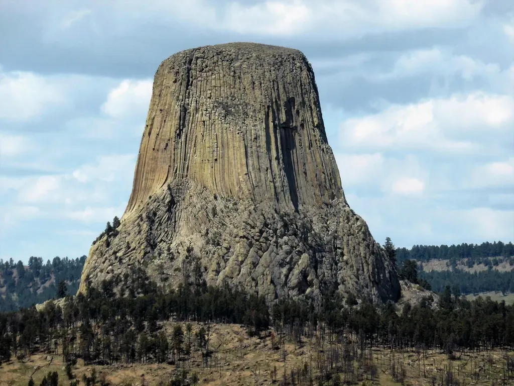
When you first see Devils Tower in northeastern Wyoming, it looks like someone slammed a gigantic stone pillar straight through the surface of the Earth. It rises more than eight hundred feet above its base, the sides almost startlingly sheer, carved into long, vertical grooves that make the whole thing resemble a bundle of hexagonal organ pipes. You know, in a vague way, that it is volcanic, but the moment you ask exactly what kind of volcanic feature it is, the answers start to blur. Some geologists argue you are looking at the cooled remains of a volcanic plug – magma that solidified inside a volcano and was left standing as softer rock eroded away – while others see it as an intrusive body that never quite made it to the surface as a classic volcano at all. ([nps.gov](https://www.nps.gov/deto/learn/nature/geologicformations.htm?utm_source=openai))
What most experts do accept is that you are staring at a spectacular example of columnar jointing, where slowly cooling magma cracked into long, mostly hexagonal columns as it shrank. The pattern is similar to what you’d see at Ireland’s Giant’s Causeway or in some basalt cliffs in the Pacific Northwest, but at Devils Tower those columns are taller and more continuous than almost anywhere else on Earth, which is part of what keeps its exact origin under debate. Even now, questions linger about the depth at which the magma originally cooled, the exact composition of the original volcanic system, and how much surrounding material has been stripped away over millions of years. ([nps.gov](https://www.nps.gov/deto/learn/nature/tower-formation.htm?trk=public_post_comment-text&utm_source=openai))
2. The Sailing Stones of Racetrack Playa, USA – Rocks That Take Themselves for a Walk
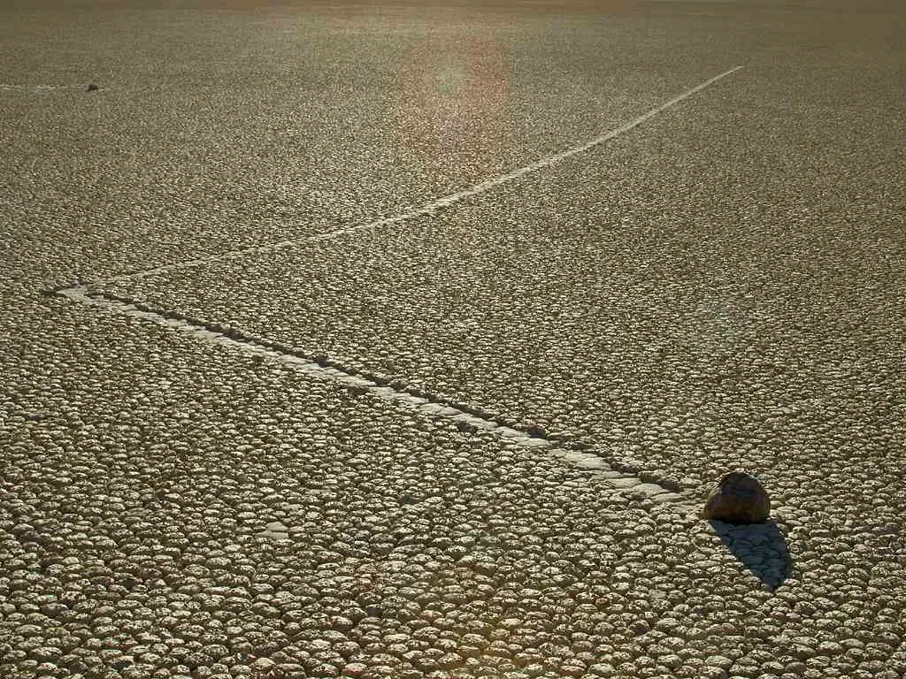
Imagine hiking across a dead‑flat, dried lakebed in California’s Death Valley and finding rocks with long, crisp trails behind them, as if someone had dragged each stone across the mud with invisible string. For decades, that is exactly what you would have seen at Racetrack Playa: lonely stones scattered over the cracked clay, each with its own winding track that sometimes curved, sometimes straightened, and often intersected with others before abruptly stopping. You never saw them move, there were no obvious slope gradients to blame, and there were no signs of human or animal interference. For much of the twentieth century, the only honest description was that these stones appeared to slide themselves across the ground. ([en.wikipedia.org](https://en.wikipedia.org/wiki/Sailing_stones?utm_source=openai))
Today, high‑resolution GPS trackers and time‑lapse cameras have finally caught some of the action in the act, and the explanation is wonderfully strange. Thin sheets of water briefly flood the playa after rare rains, then freeze into thin ice panels on cold nights; as the sun warms things up, light winds push these floating ice sheets, which in turn gently shove the embedded rocks across a film of slippery mud, leaving graceful tracks that can be tens or even hundreds of meters long. In other words, if you visit at the wrong time, you only ever see the before and after, not the delicate dance itself. Even now, the exact details – how often it happens, how crucial specific temperature and wind conditions are – mean that for you, standing on the playa, it still feels like a place where the ground comes to life when you are not looking. ([livescience.com](https://www.livescience.com/planet-earth/geology/racetrack-playa-the-home-of-death-valley-s-mysterious-sailing-stones?utm_source=openai))
3. Richat Structure, Mauritania – The Sahara’s Giant Stone Eye
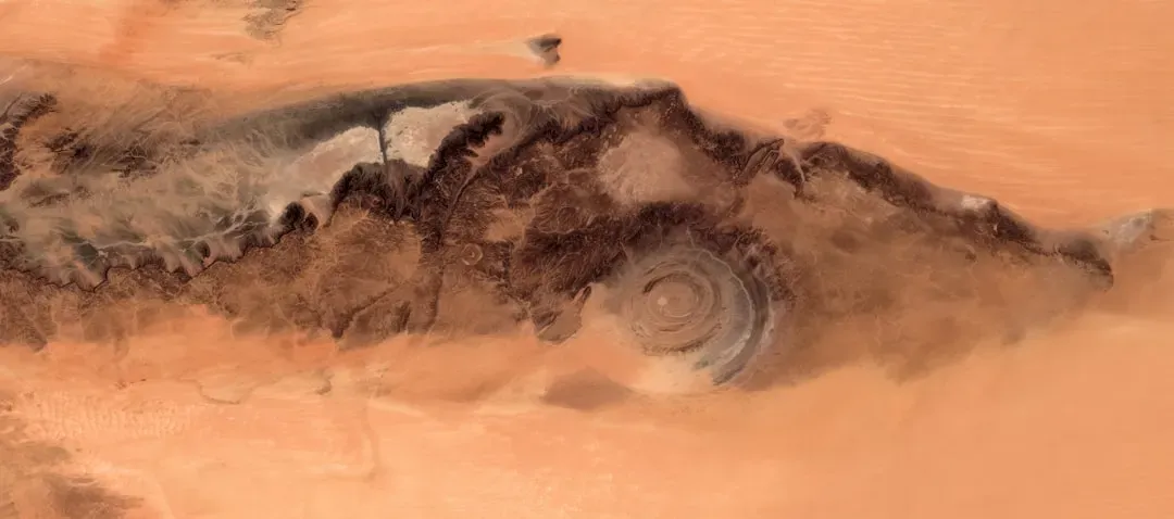
If you open up a satellite map of the Sahara and zoom in on western Mauritania, you eventually stumble on a target‑like set of concentric rings, roughly thirty miles across, etched into the desert plateau. On the ground, this Richat Structure feels like a series of broad circular ridges and valleys, but from above it is so symmetrical that people have nicknamed it the Eye of the Sahara. For years, its origin was wide open to speculation: some early researchers considered a meteorite impact, and popular imaginations have even tried to connect it to the layout of the lost city of Atlantis. The longer you look at it from space, the easier it is to see why your brain wants it to be something dramatic and singular. ([en.wikipedia.org](https://en.wikipedia.org/wiki/Richat_Structure?utm_source=openai))
Modern field work points you toward a more grounded but still intriguing story. Geologists now interpret the Richat as a deeply eroded geological dome – layers of rock that bulged upward in a circular pattern and then wore down, exposing rings of sedimentary and igneous rocks like the cross‑section of a gigantic onion. Low‑temperature hydrothermal fluids seem to have altered parts of the structure, leaving complex breccias and minerals that hint at a long, dynamic history beneath the surface. Even if you accept that it is not an impact crater or a man‑made imprint, the near‑perfect symmetry and the combination of processes that produced it still make you feel as though you are walking around the exposed gears of some buried planetary machine. ([en.wikipedia.org](https://en.wikipedia.org/wiki/Richat_Structure?utm_source=openai))
4. Moeraki Boulders, New Zealand – Near‑Perfect Stone Spheres on a Lonely Beach
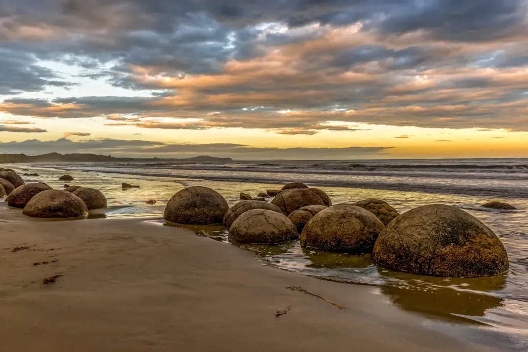
When you step onto Koekohe Beach on the east coast of New Zealand’s South Island, you do not expect to find dozens of giant stone marbles lying casually in the surf. Some of the Moeraki Boulders are small enough to straddle; others are more than two meters across, nearly perfect spheres that look like props left over from a fantasy film. Many are cracked into polygonal plates, and a few have split open to reveal honeycomb interiors lined with crystals. You can easily imagine they rolled down from a cliff or were sculpted by waves, but then you realize they actually emerge slowly from the soft mudstone of the shoreline itself, as if the cliffs are hatching them. ([newzealand.com](https://www.newzealand.com/int/feature/moeraki-boulders/?utm_source=openai))
Geologists describe these boulders as concretions, which means they formed gradually inside ancient marine sediments as minerals, mainly calcite, cemented the surrounding mud and silt into solid rock long before the rest of the layer hardened. Over millions of years, erosion stripped away the softer material and left these spherical cores behind, still riddled with radiating cracks filled with calcite or other minerals. That broad explanation makes sense, but it does not fully answer why the spheres here grew to such extraordinary sizes, nor why similar beaches around the world rarely display such a dense cluster of giants. Standing among them at low tide, you feel as though you have wandered into a game the Earth started playing in the Paleocene and never quite finished explaining. ([en.wikipedia.org](https://en.wikipedia.org/wiki/Moeraki_Boulders?utm_source=openai))
5. The Stone Forest of Shilin, China – Karst That Looks Like a Petrified City
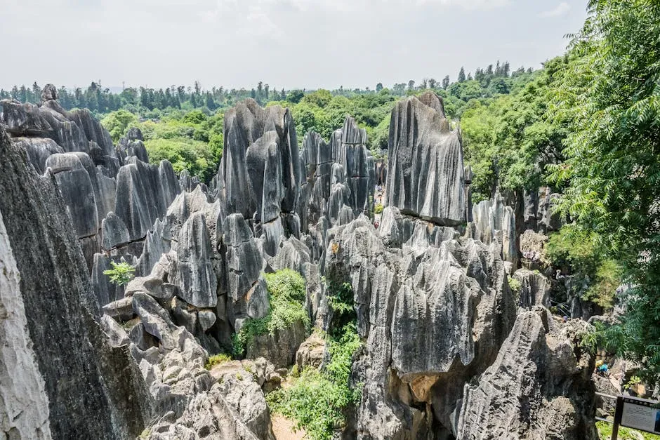
In China’s Yunnan Province, you can walk into a landscape where towering gray pinnacles rise straight out of the ground, some as tall as small buildings, packed so tightly they resemble the ruined walls and alleys of some long‑lost stone metropolis. This is the Shilin Stone Forest, and at first glance you might think you are looking at volcanic spires or carved monuments. But as you pick your way through the maze of narrow passages and needle‑sharp towers, you begin to see subtle layering and solution grooves that hint at something much slower and more patient than fire or chisels. You realize that what surrounds you began as relatively ordinary limestone beds.
The Stone Forest is a masterclass in karst, the landform that develops when slightly acidic water dissolves soluble rocks over immense spans of time. In Shilin, groundwater and surface water seem to have exploited small fractures, gradually widening them into gullies while leaving behind blades and columns of more resistant limestone. Differential erosion, joint patterns, and fluctuating water tables all contributed, but the exact sequence and climate history that produced such dramatic relief right here – and not in countless similar limestone regions – still gives geologists plenty to argue about. As a visitor, you mostly notice that nothing else you have seen in nature seems to prepare you for the feeling of wandering through what looks like a fossilized forest that never had trees.
6. Blood Falls, Antarctica – A Rust‑Red Waterfall in a World of Ice
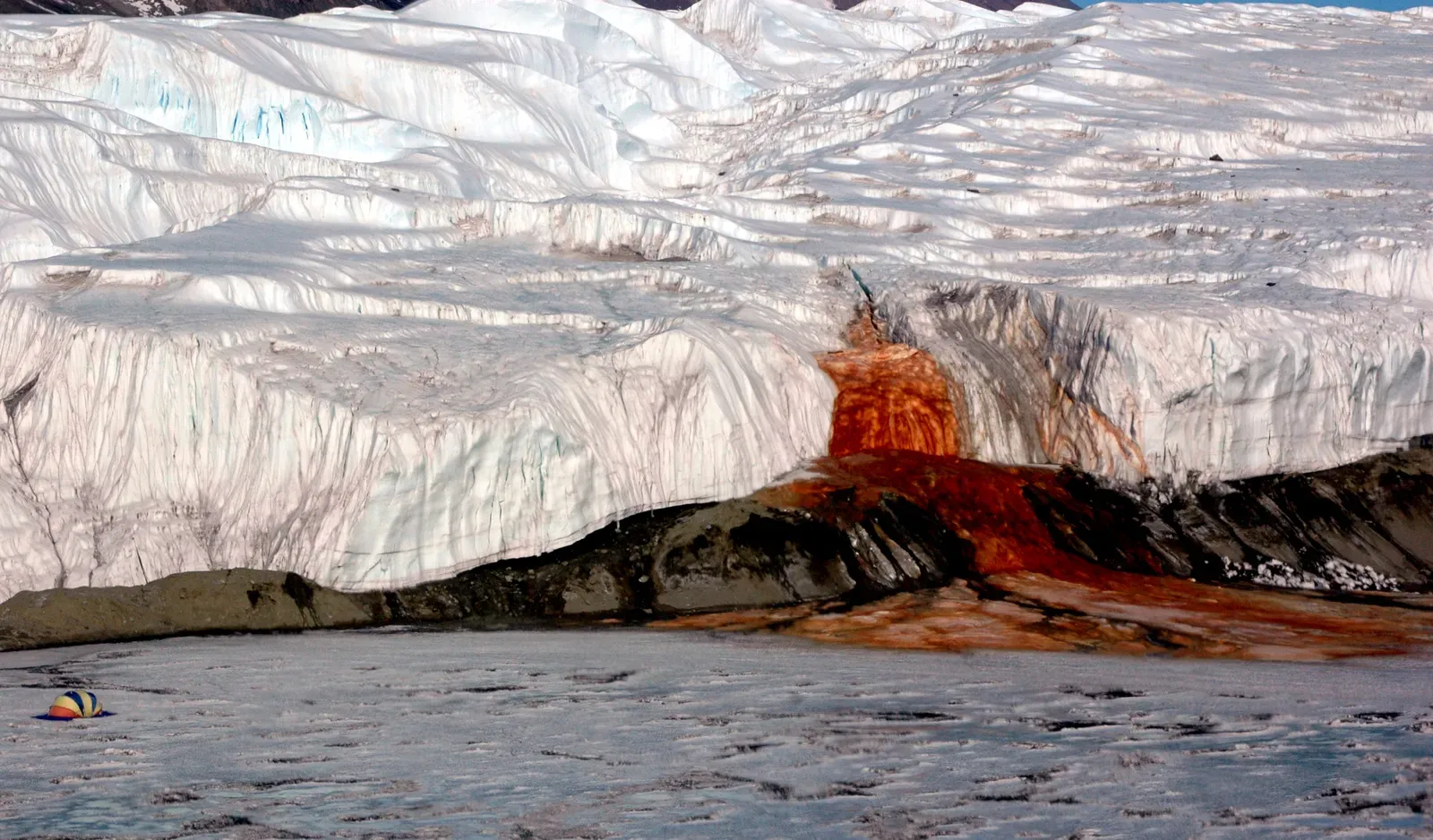
Antarctica is a place you expect to be visually simple: just white ice, blue shadows, and maybe some dark rock peeking through. That is why, when you come across Blood Falls at the edge of Taylor Glacier in the McMurdo Dry Valleys, it hits you so hard. Out of an opening in the ice, a small but striking waterfall tumbles in slow motion, stained a deep rusty red that looks uncannily like spilled blood running over a frozen white cliff. It is the kind of sight that prompts an immediate gut reaction, long before your rational mind catches up.
Researchers have linked the color to iron‑rich, extremely salty water trapped beneath the glacier, likely in an isolated subglacial brine that has been sealed off for a very long time. When this water seeps out and contacts oxygen, dissolved iron oxidizes and turns that vivid reddish hue, painting the ice in streaks that look fresh even though the flow is often sluggish. What keeps this system bizarre is the combination of factors: the hypersaline chemistry, the possible presence of unusual microbial communities adapted to dark, oxygen‑poor brines, and the persistence of the flow in one of the coldest, driest environments on the planet. Even if you accept the geochemical explanation, the idea that a hidden pocket of ancient, iron‑laden water is quietly bleeding through a glacier still feels closer to science fiction than to the neat diagrams you saw in textbooks.
7. The Fairy Circles of Namibia and Western Australia – Polka Dots the Desert Will Not Explain
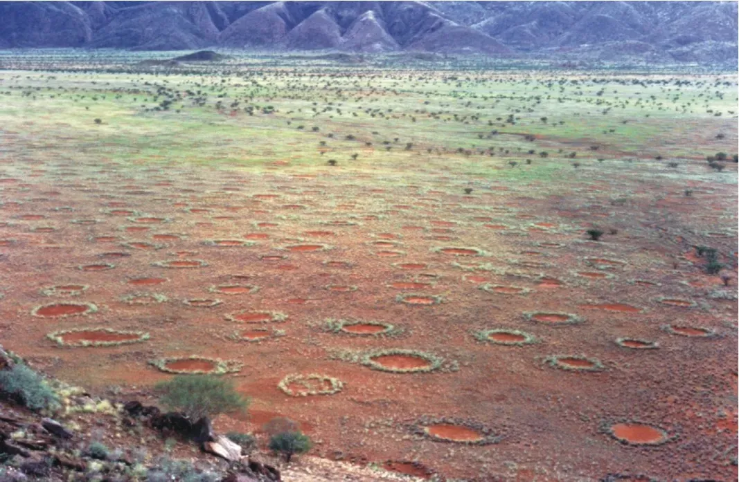
Picture yourself looking down on a grassy desert plain in Namibia and seeing an endless pattern of almost circular bare patches, each a few meters to tens of meters wide, dotting the landscape like the holes in a gigantic piece of Swiss cheese. These so‑called fairy circles are astonishingly regular in size and spacing when viewed from the air, and they persist for years or even decades before fading and being replaced by new ones. You might initially blame termites, gas emissions, or some kind of plant disease, but the more you read, the more you realize scientists are still arguing fiercely about what is truly in charge here.
Some studies point toward sand termite colonies, which may clear vegetation to control soil moisture and create stable foraging territories, while others highlight how plants themselves, competing for scarce water, can self‑organize into repeating gap patterns. In recent years, almost identical formations have been documented in parts of Western Australia, suggesting that whatever causes them is not unique to one continent. What makes these circles so compelling for you is that both sides in the debate can point to good data and realistic models, yet no single explanation seems to satisfy every observation. You are left with a living landscape that, even in the age of satellites and supercomputers, manages to keep its core secret just out of reach.
8. The Giant’s Causeway, Northern Ireland – A Basalt Puzzle That Looks Too Perfect
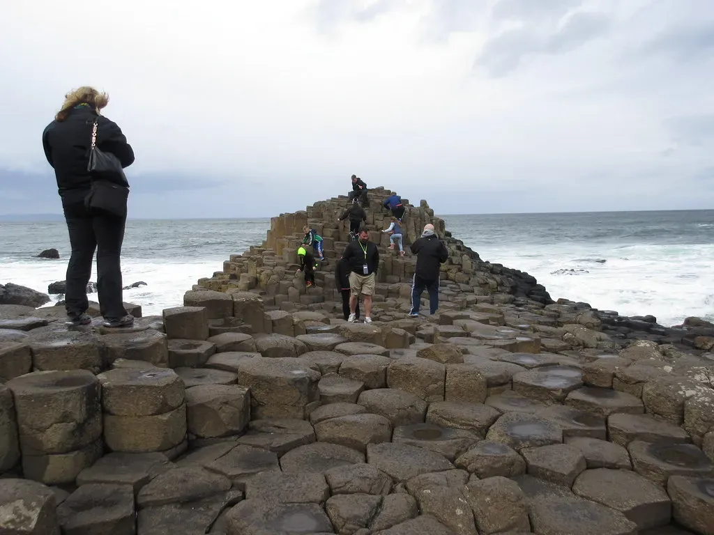
When you step onto the Giant’s Causeway on the coast of Northern Ireland, it feels less like a beach and more like the floor of some alien temple. Around forty thousand interlocking basalt columns form natural stepping stones that lead from the base of the cliffs straight into the sea, many of them with almost perfect hexagonal tops that fit together like a stone honeycomb. You know, conceptually, that this is the product of volcanic activity, but your eyes insist someone must have carved it. The columns rise to different heights, forming wild, irregular stairways and platforms that look designed rather than accidental.
The basic framework is this: around fifty to sixty million years ago, a large lava flow cooled and contracted, and as it did, it cracked into a pattern of mostly hexagonal columns – the same columnar jointing style you saw at Devils Tower, but here laid out horizontally and sliced off near their bases. Laboratory experiments and computer models have shown that materials that shrink as they cool naturally tend to form these hexagonal grids, much like dried mud does in miniature. Yet even with that understanding, questions remain about exactly how cooling rates, lava thickness, and groundwater interactions combined to produce such a vast, consistent field of columns in this specific place. Standing there with the Atlantic wind in your face, you can accept the physics and still feel as if you are walking across the frozen surface of some huge, interrupted experiment.
9. The Boiling River of the Amazon, Peru – A Scalding Mystery Far from Any Volcano
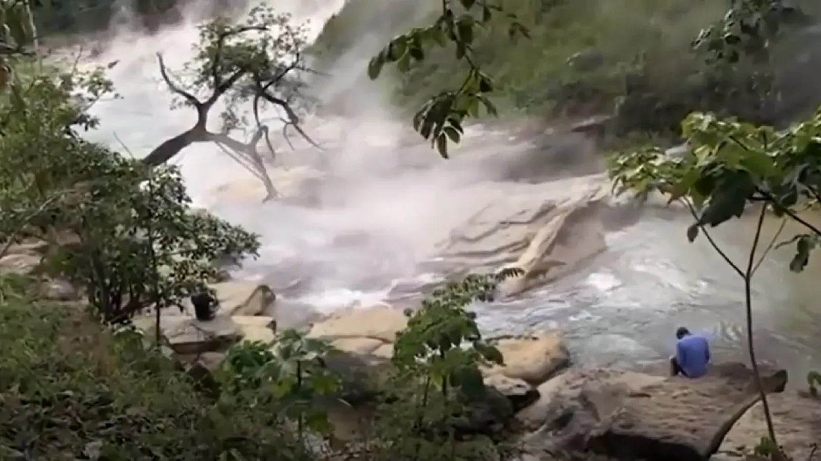
In the Peruvian Amazon, far from any active volcano or industrial plant, there is a river so hot in stretches that animals unlucky enough to fall in can be cooked alive. Local communities have known about this boiling river for generations, but when you hear about it for the first time, it sounds almost impossible. Most naturally boiling or near‑boiling waters on Earth are tied directly to volcanic or geothermal fields near plate boundaries, yet here you are dealing with a long, flowing river deep in the rainforest, many kilometers away from the nearest obvious magmatic heat source.
Investigations suggest that rainwater percolates deep into the Earth through faults, is heated by the planet’s internal warmth far below the surface, and then rises back up along fractures to feed the river with intense geothermal energy. Still, the specifics of the plumbing system remain uncertain, and mapping the underground pathways in such a remote, dense jungle is extremely challenging. When you imagine standing on the banks, watching steam curling off the surface while the surrounding jungle hums with life, you are confronted with a stark reminder: the interior of the Earth is not some uniform, well‑charted space. It is full of hidden routes and local anomalies that can create a literal river of hot water where, by all your textbook expectations, there should only be another stretch of warm, muddy stream.
Conclusion – When Solid Ground Refuses to Be Simple
All your life you have been told that geology is the study of slow, predictable processes: erosion, sedimentation, plate motion, and the steady cooling of a rocky planet. Then places like Devils Tower, the Richat Structure, or the sailing stones yank that reassuring story sideways. Each of these formations is, in its own way, well enough understood to fit into mainstream science, yet odd enough that it keeps specialists publishing papers, arguing over mechanisms, or tweaking models decades after the first serious studies began. They occupy that delicious middle ground where you can say, with a straight face, that you know what is going on – and in the next breath admit that the details still keep you up at night.
If you ever get the chance to visit any of these sites, the most powerful thing you can bring is not a camera but a habit of paying attention. Notice how often the explanations you hear are framed with words like probably, likely, or best supported; notice how much of modern geology is comfortable living with uncertainty while still rejecting wild, unfounded fantasies. These landscapes do not actually defy explanation, but they do defy your desire for tidy, final answers. And maybe that is the real gift they offer: a reminder that even on a planet humans have mapped, mined, and modeled for centuries, the ground beneath your feet can still surprise you. Which of these places would you be brave – or curious – enough to see first?