You probably grew up hearing that great civilizations fall because of wars, bad leaders, or moral decay. That story is comforting, because it makes collapse feel like a choice someone else made badly. But when you look closely at the archaeological evidence, a far colder villain keeps showing up in the ruins: sudden, brutal shifts in the environment that no one fully saw coming. Droughts that lasted centuries, rivers that changed course overnight, volcanoes that blotted out the sun, and storms that shredded coastlines rewrote human history again and again.
As you walk through these ten vanished worlds, you are not just looking backward at lost cities and broken statues. You are looking into a mirror that reflects your own era of rising seas, record heat, and stressed food systems. The people in these stories were clever, organized, and often advanced for their time, yet many still misread the warning signs or doubled down on fragile systems until it was too late. Their experience does not give you easy answers, but it does give you patterns, clues, and a sharp question: how different are you, really, from them?
The Akkadian Empire: When A Super Drought Broke The First Great Empire
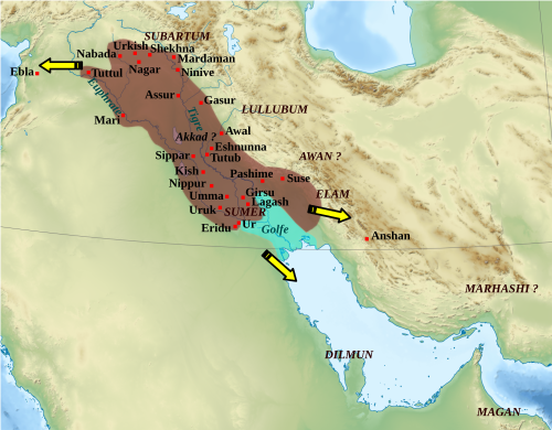
If you could travel back to around 2300 BCE in Mesopotamia, you would find yourself standing in the heart of the world’s first true empire. The Akkadian Empire stitched together cities, languages, and peoples from what is now Iraq to parts of Syria, thriving on irrigated fields fed by the Tigris and Euphrates. For a while, it looked unstoppable, with armies marching in formation and administrators moving grain and silver like pieces on a board.
Then the climate turned against them. You would see rainfall patterns shift to the north, dust storms sweep across once-fertile plains, and harvests shrink for decades on end. Archaeologists have found layers of windblown dust and abandoned settlements that match a long, intense drought. As farmers fled failed fields and pressure from hungry nomadic groups increased, the empire’s fragile political web snapped. You watch a pattern that feels uncomfortably familiar: leaders try to govern a climate problem like a simple security issue, and by the time they realize it is deeper than that, the system they depend on is already in free fall.
The Maya Cities Of The Lowlands: Stone Pyramids, Empty Reservoirs
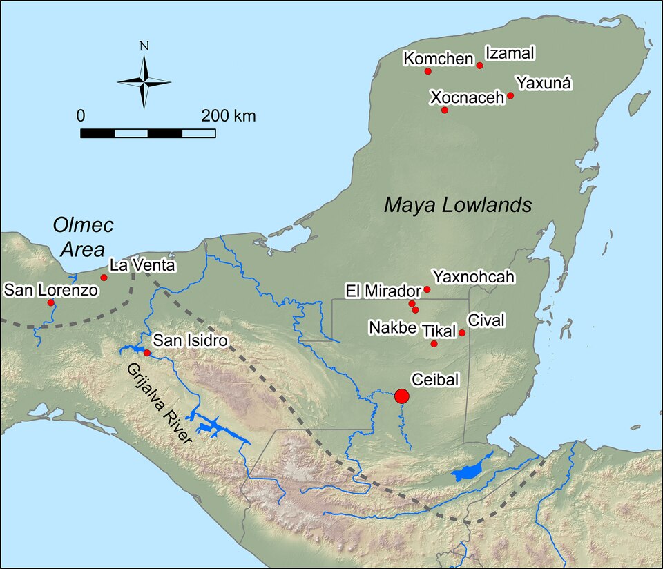
When you picture the Classic Maya, you probably imagine tall pyramids rising from the jungle, carved stelae, and a complex calendar. What you might not picture is how obsessed they were with water. In the lowlands of what is now Guatemala, Belize, and parts of Mexico, you would live with long dry seasons, so you would dig reservoirs, manage forests carefully, and time planting and rituals to the rains. For centuries, that dance between water, forest, and food worked extraordinarily well.
Then, over several centuries between roughly the seventh and tenth centuries CE, the rains started to fail again and again. You would watch water levels in reservoirs drop, hilltops erode as trees were cut, and cities like Tikal and Copán slowly lose their grip as droughts became more frequent and severe. Written glyphs stop getting carved, monuments are left unfinished, and elites lose their ability to promise abundance. The people did not vanish overnight; they moved, restructured, and survived elsewhere. But those glittering lowland city-states, so dependent on precise water management, could not withstand repeated climate shocks layered on top of political rivalries and social strain.
Angkor And The Khmer Empire: A Water Machine That Became A Trap
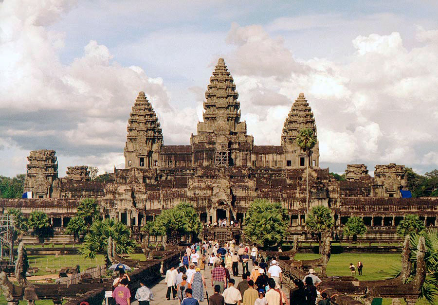
If you walked into Angkor at its height around the twelfth or thirteenth century, you would feel like you had entered a city built around water rather than streets. Canals, huge reservoirs, and engineered embankments turned the monsoon into a predictable engine that fed rice paddies and temples across what is now Cambodia. You would be dazzled not just by Angkor Wat itself, but by the invisible logic: water routed, stored, and reused so carefully that it felt like the climate had been tamed.
But you know monsoons are not actually tame. Tree-ring and sediment records show that Angkor was hit by sequences of severe droughts punctuated by intense floods in the fourteenth and fifteenth centuries. In that scenario, the very complexity of the water system becomes a weakness. You would see canals erode, dikes collapse under extreme flows, and sections of the hydraulic network clog or fail. As repairs fell behind and regional trade and politics shifted, the city’s core hollowed out. People did not stop living in the region, but the gigantic, water-dependent capital that once dominated mainland Southeast Asia faded, leaving you with sprawling ruins where water once obeyed human plans – until it did not.
The Indus Valley Civilization: Cities That Vanished With A Wandering River
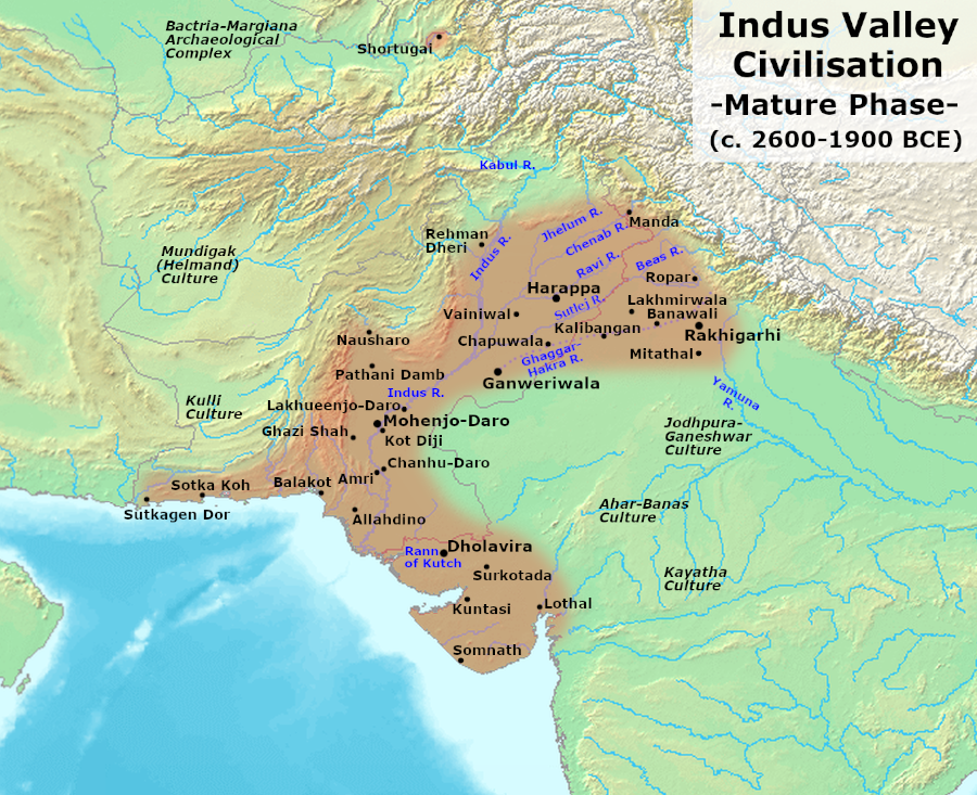
If you tried to map the Indus Valley Civilization in your mind, you might think of it as a quieter rival to Mesopotamia and Egypt. In cities like Mohenjo-daro and Harappa, you would walk past straight streets, standardized brick houses, drainage systems, and public baths. What you would not see much of is the drama of kings or war carved into stone. Instead, you would see a culture that looked surprisingly urban and organized, humming along on river-fed agriculture and trade.
Then the river patterns shifted. Geological evidence suggests that key rivers, including what many researchers link to the ancient Sarasvati, changed course or dried significantly as monsoon patterns weakened. If you were a farmer then, your dependable floods would become unreliable, your irrigation would falter, and your city’s lifeline would fray. Over centuries, you would watch populations drift eastward toward the Ganges plain, large cities shrink or be abandoned, and material culture fragment into smaller regional traditions. The collapse here feels more like a long exhale than a sudden crash – but at its core, you are still looking at a civilization undone by the slow but decisive loss of the watery foundation it had taken for granted.
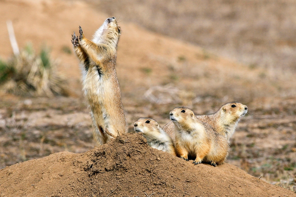
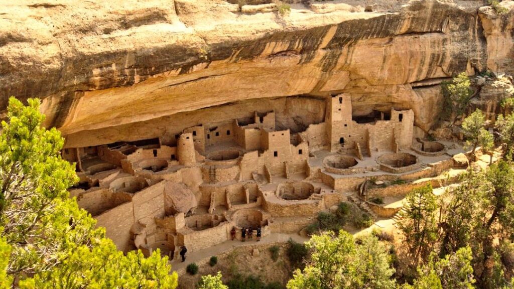
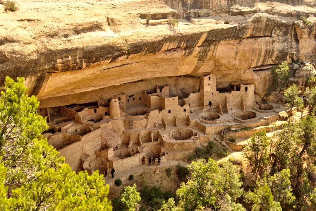
The Ancestral Puebloans At Chaco And Mesa Verde: Stone Cliffs, Empty Kivas
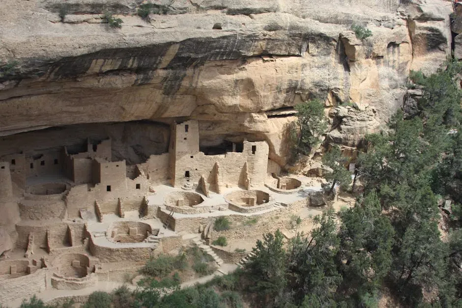
In the high desert of the American Southwest, you can still stand inside the great houses of Chaco Canyon and the cliff dwellings of Mesa Verde and feel how much effort went into living in such a harsh landscape. As part of the Ancestral Puebloan world, you would grow corn, beans, and squash in marginal soils, carefully manage woodlands, and build elaborate ceremonial and trade networks to knit scattered communities together. For generations, that balancing act worked, even in a region where rainfall is always a gamble.
Then came prolonged droughts, especially during the so-called Great Drought in the late thirteenth century, layered on top of deforestation and soil exhaustion. If you were there, you would notice springs weakening, crop yields falling, and conflict pressures rising as different groups competed for shrinking pockets of reliable land. Archaeological evidence shows abandonment of major sites, burned structures in some areas, and a gradual migration south and east toward more dependable water and farmland. When you look at the empty kivas and silent cliff dwellings today, you are really looking at the trace of people who read the writing on the wall – too little water, too many people – and chose to leave rather than die where they stood.
The Moche Of Peru’s North Coast: Drought, Flood, And A Broken Faith
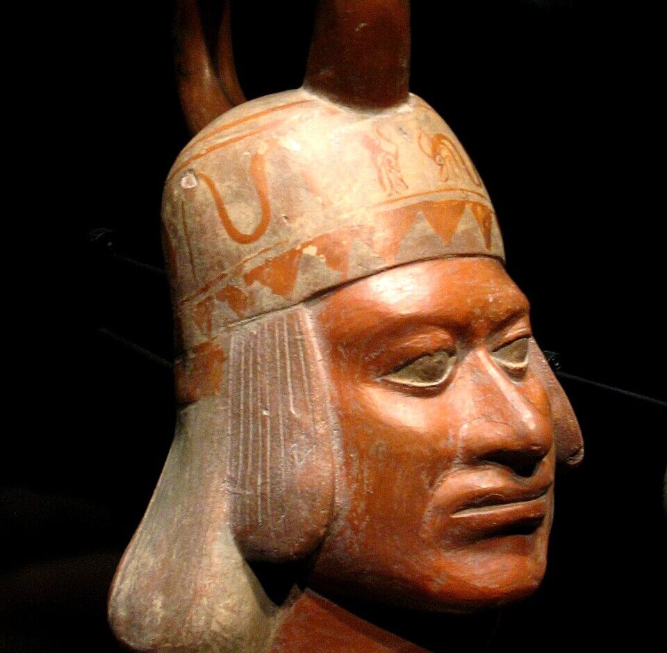
On the north coast of what is now Peru, the Moche built adobe pyramids, irrigated valleys, and a rich artistic tradition centuries before the Inca. If you lived there, you would depend on a precarious gift: rivers fed by Andean snowmelt in a strip of desert that should have been barren. You would also live under the shadow of a powerful climate system you could not name but felt in your bones: the pattern now called El Niño, which can swing the region from drought to catastrophic floods.
Evidence from ice cores, sediments, and ruined irrigation canals points to a period of repeated extreme climate swings around the sixth to eighth centuries CE. You would see years of crushing drought, followed by seasons where warm Pacific waters triggered torrential rains that tore up fields and buried villages in mud. In that chaos, political authority, which had been tied to the ability to manage water and appease the gods, faltered. You might shift your loyalty to new centers inland or higher up, as coastal zones became harder to rely on. The Moche did not vanish entirely, but their distinctive, centralized culture broke apart under the weight of an environment that refused to stay within normal bounds.
The Norse Greenlanders: Farming At The Edge Of An Icy World
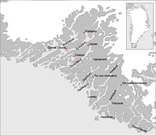
If you sailed with the Norse to Greenland around the late tenth century, you would find a surprisingly familiar sight: farms, churches, cattle, and fields carved out along fjords. You would try to recreate a Scandinavian way of life in a marginal Arctic setting, depending on a slightly warmer climate period that made pastures just viable enough. For a while, you would trade walrus ivory and other goods with Europe and feel like you had pushed the frontier of your world successfully outward.
Then the climate shifted toward what you now call the Little Ice Age. Winters lengthened, summers shortened, and hay yields dropped. Sea ice increased, making trade voyages more dangerous and less frequent. If you were a Greenland farmer then, you would watch your livestock weaken, your stores run thin, and your contact with the wider world fade. Instead of fully adapting to Inuit techniques that worked better in that environment, many Norse settlers clung to their old model until it simply stopped working. By the fifteenth century, the last church records and archaeological traces suggest that the community winked out, leaving ruins that now sit in a landscape even harsher than the one they first braved.
The Bronze Age Eastern Mediterranean: A Web Of Kingdoms Cut By Drought
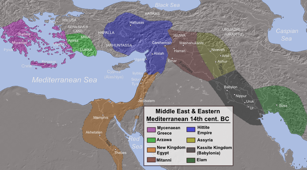
Imagine living around 1200 BCE in the eastern Mediterranean. You would be part of a buzzing network of powers: the Hittites in Anatolia, the New Kingdom of Egypt, city-states like Ugarit, and the Mycenaeans in Greece. Ships crisscrossed the sea trading tin, copper, grain, and luxury goods. Writing, diplomacy, and royal marriages stitched this whole region together in what many historians now see as one of the first truly globalized systems.
Then, in a relatively short span of time, much of that world unraveled. Drought evidence from pollen, sediments, and inscriptions points to repeated crop failures that strained kingdoms already juggling wars, internal politics, and the movement of people often labeled as Sea Peoples. If you were a farmer or merchant, you would feel the anxiety in empty granaries and delayed shipments long before palaces burned. As harvests failed across multiple regions at once, the system lost its slack; a shock in one area could no longer be smoothed over by surplus from another. Cities were destroyed or abandoned, trade routes broke, and literacy rates plunged. What you see in this collapse is not just environmental change, but how brutally it can act on a tightly interconnected but brittle network.
Rapa Nui (Easter Island): Forests Gone, Statues Watching

When you picture Rapa Nui, you probably think of the massive stone statues, the moai, staring out over an empty horizon. If you had arrived there a thousand or so years ago, you would have seen something very different: a remote Pacific island covered in palm forests, seabirds crowding the cliffs, and Polynesian settlers working out how to sustain life in deep isolation. You would rely on your canoes, your crops, and your deep knowledge of the sea and sky.
Over time, the island’s forests disappeared through a mix of human use, introduced species, and natural vulnerability, leaving the soil exposed and resources more limited. When you layer that environmental fragility with factors like changing climate conditions and social competition, the system becomes delicate. You would feel the squeeze in declining timber, less fertile soils, and fewer birds. People adapted in creative ways, building rock gardens and new food strategies, but the society that once had the capacity to move huge stones and possibly build ocean-going canoes changed dramatically. The moai that tourists see today stand in a mostly treeless landscape that tells you how quickly a small, closed system can tip once key resources are pushed beyond their safe limits.
The Cahokia Chiefdom Near The Mississippi: Mounds, Floods, And A Sudden Quiet
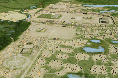
Near present-day St. Louis, you can still see the largest earthen mound in North America rising from a patch of green. If you visited Cahokia around the twelfth century, you would be walking through a sprawling city with plazas, wooden palisades, neighborhoods, and ceremonial spaces. Corn agriculture, river trade, and political and religious authority made it the beating heart of a wide region. From your vantage point on Monks Mound, it would feel like this center would anchor the Mississippi valley for ages.
Instead, by the fourteenth century, Cahokia had largely emptied out. Evidence points to a mix of environmental stresses: changing flood patterns in the Mississippi bottomlands, episodes of drought, and soil exhaustion from intensive farming. You would notice fields becoming less reliable, settlements shifting, and perhaps an uptick in conflict or social tension as people scrambled for better land. When harvests and floods no longer matched expectations, the authority of leaders tied to fertility rituals would weaken. Eventually, populations dispersed into smaller communities across the region. Standing on the quiet mounds today, you are looking at how even a powerful inland center can be undone when its river and climate no longer behave as expected.
Conclusion: What These Lost Worlds Whisper To Your Future
As you step back from these ten stories, you start to see the same threads weaving through very different times and places. Each civilization built its success on an environmental bargain: reliable rivers, predictable rains, manageable forests, tolerable temperatures. Each one pushed that bargain hard, sometimes brilliantly managing water and land, sometimes overreaching. When climate or ecosystems shifted suddenly, the systems that looked strong from the outside often turned out to be brittle, especially when leaders treated environmental warning signs as temporary annoyances instead of structural threats.
You live in a world that is far more interconnected and technologically capable than anything these societies could imagine, but you are still bound by the same basic math of water, food, energy, and habitability. Their ruins are not just cautionary tales; they are case studies in what happens when you ignore slow changes, assume tomorrow will resemble yesterday, or build complex systems without enough flexibility. If you listen carefully, what they are really asking you is simple and unsettling: now that you know how often sudden environmental collapse has rewritten history, what are you going to do differently?