One of the strangest truths about living in the United States is that you can go years without thinking about earthquakes, then have your entire sense of safety flipped in a few violent seconds. The ground feels like the one thing in life that is supposed to be non‑negotiable, permanently stable. When it suddenly shudders, cracks, and heaves, it is more than a natural disaster; it is a psychological reset button that forces us to rethink where and how we live.
Looking back at the most powerful earthquakes in U.S. history is like reading a brutally honest diary kept by the planet itself. Each quake left a scar on the landscape, but also carved a new line in the scientific record, pushed engineers to rethink how to build, and exposed the quiet blind spots in how communities prepare. These ten historic events do not just tell us what happened; they reveal how unpredictable, fragile, and surprisingly adaptable our relationship with the ground beneath us really is.
1. 1964 Great Alaska Earthquake (Magnitude 9.2)
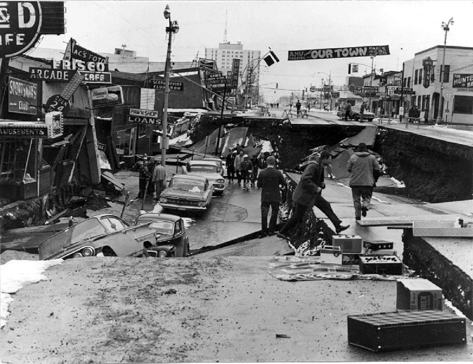
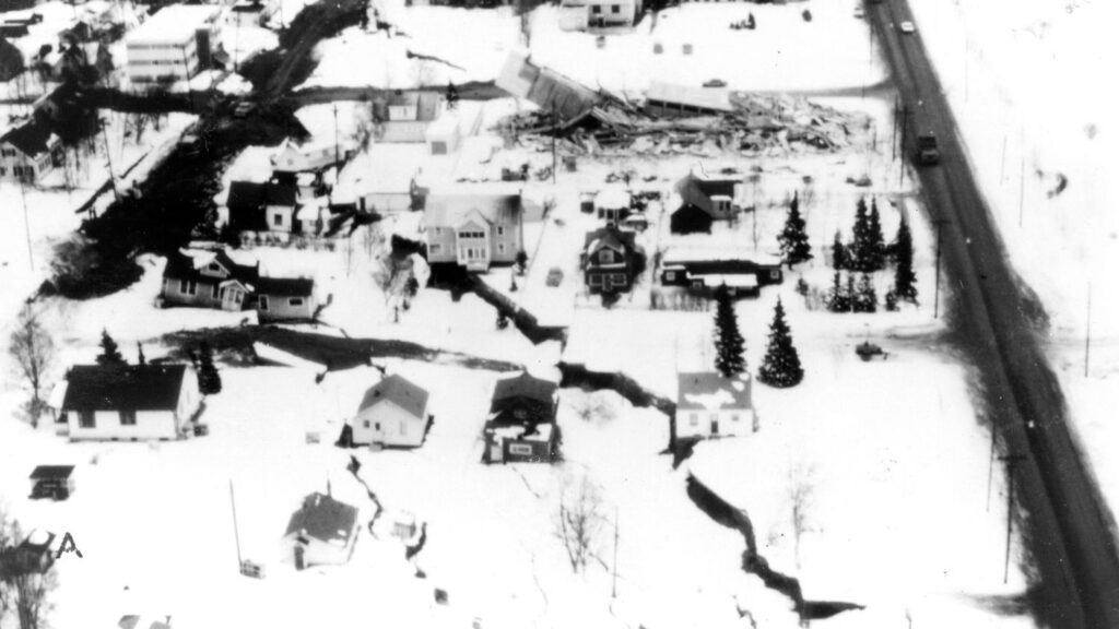
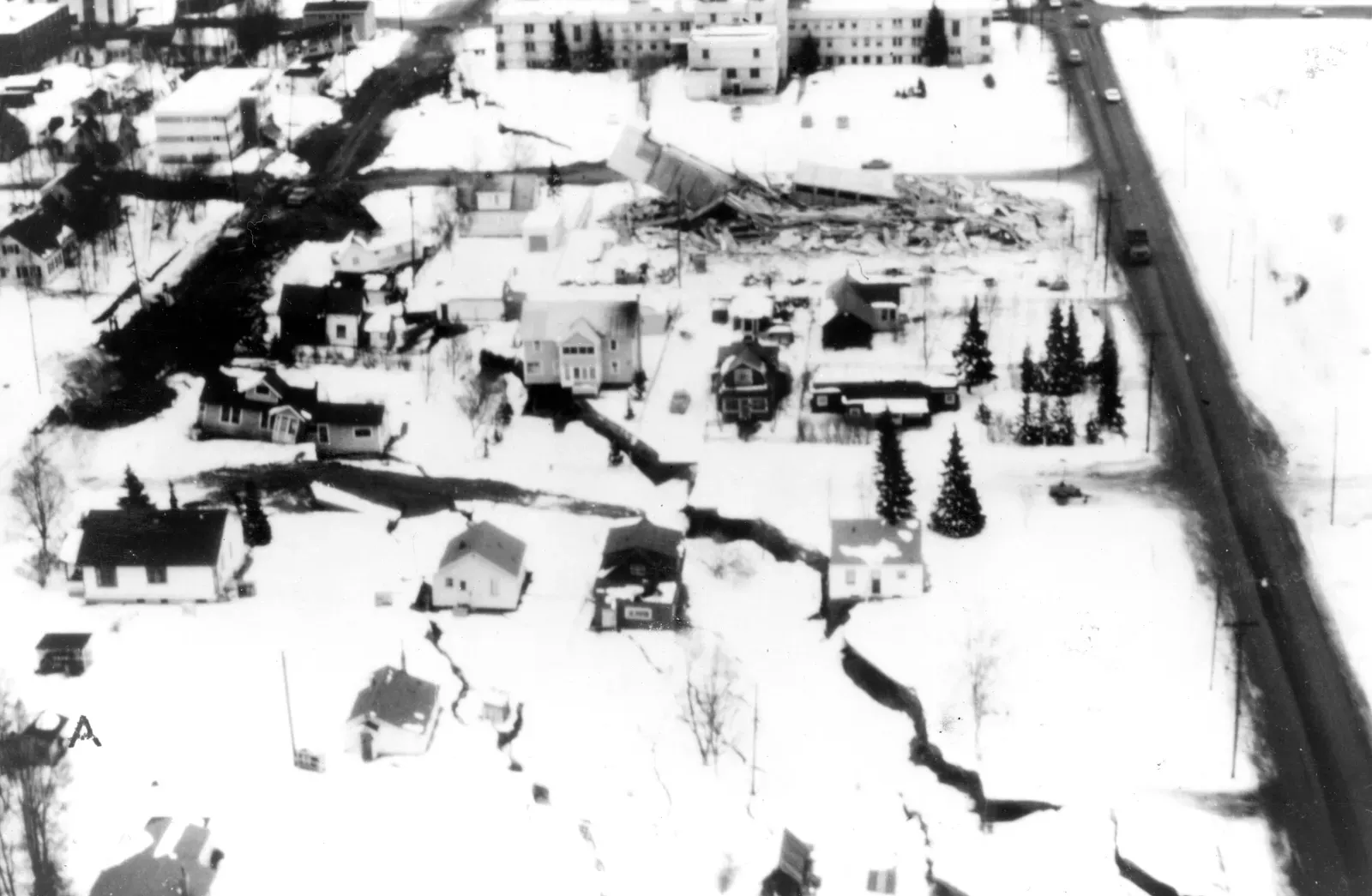
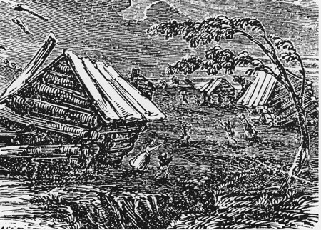
The 1964 Great Alaska Earthquake is still the heavyweight champion of U.S. quakes, a magnitude 9.2 monster that ripped through south‑central Alaska and reshaped everything from coastlines to science textbooks. Lasting roughly about four and a half minutes, it turned streets into rolling waves, dropped entire neighborhoods by several meters, and triggered massive submarine landslides that led to deadly tsunamis across the Pacific. For people who lived through it, the memory is less about numbers and more about a surreal, drawn‑out moment when solid earth behaved like liquid.
Scientifically, this quake changed the game. It was one of the first major events that strongly confirmed the then‑new theory of plate tectonics, showing in terrifying detail how the Pacific Plate dove beneath the North American Plate. Engineers studying the aftermath learned ugly lessons about soil liquefaction, lateral spreads, and how poorly built structures crumble when the shaking drags on. Modern seismic building codes in the United States, especially in high‑risk regions, trace many of their principles back to what Alaska’s broken ground taught us in 1964.
2. 1965 Rat Islands, Alaska (Magnitude 8.7)
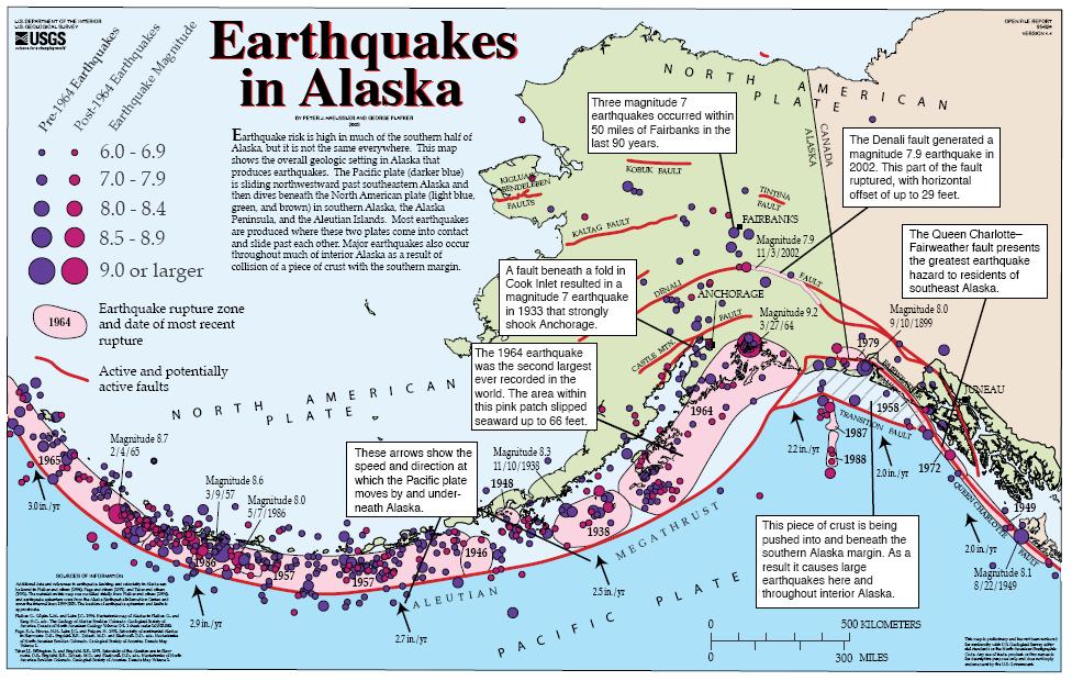
Just one year after the Great Alaska Earthquake, another giant struck far out in the Aleutian chain: the 1965 Rat Islands earthquake, with a magnitude of 8.7. Because it occurred in a remote, sparsely populated area, it did not dominate headlines in the same way, but on a purely geophysical level it was staggering. The rupture extended along a large portion of the plate boundary zone where the Pacific Plate grinds beneath the North American Plate, setting off tsunamis recorded across the Pacific basin.
What made the Rat Islands quake so important is how it helped seismologists map out the behavior of subduction zones that are mostly underwater and out of sight. By studying the pattern of aftershocks, tsunami records, and subtle changes in the seafloor, scientists pieced together a clearer picture of how energy builds and releases along the Aleutian arc. It was a powerful reminder that the lack of people in an area does not mean a lack of risk; it just means we rely more heavily on instruments, models, and deep‑ocean data buoys to understand what the crust is doing out there in the dark.
3. 1957 Andreanof Islands, Alaska (Magnitude 8.6)
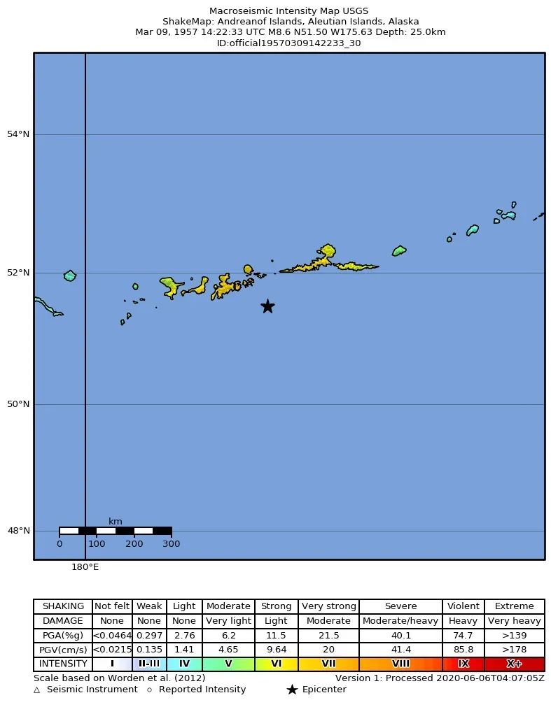
The 1957 Andreanof Islands earthquake, another giant in the Aleutian chain, reached a magnitude of about 8.6 and ruptured a long segment of the subduction zone. Coastal areas in Alaska saw significant damage, and the event generated tsunamis that were observed as far away as Hawaii and along parts of the West Coast. In a way, it was an early preview of the kind of subduction megathrust event that worries emergency planners today.
This quake taught researchers that great earthquakes in Alaska do not occur as one‑off flukes, but as part of a longer pattern along a complex plate boundary that can fail in large chunks. By cataloging how and where the fault ruptured, scientists began estimating recurrence intervals for major events in the region, a concept that now underpins seismic hazard maps. For coastal communities, the Andreanof quake also underscored that you do not need to feel strong shaking locally to be at risk from tsunamis generated somewhere else along the same plate boundary.
4. 1946 Aleutian Islands, Alaska (Magnitude 8.6)
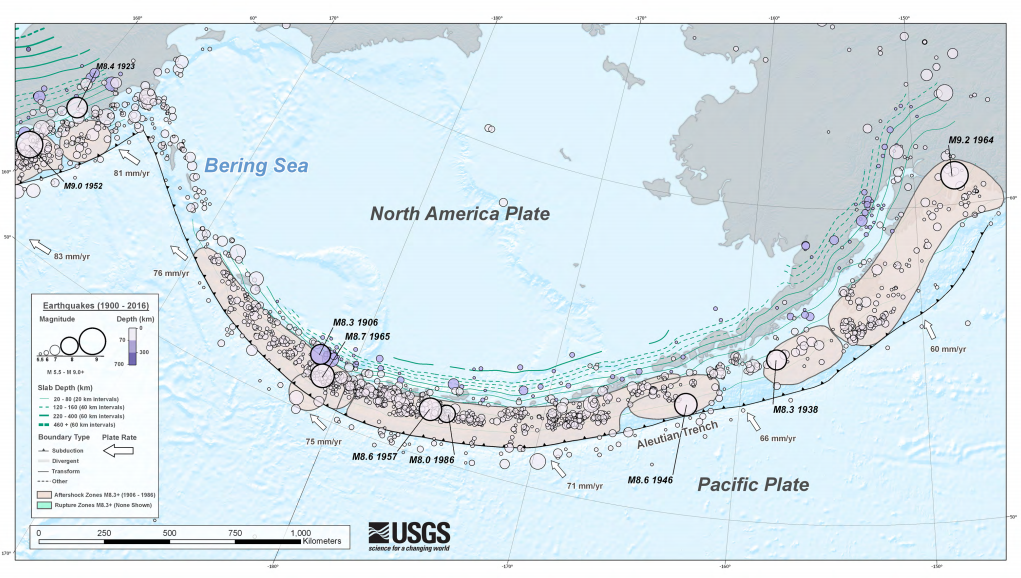
The 1946 Aleutian Islands earthquake reached about magnitude 8.6 and is infamous not just for its shaking, but for the devastating tsunami that followed. One of the striking features was that the local shaking in some areas did not seem extreme enough to match the size of the tsunami, leading to confusion at the time about what exactly had happened on the seafloor. The wave that slammed into parts of Hawaii, in particular, was far larger than early interpretations of the earthquake’s magnitude would have predicted.
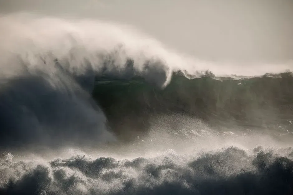
This event ended up pushing scientists toward a deeper understanding of so‑called tsunami earthquakes, where relatively slow fault rupture can generate an outsized tsunami compared with the felt shaking. It also played a key role in the creation and evolution of Pacific tsunami warning systems, as the loss of life highlighted how vulnerable distant coasts can be to events along the Aleutian subduction zone. In a sense, the 1946 quake taught coastal communities to take tsunami risk far more seriously, even when the earthquake itself seems remote or strangely modest.
5. 1938 Alaska Peninsula Earthquake (Magnitude 8.2)
The 1938 Alaska Peninsula earthquake, with a magnitude of roughly 8.2, struck another portion of the long and restless boundary between the Pacific and North American Plates. It generated a tsunami that traveled across the Pacific, but the event is less well known outside scientific circles, partly because the region was relatively remote and media coverage at the time was limited. Still, for geophysicists, it became a key data point in understanding how different segments of the same plate boundary fail at different times and in different ways.
One of the enduring lessons from 1938 is that the Alaska subduction zone is not a single, simple fault, but a patchwork of segments that can host large earthquakes separated by decades. When scientists today talk about “seismic gaps” – stretches of fault that have not ruptured in a long time and might be building stress – they often look back at events like this one to calibrate their models. It is a quiet but powerful reminder that some of the most important earthquakes for risk assessment are the ones ordinary people barely remember, but which live on in tide‑gauge records, seismograms, and revised hazard maps.
6. 2021 Alaska Peninsula Earthquake (Magnitude 8.2)
Jumping forward to the twenty‑first century, the 2021 Alaska Peninsula earthquake matched the 1938 event with a magnitude near 8.2, but it struck a world that was far better instrumented and far more prepared. High‑quality seismic networks, GPS stations, and tsunami warning systems quickly lit up as the rupture began, allowing agencies to issue alerts and monitor evolving conditions almost in real time. Despite its size, the quake ended up causing relatively limited damage and loss of life compared with historic giants, largely because of its offshore location and improved preparedness.
From a scientific point of view, the 2021 event offered a rare chance to watch a great earthquake unfold in an area where we already had a strong historical record, including the 1938 quake. Comparing the two has helped refine models of how stress transfers along the subduction zone and how repeated large events may or may not fully release accumulated strain. For the rest of us, it was a powerful demonstration that modern warning systems, better building practices, and public awareness can turn what might have been a catastrophe in another era into a serious but manageable event.
7. 1700 Cascadia Megathrust Earthquake (Estimated Magnitude ~9.0)
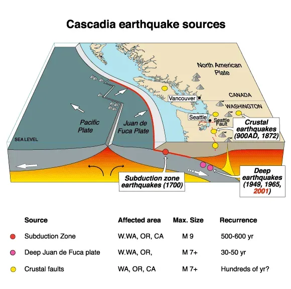
Long before modern instruments, an enormous earthquake struck the Pacific Northwest around January 1700 along the Cascadia subduction zone, with an estimated magnitude near 9.0. We know about it not because anyone in what is now the United States wrote it down, but thanks to a patchwork of Indigenous oral histories, coastal geology, drowned forests, and carefully matched tsunami records from Japan. The realization that a giant quake had silently reshaped the region centuries ago was one of the most unsettling scientific detective stories in North American geology.
The lesson from Cascadia is stark: just because a fault has been quiet in written history does not mean it is harmless. Today, the Cascadia subduction zone – from northern California through Oregon and Washington up into British Columbia – is recognized as capable of producing another megathrust event with shaking, tsunamis, and infrastructure damage on a scale that could rival or exceed some of Alaska’s worst quakes. This has transformed long‑term planning in the Pacific Northwest, from updating building codes to rethinking coastal evacuation routes and even how communities store fuel, food, and medical supplies for a disaster that could disrupt daily life for weeks or months.
8. 1811–1812 New Madrid Earthquakes, Central United States (Estimated Magnitudes ~7–8 Range)
When people picture U.S. earthquakes, they usually think about California or Alaska, not the flat heartland of the Mississippi Valley. That is exactly why the 1811–1812 New Madrid earthquakes are so haunting: a sequence of very large events, with estimated magnitudes in the high 7 range and possibly beyond, shook what is now Missouri, Arkansas, Tennessee, and nearby states. Reports from the time describe widespread ground deformation, sand blows, and landslides, along with strong shaking felt across a vast part of the country.
These quakes taught us that intraplate regions – the “middle” of tectonic plates, far from obvious boundaries – are not necessarily as quiet or safe as they seem. The New Madrid seismic zone is still active today, and there is ongoing debate about the likelihood and timing of future large events. The uncomfortable takeaway is that millions of people now live on ground that many still assume is nearly earthquake‑free, and yet the buried faults beneath the central United States clearly have a history of waking up in dramatic fashion.
9. 1906 San Francisco Earthquake, California (Magnitude ~7.8)
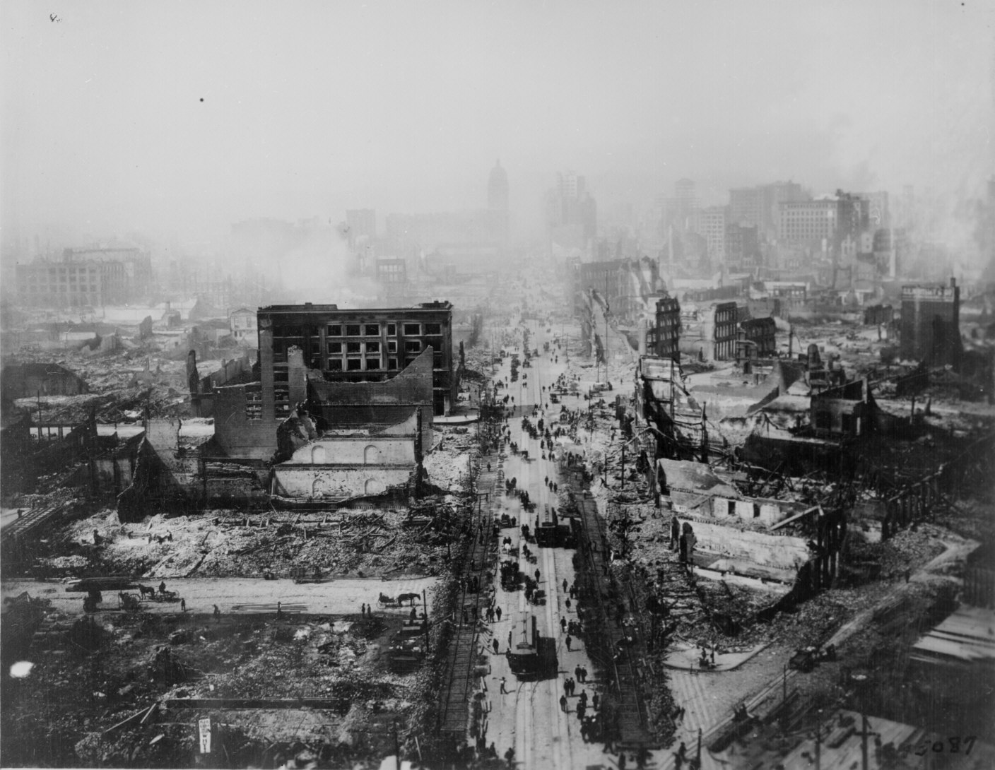
The 1906 San Francisco earthquake might not be the largest on this list by raw magnitude, but it is easily one of the most influential in terms of how Americans and the world think about earthquake risk. With a magnitude of roughly 7.8, it violently ruptured a long section of the San Andreas Fault and set off fires that raged through San Francisco, destroying large swaths of the city. It was a brutal demonstration of how a few tens of seconds of fault slip can translate into years of rebuilding and a permanent shift in a region’s history.
From a scientific and engineering perspective, 1906 became a template. Detailed field surveys of surface rupture and damage patterns helped cement the understanding that earthquakes are tied to sudden movement along faults, supporting what evolved into the elastic rebound theory. The event also highlighted how secondary effects – fire, broken water lines, collapsed infrastructure – can compound the initial damage. In many ways, modern seismic zoning, insurance models, and the way cities think about lifeline infrastructure owe an intellectual debt to what San Francisco’s streets and buildings revealed when the San Andreas snapped.
10. 1960 Valdivia–Pacific Basin Impact and U.S. Lessons from the World’s Largest Recorded Quake (Magnitude 9.5)
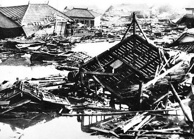
Technically, the 1960 Valdivia earthquake struck Chile, not the United States, but its global impact forced U.S. scientists and emergency planners to rethink their assumptions about the Pacific Ocean as one interconnected system. With a magnitude near 9.5, the largest instrumentally recorded earthquake on Earth sent tsunamis racing across the Pacific, including toward Hawaii, Alaska, and the West Coast. The waves caused serious damage and loss of life far from the epicenter, making it painfully clear that what happens along one subduction zone can threaten communities on entirely different continents.
For the United States, Valdivia became a brutal case study in why international data sharing, deep‑ocean instruments, and coordinated tsunami warning centers are not optional extras, but essential infrastructure. It accelerated efforts to better map seafloor topography, model wave propagation, and integrate warning messages into local emergency systems along American shores. In a way, the world’s biggest recorded earthquake turned the entire Pacific Rim into a single classroom, and the United States was forced to admit that its understanding of tsunami risk had been far too narrow and local.
Conclusion: The Ground Is Restless, But Our Choices Matter
Looking across these earthquakes, what stands out to me is not just the raw power of the planet, but how stubbornly we keep underestimating it. Again and again, huge events have forced us to admit that our mental maps were too simple: fault zones are longer than we thought, quiet regions are not always safe, and the ocean is a ruthless messenger that carries the consequences of distant ruptures to our own shores. If anything, the historical record is a loud, unambiguous warning that the next big surprise is less a question of if and more a question of when and where.
At the same time, these quakes prove that our choices change outcomes. Better building codes, smarter land‑use planning, tsunami education in coastal schools, and genuinely funded emergency systems have already turned some potential disasters into survivable shocks. Personally, I think the most dangerous myth is not that earthquakes are rare, but that there is nothing we can do about them; history shows that is simply wrong. The ground beneath us will stay restless, but whether the next big quake becomes a tragedy or a hard‑earned success story depends on what we decide to build – and believe – right now. So, when you picture the next great earthquake, do you picture helplessness, or preparation?