You grow up being told that lakes are peaceful places: glassy water, fishing at dawn, families in kayaks. Nobody tells you that some of those lakes are actually graveyards, hiding whole communities under the surface. Yet all over the world, towns were deliberately drowned in the mid‑twentieth century to make way for reservoirs, and now, as water levels drop, those places are starting to climb back into the light.
When you stand on a cracked shoreline and see old roads heading straight into the water, or a stone foundation where a boat ramp should be, it hits you: this used to be somebody’s front yard. The year 1958 sits right in the middle of the hydroelectric dam boom, when engineers and planners were obsessed with taming rivers and banking water for the future. Decades later, climate extremes are tugging those decisions back into view, and you are being forced to look directly at what was buried to keep taps running and lights on.
The Day the Town Sank Beneath the Water
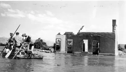
Imagine it’s the late 1950s and officials tell you that your hometown is going to disappear, not metaphorically but literally. The valley you know by heart will be flooded, the church steeple you use to orient yourself will become a hazard to boat traffic, and your grandparents’ graves will either be moved or left to the water. For many communities in that era, including places that were still being cleared and condemned in 1958, that was not a hypothetical; it was official policy in the name of progress. You did not get to vote on whether your memories were worth more than megawatts.
The story usually followed a grimly familiar script. Crews would move in, catalog homes, sometimes dig up cemeteries and truck the remains to higher ground, strip trees, knock down or burn buildings, and then walk away as the dam gates closed. Within months, a river that had flowed for thousands of years would back up into a reservoir, and your town would sink street by street. On paper, it became a line item in a water‑supply plan; in reality, it became an underwater time capsule, sealed away with everything people could not carry out in pickup trucks and cardboard boxes.
When the Water Backs Away and the Ghost Map Reappears
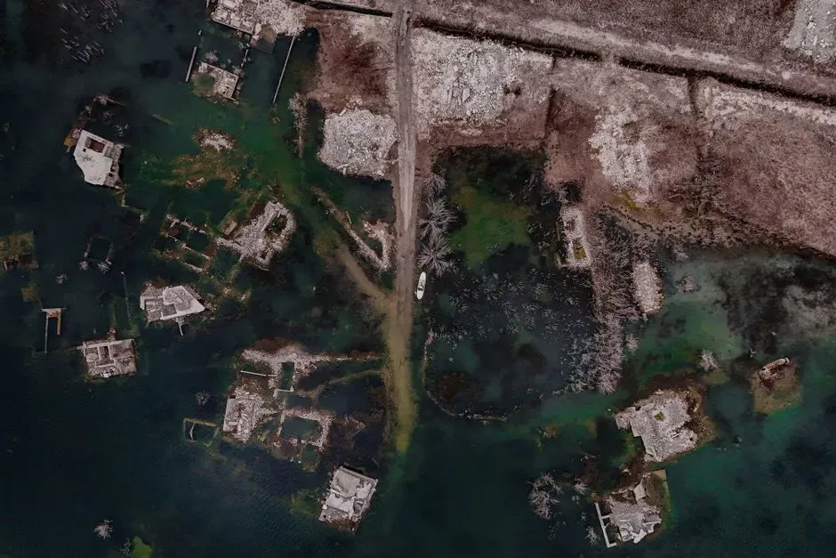
Fast‑forward to today, when droughts, shifting rainfall, and heavy water use are dragging many reservoirs to levels their designers never expected. You start to see strange shapes emerging at the margins: an old bridge span, a row of fence posts, the carved steps of a church that no one has walked up in half a century. In some lakes, whole town grids have reappeared – streets you can trace with your eyes from shore to shore, the bones of houses sitting in the mud, and foundations that match the old maps almost perfectly. It looks like a ghost map being printed right on the cracked reservoir floor.
As water retreats, you are forced into an uncomfortable double vision. On the one hand, this exposed ground is a warning about water scarcity and hotter, drier climates. On the other, it is a revelation, showing you the consequences of decisions your grandparents’ generation made about who and what could be flooded for the “greater good.” In some places, visitors pick through bricks and broken dishes, treating it like a curiosity; in others, descendants return to where their living rooms once stood and find themselves crying in the dust. The reservoir stops being just infrastructure and turns into an exposed nerve of history.
Bodies, Barrels, and the Dark Side of Deep Water
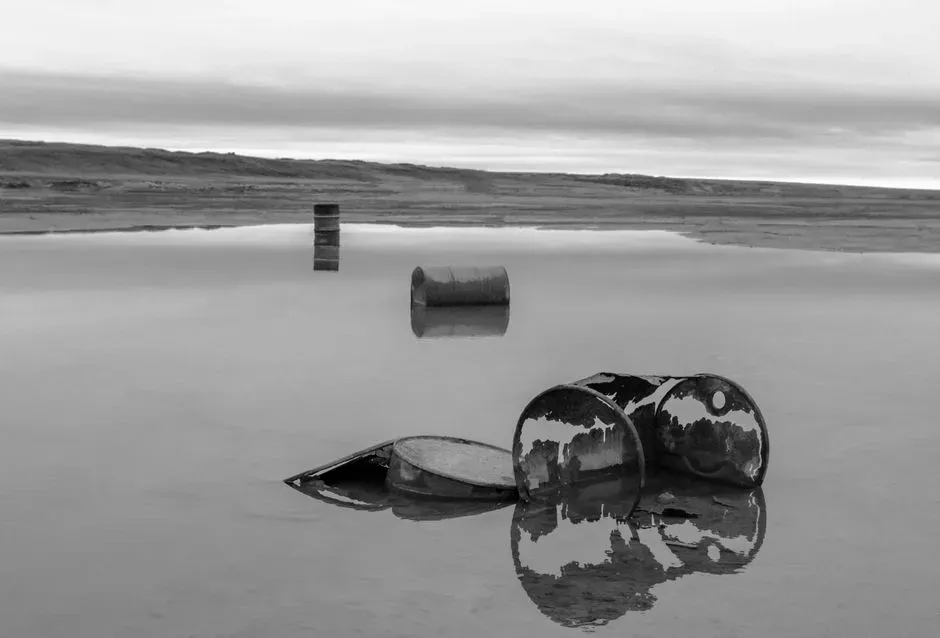
When a reservoir drops far enough, you do not just get pretty stone ruins and old bridges; sometimes you get the parts of the past everyone tried to forget. Lowered water has already revealed multiple sets of human remains in large Western reservoirs, including people who vanished in boating accidents in the 1950s and 1960s and were never recovered. One man who went missing in 1958 was finally found decades later when water levels had fallen enough to expose the wreckage containing his remains. It is a grim reminder that, for a long time, deep water was treated as a final hiding place.
And it is not only accidents that resurface. In some lakes near big cities, drying shorelines have exposed rusted barrels and other suspicious debris that investigators suspect could be tied to organized crime and unsolved killings from the early days of nearby boomtowns. You might have grown up thinking of those places as weekend playgrounds, only to discover they were also convenient dumping grounds when no one was watching. Each newly exposed barrel or vehicle pulls an old cold case out of hibernation, and you get a front‑row seat to the reality that water can bury secrets, but it does not erase them.
The Archaeological Gold Mine You Didn’t Expect
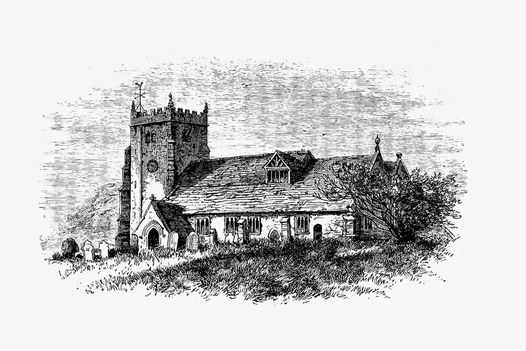
It is easy to forget that before these reservoirs were built, river valleys were some of the best places on earth for people to live, which means they are often layered with centuries of history. When water pulls back, you are not just looking at mid‑century gas stations and farmhouses; you are sometimes staring at medieval churches, Indigenous village sites, or even the remains of ancient cities. In Spain and Mexico, prolonged drought has brought stone churches from the sixteenth and seventeenth centuries back into daylight, their arches and bell towers still hauntingly intact after decades underwater.
Elsewhere, sinking water levels have exposed the outlines of old Indigenous settlements and long‑buried fields, giving archaeologists a fleeting window to document structures, gather artifacts, and map patterns of life that vanished when the dam gates closed. You, as a visitor, might just see tumbled rock and broken pottery, but to researchers, this is a gold mine – and an ethical dilemma. Every extra step you take across that cracked mud risks damaging something irreplaceable, and in many cases, they have only weeks to record it before the rains return and the lake swallows everything all over again.
What Happens to a Drowned Place After Decades Underwater
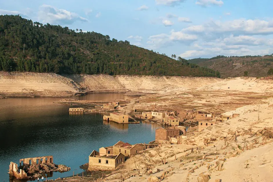
If you walk across an exposed town site, you might be surprised by what survived and what did not. Wood rots quickly, fabrics vanish, and anything light enough to float is long gone, but stone, concrete, and metal tend to endure, especially if they were buried in sediment. Even underwater, roads can stay recognizable, cellar walls can stand waist‑high, and heavy machinery can sit more or less where it was abandoned in the 1950s. In some reservoirs, engineers even left taller structures like church towers and grain silos intact, assuming they would never be seen again.
Decades of immersion have also changed these places in subtle ways you might not notice at first glance. Algae and freshwater mussels leave a thin crust on surfaces, fish and aquatic plants thread their way through foundations, and successive layers of silt partially entomb whatever was on the valley floor. When water finally recedes, these growths dry and flake away, but the staining remains, like tide marks on a bathtub that show you exactly where the reservoir hovered for years. The result is eerie: a town that looks both frozen in time and clearly marked by the long, slow touch of water.
Your Memory, Their Sacrifice, and the Next Time the Water Rises
Standing on the exposed floor of a “lost” town, you cannot avoid the question of who paid the highest price for all that stored water and hydropower. Many communities displaced in the 1950s and late 1940s were rural, politically weak, or Indigenous, which made it easier for planners to declare them expendable. When you see their streets and foundations again, it becomes harder to pretend those were painless trade‑offs. You are not just looking at rocks; you are looking at the physical proof that some people’s homes and histories were treated as the acceptable cost of keeping distant cities safe and supplied.
The irony is that the same climate shifts now exposing these drowned places are also making dependable water storage more important than ever. You live in a time of hard choices, where draining or downsizing a problematic reservoir might reveal priceless heritage and reduce ecological harm, but keeping it full may be the only way to survive the next brutal drought. As more “ghost towns” reappear along shrinking shorelines, you are being asked to decide what lessons to take from them: that you should build better, plan more fairly, or perhaps stop assuming that burying something beneath a reservoir means it is gone for good.
In the end, the reservoir that swallowed a town in 1958 and is finally giving it back is not just a curiosity; it is a mirror. It reflects what earlier generations were willing to flood, what you are willing to remember, and how far you are prepared to go to keep the taps on without erasing entire communities again. The next time you stand on the edge of a glittering man‑made lake, will you picture only the surface, or will you let yourself imagine the streets, stories, and sacrifices lying just out of sight beneath your feet?