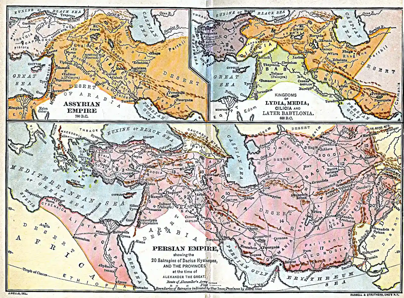
Archaeology is supposed to move slowly, one trowel scrape at a time, yet some of the most disruptive discoveries of the past few decades have appeared where nobody thought to look: under suburbs, beneath jungle canopies, below busy streets, and even inside construction pits. Again and again, “lost cities” have surfaced in places assumed to be fully mapped or utterly uninhabitable. These finds do more than add new dots on an ancient map; they overturn what we thought we knew about population, power, and how civilizations adapt to extreme environments. Here are ten cases where forgotten urban worlds emerged from wildly unexpected settings – and forced researchers to rethink the deep human past.
A Maya Metropolis Hiding in Plain Sight Under the Mexican Jungle
When archaeologists announced the discovery of a sprawling Maya city called Valeriana in the jungles of Campeche in southern Mexico, the shock was not just its size, but the fact that the evidence had been sitting in remote-sensing data for years. The city came into focus thanks to lidar, an airborne laser-scanning method that strips away the digital forest canopy and reveals the geometry of buildings and roads beneath. What looked like uniform green jungle on satellite images turned out to be a dense urban landscape, with thousands of structures mapped across more than a hundred square kilometers.
Valeriana’s plazas, temples, and terraced fields show that this was not a minor outpost; it was a major Classic-period Maya center with an unexpectedly high population density. The distribution of buildings suggests careful planning, with causeways and water-management systems threading through the forested terrain. For decades, scholars assumed that lowland Maya cities were relatively isolated and scattered; now, researchers are realizing they may have been linked in continuous belts of settlement. The jungle, once imagined as an empty backdrop, is turning out to be more like a buried circuit board for a lost civilization.
Laser-Ghost Cities in the Honduran Mosquitia Rainforest
In eastern Honduras, the Mosquitia rainforest was long treated as a blank space on archaeological maps, spiced only with legends of a “White City” hidden in the clouds of insects and humidity. That changed when an airborne lidar survey in 2012 lit up the landscape with rectilinear patterns that screamed architecture, not geology. Ground expeditions soon confirmed that at least one valley contained plazas, earthwork pyramids, and a cache of stone sculptures, including human–animal figures that hint at a rich, unfamiliar religious world. The site appeared untouched for centuries, with jungle wildlife behaving as if humans were an alien invasion.
What made this discovery so unexpected was less the idea of a lost city and more the realization that there may be several such centers in a region once thought marginal. The Mosquitia settlements seem to date to roughly the last centuries before European contact, and do not match known Mesoamerican polities, pointing to a distinct cultural tradition that had barely been documented. For archaeologists, it was like turning a corner and finding an entire chapter of history that had been ripped from the textbook. And again, the hero of the story was not a machete-wielding explorer, but an aircraft firing invisible laser pulses through the canopy.
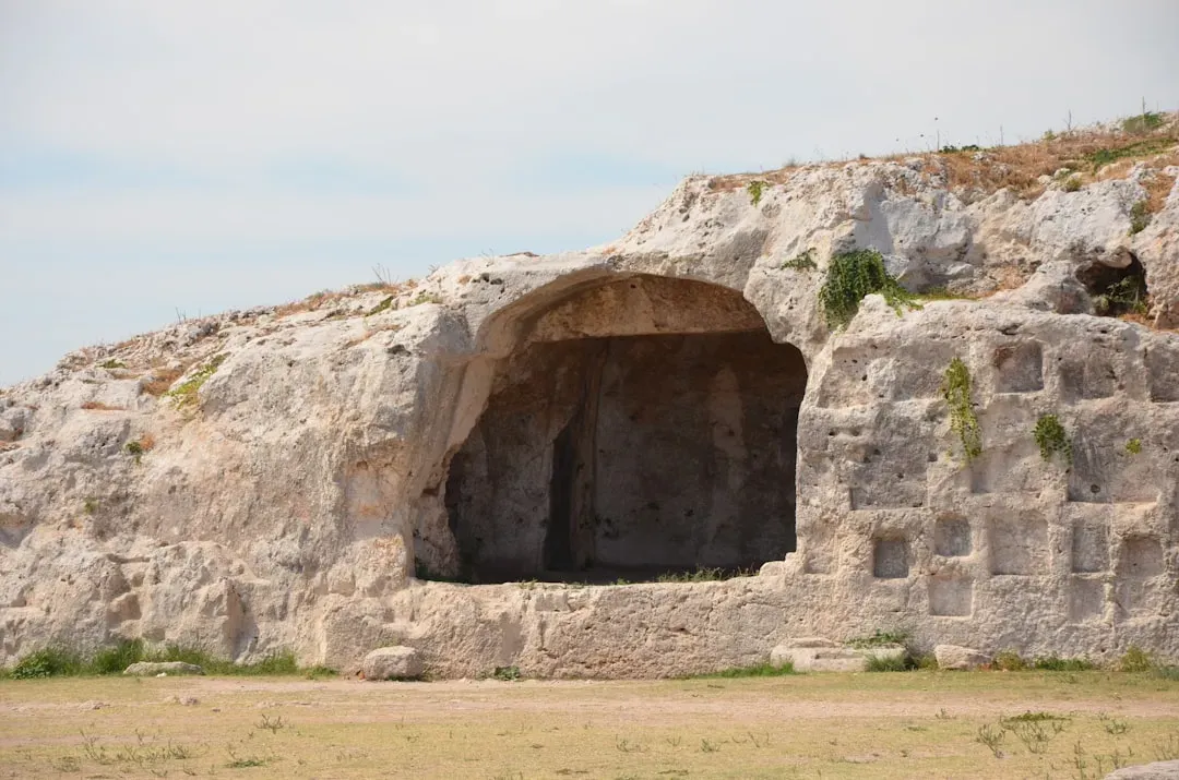
Pavlopetri: A Bronze Age Port City Beneath Shallow Greek Waters
If you picture a “lost city,” you might think of deep-ocean ruins straight out of a myth, not a town lying just a few meters underwater off a tourist beach in southern Greece. Yet Pavlopetri, off the coast of Laconia near Elafonisos, is considered one of the oldest known submerged cities in the world, with origins going back roughly five millennia. Mapped in detail by archaeologists in the late 1960s and revisited with digital tools in the twenty-first century, the site preserves streets, building foundations, and tombs that look eerily like a modern seaside town pressed into the seafloor.
The surprise here is how ordinary and how vulnerable Pavlopetri is. You can stand on the nearby shore and see the outline of this Bronze Age port beneath clear water, a reminder that rising seas and coastal subsidence have been erasing urban coastlines for millennia. The city’s preservation gives researchers a rare, almost blueprint-like view of early urban planning in the Aegean world, including room layouts and traffic lanes. It also drives home an uncomfortable parallel with our own moment of accelerating sea-level rise: ancient people built right up against a changing shoreline, and sometimes the ocean simply took their cities back.
Thessaloniki’s Roman Avenue and Market Under a Modern Metro Station
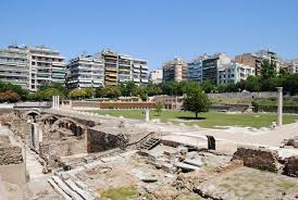
In Thessaloniki, Greece’s second city, commuters stepping into the new Venizelou metro station are also stepping onto the footprint of an ancient downtown. During construction, engineers hit not rubble, but an almost intact stretch of the Roman and Byzantine-era decumanus – the main east–west street – running beneath today’s Egnatia Avenue. Shops, workshops, public spaces, even sections of a public square emerged from beneath the asphalt, so continuous that archaeologists dubbed it a “city under the city.” Instead of simply removing the remains, planners eventually chose the more radical path: build the station around an open archaeological site.
The result is something that would have sounded like science fiction a generation ago – a working underground transit hub where, one level up, you can look across preserved city blocks that buzzed with life more than a thousand years ago. This discovery did not reveal an unknown civilization, but it radically changed the public’s sense of Thessaloniki’s depth in time. It also forced a rethink of how modern infrastructure projects interact with buried heritage. Rather than history being sacrificed for progress, the station has become a case study in layering the two, making ancient urbanism part of the everyday commute.
Working-Class Rome Discovered Beneath a Future Metro Stop

Rome is famously an archaeological minefield, yet even by Roman standards, what emerged at Piazza Venezia during the new Metro C excavations caught experts off guard. Deep beneath the traffic-clogged square, archaeologists uncovered multistorey dwellings and shops dating to the transition from the late Republic to the early Empire, a slice of working-class life lodged at the very heart of monumental Rome. These were not palaces or forums, but practical, crowded buildings where artisans and small traders lived above their businesses, stacked into the urban fabric like vertical villages.
For a long time, the Piazza Venezia area was framed mostly through its imperial monuments and modern nationalist architecture. The discovery of these more modest structures exposed the social layers usually edited out of postcard views. Plans now call for an underground museum wrapped into the metro station, turning construction delays into an educational asset. The find rewrites the mental map of central Rome from a space dominated solely by emperors, generals, and popes into a neighborhood where thousands of ordinary people navigated noise, smells, and economic hustle not so different from a modern city block.
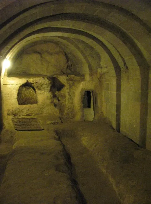
Turkey’s Underground Cities Lurking Beneath Town Streets
In northeastern Turkey’s Bayburt Province, the Aydıntepe underground city is a reminder that sometimes the most astonishing lost settlements are not beneath jungles or seas, but literally under people’s homes. Discovered in the late twentieth century during construction work in a modern town, the complex consists of roughly a kilometer of tunnels, chambers, and shafts carved into soft volcanic rock several meters below ground. Narrow passageways connect larger rooms and storage areas, with conical ventilation shafts piercing up toward the contemporary neighborhood above.
Archaeological evidence suggests the system was in use for around three thousand years, spanning from at least the late Roman or early Byzantine periods and repurposed by different religious communities as a refuge during times of persecution or war. The very ordinariness of the surface settlement makes the hidden city feel surreal; it is as if a second, secret town had been slotted under the first. Together with other underground cities in central Anatolia, Aydıntepe shows how residents of volatile frontier zones engineered three-dimensional security systems, turning the earth itself into an architecture of survival.
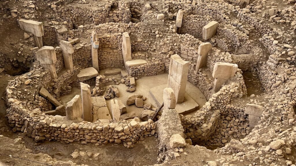
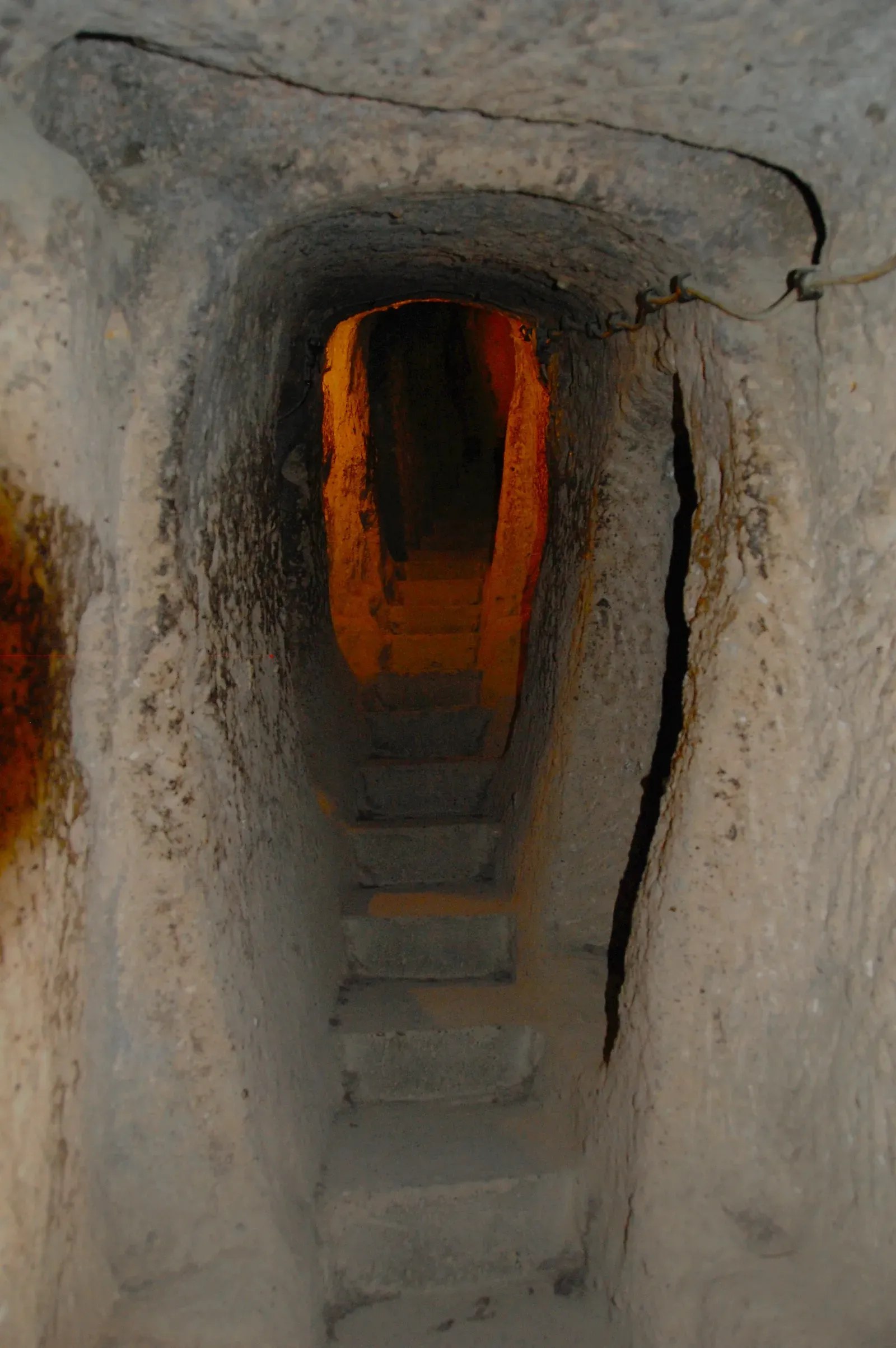
Derinkuyu and Özkonak: Vertical Cities Engineered for Siege
Cappadocia’s rock-cut underground cities, notably Derinkuyu and Özkonak, are so extensive that early visitors struggled to believe they were not embellished legends. Derinkuyu plunges many levels beneath the surface, with spaces large enough to host churches, wineries, and stables, all ventilated by deep shafts that double as lifelines and chimneys. Özkonak, discovered in the 1970s when a farmer investigated where his irrigation water was disappearing, adds another twist: a network of carved communication pipes linking rooms and levels, so people could coordinate while sealed inside during an attack.
What makes these sites fit the theme of “unexpected places” is the way they invert the normal idea of a city. Instead of walls rising into the sky, the defenses drop downward, with rolling stone doors designed to be slammed shut from within, transforming corridors into dead ends for invaders. These settlements were not just temporary hideouts; they were fully equipped to sustain communities for long stretches, with storage, water sources, and careful ventilation. In a region where empires and armies repeatedly crashed through, inhabitants effectively opted out of the arms race on the surface, building entire hidden worlds below the tourist-friendly fairy chimneys.
An Analytical Look: How “Lost Cities” Are Changing Archaeology Itself
Seen together, these discoveries mark more than a series of headline-grabbing finds; they amount to a quiet revolution in how archaeology works and what questions it can ask. Technologies like lidar and high-resolution geophysics have shifted the discipline from pointillist digs to landscape-scale mapping, revealing that many so-called “ceremonial centers” in forested or marginal areas were actually embedded in densely settled urban networks. Early models often imagined ancient cities as islands of complexity in seas of wilderness; the new data shows webs of roads, terraces, and satellite communities instead.
Equally important is the way modern infrastructure – metros, pipelines, housing – has unintentionally become a driver of discovery, forcing archaeologists to rethink how they collaborate with engineers and planners. Instead of simply rescuing artifacts before bulldozers arrive, teams now lobby for designs that preserve and present significant finds in situ, as in Thessaloniki and Rome. Culturally, the pattern of “cities under cities” and “towns under towns” complicates tidy stories of rise and fall, suggesting that urban landscapes are palimpsests where each era writes over, but never fully erases, its predecessors. For students and researchers alike, the big shift is from asking where cities existed to asking how many more might still be hiding in data we have already collected.
Unfinished Maps: What These Cities Still Keep Secret
As dramatic as these rediscoveries are, they come with a humbling message: our picture of the ancient world is still radically incomplete. Sites like Valeriana in Mexico and the Mosquitia valleys in Honduras were first glimpsed years before anyone could trek in to verify what the laser data suggested, and large portions remain only lightly ground-truthed. In underwater and underground contexts, the technical challenges of excavation and conservation are even more severe. Every new trench risks damaging delicate structures; every visitor center adds stress to environments that survived precisely because they were ignored.
At the same time, these places sharpen debates about whose history gets told and funded. Working-class neighborhoods under Rome’s piazzas, or multi-faith refuge systems under Anatolian towns, highlight communities often overshadowed by royal courts and war chronicles. Future work will likely focus less on singular “lost cities” and more on regional systems: how ports like Pavlopetri plugged into Bronze Age trade, or how underground networks in Turkey connected across valleys and plateaus. The unresolved question hanging over all of this is not whether there are more cities to find – there almost certainly are – but whether we will recognize them fast enough, and protect them well enough, before modern pressures erase them a second time.
From Spectacle to Stewardship: How Readers Can Respond
It’s easy to treat lost-city stories as pure spectacle – jungle temples and sunken streets made for a streaming documentary binge – but they are also fragile scientific resources and, more importantly, parts of living communities’ heritage. One of the simplest things anyone can do is pay attention to how development and tourism are managed in archaeologically rich areas, and to support policies and organizations that prioritize careful conservation over quick profit. Visiting sites responsibly, whether that is an underwater ruin off a Greek beach or an underground city in Turkey, means respecting access rules, avoiding looting temptations, and recognizing that the most Instagrammable angle is not worth a broken wall.
On a more everyday level, staying curious matters. Following archaeological research through museum websites, university press releases, or science outlets keeps public pressure on governments to treat new finds as assets, not obstacles, when tunnels or highways cut into the past. Many digs now rely on interdisciplinary teams, from climate scientists to digital modelers, and they often share open data and virtual tours that anyone with an internet connection can explore. The next time you walk across a city square, ride a subway, or hike through “empty” countryside, it is worth wondering what other streets, homes, and stories might be layered just out of sight beneath your feet.

Suhail Ahmed is a passionate digital professional and nature enthusiast with over 8 years of experience in content strategy, SEO, web development, and digital operations. Alongside his freelance journey, Suhail actively contributes to nature and wildlife platforms like Discover Wildlife, where he channels his curiosity for the planet into engaging, educational storytelling.
With a strong background in managing digital ecosystems — from ecommerce stores and WordPress websites to social media and automation — Suhail merges technical precision with creative insight. His content reflects a rare balance: SEO-friendly yet deeply human, data-informed yet emotionally resonant.
Driven by a love for discovery and storytelling, Suhail believes in using digital platforms to amplify causes that matter — especially those protecting Earth’s biodiversity and inspiring sustainable living. Whether he’s managing online projects or crafting wildlife content, his goal remains the same: to inform, inspire, and leave a positive digital footprint.