For more than a century, the Egyptian pyramids have soaked up most of the spotlight, but archaeologists will quietly admit that some of the strangest mysteries lie far from Giza’s famous skyline. Scattered across coasts, deserts, volcanic plateaus, and highland fields are massive stone structures that often predate the pyramids, were built with fewer obvious political motives, and leave behind almost no written explanation. In many cases we can date them, map them, and even reconstruct how they might have been built, yet the most basic questions – who coordinated them, why these specific locations, and what myths once wrapped around them – remain stubbornly open. That combination of hard stone and soft uncertainty has turned these sites into laboratories for new science, from advanced dating techniques to ancient DNA and climate reconstructions. What is emerging is a more complex, global story of early engineering and belief systems than anything in the old textbook timelines.
Göbekli Tepe, Türkiye: Rewriting the Origin Story of Civilization
Perched above the plains of southeastern Türkiye, Göbekli Tepe looks at first like a chaotic tangle of broken stone, but under that rubble sits one of the most disruptive discoveries in modern archaeology. The site’s T‑shaped pillars, some weighing many tons and carved with reliefs of animals and abstract symbols, have been reliably dated to around eleven and a half thousand years ago – roughly twice as old as Stonehenge and older than any known large-scale agriculture in the region. That chronology flips a long-held assumption that farming created the stable communities needed for monumental building; instead, it now appears that people may have gathered for ritual first and organized food production later to support those gatherings. Excavations suggest repeated construction phases, with older enclosures deliberately buried under newer ones like a sequence of ritual resets. The deliberate backfilling, combined with the effort invested in carving and transporting the pillars, hints at complex social leadership and shared beliefs for which we have no surviving narrative.
Scientific work at Göbekli Tepe has become a test-bed for modern methods. Radiocarbon dating of charcoal and animal bones, microscopic wear analysis on stone tools, and isotopic studies of faunal remains all point to mobile hunter-gatherers converging on the site from a wider region, rather than a settled farming village. Remote sensing and ground-penetrating radar have revealed dozens of still-buried enclosures, suggesting that what we see now is only a fraction of the original complex. At the same time, the absence of domestic plant remains in early layers raises uncomfortable questions about how these people coordinated labor for such intense projects without the surplus we usually associate with cities. Archaeologists now talk about Göbekli Tepe less as an isolated marvel and more as a signal that our timeline for social complexity in the early Holocene is badly overdue for revision.
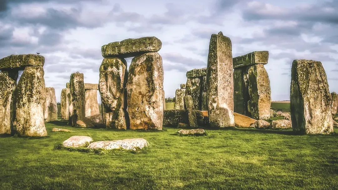
Stonehenge, England: A Prehistoric Observatory With a Mobile Past
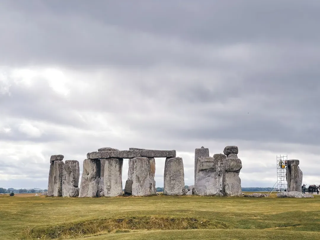
Stonehenge is often treated as the poster child for ancient mystery, but recent research has made its story both clearer and stranger. The familiar circle of sarsen stones is only one phase in a long-lived landscape of ditches, timber posts, burial mounds, and processional avenues that evolved over more than a thousand years. The famous alignments with the summer solstice sunrise and winter solstice sunset are real, yet they are only part of a broader choreography that connected Stonehenge to nearby sites like Durrington Walls. Isotopic analysis of animal bones found in feasting pits suggests that people traveled to the area from distant parts of Britain, leading some researchers to describe it as a seasonal pilgrimage center. That paints a picture of Stonehenge not as a static monument, but as the focal point of recurring gatherings, ceremonies, and maybe even political negotiations.
What has turned Stonehenge from a puzzle into a scientific case study is the multi-disciplinary toolkit now aimed at it. In the last decade, researchers traced some of the smaller bluestones to quarries in western Wales, more than a hundred miles away, indicating a truly ambitious transport effort long before wheeled vehicles were common in Britain. Analyses of cremated human remains show that some of the dead buried there also came from western Wales, hinting that the stones might have carried ancestral meaning along with their physical bulk. Massive geophysical surveys of the surrounding landscape have revealed previously unknown features, including ring ditches and anomalies that suggest other, lost timber circles. Despite all that data, the core question – why this combination of stones, astronomy, and long-distance mobility mattered so much to its builders – remains unresolved, keeping Stonehenge at the intersection of hard evidence and soft speculation.
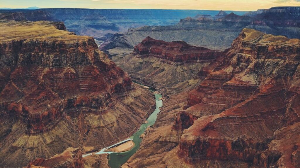
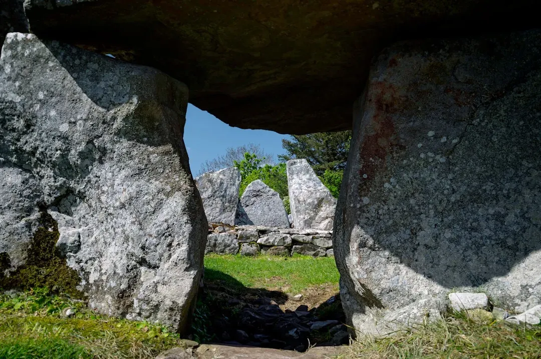
Sacsayhuamán, Peru: Polygonal Walls That Shrug Off Earthquakes
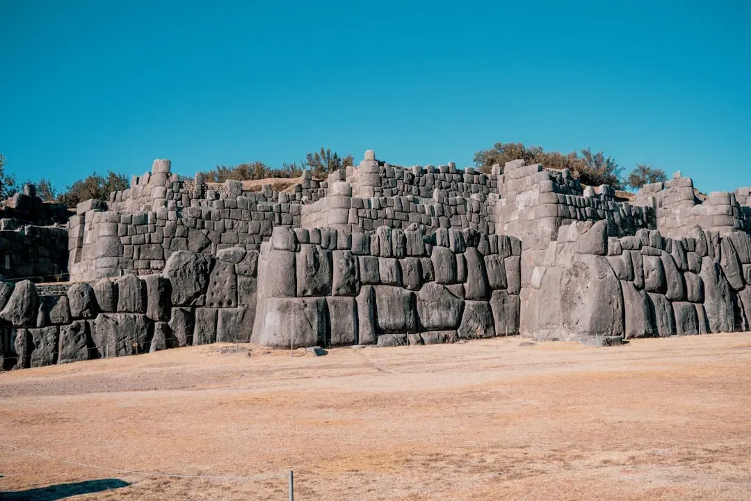
Above the modern city of Cusco, the Inca fortress-temple complex of Sacsayhuamán looks almost impossible at first glance. Its colossal zigzag walls are made of andesite blocks, some weighing as much as several dozen tons, cut into irregular polygons that interlock with astonishing precision. No mortar holds them together, yet the joints are so tight that thin blades can barely slide between the stones, and the structure has survived centuries of intense Andean earthquakes that have toppled much younger colonial buildings nearby. Spanish chroniclers in the sixteenth century described the walls with a mix of awe and fear, but left frustratingly few details about how they were built, and the Inca themselves did not leave technical manuals. Experiments with replica blocks, ramps, and ropes suggest plausible methods, but a fully tested reconstruction remains elusive at this scale.
Modern studies of Sacsayhuamán focus as much on engineering as on symbolism. Geological analysis has mapped quarries several kilometers away, where unfinished blocks and carved remains show that the stones were roughly shaped before transport. Structural engineers point out that the irregular polygonal design acts like a three-dimensional puzzle that dissipates seismic energy rather than concentrating it along straight fault-like joints. At the same time, archaeologists emphasize that Sacsayhuamán was more than a military installation; its plazas, ritual features, and elevated views over Cusco mark it as a node of imperial ceremony. The mystery is less whether the Inca could move big stones – they clearly could – and more how they coordinated skilled labor, encoded technical know-how, and integrated all of that into a worldview where stone itself was animated and sacred.
Newgrange, Ireland: A Neolithic Time Capsule of Light and Bones
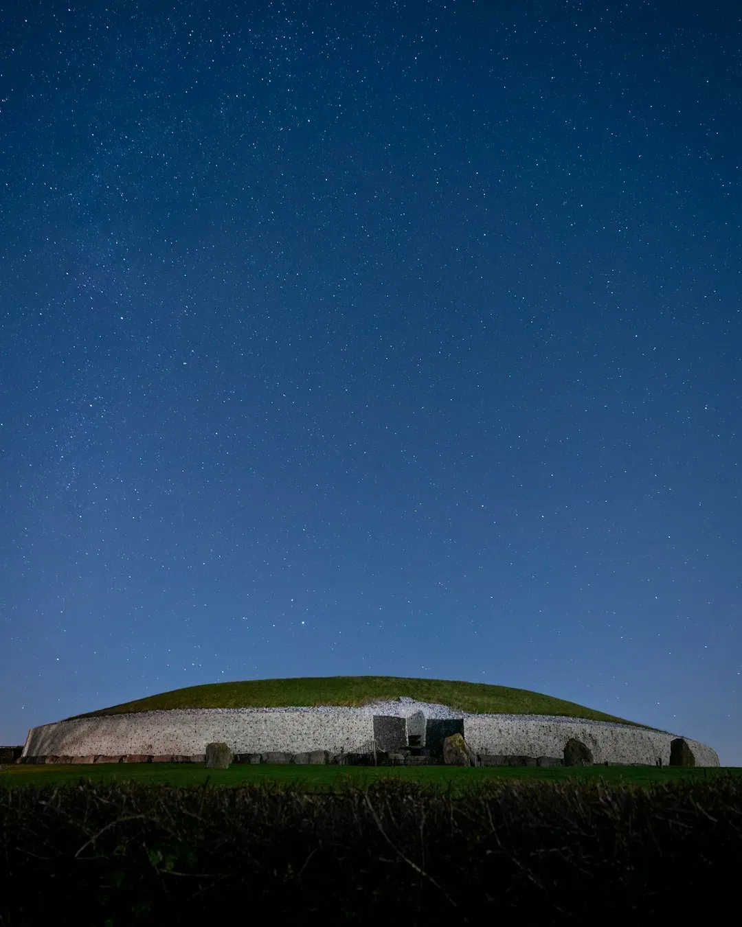
From the outside, Newgrange in Ireland’s Boyne Valley can look deceptively simple: a rounded mound faced with white quartz, ringed by large kerbstones. Inside, however, a narrow passage leads to a cruciform chamber whose alignment does something remarkable. On a few mornings around the winter solstice, if the weather cooperates, a shaft of sunlight enters through a roofbox above the doorway and travels down the passage to illuminate the chamber’s central recess. Archaeological dating places Newgrange at over five thousand years old, older than the Great Pyramid at Giza, which means this light show is the product of very early astronomical observation and architectural planning. The tomb also once held human remains, mingling the drama of cosmic illumination with the intimate presence of the dead.
Newgrange has become a textbook example of how megalithic monuments can embody both ritual performance and surprisingly precise engineering. Detailed surveys have shown that the monument is part of a wider ritual landscape featuring other passage tombs, henges, and standing stones, suggesting that winter solstice ceremonies may have involved processions and multi-stage rites. Genetic analysis of remains from the site revealed close kin relationships and, in one striking case from a nearby tomb, evidence of elite inbreeding, hinting at powerful lineages controlling access to these sacred spaces. Conservation work and 3D laser scanning have allowed researchers to model how the solstice light would have appeared when the structure was newly built, likely even more intense than today. Yet questions about how broad the community was that participated in these events – and how much of the monument’s meaning was restricted to an inner circle – continue to animate debates among prehistorians.
Nan Madol, Micronesia: A Coral and Basalt City on the Sea

On the island of Pohnpei in Micronesia, Nan Madol spreads across a lagoon like a shattered basalt chessboard. More than ninety artificial islets, built from stacked prismatic basalt columns and coral fill, form a network of narrow canals that once linked ritual, residential, and burial complexes. Oral traditions remember Nan Madol as a center of chiefly power and sorcery, yet archaeological surveys indicate that the most intensive construction took place between roughly the twelfth and seventeenth centuries, much later than many Old World megaliths. What makes it mysterious is not extreme age but sheer logistical ambition on a small island with limited resources. Moving and stacking so much stone over water, without beasts of burden or metal tools, implies a remarkably organized labor system and a deep maritime engineering knowledge that is only partially understood.
Scientific work at Nan Madol has accelerated in the last decade as researchers combine radiocarbon dating, coral analysis, and sediment cores to reconstruct how the complex grew and how it interacted with changing sea levels. Some studies suggest that the city’s rise was tied to the consolidation of political power and control over long-distance trade networks, including valuable prestige goods. Others frame it as an engineered sacred landscape designed to separate the chiefly elite from commoners on the main island while still anchoring their authority in visible stone. Today, Nan Madol faces severe erosion, mangrove encroachment, and rising seas, turning it into a frontline case study in how climate change threatens coastal heritage. That collision of past ingenuity and present vulnerability makes its silent canals feel less like relics and more like warnings.
Tiya and the Megalithic Steles of Ethiopia: Silent Stones on an Ancient Crossroads
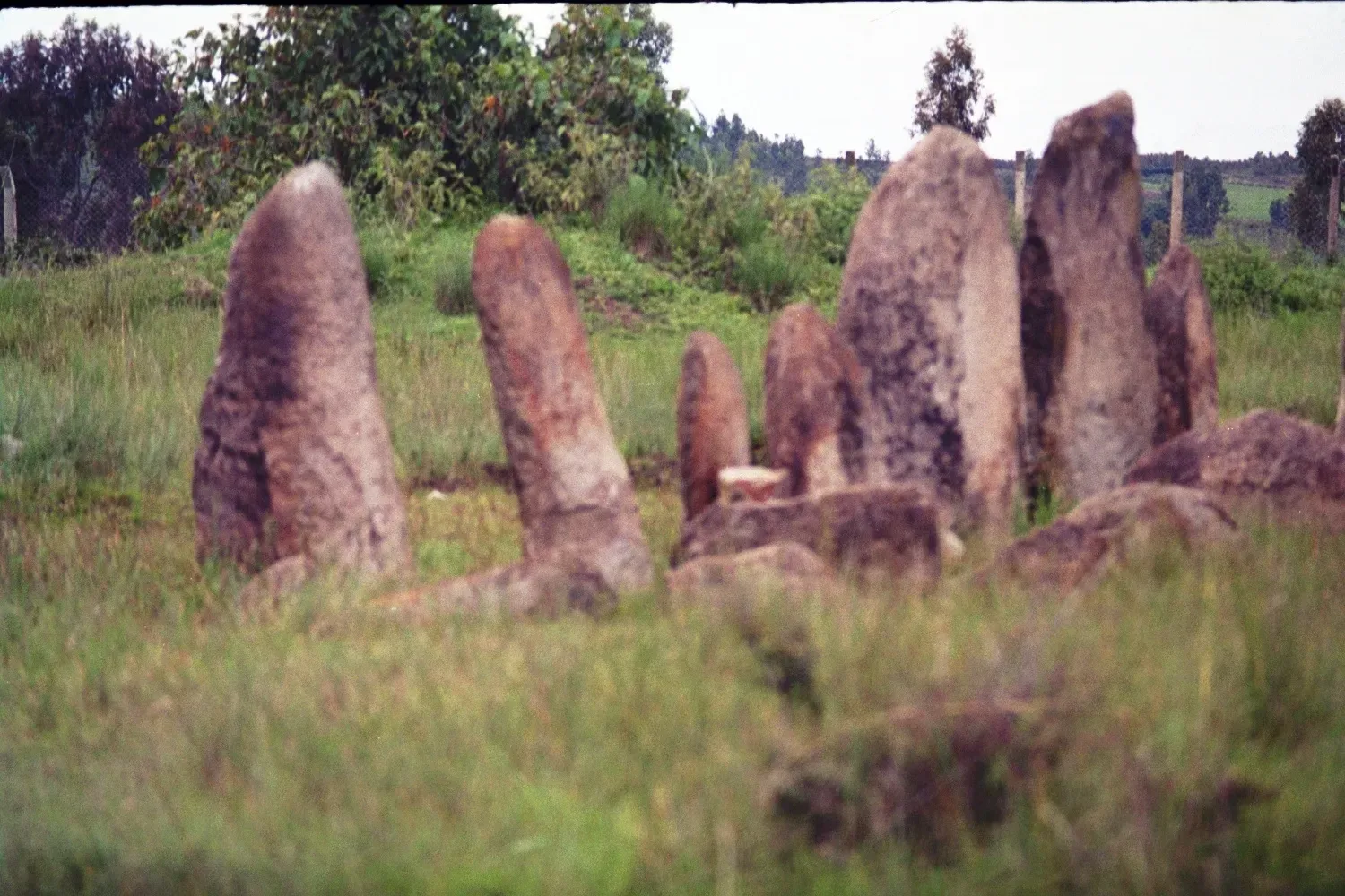
South of Addis Ababa, near the town of Tiya, dozens of carved steles rise from the fields, many decorated with enigmatic swords, geometric patterns, and abstract motifs. These stones are part of a broader, less-publicized tradition of megalithic monuments in Ethiopia and the Horn of Africa, some of which may date back two millennia or more. Excavations at Tiya uncovered human burials associated with the steles, confirming their role as funerary markers, yet the specific cultural groups who raised them remain uncertain. The iconography hints at warrior identities and social status, but with no written records the stories of those individuals have vanished into legend. Unlike the pyramids, which are tied to a well-documented pharaonic state, Tiya’s steles speak for communities that archaeology is only beginning to sketch.
Researchers investigating Tiya and related sites lean heavily on comparative methods, examining stone-working techniques, burial orientations, and stylistic parallels with other regions. The area sits near long-standing trade and migration routes linking the Nile, the Red Sea, and the East African interior, raising the possibility that the megaliths reflect cultural exchanges on an ancient crossroads. Modern dating techniques, including optically stimulated luminescence and refined radiocarbon measurements, are slowly narrowing the chronological windows for different groups of steles. At the same time, community-based archaeology projects are documenting local oral histories and place names that might preserve faint echoes of older traditions. The result is a layered mystery where the stones are clear, solid data points, but the identities behind them remain intriguingly out of reach.
Yonaguni, Japan: Natural Geology or Sunken Megalithic Complex?
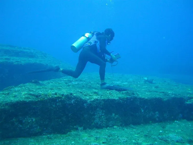
Off the coast of Yonaguni Island in Japan’s Ryukyu archipelago, divers in the 1980s encountered what appeared to be vast, stepped terraces, sharp-edged blocks, and flat platforms rising from the seafloor. Some observers quickly suggested that this was the wreckage of a lost civilization, a kind of Pacific Atlantis sunk by ancient earthquakes and sea-level rise. Geologists, however, have pointed out that the local sandstone naturally fractures into right-angled joints and horizontal layers, which can produce eerily architectural shapes without any human intervention. The debate over Yonaguni has therefore become a high-profile case of how easily the human brain sees patterns and intentional design in what may be purely geological formations. Unlike the pyramids, where quarry marks and tool traces are obvious, evidence for deliberate modification at Yonaguni remains debated and fragmentary.
Scientific dives and surveys have mapped the underwater features in increasing detail, using 3D photogrammetry and sonar to capture their geometry. Some researchers argue that limited carving – such as possible post holes or smoothed edges – suggests at least some human enhancement of a mostly natural structure, perhaps as a ritual site when sea levels were lower during the last glacial period. Others counter that these interpretations rely too much on ambiguous visual cues and that no associated artifacts or clear cultural layers have been recovered. What makes Yonaguni compelling is not just whether it is natural or artificial, but what the controversy reveals about the standards of proof in archaeology. As new imaging technologies spread, similar debates over borderline cases are likely to multiply, forcing scientists and the public to sharpen their sense of what counts as convincing evidence.
Why These Megaliths Matter More Than the Myths
It is tempting to treat megaliths as the playground of speculation, from lost supercivilizations to extraterrestrial masons, but their real significance is actually more radical than those stories. Unlike the pyramids, which are tied to a literate, hierarchical state that left behind texts explaining at least some of its motives, many megaliths sit on the edge of or entirely outside written history. That makes them some of the purest records we have of how humans experimented with large-scale cooperation, sacred landscapes, and engineering long before familiar empires crystallized. By studying quarry marks, tool scratches, burial goods, and microscopic residues, archaeologists can reconstruct social choices that never made it into official chronicles. In that sense, megaliths challenge the idea that “civilization” begins only when writing does.
These sites also force a rethink of what counts as technological sophistication. Polygonal masonry at Sacsayhuamán, long-distance stone transport at Stonehenge, and the early ritual architecture of Göbekli Tepe all show that knowledge can be embodied in practice and tradition rather than formal blueprints or mathematics. Comparing them with more famous monuments like the pyramids highlights how different societies balanced labor, belief, and environment to solve similar problems in distinct ways. At a global scale, clusters of megalithic building appearing independently – from Micronesia to Ireland to Ethiopia – hint at recurring human impulses to anchor stories, ancestors, and power in enduring stone. Understanding those impulses is not just about the past; it speaks to why modern societies still surround themselves with monuments, memorials, and skyscrapers that try to outlast their makers.
From Ancient Tools to Modern Science: How We Decode Megalithic Mysteries
The modern toolkit for studying megaliths would be unrecognizable to the early antiquarians who first measured and sketched them. Today, archaeologists pair traditional excavation with radiocarbon dating, luminescence techniques, and Bayesian statistical models to build tighter chronologies for construction phases and later modifications. Portable X‑ray fluorescence scanners can identify the chemical signatures of stone blocks, tracing them back to specific quarries and revealing transport routes or political control over raw materials. Microscopic wear analysis on stone tools helps distinguish between quarrying, carving, and everyday cutting or scraping, giving a sense of how specialized different tasks were. All of this moves the discussion away from vague wonder and toward testable scenarios of how megaliths were planned, built, and used.
Non-invasive methods have become especially powerful. Ground-penetrating radar, magnetometry, and electrical resistivity surveys can reveal buried ditches, postholes, and walls without turning sacred or fragile landscapes into open pits. High-resolution drone photography and LiDAR scans peel back modern vegetation to expose ancient field systems, processional routes, and minor monuments that contextualize the big, famous stones. Ancient DNA and isotope analysis of human and animal remains add a biological dimension, charting where people and livestock grew up, what they ate, and how closely they were related. In some cases, like Newgrange’s solstice alignment, virtual reconstructions allow researchers to simulate the movement of light and sound within structures at specific dates in the past. The more these techniques converge, the more megaliths transform from mute enigmas into complex data-rich case studies of early societies.
The Future Landscape: New Tech, New Threats, and a Race Against Time
As technologies like machine learning, satellite remote sensing, and ultra-precise dating filters become routine, the study of megaliths is poised for another jump. Algorithms trained to spot geometric anomalies in satellite imagery are already flagging potential stone circles, carnelike formations, and earthworks in regions that have never been systematically surveyed. Improvements in radiocarbon calibration curves and other dating methods promise to shrink chronological uncertainties from centuries to mere decades in some cases, making it easier to link building episodes to climate events or population movements. Multi-spectral imaging can reveal faint carvings and pigment traces on stones that appear blank to the naked eye, resurrecting long-faded symbolic programs. These tools together may finally answer long-standing questions about construction sequences, regional networks, and shifts in ritual emphasis.
At the same time, there is a growing sense that the clock is ticking. Coastal sites like Nan Madol and low-lying stone fields in various parts of the world are threatened by rising seas, stronger storms, and coastal erosion, while inland monuments face pressures from development, looting, and unregulated tourism. Climate-induced vegetation changes can both expose and damage buried features, complicating conservation strategies. Archaeologists now speak of “rescue science,” where documentation and digital preservation sometimes must proceed even when full excavation is impossible. The future of megalithic research will likely be shaped as much by ethical choices about what to disturb, what to digitize, and what to leave to local communities as by any new gadget. In that sense, these ancient stones are forcing twenty-first-century societies to confront how they value deep time heritage in a rapidly changing world.
How Readers Can Engage With Ancient Megaliths Today
For most people, megaliths can feel distant – spectacular in photos but far removed from everyday life – but there are practical ways to connect with and support their ongoing study. Visiting sites in person, when possible, can be powerful, especially if you seek out local guides and interpretive centers that channel tourism revenue into conservation and community projects. Many research teams and heritage organizations now share excavation diaries, 3D models, and virtual tours online, allowing anyone with an internet connection to explore places like Göbekli Tepe or Newgrange in surprising detail. Small actions, such as avoiding touching carvings, staying on marked paths, and respecting access rules, directly reduce wear on fragile stone surfaces. For those far from major monuments, local museums often hold artifacts and host talks that link regional histories to global patterns of monument building.
Supporting science around megaliths also means backing the slow, meticulous work that rarely makes headlines. Donations to reputable archaeological foundations, heritage trusts, or university research projects can help fund fieldwork, conservation, and scholarships for local students who will become the next generation of experts. Paying attention to how infrastructure projects, mining, and tourism developments affect archaeological landscapes – and voicing concerns when necessary – adds social pressure to protect sites before they are damaged. Even something as simple as reading and sharing well-sourced articles helps push back against sensational but misleading narratives that drown out real discoveries. These stones have already survived thousands of years; whether they remain legible for future scientists and visitors depends in part on what we choose to do with them now.

Suhail Ahmed is a passionate digital professional and nature enthusiast with over 8 years of experience in content strategy, SEO, web development, and digital operations. Alongside his freelance journey, Suhail actively contributes to nature and wildlife platforms like Discover Wildlife, where he channels his curiosity for the planet into engaging, educational storytelling.
With a strong background in managing digital ecosystems — from ecommerce stores and WordPress websites to social media and automation — Suhail merges technical precision with creative insight. His content reflects a rare balance: SEO-friendly yet deeply human, data-informed yet emotionally resonant.
Driven by a love for discovery and storytelling, Suhail believes in using digital platforms to amplify causes that matter — especially those protecting Earth’s biodiversity and inspiring sustainable living. Whether he’s managing online projects or crafting wildlife content, his goal remains the same: to inform, inspire, and leave a positive digital footprint.