Every year, scenes of flattened towns, flooded cities, and glowing lava rivers flash across our screens, turning distant geography lessons into raw, human reality. Behind every headline about a record-breaking hurricane or a once-in-a-century flood lies a set of physical rules that are anything but random. Natural disasters are not just freak acts of nature; they are the visible edge of deep, often invisible processes that constantly reshape our planet. Understanding those processes is no longer just an academic exercise reserved for geologists or atmospheric scientists. It is rapidly becoming a form of collective survival knowledge in a world where the line between “natural” and “human-driven” disaster is blurring.
The Hidden Clues: How Earth Warns Us Before Catastrophe
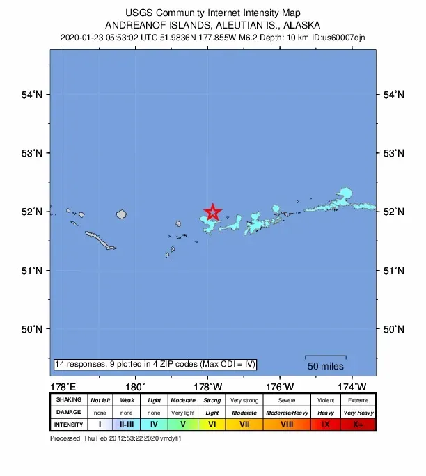
Most natural disasters do not strike completely without warning; rather, they whisper before they roar. Deep under our feet, tectonic plates grind, lock, and suddenly slip along faults, releasing seismic waves that ripple through the crust long before they reach cities at the surface. Networks of seismometers, GPS stations, and strain meters now track these subtle deformations in real time, revealing patterns of stress buildup that once seemed impossible to observe. In some regions, scientists have even identified “slow slip” events – fault motions that unfold over days or weeks instead of seconds – that can precede larger quakes. These events do not stop disasters, but they give us a crucial window into where Earth is storing its energy.
Oceans offer their own clues in the form of changing temperatures, sea-surface heights, and wave patterns that can precede extreme storms and coastal flooding. Satellites scan for warm patches of water that can fuel rapid cyclone intensification, while tide gauges and deep-ocean pressure sensors stand guard for the sudden sea-level rise that marks a tsunami’s passing wavefront. Even the atmosphere leaves fingerprints: abrupt shifts in wind shear, humidity, and pressure are now tracked by dense global observation networks. The science is imperfect, but every new instrument added to this planet-wide listening system turns previously “unpredictable” catastrophes into events we can at least partially anticipate.
Fire from Below: Volcanoes, Earthquakes, and the Restless Crust
Earthquakes and volcanic eruptions are different expressions of the same underlying engine: plate tectonics. The planet’s outer shell is split into rigid plates that move at speeds comparable to how fast fingernails grow, yet over millions of years that slow crawl builds mountains, opens oceans, and loads faults with enormous strain. When a locked fault finally slips, the elastic energy stored in the surrounding rock is released as seismic waves, shaking the ground in patterns that depend on depth, rock type, and fault geometry. Shallow crustal earthquakes tend to be more destructive because their energy has less distance to travel before reaching buildings and infrastructure.
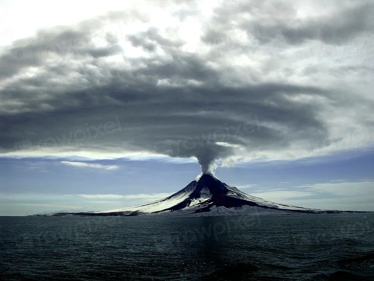
Volcanoes, meanwhile, represent pressure valves where molten rock generated deep in the mantle or at subduction zones finds a pathway to the surface. The violence of an eruption depends on magma chemistry, gas content, and viscosity: runny basaltic magmas tend to create striking but relatively predictable lava flows, while thick, gas-rich magmas can explode with extraordinary force. Some eruptions loft ash and sulfur-rich aerosols high into the stratosphere, where they can cool the planet measurably for a year or more. Monitoring systems watch for subtle signals – swarms of microquakes, rising ground, changes in gas emissions – that can precede major activity. The challenge is that not every signal leads to disaster, forcing scientists to balance false alarms against the risk of staying silent.
When Air and Ocean Collide: The Physics of Storms and Floods
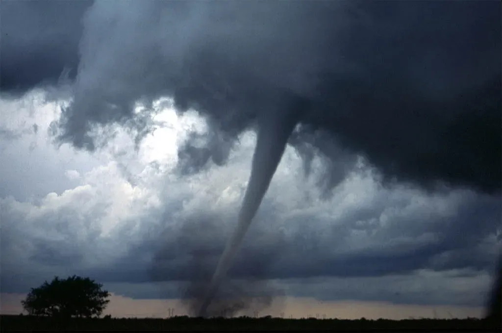
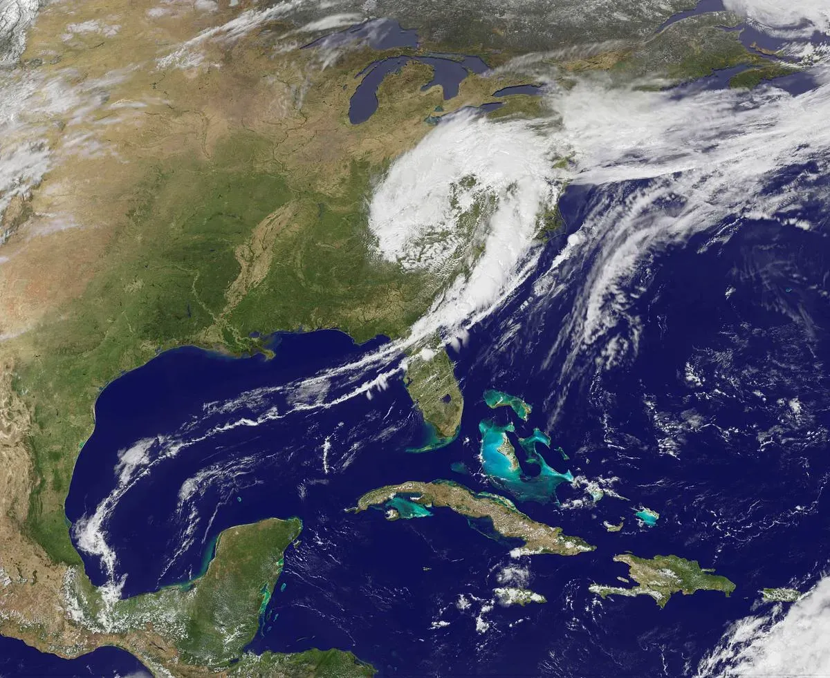
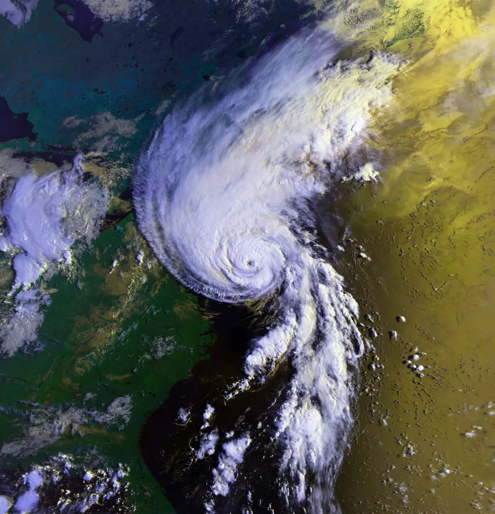
Hurricanes, typhoons, and other tropical cyclones are among Earth’s most photogenic and terrifying disasters, yet their basic physics is straightforward. Warm ocean water evaporates, rises, and condenses into towering clouds, releasing heat that fuels more rising air in a self-reinforcing loop. When conditions are just right – sufficiently warm water, low wind shear, and an initial disturbance – the system organizes into a rotating engine that can span hundreds of miles. The eye, calm and eerily clear, is surrounded by a wall of intense thunderstorms where wind speeds and rainfall reach their peak. Storm surge, driven by persistent winds and low pressure that physically raises the sea surface, often becomes the deadliest aspect once the storm hits land.
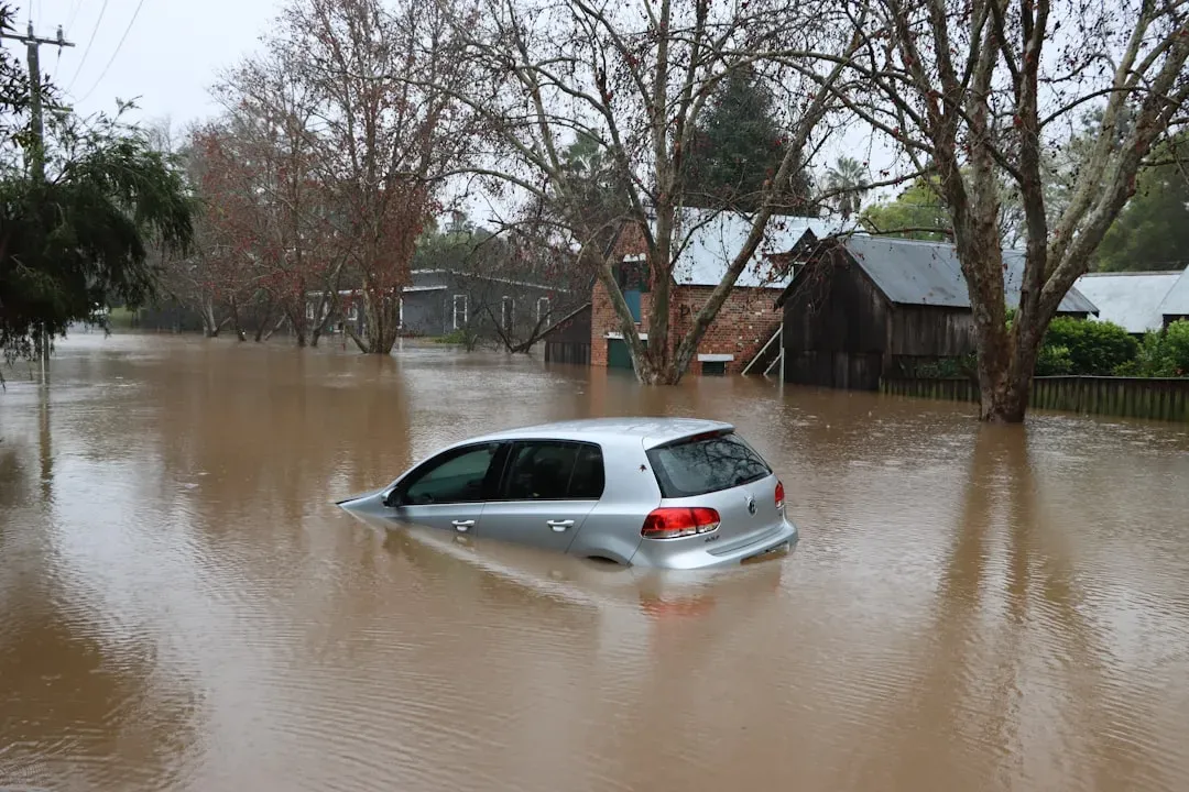
Floods are not limited to coastlines. Rivers swell when heavy rainfall outpaces the ability of soil, vegetation, and channels to absorb or carry away the water. Urban areas are particularly vulnerable because concrete and asphalt act like waterproof armor, shunting rain into drainage systems that can be overwhelmed in hours. Scientists now use high-resolution rainfall radar, computer models, and historical records to predict where runoff will concentrate and which neighborhoods are most at risk. At the same time, the warming atmosphere can hold more moisture, meaning storms can now drop heavier bursts of rain than in previous decades, even in regions that are not seeing more storms overall. This combination of physics and infrastructure choices often determines whether a major storm becomes a headline-making catastrophe.
Shifting Baselines: How Climate Change Amplifies Disasters
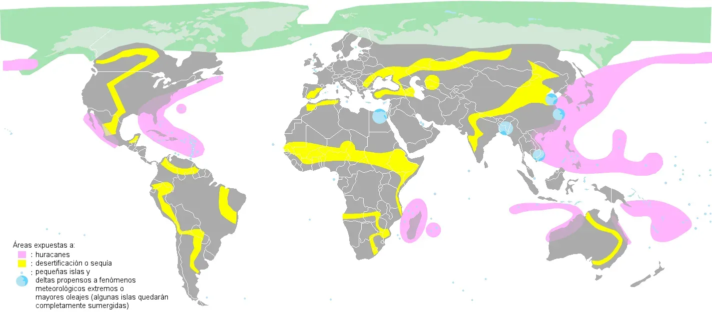
One of the most unsettling insights of modern earth science is that climate change is turning many natural hazards into more dangerous versions of themselves. Warmer seas provide extra fuel for intense hurricanes and cyclones, increasing the odds that a storm will undergo rapid intensification near coastlines. A hotter atmosphere acts like a bigger sponge for water vapor, raising the potential for extreme rainfall events that can overwhelm drainage systems and riverbanks. At the same time, long-term warming and changing precipitation patterns are drying out forests and grasslands in many regions, priming them for massive wildfires that can create their own storm-like winds and even lightning.
Sea-level rise adds another, slower but relentless layer of risk. Even modest increases in average sea level mean that storm surges and so-called nuisance tides start from a higher baseline, allowing water to reach further inland than historical records would suggest. This shifts the definition of a “one-in-one-hundred-year” flood, making what once seemed rare occur noticeably more often within a human lifetime. Glaciers and ice sheets, especially in Greenland and Antarctica, continue to lose mass, locking in additional sea-level rise over coming centuries. Together, these changes blur the line between natural variability and human-driven risk, forcing scientists and policymakers to rethink how they map danger zones and plan for the future.
Why It Matters: From Distant Headlines to Local Decisions
The science behind disasters might sound abstract until you realize how directly it shapes the safety of homes, schools, and hospitals. Building codes in quake-prone regions are based on detailed analyses of fault behavior, ground motion, and past shaking intensity. In places that take this seriously, many structures can withstand severe shaking that would once have been unsurvivable. Floodplain maps are drawn from decades of river-flow data and increasingly from sophisticated climate and land-use models; they guide decisions about where to build, where to buy insurance, and where to restore wetlands that can absorb excess water. Early-warning systems, even when they buy only seconds or minutes, allow trains to slow, factories to shut off gas lines, and people to duck under sturdy furniture.
In my own life, the shift from seeing disasters as distant spectacles to local realities came when a supposedly routine rainstorm turned my neighborhood street into a temporary river. The flooding was mild compared with what many communities endure, but the pattern was clear: storm drains built for a different era were being pushed to their limits. That experience made abstract terms like “intense precipitation events” feel concrete and immediate. Around the world, countless people are going through similar realizations, often with far higher stakes. The better we understand the forces at work, the less we are caught off guard when they arrive at our doorstep.
From Ancient Tools to Modern Science: Reading the Planet’s Disaster Archive
Long before satellites and supercomputers, people turned to the landscape itself to understand disasters. Coastal communities remembered the reach of past tsunamis through oral histories and stone markers, sometimes warning future generations not to build below certain lines. River farmers learned, often painfully, where floodwaters tended to spread and adapted their planting cycles to match. Early scientists measured water levels on simple staffs and tracked the timing of seasonal floods, gradually building the first flood records that modern hydrologists still reference. Seismology began with instruments barely more advanced than weighted pens tracing wavy lines on smoking-paper drums.
Today, that historical and geological archive is being read with far greater precision. Tree rings reveal years of drought and sudden bursts of growth after floods, while lake sediments preserve thin layers of sand and ash from ancient tsunamis and eruptions. Ice cores capture traces of past volcanic aerosols that dimmed sunlight across the globe. Combined with written records, these natural archives allow scientists to reconstruct centuries or even millennia of disaster history. That, in turn, helps them understand how rare the most extreme events really are and whether what we call “unprecedented” today truly lies outside the range of past variability.
Global Perspectives: When Local Hazards Become Worldwide Shocks
One of the defining features of disasters in the twenty-first century is how quickly local events ripple through global systems. A single major earthquake can cut off key ports or factories, disrupting supply chains for electronics, cars, and even medical equipment half a world away. A flood in a major grain-producing region can tighten food supplies and raise prices for millions of people who never see a drop of that water. Large volcanic eruptions that inject ash and sulfur high into the atmosphere can dim sunlight and alter weather patterns on multiple continents, affecting harvests and energy demand. Wildfires release huge plumes of smoke that can travel across oceans, degrading air quality and visibility far from the flames.
This interconnectedness cuts both ways, offering tools as well as threats. Satellite networks allow countries to share near-real-time imagery of storms, fires, and floods, helping disaster agencies coordinate responses. International seismographic and tsunami-warning systems mean that data from sensors in one nation can save lives in another within minutes. Yet global inequality shapes who can act on this information: wealthier countries are often better equipped with reinforced infrastructure, insurance systems, and emergency plans. Understanding disasters as global phenomena highlights the need for shared data, shared responsibility, and support for communities on the front lines whose losses reverberate far beyond their borders.
The Future Landscape: New Technologies and New Risks
The science of disasters is entering a phase where predictive power is expanding, but so are the stakes. Machine-learning models now sift through torrents of sensor data to spot subtle patterns that might precede earthquakes, landslides, or infrastructure failures. High-resolution climate and weather simulations can map how a single storm may evolve over the next few days, block by block, guiding targeted evacuations instead of blanket orders. Drones and small satellites provide frequent, detailed imagery of vulnerable coastlines, wildfire zones, and glacial valleys, revealing changes that would have gone unnoticed a decade ago. Urban digital twins – virtual replicas of cities – let planners test how future floods or quakes might play out before they ever happen.
At the same time, human choices are creating new layers of vulnerability. Rapid urbanization in floodplains and coastal zones, expansion into fire-prone forests, and aging infrastructure in many countries mean that even moderate events can have outsized consequences. Emerging technologies like large-scale seawalls, floating neighborhoods, or geoengineering proposals introduce their own uncertainties and ethical questions. The coming decades will likely see a mix of cutting-edge warning systems and very old problems, such as poverty and weak governance, determining who gets hurt and who recovers quickly. The science will keep improving, but it will not erase the need for tough decisions about where and how we live.
What You Can Do: Turning Knowledge into Action
The scale of natural disasters can make individual action feel tiny, but the science tells a different story. Risk is a combination of hazard, exposure, and vulnerability, and that last part – how fragile or resilient we are – is something people can and do change. Learning whether your home or workplace sits in a floodplain, fire zone, or seismic hotspot is a first, concrete step. Simple measures like securing heavy furniture, preparing a go-bag, or knowing evacuation routes can dramatically improve survival odds when seconds count. Supporting good building codes and land-use planning, even when they are inconvenient, is another way everyday choices reshape long-term risk.
On a broader level, backing policies and projects that cut greenhouse-gas emissions and restore natural buffers like wetlands and forests helps address the amplifiers that turn hazards into catastrophes. Paying attention to local science reporting, joining community preparedness drills, or volunteering with relief and resilience organizations weaves individuals into a wider safety net. Even conversations with friends and family – comparing plans, sharing reliable information, challenging myths – can shift a community’s baseline of readiness. The forces that drive disasters are vast, but they are not beyond our understanding, and understanding is the first step toward changing the outcome the next time Earth decides to remind us who is in charge.

Suhail Ahmed is a passionate digital professional and nature enthusiast with over 8 years of experience in content strategy, SEO, web development, and digital operations. Alongside his freelance journey, Suhail actively contributes to nature and wildlife platforms like Discover Wildlife, where he channels his curiosity for the planet into engaging, educational storytelling.
With a strong background in managing digital ecosystems — from ecommerce stores and WordPress websites to social media and automation — Suhail merges technical precision with creative insight. His content reflects a rare balance: SEO-friendly yet deeply human, data-informed yet emotionally resonant.
Driven by a love for discovery and storytelling, Suhail believes in using digital platforms to amplify causes that matter — especially those protecting Earth’s biodiversity and inspiring sustainable living. Whether he’s managing online projects or crafting wildlife content, his goal remains the same: to inform, inspire, and leave a positive digital footprint.