You grow up thinking people built monuments to be stared at from ground level: towering pyramids, soaring cathedrals, gigantic statues. Then you see photos from the air of giant animals, perfect shapes, and strange figures carved into the earth long before anyone even dreamed of airplanes, and your sense of perspective shifts completely. These ancient land artists were designing for an audience in the sky, and you are only just catching up. What makes these places so gripping is that, from the ground, many of them feel underwhelming or even invisible. You can stand on top of them and have no idea you are literally walking across a drawing the size of a city block. Only when you rise above them – by plane, drone, or satellite – does the full picture snap into focus, as if someone has switched on a secret layer of the world you were never meant to see from eye level.
Nazca Lines, Peru: A Desert Meant to Be Read from the Sky
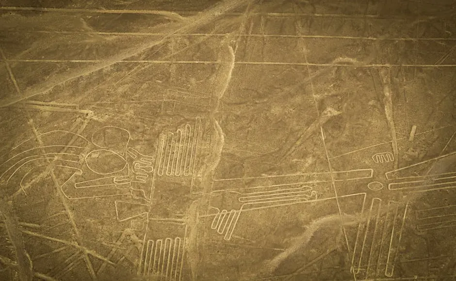
If there is one place that makes you question how ancient people thought about space and scale, it is the Nazca Lines in southern Peru. Here, across a high, dry desert plateau, you find hundreds of straight lines, spirals, trapezoids, and enormous figures of animals and plants etched into the ground, some stretching hundreds of meters long. From where you stand in the sand, they feel like random paths or faint scratches, but once you get airborne, they transform into razor-clean geometric designs and stylized creatures marching across the desert floor. ([en.wikipedia.org](https://en.wikipedia.org/wiki/Nazca_lines?utm_source=openai)) Archaeologists date most of these geoglyphs to between about two thousand and roughly fifteen hundred years ago, long before balloons, gliders, or aircraft existed. You can view tiny sections from surrounding hills, but the overall designs really make sense only when you look down from the air, which is why small planes now fly tourists in slow loops so you can trace the outlines of hummingbirds, monkeys, and condors with your eyes. ([jpl.nasa.gov](https://www.jpl.nasa.gov/news/nasa-radar-brings-a-new-view-of-world-heritage-site/?utm_source=openai)) You still do not have a single agreed explanation: were they ritual paths, astronomical markers, offerings to mountain and water deities, or something else entirely? Whatever the answer, you are looking at a culture that thought big – so big their artwork only fully exists when you leave the ground.
Blythe Intaglios, California: Giant Desert Figures You Walk Past Without Seeing
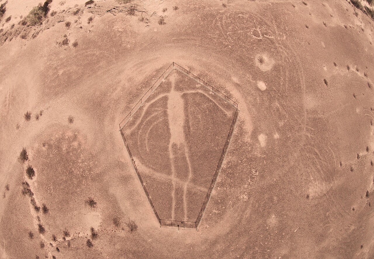
Drive through the Colorado Desert near Blythe, California, and you can be right next to some of North America’s most astonishing ancient works of art and never know it. The Blythe Intaglios are huge figures – human shapes, animals, and a spiral – scraped into the desert surface by removing the dark, oxidized stones to reveal lighter earth beneath. ([en.wikipedia.org](https://en.wikipedia.org/wiki/Blythe_Intaglios?utm_source=openai)) Some figures stretch longer than a modern jetliner, yet from the ground your view is so flat and close that they dissolve into a jumble of rocks and low ridges. To really see them, you have to get above them; that is why most of the famous images are taken from aircraft or drones, where the startling human forms suddenly snap into view, arms outstretched across the desert. Radiocarbon and stylistic clues suggest these geoglyphs are many centuries old, created long before powered flight, and probably tied to the ceremonial life of Indigenous peoples along the lower Colorado River. ([en.wikipedia.org](https://en.wikipedia.org/wiki/Blythe_Intaglios?utm_source=openai)) You can imagine people gathering, walking along the lines, telling stories about the giant “sky people” on the ground, all without ever seeing the designs the way a pilot does. When you finally see them from the air yourself, you get a weird double feeling: on one hand, the figures look almost modern, like gigantic stick people someone drew for fun; on the other hand, you are staring at sacred marks left by communities who saw the same ground from a completely different mental altitude.
Uffington White Horse, England: A Chalk Image That Makes Sense Only from Afar
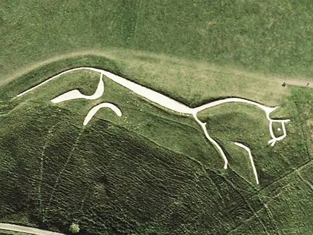
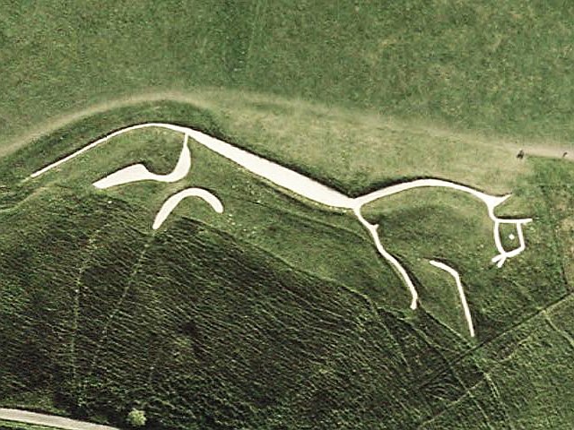
When you first visit the Uffington White Horse in Oxfordshire, you might be surprised by how hard it is to see. You stand on the steep hillside, staring at strips of brilliant white chalk cut into the turf, and it looks like a collection of disjointed curves more than a clear horse. Then you see an aerial photo or catch a distant view from across the valley, and suddenly the abstract pieces become a sleek, almost modern-looking running horse spread out over more than a hundred meters of hillside. ([hows.org.uk](https://www.hows.org.uk/personal/hillfigs/uff/uffing.htm?utm_source=openai)) Dating techniques place its creation roughly between about eight hundred and six hundred years before the common era, making it around three thousand years old – older than many classical monuments you probably know by name. ([storymaps.arcgis.com](https://storymaps.arcgis.com/stories/c33499e87dd249c481cc2d434a0d3ec0?utm_source=openai)) It is one of the oldest known hill figures in Britain, yet its design feels strikingly minimalist, as if it were made for a logo, not a Bronze Age landscape. From the valley below, or even better from the air, the entire horse is clean, bold, and unmistakable. You cannot prove the builders ever expected a true bird’s-eye view, but they clearly understood that by stretching a figure across a steep slope, you create an image that only resolves at a distance – an ancient form of large-format design that your age is finally equipped to appreciate properly.
Cerne Abbas Giant, England: A Monument Hidden in Plain Sight on a Hillside
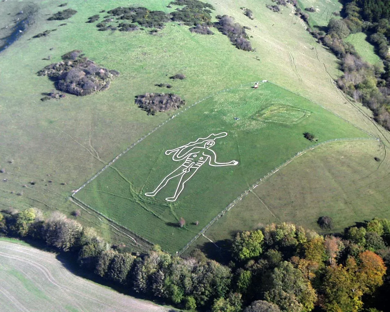
If you know the Cerne Abbas Giant in Dorset at all, it is probably for its unapologetically explicit anatomy and its reputation for fertility folklore. From the bottom of the hill, you can see a looming human figure outlined in white chalk, holding a club and towering above the village. But what you only grasp clearly from the air is how formally precise its proportions and outline actually are, and how it dominates the entire slope like a gigantic logo stamped onto the landscape. A hillside path gives you only a distorted slice; a drone photo turns it into a crisp, almost cartoon-like figure that makes perfect visual sense. ([countrylife.co.uk](https://www.countrylife.co.uk/countryside/rural-life/the-chalky-figures-festooning-our-landscape-are-still-something-of-a-mystery?utm_source=openai)) Recent dating work suggests the giant likely dates back many centuries, probably to the late Saxon or medieval period, which still puts it almost a thousand years before any airplane flew overhead. During the Second World War, it was reportedly covered to stop enemy pilots using it as a navigation mark, which is a grimly practical acknowledgment of how visible it is from the sky. ([countrylife.co.uk](https://www.countrylife.co.uk/countryside/rural-life/the-chalky-figures-festooning-our-landscape-are-still-something-of-a-mystery?utm_source=openai)) When you look at modern aerial shots, it becomes obvious why: the giant is so cleanly cut and so perfectly arranged on its slope that it reads instantly from above, almost like a giant road sign. You end up asking yourself whether you are looking at a ritual figure, a political joke from long ago, or an early example of humans instinctively thinking in aerial graphics long before they could actually fly.
Long Man of Wilmington, England: A Two-Staff Figure Built for a High Vantage Point
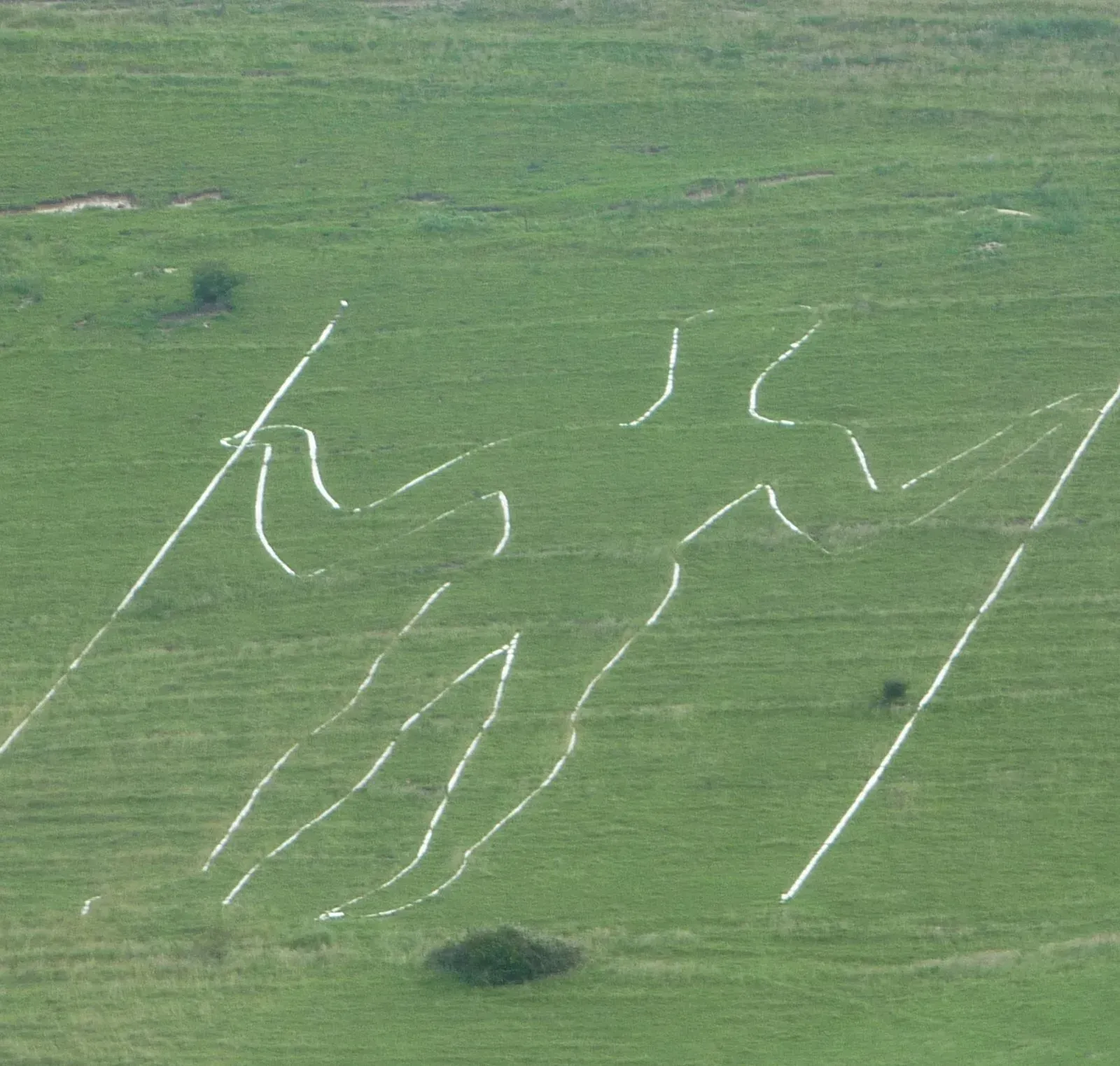
On the steep slopes of Windover Hill in East Sussex, the Long Man of Wilmington stands taller than many modern buildings, outlined in pale chalk that you might just glimpse from passing roads. Up close, the figure is strange and hard to read, with two long “staffs” and a thin, almost ghostly body disappearing into the incline. Step back a few kilometers – or look from the sky – and suddenly that same figure tightens into a dramatic vertical image, clean-lined and unmistakable against the green hillside. ([countrylife.co.uk](https://www.countrylife.co.uk/countryside/rural-life/the-chalky-figures-festooning-our-landscape-are-still-something-of-a-mystery?utm_source=openai)) The Long Man’s exact age is debated, but many specialists think you are looking at a monument that is at least several centuries old and probably closer to a millennium. Either way, it pre-dates airplanes by a vast margin. During wartime, his outline, like other large chalk figures, was deliberately obscured so enemy aircrews could not use him as a landmark, a very literal sign of how navigational these hillside images become once you see them from above. ([countrylife.co.uk](https://www.countrylife.co.uk/countryside/rural-life/the-chalky-figures-festooning-our-landscape-are-still-something-of-a-mystery?utm_source=openai)) When you look at high-angle photographs today, he almost resembles the minimalist logo for a hiking brand – simple, bold, and readable from a long way off – which makes you realize that our modern taste for graphic clarity is not as new as you think.
Paracas Candelabra, Peru: A Gigantic “Trident” Facing the Sea
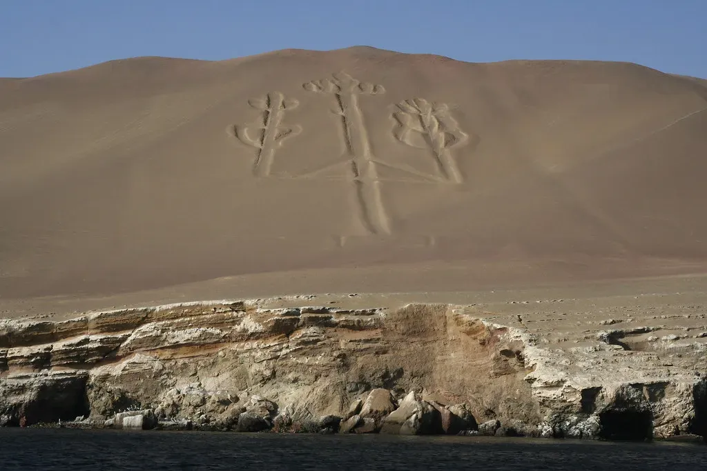
On the Paracas Peninsula, north of the Nazca region, there is a single, stark geoglyph that looks like a giant candelabra or trident carved into a sloping dune above the Pacific. From a boat, you can see it etched into the sandy hillside, but the clearest view comes from the air, where its long central shaft and branching arms stretch tens of meters across, pointing inland like an enormous directional symbol. The contrast between the pale carved channels and the darker surrounding sand makes it read like a monumental sign designed for someone arriving from the ocean or the sky. ([arxiv.org](https://arxiv.org/abs/1109.3319?utm_source=openai)) Archaeological evidence ties the geoglyph to the Paracas culture, which flourished many centuries before the Nazca Lines, meaning you are looking at a motif at least about two millennia old. No one can tell you for sure if it was meant as a navigational beacon for seafarers, a ritual symbol linked to local deities, or part of a wider pattern of geoglyph traditions along the Peruvian coast. What you can say confidently is that the design makes the most sense when you lift yourself above it; like a runway symbol or a giant arrow, the Candelabra only fully reveals its stark elegance when you are high enough to see the whole shape at once.
Chincha Valley Geoglyphs, Peru: Lines for Trade Routes and Ritual Paths
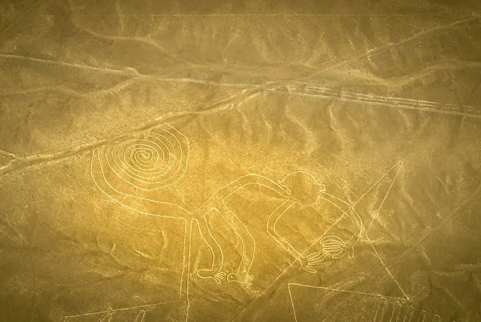
South of Lima, in the Chincha Valley, you find a quieter cousin to the Nazca Lines: a network of long, straight geoglyph lines and stone-built features running over hills and pampa. From the ground, many of these look like simple paths or low walls, easily swallowed by the uneven terrain. Once you look at satellite imagery or aerial surveys, you start to see the pattern: radiating lines converging on ancient settlements, stone cairns defining alignments, and elongated shapes that clearly were meant to be understood from above or from distant vantage points. ([arxiv.org](https://arxiv.org/abs/1109.3319?utm_source=openai)) Research in recent years suggests these features were connected to pre-Inca societies and later the Inca themselves, linking ceremonial sites, cemeteries, and trade routes across the valley. You are probably dealing with a tradition where walking along the lines, seeing processions move in straight, purposeful paths, mattered just as much as any imagined view from the sky. But when you study them through aerial images, the full logic of the system jumps out: these were people organizing the landscape at a grand scale, thinking in corridors and alignments that only really show their structure when you step back mentally to the altitude of a drone or small plane. In a way, you are only now catching up to the design language they carved directly into the terrain.
Wari and Other Andean Geoglyphs: Hidden Patterns on Mountain Slopes and Plains
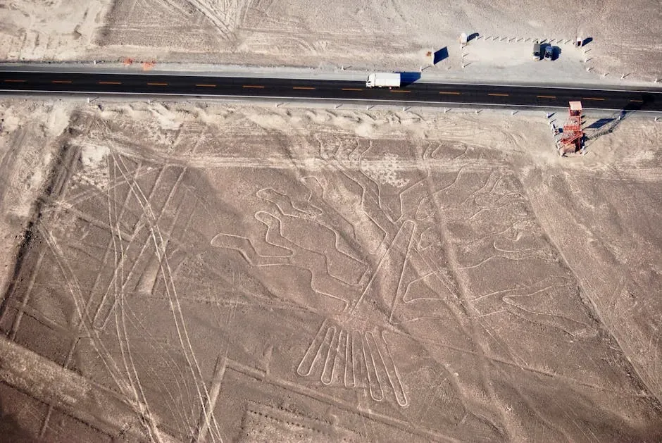
Across the wider Andean region, you keep finding a pattern that feels almost eerie once you notice it: large shapes and lines on hillsides and plains, made by clearing stones or building low walls, dating back to cultures like the Wari and their neighbors centuries before the Inca empire. At eye level, these features can look like stray walls or old field boundaries, nothing that would stop you on a casual hike. Flip to aerial photos, and some resolve into animals, abstract forms, or geometric layouts that clearly were planned at a scale no one at ground level can easily read. ([arxiv.org](https://arxiv.org/abs/1210.1170?utm_source=openai)) You do not always have the crisp, unmistakable zoom-lens shapes you see at Nazca, and in many cases the evidence is subtle or partially eroded. That is exactly why you need to be careful and honest about what you claim: sometimes you are sure you are looking at an intentional design, other times it is more of a strong possibility than a proven fact. What is solid, though, is the broader pattern: Andean societies repeatedly modified the earth’s surface on a massive scale, creating arrangements that only show their full coherence when you take a high viewpoint. When you scroll over them in satellite view today, you are, in a sense, becoming the “viewer in the sky” these builders never met but somehow anticipated in the way they laid out their world.
Conclusion: Earthworks That Make You Think Like a Bird
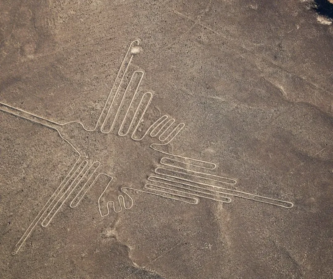
Once you have seen these places from the air – even if it is just through other people’s photos – you cannot unsee the idea that ancient designers were playing with scale in ways that feel strikingly modern. From chalk horses racing across English hills to desert lines stretching over Peruvian pampas, you are dealing with monuments that only fully come alive when your vantage point leaves the ground. They were built in ages when flight was myth, not technology, yet they seem tailor-made for the eye of a bird, a god, or, much later, a pilot. When you next walk through an open landscape, it is hard not to wonder what shapes might lie under your feet, invisible from where you stand but obvious from a hundred meters up. Are you absolutely sure your world is only arranged for ground-level eyes, or is there a whole layer of design that only really appears when you think – and look – like something that can fly?