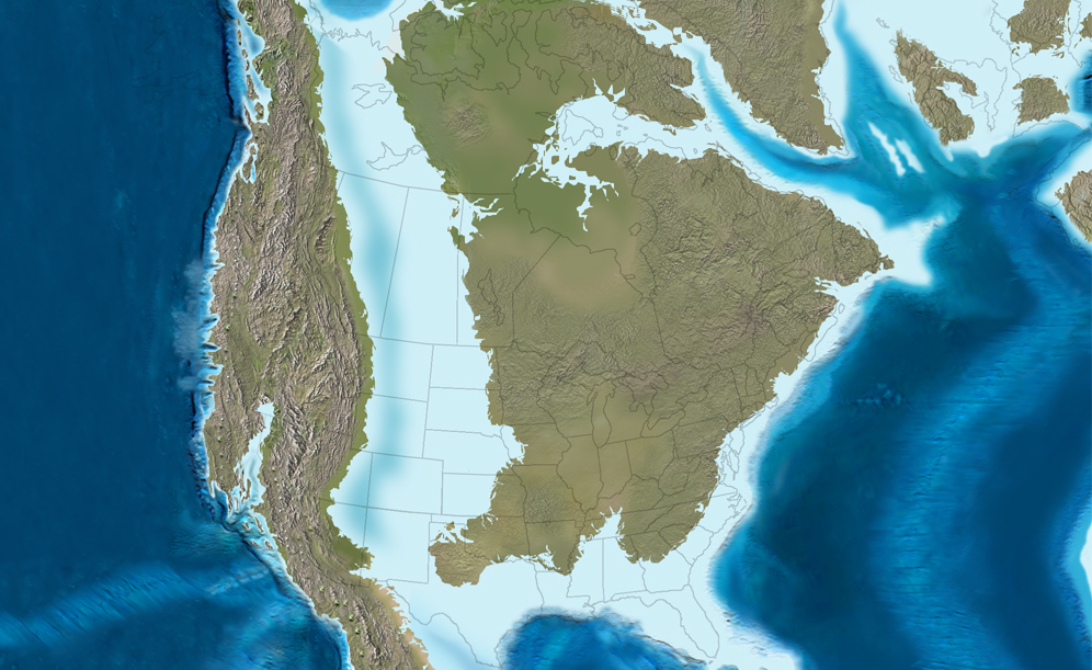
If you could rewind Earth’s clock by tens of millions of years and fly over what is now the heart of North America, you would not see endless prairies, highways, or cities. You’d see waves. Instead of grain fields stretching across the Midwest, there would be a shallow, glittering sea swarming with marine reptiles, strange birds, and clouds of tiny shell‑building plankton drifting in sunlit waters. The continent you know would be sliced in two by a vast body of water called the Western Interior Seaway.
This is not some fringe idea from speculative fiction; it is one of the most dramatic, well‑supported chapters in Earth’s history. That ancient inland sea reshaped climate, carved out rocks we now hike through, and left behind fossils that keep rewriting what we thought we knew about dinosaurs, oceans, and even mass extinctions. Once you realize that places like Kansas, Nebraska, and Alberta sat under warm, tropical seas, it becomes hard to look at any roadcut or canyon the same way again.
The Sea That Split a Continent in Two
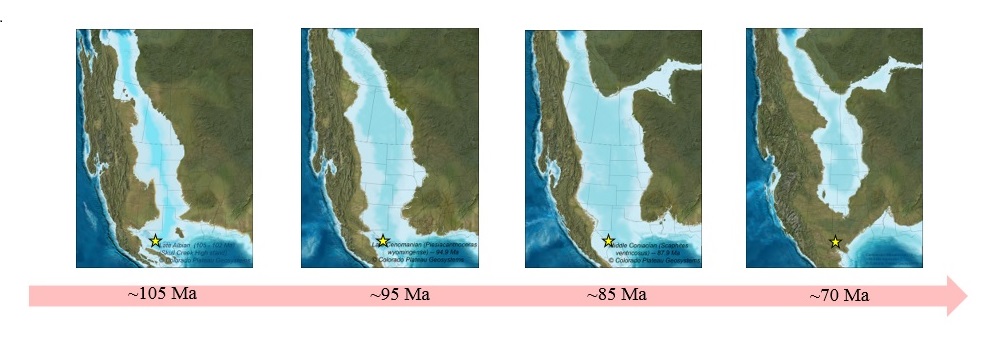
The Western Interior Seaway was a broad, shallow ocean that stretched from what is now the Arctic Ocean down to the Gulf of Mexico during much of the Late Cretaceous period, roughly between about one hundred and sixty‑six million years ago. Imagine a watery corridor running right through the middle of North America, turning it into two long island‑like landmasses: Laramidia to the west and Appalachia to the east. At its maximum extent, this seaway was thousands of kilometers long and hundreds of kilometers wide, comparable in scale to some modern marginal seas.
Geologically speaking, this seaway was not especially deep by open‑ocean standards, often only a few hundred meters or less, but that shallow depth made it incredibly dynamic. Tides, storms, and shifting coastlines constantly rearranged bays, deltas, and lagoons along its margins. Where we now see badlands and wheat fields, there were once muddy seafloors, coral‑like reef systems, and sand bars that migrated with each storm season. The fact that this sea could appear, expand, shrink, and largely disappear within a window of tens of millions of years shows just how alive and flexible continents really are.
Why a Giant Ocean Formed in the Middle of a Continent
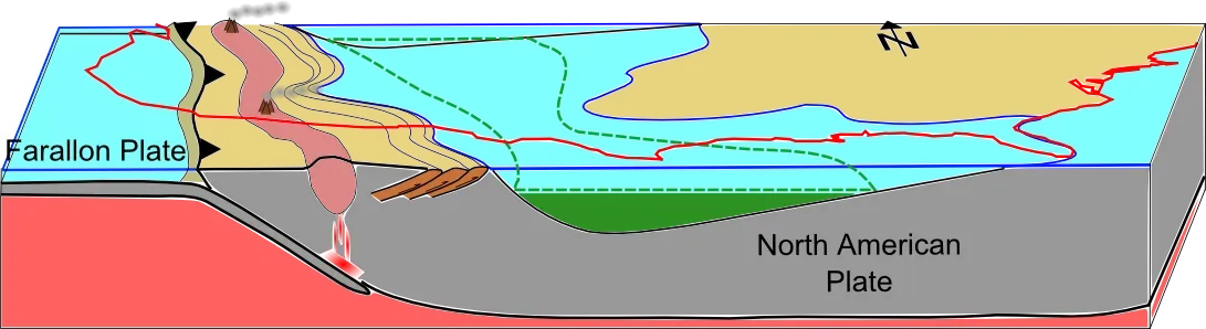
At first glance, it sounds absurd that an ocean could open up right in the middle of a continent that seems solid and immovable today. The key lies in plate tectonics and the way Earth’s crust flexes under massive forces. During the Cretaceous, an oceanic plate in the Pacific region was sliding, or subducting, beneath the western edge of North America at a relatively shallow angle. That low‑angle subduction pushed far inland, warping the central portion of the continent downward like a mattress sagging under a heavy sleeper.
As the central crust bowed down, global sea levels were higher than they are today, in part because there was little or no continental ice and because mid‑ocean ridges were more active, displacing water onto the continents. The result was a perfect recipe: a lowered continental interior plus raised global sea level allowed marine waters to flood in from both the north and the south. Over time, these waters linked up, turning river valleys and lowlands into a continuous seaway. It is a powerful reminder that continents are not rigid platforms but elastic surfaces constantly being bent, stretched, and reshaped by the invisible machinery of plate tectonics beneath our feet.
Life in the Western Interior Seaway: Monsters, Fish, and Microscopic Builders
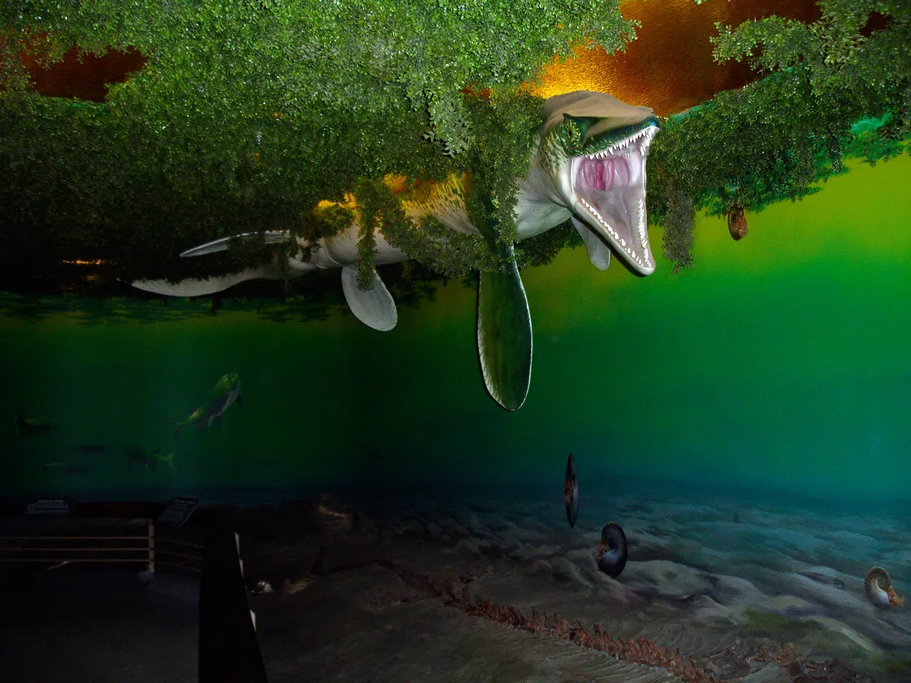
The Western Interior Seaway was far from an empty bathtub of water; it was one of the most biologically rich environments of its time. In its depths cruised large marine reptiles like mosasaurs and plesiosaurs, some longer than a bus, powerful predators that hunted fish, squid‑like cephalopods, and even each other. Large fish, including shark lineages, patrolled the open water, while smaller schooling fish darted through shallower coastal zones. Flying reptiles and early birds skimmed the surface, diving for prey just as seabirds do today.
Equally important, though far less dramatic to the naked eye, were the tiny organisms that built the seaway’s foundation. Microscopic plankton, including algae and small shell‑forming creatures, floated in sunlight‑soaked surface waters, photosynthesizing and turning solar energy into biomass. When they died, their shells and bodies rained down as a constant drizzle of carbon‑rich particles, slowly building up thick layers of mud and chalk on the seafloor. In a sense, the grand marine reptiles were just the flashy mascots of a system quietly powered by these tiny, drifting architects that literally helped write the seaway’s history into the rocks.
Dinosaurs on Opposite Shores: How the Sea Shaped Evolution
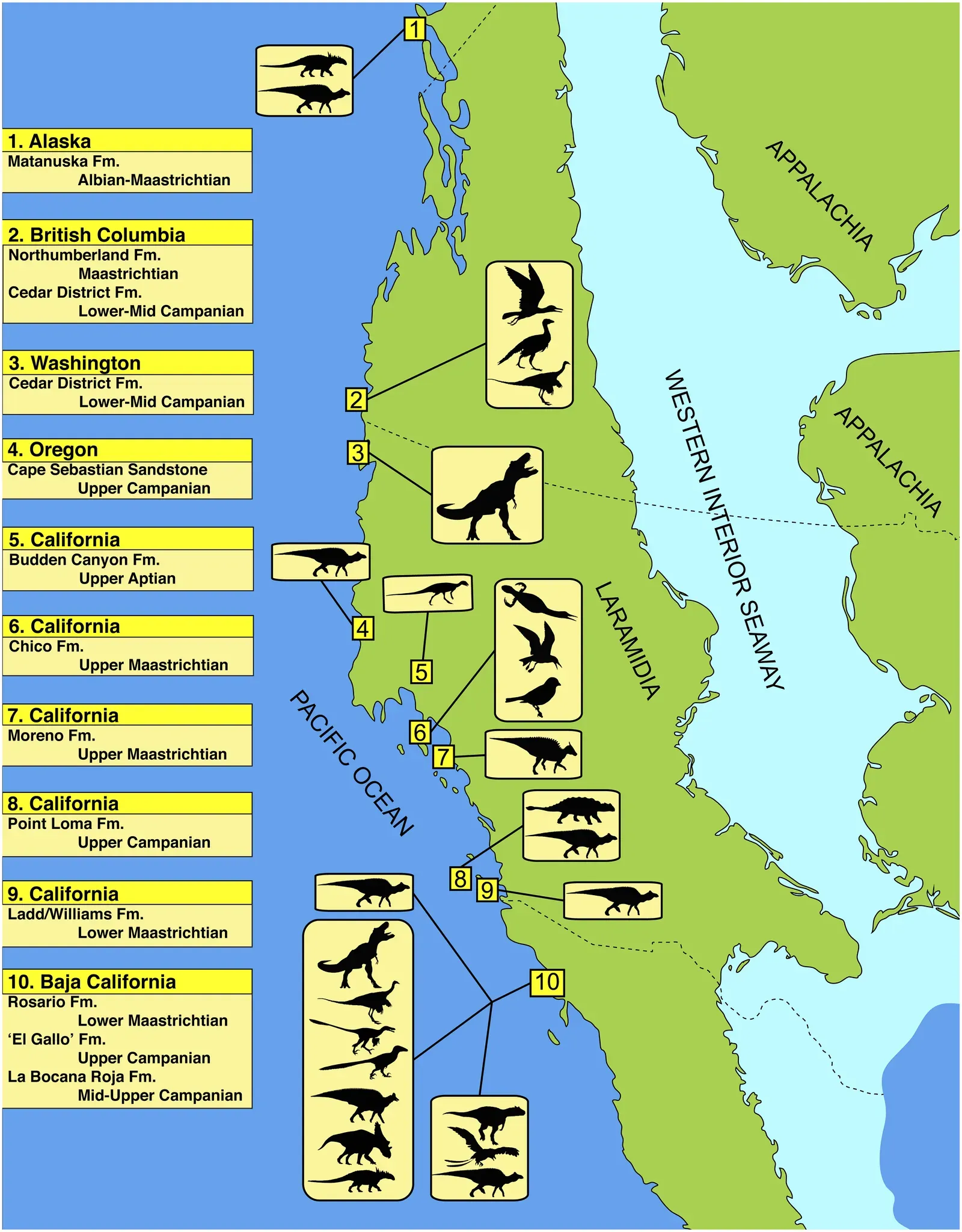
While marine life thrived in the seaway, the land on either side followed its own evolutionary path. With a broad body of water slicing the continent, dinosaur populations on western Laramidia and eastern Appalachia were essentially isolated from one another for millions of years. That separation worked a bit like an enormous natural experiment in evolution: lineages that once shared common ancestors were forced to adapt to different climates, landscapes, and food sources on each side, with little or no gene flow between them. Over time, that kinds of isolation can lead to distinct species and unique ecosystems.
This helps explain why the fossil record from western North America is packed with famous dinosaurs like Tyrannosaurus and Triceratops, while the still‑understudied eastern record shows a different flavor of dinosaur life. The seaway functioned like a giant moat, limiting who could cross and when, and turning each side into its own evolutionary playground. When paleontologists compare fossils from each region, they see not just different animals but different ecological stories shaped by the presence of this inland sea. In a way, the Western Interior Seaway edited the cast list of Cretaceous dinosaurs in North America simply by existing.
From Seafloor to Farmland: The Rocks and Resources It Left Behind
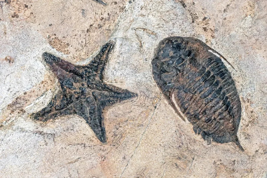
The legacy of the Western Interior Seaway is literally under our feet, especially across the Great Plains and parts of the western interior provinces and states. The slow rain of shells, mud, and organic debris that once fell through its waters hardened into thick layers of shale, limestone, chalk, and sandstone. Today, those rocks form everything from the soft, white cliffs exposed in roadcuts to the colorful badlands eroded into eerie shapes. Many classic fossil‑rich formations in places like Kansas, South Dakota, and Alberta are direct products of sediments laid down in or near the seaway.
Those sediments did more than store fossils; they also trapped and preserved organic material that would eventually be transformed into hydrocarbons under pressure and heat. Some of the oil and gas resources that modern society depends on are tied to the organic‑rich muds deposited in these ancient marine settings. Calcium‑rich chalk and limestone derived from the skeletons of uncounted microscopic organisms now serve as building stone, soil conditioners, and industrial materials. It is a strange irony that the same sea that once swarmed with prehistoric life now underpins agriculture, construction, and energy in the very regions it used to drown.
The Sea That Vanished: Climate, Retreat, and Mass Extinction
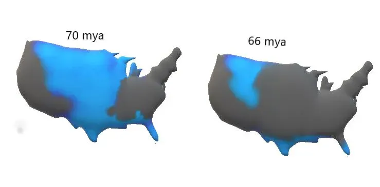
Like all things in Earth’s history, the Western Interior Seaway was temporary. Over time, changes in plate motions, uplift of the Rocky Mountains, and a gradual drop in global sea levels caused the seaway to grow shallower and retreat. Coastal wetlands expanded, river systems reappeared, and the once‑continuous seaway fragmented into shrinking embayments and inland lakes before finally disappearing altogether. Where marine reptiles had once swum, coastal plains and floodplains took over, paving the way for new ecosystems on land.
By the very end of the Cretaceous, not long before the asteroid impact that triggered the mass extinction, the seaway had largely withdrawn, especially from its northern reaches. Its waxing and waning likely played a role in regional climate patterns, nutrient flows, and species distributions leading up to that global crisis. I find it humbling that an ocean large enough to split a continent can fade away quietly in geologic terms, leaving us to piece together its story from fossils and rocks. It also makes present‑day sea level change feel less abstract; coastlines are not fixed boundaries but moving frontiers in a long, restless history.
Why This Lost Sea Still Matters Today

To me, the Western Interior Seaway is one of the best reminders that the maps we grow up with are only snapshots in a very long movie. We tend to think of continents as permanent, unchanging backdrops, but this ancient sea proves the opposite: North America has been flooded, split, and rearranged more than once. When you learn that much of the modern heartland was once warm shallow ocean, it shifts how you think about climate change, sea level rise, and the future of coastal regions. The idea that shorelines can march hundreds of kilometers inland is no longer theoretical; it has already happened.
At the same time, I think the story of this lost sea should cut through both complacency and panic. On one hand, it shows that Earth’s systems can be staggeringly powerful, reshaping continents and ecosystems in ways that dwarf human lifespans. On the other hand, it highlights just how sensitive our world is to seemingly small shifts in temperature, sea level, and tectonic motion. The Western Interior Seaway vanished because conditions changed; our modern coastlines will respond in the same way to the pressures we are now applying. The real question is not whether Earth will adapt, but whether our societies will adapt with the same resilience. When you picture that ancient ocean lapping over what is now farmland and suburbs, what kind of shoreline do you imagine future generations will inherit?