When you stand in front of a towering cliff or a vast canyon, it is easy to forget that you are really looking at history written in stone. Yet every layer, crack, and color change around you is a record of eruptions, oceans, shifting continents, and long-vanished creatures. If you know where to look, the American landscape turns into a storybook about the wild, restless forces that shaped our planet.
In this article, you are going to travel to five very different places across the United States, each one a window into a different chapter of Earth’s past. You will see how ancient seas left their fingerprints in the desert, how lava floods built whole plateaus, and how ice and rivers carved landscapes that seem almost unreal. By the end, you may never look at a rock the same way again.
1. Grand Canyon, Arizona – A Mile-Deep Timeline of Earth’s History
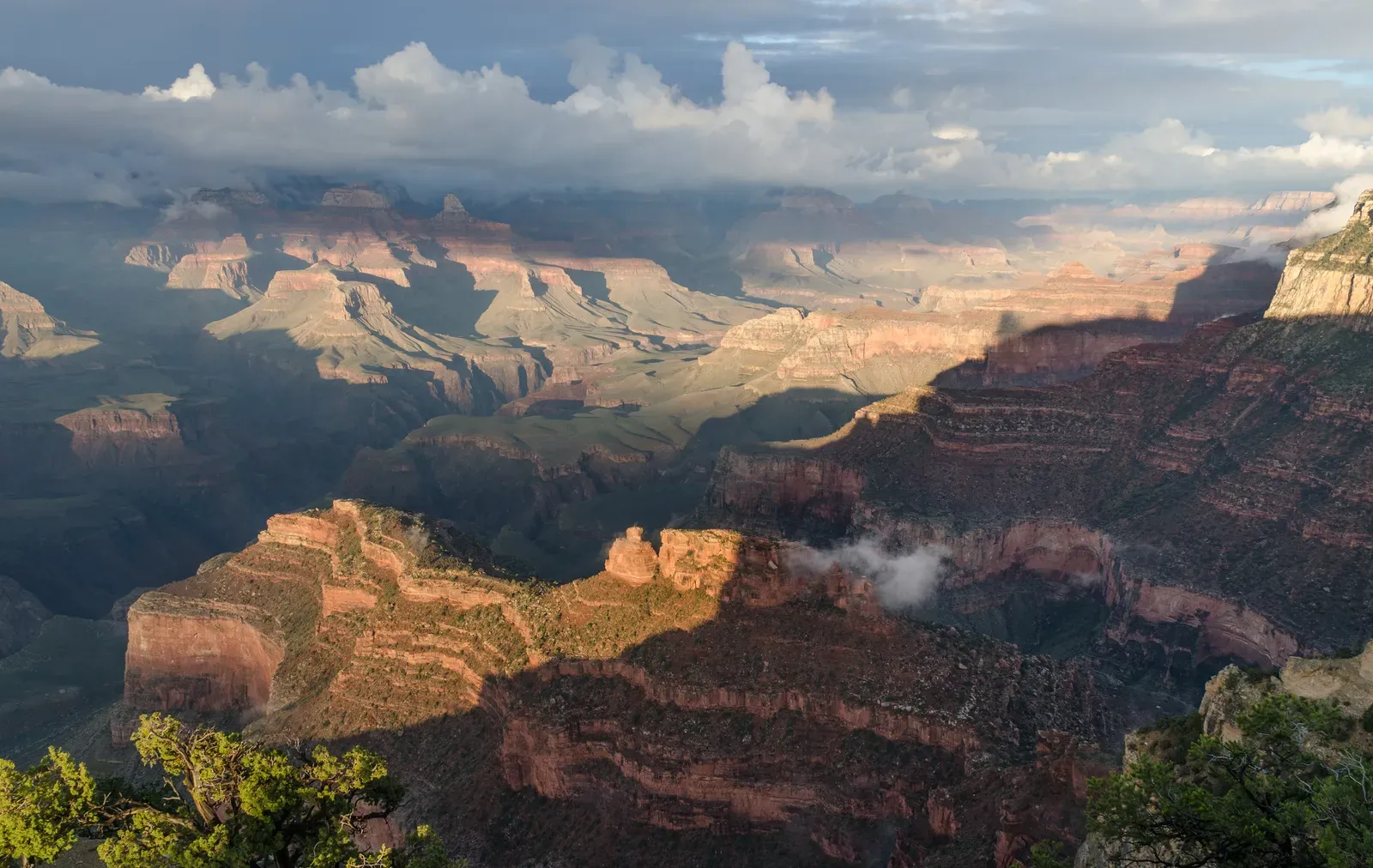
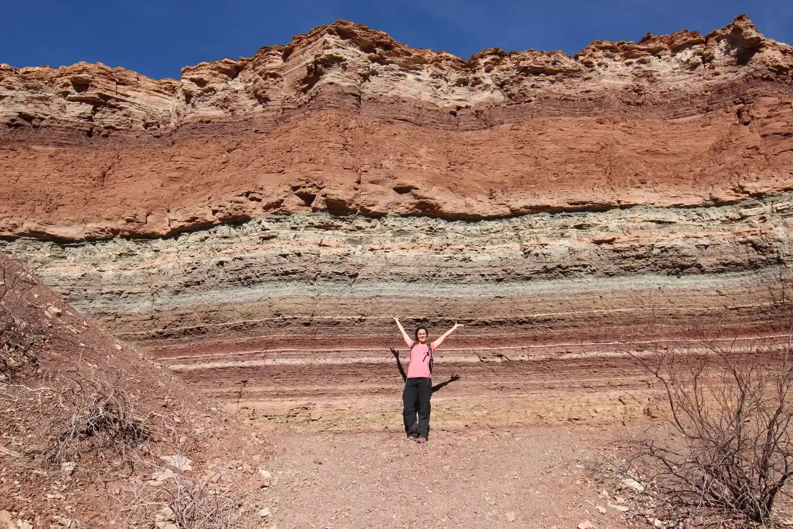
When you walk up to the edge of the Grand Canyon for the first time, the view almost does not feel real. You are looking across a chasm roughly about a mile deep and up to eighteen miles wide in places, carved mostly by the Colorado River over millions of years. Each horizontal stripe of color in the canyon walls is a rock layer that formed in a different ancient environment: shallow seas, coastal dunes, muddy tidal flats, even river systems that vanished long before humans appeared.
As you follow the layers from the top down, you are actually moving backward through time, way beyond the age of the dinosaurs. Near the bottom of the canyon, the rocks you see are more than a billion years old, formed when the Earth’s crust in this region was being stretched, uplifted, and reshaped. If you hike down the Bright Angel or South Kaibab trails, you experience that time travel with your feet, crossing rock layers that record vast climate shifts, changes in sea level, and multiple cycles of mountain building and erosion.
2. Yellowstone National Park – A Restless Supervolcano Under Your Feet
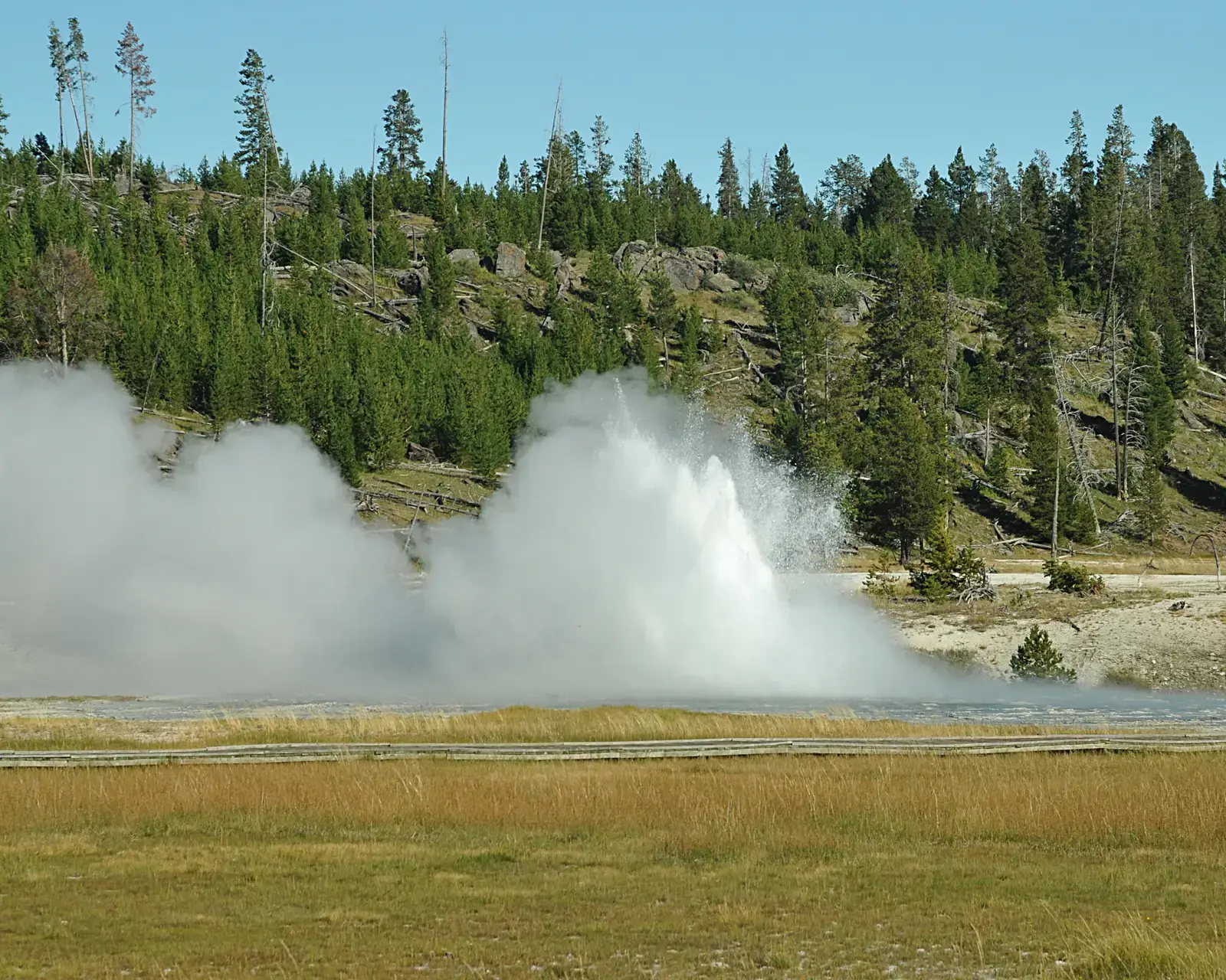
In Yellowstone, you are literally walking on top of one of the most powerful volcanic systems on Earth, even if it looks more like a peaceful forest and meadow landscape at first glance. The colorful hot springs, roaring geysers, and steamy fumaroles you see are all surface signs of a massive heat engine below, powered by a plume of hot rock rising from deep within the mantle. Instead of a steep volcanic cone, Yellowstone is a huge caldera, a broad collapsed depression formed by past explosive eruptions on an enormous scale.
As you stroll along the boardwalks at places like Old Faithful or the Grand Prismatic Spring, you are seeing how water circulates down into fractured rock, heats up near shallow magma or very hot rocks, and then blasts back to the surface. The park’s geology also tells you a story that stretches across the entire western United States: as the North American plate drifted over this hot mantle plume, past eruptions left a trail of older volcanic fields extending all the way into Idaho. Yellowstone reminds you that the planet’s surface is far from quiet, and that what looks like a stable landscape can actually be the breathing skin of a very active world.
3. Hawaiʻi Volcanoes National Park – Watching an Island Grow in Real Time
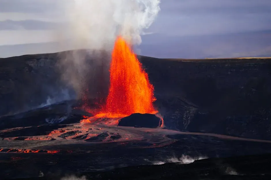
On the Big Island of Hawaiʻi, you get to see land being born right in front of you. Hawaiʻi Volcanoes National Park sits on one of the youngest parts of the Hawaiian island chain, built almost entirely from layers of solidified lava. Unlike explosive volcanoes that erupt thick, sticky magma, the volcanoes here mostly produce runny basaltic lava that can flow for miles, building wide, shield-shaped mountains like Kīlauea and Mauna Loa. Over time, countless overlapping flows have stacked up to form islands that can reach from the seafloor to heights taller than Mount Everest, if you measure from their submarine base.
When you watch a lava flow creep across a road or pour into the ocean, you are seeing the process that built the entire Hawaiian chain over millions of years. The islands line up in a neat arc across the Pacific because the Pacific tectonic plate keeps moving over a relatively fixed mantle hotspot, leaving behind a trail of older, eroded volcanoes like footprints on a conveyor belt. If you pay attention to the rugged textures of old flows, the black sand beaches made from shattered lava, and the way vegetation slowly colonizes fresh rock, you begin to understand how patient and persistent volcanic processes are in reshaping the Earth’s surface.
4. Badlands National Park, South Dakota – Fossil-Rich Remains of an Ancient World
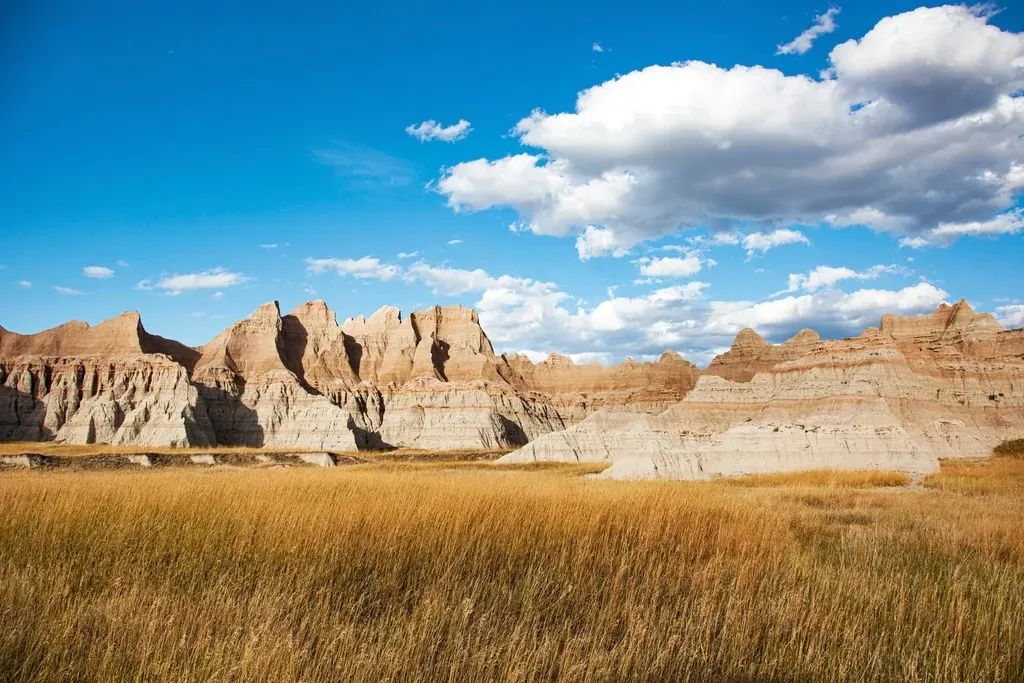
At first glance, the Badlands look harsh and almost alien, with jagged ridges, eroded spires, and colorful striped hills stretching toward the horizon. But when you walk the trails, you discover that these crumbly layers of sediment are actually the remains of lush ancient ecosystems. Roughly about thirty to forty million years ago, this area was home to rivers, floodplains, and grasslands where early horses, rhinoceros-like mammals, and saber-toothed predators once roamed. Over time, volcanic ash, river mud, and windblown dust buried their remains and preserved them as fossils.
Today, the dry climate and easily eroded rock make the Badlands one of the best natural fossil-exposing machines you could imagine. Every rainstorm, every freeze-thaw cycle chews away a little more sediment and reveals new bones and plant remains at the surface. As you trace the colored bands in the cliffs, you are moving through a record of changing climates and ecosystems, from wetter, more forested conditions to open grasslands. It is like reading a long, detailed diary of the Great Plains, written not with ink but with ash, mud, and time.
5. Mammoth Cave, Kentucky – Rivers That Moved Underground
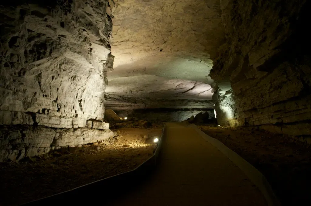
When you enter Mammoth Cave, you are stepping into one of the longest known cave systems on the planet, a hidden labyrinth carved inside layers of limestone. The story starts hundreds of millions of years ago, when this part of Kentucky lay beneath a warm, shallow sea where shells, corals, and other marine organisms piled up on the seafloor. Over time, those calcium-rich remains hardened into thick limestone beds. Much later, as the land rose and rivers began to flow across it, slightly acidic rainwater and groundwater started to seep into cracks and dissolve the limestone, slowly enlarging joints and bedding planes into tunnels.
As you move through the vast chambers and narrow passageways, you are really following the ancient routes of underground rivers that have long since shifted or disappeared. The layered ceilings, smooth walls, and occasional domes all record how water levels changed, how channels captured one another, and how the surface landscape above evolved. Stalagmites and stalactites in some sections remind you that caves continue to grow drop by drop, as mineral-rich water leaves behind tiny rings of calcite. Mammoth Cave shows you that erosion is not only a surface process; sometimes, whole landscapes are being quietly hollowed out from below.
Conclusion – Seeing the Landscape as a Living Story
When you connect the dots between these five places, you start to see America’s landscapes as pieces of a much bigger, ongoing story. The Grand Canyon gives you a vertical cross-section of deep time, Yellowstone and Hawaiʻi reveal the heat and motion inside the planet, the Badlands pull back the curtain on vanished ecosystems, and Mammoth Cave shows you the hidden work of water underground. Each site is different, but they all tell you the same thing: Earth has never been static, and neither has your own backyard, even if the changes are too slow for you to notice day by day.
If you bring this mindset with you on your next hike or road trip, even a roadside cliff or a strange-shaped hill can suddenly become fascinating. You might find yourself tracing rock layers with your eyes, wondering what kind of sea or forest used to be there, or picturing lava where a quiet pasture now sits. The more you learn to read the rocks, the more you realize you are not just living on Earth; you are living in the middle of a story that has been unfolding for billions of years and is still being written beneath your feet. The next time you pick up a rock, what chapter do you think you are holding?