You probably grew up thinking science already has a neat answer for every strange thing on Earth. Then you stumble across a photo of a perfect stone circle in the desert, a blood-red lake that seems to turn animals to stone, or a spiral of rock taller than a skyscraper and realize: a lot of the planet is still a giant question mark. That mix of beauty and uncertainty is exactly what you are about to walk into. In this tour, you are not just ticking off cool places to visit. You are stepping straight into scientific arguments, half-finished theories and puzzles that keep geologists awake at night. With each stop, you will see where the evidence ends, where speculation begins, and how even in 2026 there are corners of Earth that shrug off tidy explanations. By the time you reach the last formation, you may look at your own landscape a little differently and wonder what mysteries you are walking over every day.
1. Racetrack Playa’s “Sailing Stones,” Death Valley, USA
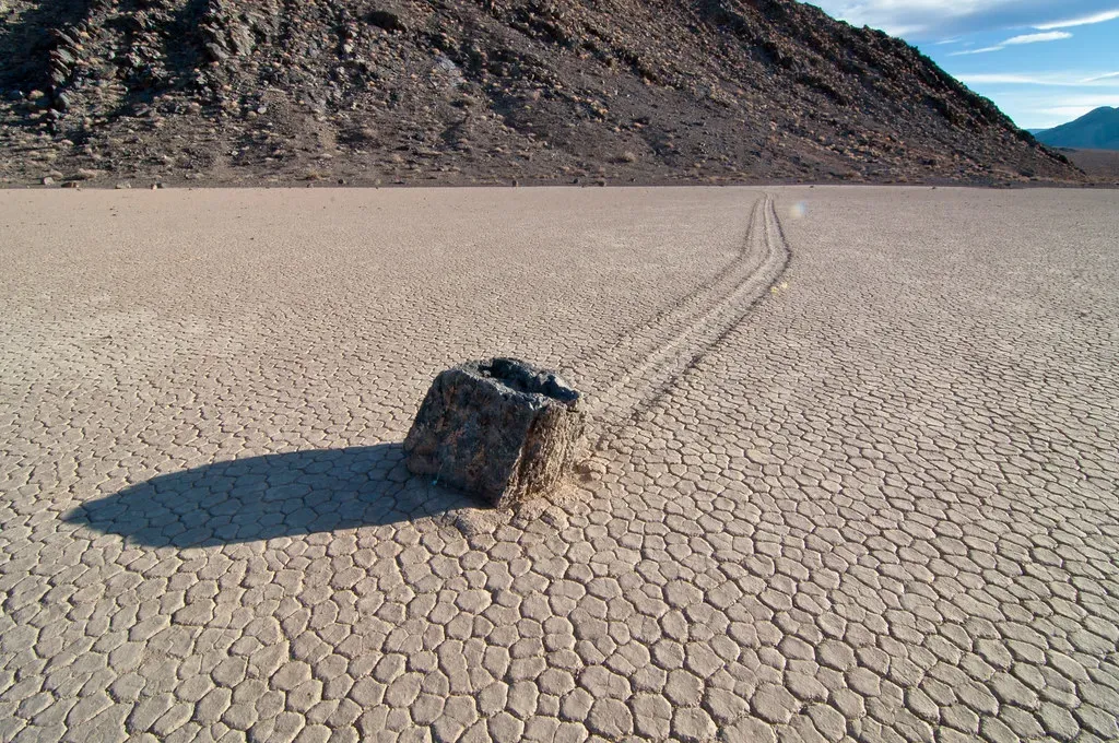
You stand on a dry, cracked lakebed in one of the hottest places on Earth and see something that should not exist: heavy rocks that have carved long, graceful tracks across the mud as if they sailed like boats. You can follow a stone’s path for dozens of meters, curving and zigzagging, with no footprints, no obvious slope, and no sign of anyone dragging them. For decades, people blamed magnetic fields, pranksters, and even mysterious forces because nothing about big rocks gliding across a flat desert felt ordinary.
Today, you are told a story involving thin winter ice, shallow water, and just the right push of wind, and it does explain a lot of what you see. Under rare conditions, sheets of ice can form, break up, and nudge the stones across the slick mud, leaving those eerie trails behind. The catch is that these perfect conditions are extremely unusual, and you do not get to watch them often, which means the phenomenon still feels half-understood and almost mythical. Standing there, staring at silent rocks that once moved like ghosts across the valley floor, you realize that “partly solved” still feels a lot like “mysterious” when you watch the end result with your own eyes.
2. The Richat Structure, “Eye of the Sahara,” Mauritania
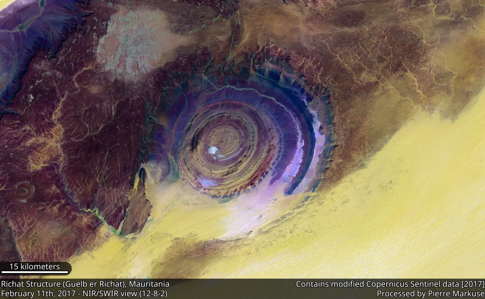
From the ground, you just see rock and desert. But if you look from space, you suddenly stare into what looks like a gigantic stone bullseye burned into the Sahara: ring after ring of rock forming a perfect circular “eye” more than 25 miles across. You might have heard internet whispers calling it Atlantis, a crashed UFO, or the scar of some ancient megablast. When you finally learn scientists call it the Richat Structure and still argue about the details of how it formed, it becomes even more intriguing.
Most geologists lean toward a natural explanation: a huge dome of rock uplifted from below and then sculpted into concentric circles by millions of years of erosion. That story makes sense on paper, but when you lay a photo of the Eye of the Sahara on your screen it feels almost too symmetrical, too symbol-like, as if the planet was doodling. You are left in this odd in‑between place: the broad strokes sound settled, yet key pieces – exactly how it rose, how the rings lined up so cleanly, what role underground fluids or volcanism really played – are still debated. The more you learn, the less it looks like a conspiracy and the more it feels like nature showing off in a way your brain has trouble filing under “normal.”
3. Patomskiy Crater, Siberia, Russia
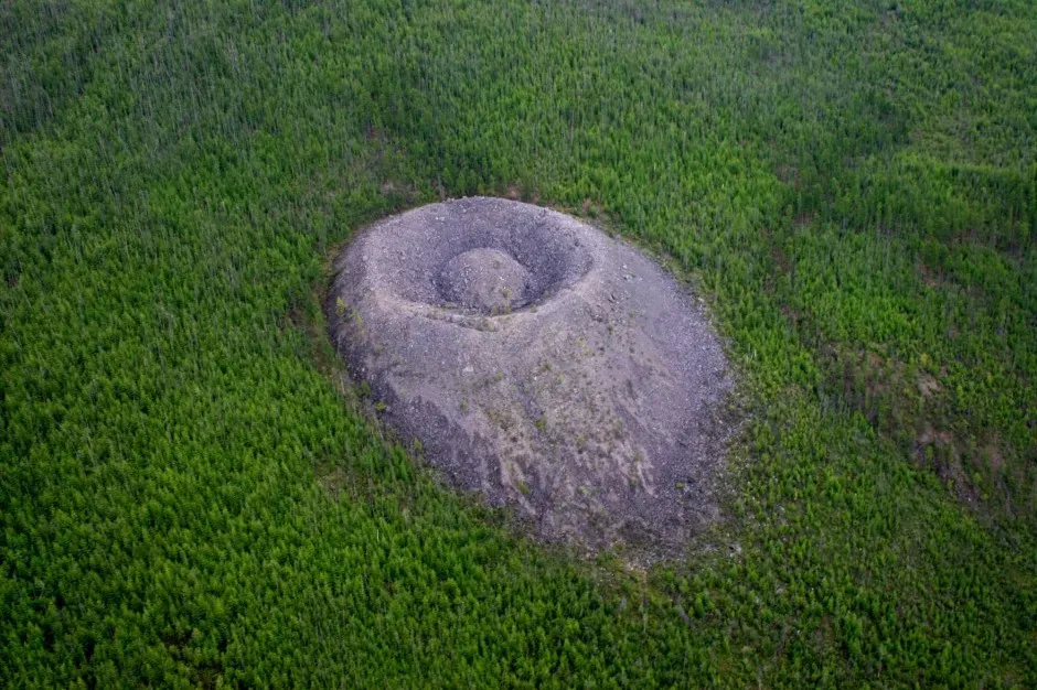
Imagine hiking through dense Siberian forest and suddenly stepping into a clearing where the ground rears up into a massive cone of gray rock, like a frozen splash. That is Patomskiy Crater: a steep mound with a hollowed center, discovered in the mid‑1900s and quickly wrapped in rumors of curses, missing animals, and strange feelings of dread. Locals once called it the “Fire Eagle’s Nest,” and honestly, when you see that pale cone shouldering out of the dark taiga, you understand why myths got there before geologists did.
Scientists have thrown almost every idea at it: a meteorite impact, a mini volcano, a gas explosion, even something linked to deep-seated tectonic activity. Each hypothesis explains some features and then stumbles on others – the rock types, the shape, the way the structure seems younger inside than outside. You are left with a formation that looks like an impact crater that forgot to leave clear impact evidence, or a volcano that never bothered to erupt properly. When you picture teams camping there, instruments spread out, and still going home without a firm answer, you realize this remote cone is not just eerie folklore; it is a genuine geological headache.
4. Lake Natron, Tanzania
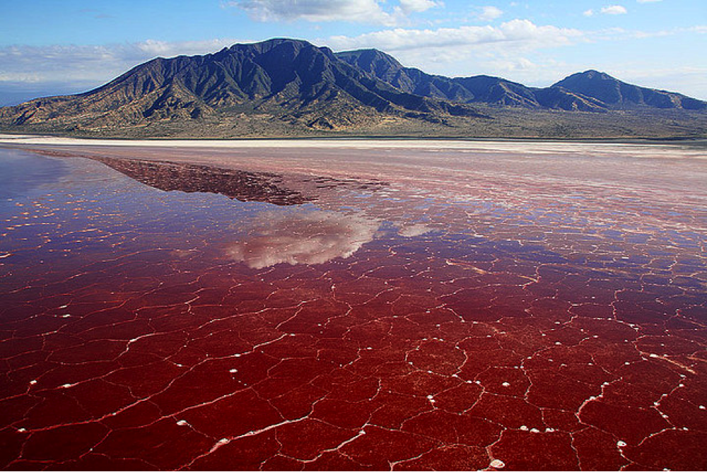
When you first see photos of Lake Natron, the colors hit you: streaks of deep red, orange, and pink stretching across a shallow lake at the edge of a volcano. Then you notice something darker – images of birds and other animals that look eerily “turned to stone” along its shores. The truth is more nuanced than the horror stories, but as you stand there smelling the mineral-rich air, you can feel why this place has become legend. It looks like a lake designed by someone with a flair for the dramatic.
The water is extremely alkaline and hot in places, fed by mineral springs and volcanic chemistry that create a kind of natural caustic bath. You are told that some animals that die here can become coated and preserved in mineral crusts, and that microscopic life, not lifelessness, actually thrives in these harsh conditions. But big questions linger: Why does the lake’s color shift so dramatically at times? How will changing rainfall and temperature alter its chemistry and the fragile web of life that depends on it? Walking its shore, you are forced to admit that this “deadly” lake also holds a living laboratory whose future and fine details still sit beyond clean explanation.
5. The Moeraki Boulders, New Zealand
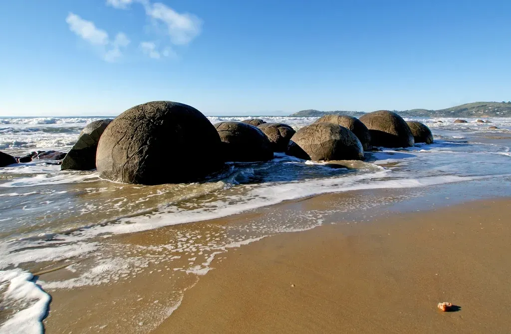
Picture a quiet New Zealand beach scattered with enormous stone spheres, some the size of small cars, cracked like dragon eggs. You wander between them at low tide, running your hand across their smooth, rounded surfaces and wondering who dropped a set of perfectly imperfect stone marbles here. Locals have their own traditional stories, and standing there you feel how easy it is to see these boulders as frozen characters in some myth that never got written down.
Geologists will tell you these are concretions: mineral-rich water seeping through mudstone, slowly cementing sediment around a core until you end up with a buried sphere that the sea later reveals. That explanation is solid as far as it goes, but if you dig deeper you find active debates about exactly how long they took to form, what controlled their near-perfect shapes, and why some coastlines host a handful while others collect almost eerie crowds of them. You leave the beach with a new appreciation for how something as simple as “mud plus minerals plus time” can still generate shapes that feel suspiciously deliberate.
6. The Stone Forest of Shilin, China

If you walk into Shilin in Yunnan, you feel less like you are entering a forest and more like you are stepping into a world where trees evolved into stone. Blade-like towers of limestone thrust up from the ground, some taller than apartment blocks, packed so tightly you can weave through them like city alleys. You know, intellectually, that rainwater and groundwater have been dissolving this rock for ages, carving out vertical channels and leaving harder pillars behind. But emotionally, it feels like you are navigating the ruins of some alien metropolis.
Karst landscapes – the technical name for this kind of sculpted limestone terrain – are “explained” in broad terms, yet every specific stone labyrinth like Shilin still raises messy questions. Why did erosion here produce narrow, blade-thin towers rather than the arches, sinkholes, and caves you see elsewhere? What tiny differences in rock layers, fractures, climate history, and water chemistry pushed this forest toward such extreme verticality? When you look up at those jagged silhouettes against the sky, you realize you are walking through the outcome of countless small decisions by water and time that no model fully captures yet.
7. The Giant’s Causeway, Northern Ireland
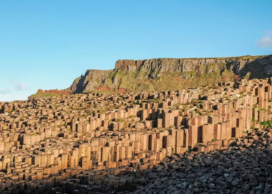
When you first see the Giant’s Causeway, you might catch yourself counting sides. The coast is paved with tens of thousands of basalt columns, most of them neat hexagons fitted together like a stone honeycomb, stepping down into the North Atlantic. You can walk along them like a road, and it is almost impossible not to picture a mythic builder stomping each block into place. The local legends about giants feel less like stories and more like a very reasonable reaction to something your eyes do not quite trust.
The scientific story points to ancient lava cooling and contracting, cracking into polygonal columns much the way drying mud splits into shapes. That process has been reproduced in other volcanic landscapes, and it definitely explains the basics. What keeps the Causeway feeling partly mysterious is the scale and precision: the sheer number of columns, their height, their alignment, and how such tidy order emerged from a messy eruption and cooling history. As you sit on one of the columns, foam spraying your legs, you sense that the physics is broadly understood, yet the exact choreography that turned chaos into this geometric masterpiece still contains more questions than your guidebook admits.
8. Devil’s Tower, Wyoming, USA
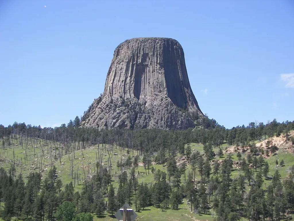
Driving through rolling Wyoming hills, you suddenly see it: a colossal pillar of rock rising straight out of the landscape, ribbed with vertical grooves like a bundle of stone pipes. Devil’s Tower looks like a forgotten fortress or the stump of some impossible tree, cut off and left to weather. When you finally stand at its base and tilt your head back, it feels impossibly steep and improbably lonely, and you can understand why it became a sacred place long before it became a national monument.
Most geologists agree you are looking at igneous rock – cooled magma – but they do not fully agree on what shape that magma originally took. Was it the hardened core of a volcano whose outer layers eroded away, or a deep intrusion that never reached the surface? The striking column-like pattern is linked to cooling fractures, similar to the Giant’s Causeway, yet how exactly this one mass produced such high, continuous columns is still being explored. As you trace the grooves with your eyes, you feel like you are reading a story in an unknown script: you recognize the letters but not quite the plot.
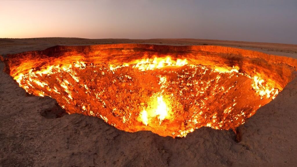
9. The Darvaza Gas Crater, “Door to Hell,” Turkmenistan
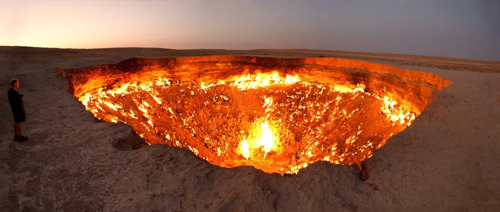
In the middle of the Karakum Desert, night falls and the horizon suddenly burns: a huge circular pit of roaring orange flames, as if someone opened a hatch straight into the planet’s furnace. You walk closer and feel waves of heat against your face, hear the low roar, and smell the sharp tang of burning gas. Local people call it the “Door to Hell,” and as you stare into it, you cannot help but agree that the nickname feels less like drama and more like accurate description.
The short version says this started as a collapsed gas field, set on fire decades ago to burn off dangerous methane and somehow left to keep burning. But if you try to pin down exactly when it collapsed, who ordered it ignited, and why it was never sealed, you run into conflicting accounts and missing records. Even the age of the fire is still debated. You are left with a modern geological oddity that straddles the line between human accident and natural structure, quietly feeding off underground gas with no agreed‑upon end in sight. Looking into that inferno, you are reminded that not all of Earth’s unsettling formations are ancient; some mysteries are unplanned side effects of your own species poking the ground.
10. Fairy Circles of Namibia and Western Australia
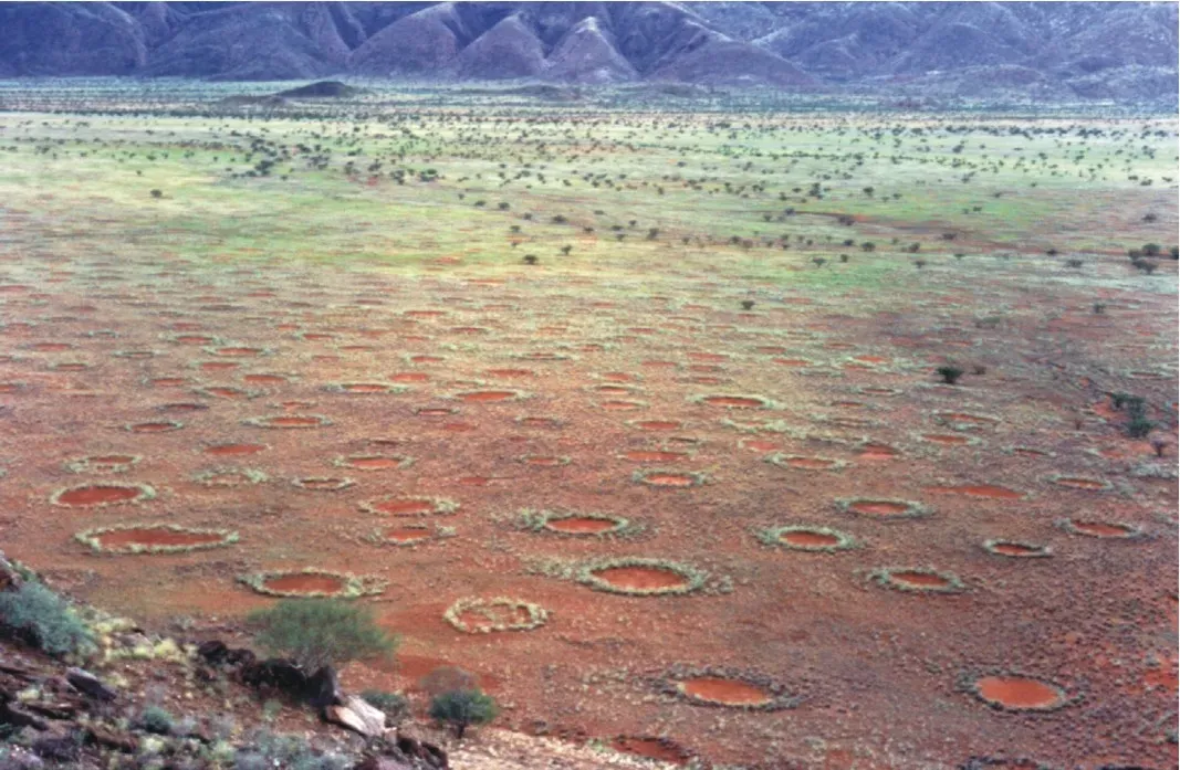
Fly over parts of the Namib Desert or certain Australian outback plains and you see something uncanny: regular polka dots of bare ground scattered across the landscape, each ringed by grasses, as if some invisible artist stamped thousands of circles onto the earth. When you walk among them, each circle looks deceptively simple – just a patch of emptiness surrounded by living plants – but together they form patterns so orderly that your brain instinctively reaches for an intelligent designer. Instead, you are told no one fully agrees on the designer at all.
Over the years, explanations have bounced between plant self-organization, termite engineering, soil toxicity, and combinations of all three tied to scarce water. Some studies show certain patterns matching vegetation feedback models, others dig up termite galleries, and still others find evidence that different regions might obey different rules altogether. You end up with a humbling conclusion: these circles may reflect a tug‑of‑war between biology, climate, and soil that you do not yet know how to untangle. Walking away, you realize that even something as ordinary as grass and dirt can arrange itself into patterns that feel as mysterious as any alien crop circle.
When you string all these places together – the moving rocks, the stone eye in the desert, the flaming pit, the haunted crater and the perfect basalt pavements – you start to notice a pattern that has nothing to do with geometry. Each formation sits at the edge of what you can currently explain: partly mapped by science, partly clouded by missing data, and heavily colored by the stories people wrap around them. Your world is not a finished textbook; it is more like a draft manuscript with entire chapters still scribbled in pencil.
The next time you see an odd rock in your local park or a strange pattern on a satellite map, you might feel a quiet thrill instead of brushing it off. You are living on a planet that still hides questions big enough to puzzle experts and spectacular enough to stop you in your tracks. Maybe the better question is not how many mysteries are left, but which one you are going to go and stand in front of first – and when you do, what do you think your own theory will be?