You grow up being told that science, engineering, and precision are mostly modern achievements. Then you stand in front of an ancient mound, a stone wall, or a carved temple in the Americas and realize something unsettling: someone, long before textbooks and satellites, already knew how to read the sky, shape the land, and move impossible amounts of stone and earth. These places do not just feel old; they feel deliberate, like pages of a manual you were never meant to see.
As you travel through these ruins in your mind, you start to sense a pattern. Across thousands of miles and hundreds of years, different cultures aligned monuments to solstices, tracked planetary cycles, and engineered cities with eerie mathematical order. You do not need to believe in wild conspiracy theories to feel that a lot of hard knowledge has been forgotten or ignored. When you look closely, these structures challenge your assumptions about what people in the ancient Americas understood – and how much of that wisdom you might still be underestimating today.
1. Teotihuacan’s Avenue of the Dead: A City Planned Around the Sky
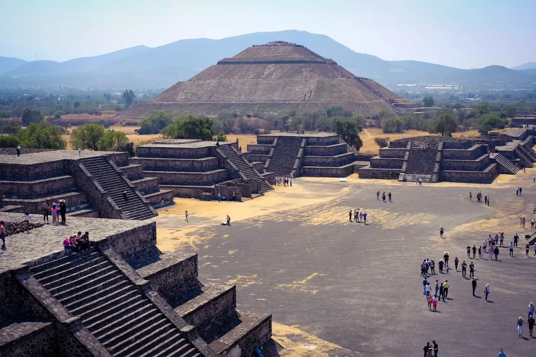
When you walk along the Avenue of the Dead at Teotihuacan, near today’s Mexico City, you are not just strolling through an old street; you are walking inside a gigantic piece of celestial engineering. The main road runs for roughly two kilometers and is flanked by massive pyramids – the Pyramid of the Sun, the Pyramid of the Moon, and other ceremonial complexes – that together form a carefully laid-out urban grid. Archaeologists have shown that the avenue is tilted a bit off true north, not by accident but in a way that lines up with key solar and possibly stellar events, suggesting that the entire city was oriented with the heavens in mind. ([en.wikipedia.org](https://en.wikipedia.org/wiki/Teotihuacan?utm_source=openai))
You can imagine city planners standing on that plateau nearly two thousand years ago, watching the sun and bright stars rise and set, then pegging the bones of an entire metropolis to those movements. The scale is staggering: tens of thousands of residents, marketplaces, apartment compounds, and temples all conforming to a scheme that blends religion, astronomy, and political power. When you see a city laid out with this level of geometric and cosmic precision, you realize you are not looking at guesswork; you are looking at a tradition of careful observation and long-term tracking of the sky that rivals the planning behind many modern capitals.
2. Chichen Itza’s El Caracol: The Spiral Tower That Watched the Planets
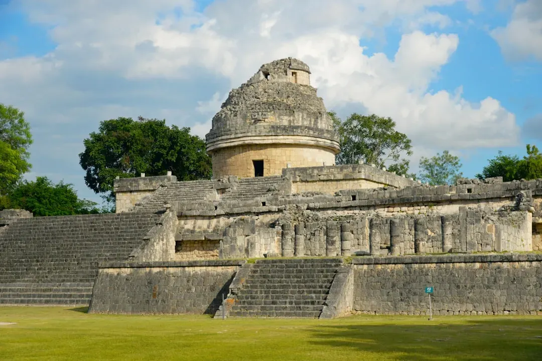
If you ever visit Chichen Itza on the Yucatán Peninsula, your eyes go first to the big step pyramid, El Castillo. But if you are curious, you wander a bit farther and find a strange, round building on a rectangular base known today as El Caracol, the “snail,” because of its spiral interior staircase. At first glance it looks like an odd little tower, but studies suggest it functioned as an observatory, giving Maya astronomer-priests clear sightlines to the horizon across the region’s flat landscape. Openings and angles in the structure appear to align with celestial events such as the movements of Venus and key solar positions, implying that this was not a random tower but a purpose-built instrument of sky-watching. ([en.wikipedia.org](https://en.wikipedia.org/wiki/El_Caracol%2C_Chichen_Itza?utm_source=openai))
When you stand in a place like that, you realize you are inside a building designed to solve a very practical problem: how do you keep long-term track of cycles you can only see by patiently watching the sky, night after night, year after year? The Maya used such knowledge to time agriculture, rituals, and political acts, embedding astronomy into daily life. You might be used to thinking of observatories as domes with telescopes, but El Caracol reminds you that you can build a working observatory out of stone, geometry, and patience. It suggests a culture that treated the sky not as a backdrop, but as a readable and predictable system worth encoding in architecture.
3. Chichen Itza’s El Castillo: A Pyramid That Becomes a Serpent of Light
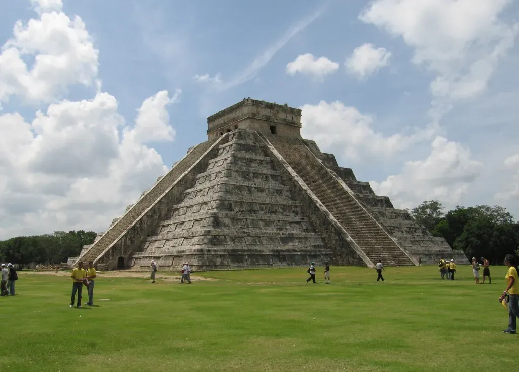
El Castillo, also called the Temple of Kukulcan, does more than just stand impressively at the center of Chichen Itza; it moves with the year in a way you can literally see. During the spring and autumn equinoxes, when the sun hits just right in the late afternoon, a pattern of light and shadow appears on the pyramid’s staircase. Triangular shadows from the stepped terraces stack up along the northern balustrade and seem to form the body of a serpent slithering down to a carved serpent head at the base. This effect is not a cosmic accident; the angles of the steps and the orientation of the pyramid create a predictable, dramatic light show tied to the turning of the seasons. ([en.wikipedia.org](https://en.wikipedia.org/wiki/El_Caracol%2C_Chichen_Itza?utm_source=openai))
When you see that play of light and shadow, you are watching astronomy, geometry, and myth welded into one performance. You are also watching a kind of public calendar: the return of the serpent of light would have been a powerful signal for ceremonies and farming activities. The number of steps – often interpreted as matching the days of the solar year when you count all sides and platforms – reinforces the idea that this structure encodes time in stone. You realize that you are dealing with people who did not just know the solar year abstractly; they turned it into a living, visible event that could awe a whole crowd at once.
4. Nazca Lines in Peru: Geoglyphs That Turn the Desert into a Canvas
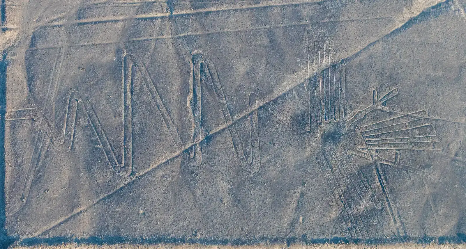
Imagine climbing into a small plane over the coastal desert of southern Peru and suddenly seeing enormous animals, straight lines, and geometric shapes stretching across the ground for kilometers. The Nazca Lines are not visible as coherent figures from the ground level the way you might expect; they really come to life only from the air or nearby hills. Ancient people removed dark stones from the desert surface to reveal lighter soil beneath, carving out hummingbirds, spiders, monkeys, and long, almost perfectly straight lines that can run for several kilometers. Some of these lines and shapes align broadly with directions of the solstices or other solar positions, hinting that you are looking at a landscape-scale experiment in orientation and perhaps ritual pathways. ([en.wikipedia.org](https://en.wikipedia.org/wiki/Cahokia_Woodhenge?utm_source=openai))
Even if you set aside speculative theories, you can see right away that you are dealing with impressive surveying skills and a clear understanding of how to maintain straight lines over long distances without modern equipment. The builders managed this in a harsh, dry environment, using simple tools but achieving a precision that leaves you wondering how they trained, organized, and passed on this knowledge. You might never know whether particular figures correspond to specific constellations or calendar markers, because the evidence is debated and fragmentary, but you can confidently say that the Nazca turned their desert into a carefully planned ritual and possibly astronomical landscape, one that still resists easy explanation.
5. Sacsayhuamán Above Cusco: Stone Walls That Should Not Fit So Well
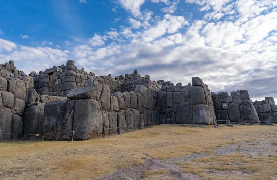
When you walk up to the cyclopean walls of Sacsayhuamán overlooking Cusco in Peru, your brain quietly protests. The stones are huge – some weighing many tons – and yet they fit together with such tight precision that you often cannot slide a knife blade between them. The blocks have irregular, multi-sided shapes, and yet each joins its neighbors in a way that locks the wall together without mortar. This is not just brute-force stone piling; it is the result of a sophisticated understanding of stone shaping, load distribution, and perhaps even seismic resilience, since the region is earthquake-prone and these walls have survived repeated quakes. ([en.wikipedia.org](https://en.wikipedia.org/wiki/Cahokia_Woodhenge?utm_source=openai))
As you run your hand along the surface, you realize that every angle had to be measured and re-measured, every block repeatedly tested against its neighbors until the fit was exact. You do not need to invoke lost machines to appreciate how advanced this is; it already demands a body of practical engineering knowledge, honed by generations of trial and error, and a system for coordinating labor on a massive scale. The zigzag plan of the walls may have had symbolic meaning, but it also creates stability and depth, like the teeth of a giant stone comb gripping the hillside. In Sacsayhuamán, you see how ancient builders turned sheer stone into something almost like a living skin stretched perfectly over a skeleton of ideas.
6. Machu Picchu: Terraces, Springs, and a City That Talks to the Mountains
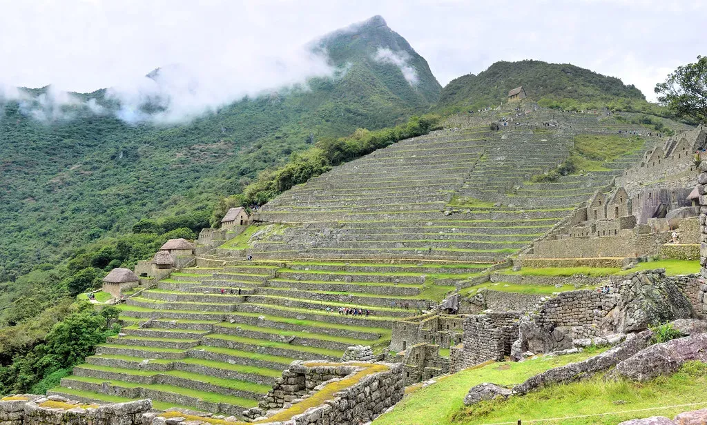
Machu Picchu is often treated like a postcard backdrop, but if you pay attention, it reads like a textbook of integrated engineering. The site sits on a narrow ridge between steep Andean peaks, in an area with heavy rainfall and landslide risk, yet the Inca built a complex of stone houses, temples, and plazas that still stands centuries later. Beneath the visible buildings lies an underworld of drainage systems, retaining walls, and precisely cut terraces that manage water and stabilize the slopes. Spring-fed fountains are channeled through narrow carved channels, delivering clean water throughout the site while excess runoff is quietly directed away. ([en.wikipedia.org](https://en.wikipedia.org/wiki/Cahokia_Woodhenge?utm_source=openai))
As you walk along the terraces, you realize they are not just for farming; they are also earthworks that reduce erosion, control microclimates, and anchor the city to its precarious ridge. Some structures are oriented in ways that interact with solstice sunrises and surrounding sacred peaks, linking the architecture to both astronomy and the local landscape. You find yourself in a place where hydrology, geology, agriculture, and cosmology are all folded into the same design. If you tried to build something similar today, you would call it sustainable design or landscape engineering. Here, you see the same principles at work centuries earlier, preserved in stone instead of diagrams.
7. Tiwanaku’s Kalasasaya and Sun Gate: Measuring Time on the Altiplano
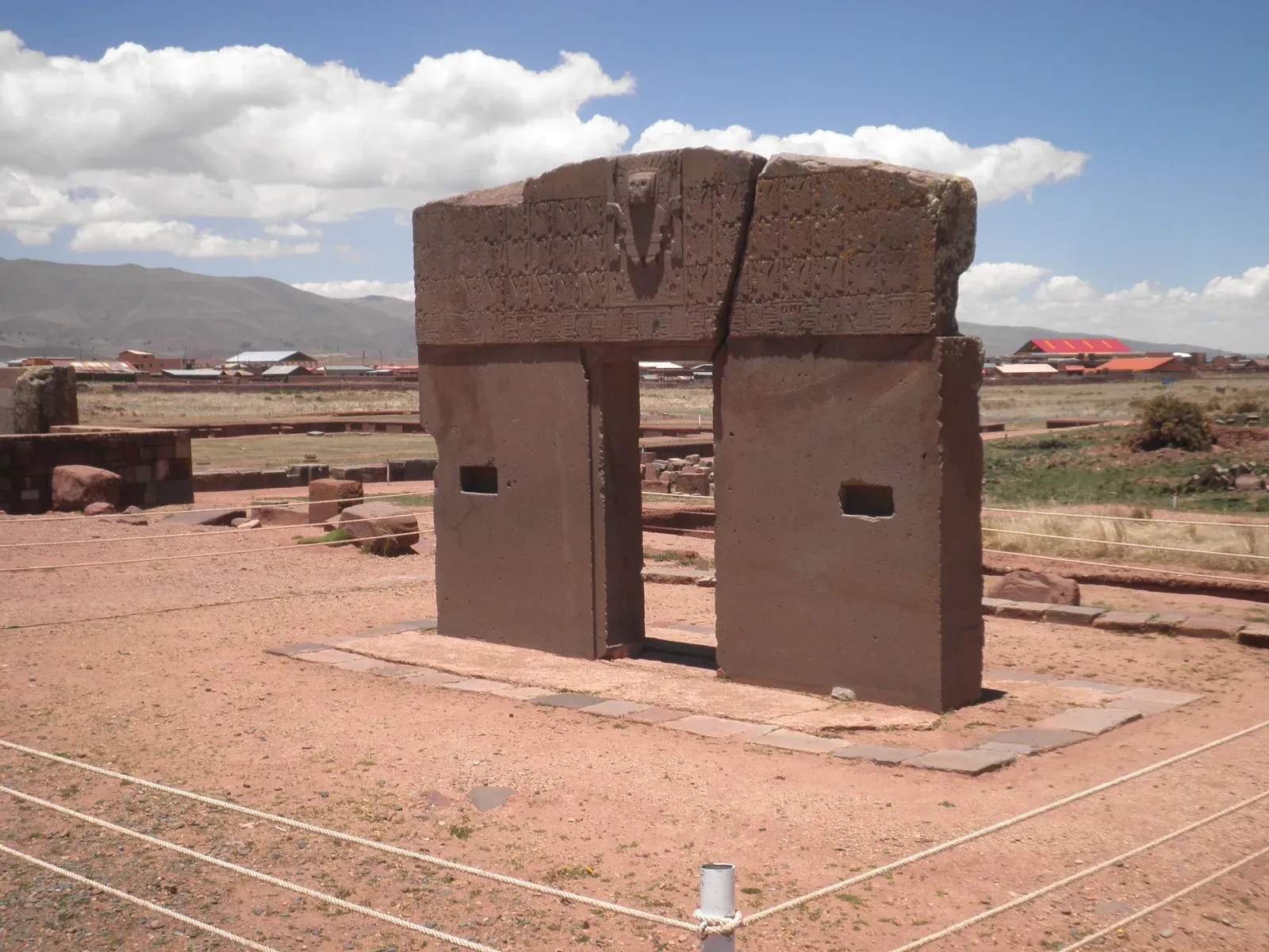
High on the Bolivian altiplano, near Lake Titicaca, the ruins of Tiwanaku feel stark and otherworldly, but if you stand inside the Kalasasaya temple you begin to sense how carefully it was tuned to the sky. The rectangular complex is bordered by standing stones and walls whose layout appears to mark important solar events, such as solstices and equinoxes, through the play of light and shadow at dawn or sunset. Nearby, a single carved monolithic doorway known as the Sun Gate features intricate iconography that many researchers think encodes calendrical or astronomical information, though not all details are fully understood. ([en.wikipedia.org](https://en.wikipedia.org/wiki/Cahokia_Woodhenge?utm_source=openai))
What you are seeing is a culture using architecture as a giant, open-air instrument to track the passage of time in a region with harsh seasons and clear horizons. The precision required to repeatedly hit solar targets year after year suggests long observation and shared methods for aligning structures with the motions of the sun. Even though some popular claims about Tiwanaku’s age and purpose are exaggerated, the core fact remains: people here built stone complexes that doubled as a working calendar and ceremonial stage. When you stand where they once watched the sun slide into a notch on the horizon or between pillars, you are participating in a very old habit of turning the sky into a clock you can walk through.
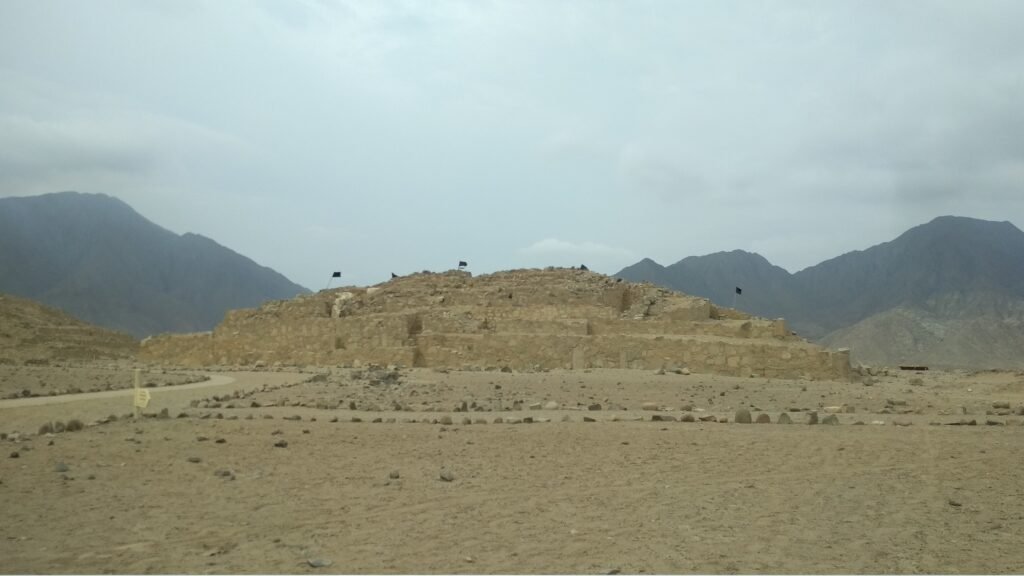
8. Cahokia’s Monks Mound: An Earthen Pyramid with a Hidden Logic
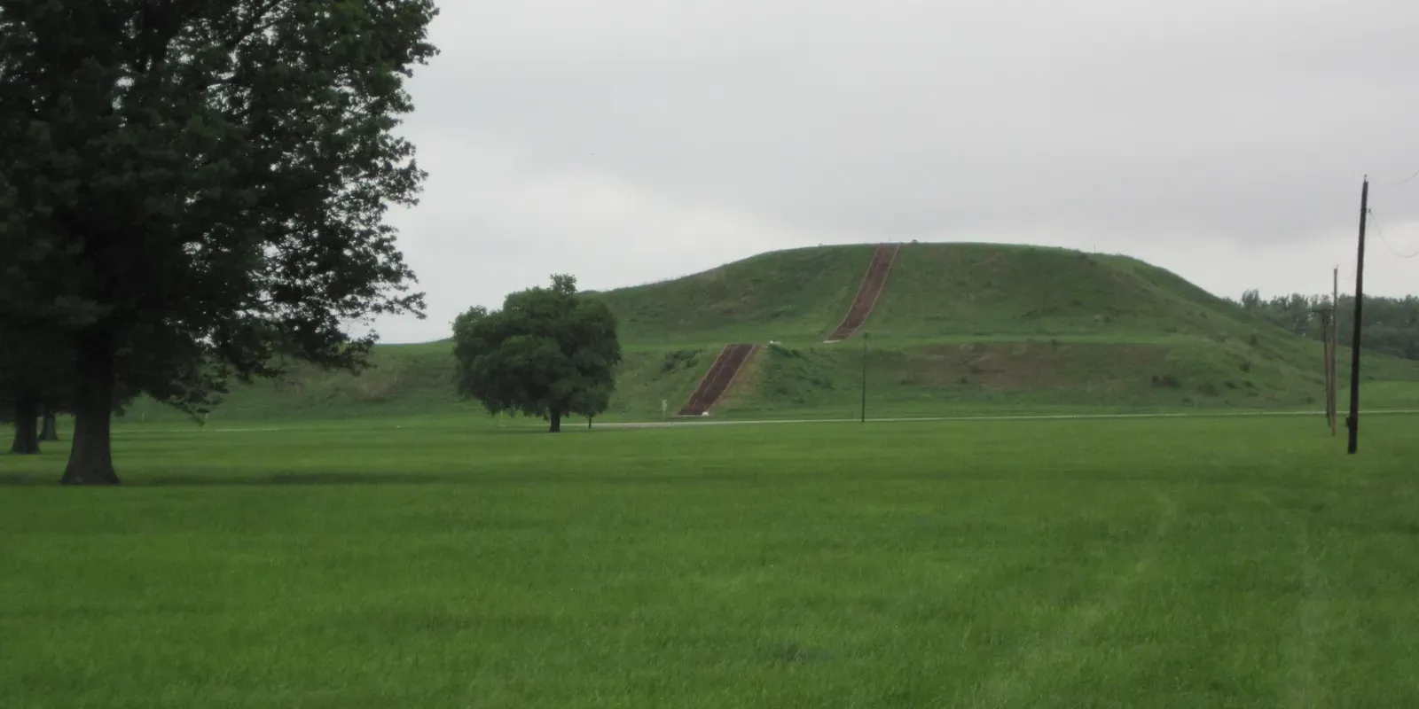
On the Mississippi floodplain near present-day St. Louis, you find something that completely rewrites what you think you know about ancient North America: the sprawling city of Cahokia. At its heart rises Monks Mound, the largest pre-Columbian earthwork in the Americas and a true pyramid of packed earth rather than stone. It was built in stages between roughly the tenth and thirteenth centuries, with layers of carefully selected and compacted soils, terraces, and ramps forming a platform that once supported important buildings. Engineers today liken it more to an earthen dam than a simple heap of dirt, because the builders clearly understood how to keep such a massive structure stable on soft ground. ([en.wikipedia.org](https://en.wikipedia.org/wiki/Cahokia?utm_source=openai))
As you climb to the top, you can see how the mound anchors a wider urban plan: plazas, secondary mounds, and processional ways radiate outward in patterns that reflect social hierarchy and ritual importance. There is evidence that certain elements of the complex align with cardinal directions and possibly celestial events, hinting again at a blend of surveying, astronomy, and political theater. The people of Cahokia left no written records, but in the way they moved millions of baskets of soil and shaped this immense platform, they left a silent testimony to their engineering and organizational skills. When you stand up there, looking over the modern landscape, you might feel like you are standing on the top of a forgotten capital city that once rivaled or surpassed many medieval European towns in size.
9. Cahokia Woodhenge: A Timber Calendar Hidden in the Prairie
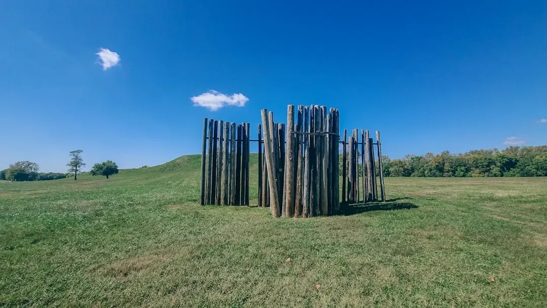
Not far from Monks Mound, archaeologists uncovered something that at first looked like nothing more than a ring of postholes. When they mapped the pattern, though, they realized they had found a series of large timber circles, now known as Woodhenge. These circles were built and rebuilt over time, each consisting of dozens of tall posts placed at carefully calculated intervals. When you plot the positions of key posts against the horizon, alignments appear that match solstice and equinox sunrises, suggesting that the circles functioned as gigantic calendars or observatories used to mark the turning of the year and perhaps to schedule ceremonies and agricultural activities. ([en.wikipedia.org](https://en.wikipedia.org/wiki/Cahokia_Woodhenge?utm_source=openai))
If you picture yourself standing at the center on a frosty morning, watching the sun rise exactly over a particular post, you can feel how powerful that moment would be. Leaders could literally stand in the right place at the right time and demonstrate command over the rhythms of nature, reinforcing their authority. The posts themselves have long since vanished, but the pattern of their sockets in the ground preserves the geometry and the intention. To you, Woodhenge shows that complex astronomy in the Americas was not limited to stone temples in the tropics; it was also alive in wooden circles on a Midwestern prairie, recorded not in ink but in dirt and sunlight.
10. Palenque’s Temple of the Inscriptions: Architecture as a Book of Time
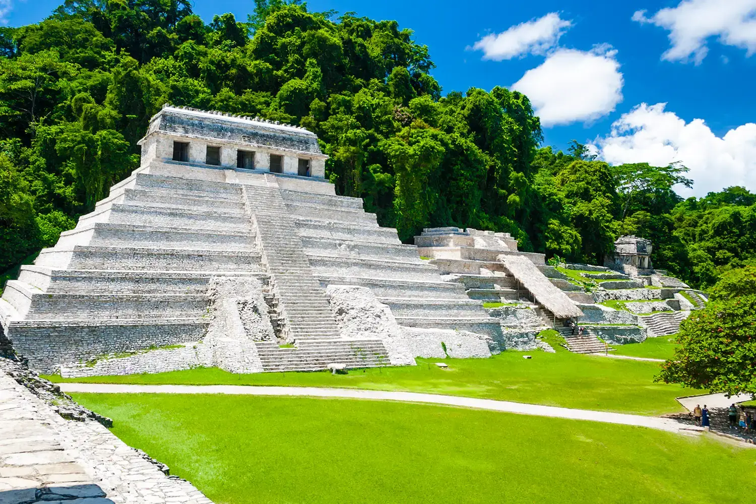
In the jungle of southern Mexico, the Maya city of Palenque hides a structure that pulls you directly into their way of thinking about history and time: the Temple of the Inscriptions. At first it looks like another stepped pyramid topped by a temple, but inside, carved stone panels record long sequences of dates in the Maya Long Count calendar, tracing royal lineages and mythic events over centuries. A hidden stairway leads down to an elaborate royal tomb, tying together architecture, writing, astronomy, and political legitimacy in one carefully composed monument. ([arxiv.org](https://arxiv.org/abs/1601.03132?utm_source=openai))
When you consider how the Maya tracked solar, lunar, and planetary cycles, then encoded that knowledge into their calendar system and inscribed it on monuments like this, you realize you are seeing a complete intellectual ecosystem. The temple is not just a burial place or a platform for rituals; it is also a physical anchor for a complex understanding of cyclical and linear time. As you read about their ability to predict eclipses and their sophisticated mathematical treatment of long spans of time, you see how deeply they wove astronomical knowledge into their sense of identity and destiny. The stones of the Temple of the Inscriptions remind you that for the Maya, advanced knowledge was not an abstract pursuit; it was the backbone of religion, politics, and memory.
Conclusion: What These Ancient Structures Really Tell You
When you step back and look at all these structures together – avenues aligned with stars, pyramids that perform with the sun, terraces and mounds that tame difficult landscapes – you start to notice a recurring theme. Across the Americas, different cultures used architecture as a tool to understand and manage their world. They tracked celestial cycles to guide planting and ritual, engineered earth and stone to survive floods and earthquakes, and built cities and temples that doubled as calendars, observatories, and symbols of power. None of this requires you to imagine mysterious lost civilizations; it simply asks you to respect how far careful observation, shared knowledge, and organized labor can go.
At the same time, you also sense how much has been lost: oral teachings that never made it into writing, techniques that were passed down hands-on and then abruptly cut off, meanings of alignments and symbols that we can only half reconstruct. When you visit or even just read about these sites, you are looking at the solid remnants of intellectual traditions that were every bit as serious and technical as many modern ones, even if they were expressed in different ways. Maybe the most practical lesson for you today is this: advanced knowledge does not have to look like a lab or a laptop; it can be baked into earth, carved into stone, and traced in the path of the setting sun. The question is, when you stand in front of these places – do you just see ruins, or do you see the outlines of a science you are only beginning to remember?