
Core Hazards from Incoming Storms (Image Credits: Unsplash)
Texas – Forecasters warn of a multi-day severe weather episode gripping the Southern Plains this weekend, with the primary dangers centered on very large hail exceeding 3.5 inches, tornadoes capable of EF2 strength or higher, and wind gusts surpassing 74 mph. The Storm Prediction Center has outlined moderate risks in key areas, placing millions under threat as supercell thunderstorms develop.[1][2] Storms could ignite along drylines and warm fronts, fueling intense activity from north Texas northward.
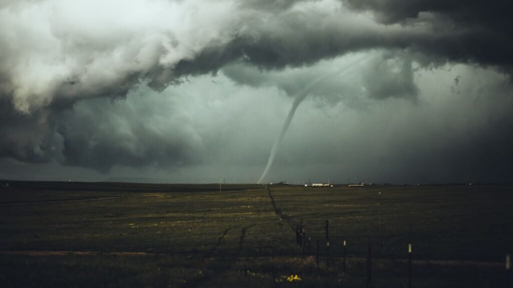
Core Hazards from Incoming Storms
The most prominent risk involves giant hailstones measuring 2 to 4 inches or larger, a size capable of shattering windshields and damaging property extensively.[1] These hail events often accompany supercell thunderstorms, which thrive in environments rich with moisture, instability, and wind shear. Tornadoes represent another major concern, with potential for EF2 or stronger twisters that bring winds over 110 mph and widespread destruction.
Damaging straight-line winds add to the peril, frequently topping 74 mph in downdrafts and contributing to structural failures or downed power lines. The combination of these elements heightens the overall severity, particularly where storms organize into persistent clusters. Recent atmospheric patterns, including a jet stream dip and low-pressure systems advancing from the Rockies, set the stage for this volatility.[2]
Saturday’s Peak Threat Window
A moderate risk, rated 4 out of 5 by the SPC, covers parts of central and eastern Oklahoma on Saturday, with an enhanced threat stretching from Kansas into north Louisiana.[2] In Texas, north and central regions face elevated dangers as activity fires in the afternoon and peaks during evening hours. Cities such as Dallas sit in the path where supercells could produce the largest hail and isolated strong tornadoes, possibly reaching EF3 intensity.[1]
A dryline pushing into central and western Texas will serve as a focal point for storm initiation, drawing in Gulf moisture to boost thunderstorm vigor. Over 20 million people across seven states encounter this initial wave, underscoring the scale of preparation needed. Local flooding from heavy downpours emerges as a secondary issue in vulnerable spots.
- Giant hail: 2-4+ inches possible, especially in supercells.
- Tornadoes: EF2+ likely, EF3 potential in high-risk zones.
- Winds: Gusts over 74 mph, damaging to infrastructure.
- Areas: North Texas, Oklahoma, Kansas at forefront Saturday.
Sunday Shifts and Lingering Dangers
The action relocates northward Sunday, with another moderate risk spanning central Kansas to western Missouri. An enhanced outline blankets southern Nebraska through northern Texas, where scattered supercells along the dryline threaten very large hail and damaging gusts.[2] South Texas enters the picture late, as isolated storms along the dryline carry a conditional chance for strong tornadoes if they sustain.
Cities like San Antonio, Austin, and Oklahoma City remain vigilant, facing primarily hail and wind hazards even as tornado odds dip slightly. The overall event impacts up to 55 million across the South and Central U.S., amplifying the urgency for safety measures. Upper-level support from a deepening low-pressure trough sustains the hostile setup into early next week.
Context from Recent Outbreaks
This weekend’s forecast echoes patterns from earlier in April, when an EF4 tornado ravaged areas near Enid, Oklahoma, on Thursday with winds of 170-175 mph. That storm marked the first EF4 in Garfield County since 1991 and injured 10 people, prompting a rare tornado emergency.[1] Over 20 tornadoes touched down Thursday from Oklahoma to Iowa, alongside 160 wind and hail reports.
Friday added more damage with one tornado in Kiowa, Oklahoma, and over 75 severe reports. Last week’s tally reached 96 tornadoes and 1,300 severe events nationwide. Residents in the Plains draw on these experiences to prioritize shelter plans and monitor updates closely.
As storms approach, emergency managers stress heeding local warnings and securing outdoor items. The weekend holds significant potential for impactful weather, but timely action can mitigate the worst outcomes.