DFW Airport’s Historic Rainfall Milestone (Image Credits: Pexels)
Dallas – Powerful storms swept through North Texas on Wednesday, delivering torrential rains that broke long-standing records and caused significant structural damage along with urgent emergency responses.
DFW Airport’s Historic Rainfall Milestone
Dallas/Fort Worth International Airport logged 1.55 inches of rain, surpassing the previous daily record of 1.27 inches from 1937.[1][2]
This mark nearly 90 years old fell amid a broader deluge across the region. Areas east of Dallas, such as Mesquite and Seagoville, received 4 to 8 inches. Wills Point and parts of Van Zandt County reported even higher totals, approaching 8.3 inches in estimates. The sudden intensity caught many off guard, turning streets into rivers within hours.
Officials noted the rapid accumulation overwhelmed drainage systems long before the storms peaked.
Warehouse Roof Buckles Under Water Weight
In Garland, a commercial warehouse at the 2900 block of West Kingsley Road near Shiloh Road suffered a dramatic roof collapse around 5 p.m.[1][3]
Heavy rainfall caused water to pool on the structure, leading to the failure. Seven workers inside managed to evacuate without injury, according to fire department reports. Responders arrived quickly to secure the site, where twisted metal and debris marked the scene.
No one remained trapped, but the incident highlighted vulnerabilities in older commercial buildings during extreme weather. Cleanup efforts began immediately, though saturated ground complicated access.
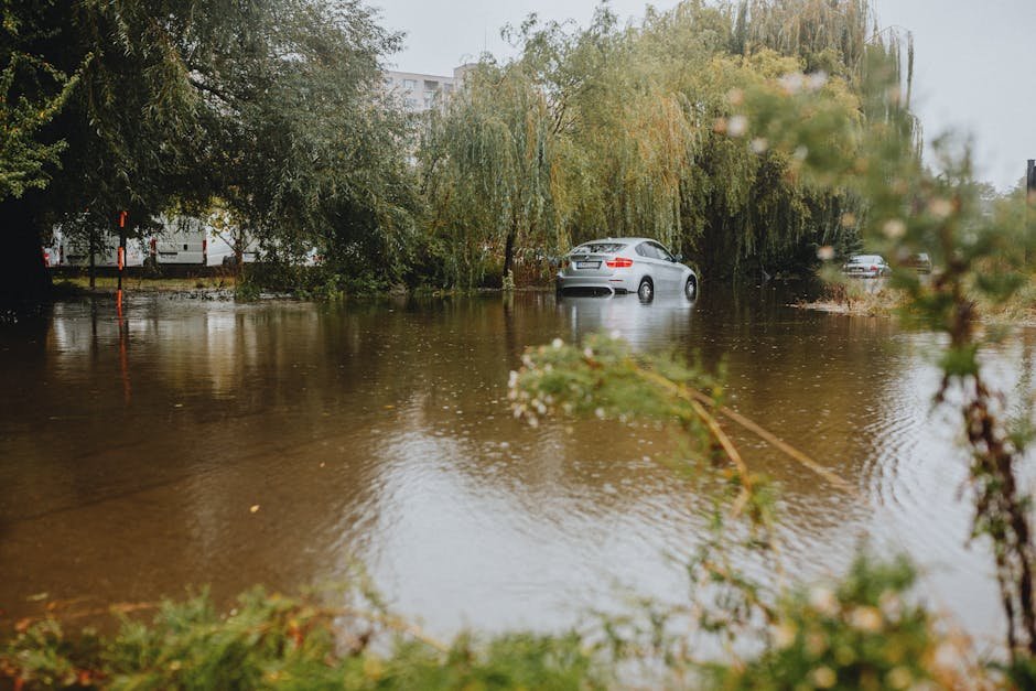
High-Water Rescues Surge Across Metroplex
First responders conducted numerous high-water rescues in Mesquite, Seagoville, and Wills Point as floodwaters trapped residents in vehicles and homes.[2]
On northbound Interstate 45 near East Palestine Street in Hutchins, severe flooding stalled multiple cars, resembling a river according to witnesses. Crews pulled drivers to safety amid rising levels. Homes in low-lying areas saw water invade quickly, forcing evacuations.
- Mesquite: Vehicles submerged on major roads.
- Seagoville: Residents rescued from attics and upper floors.
- Wills Point: Flash floods isolated neighborhoods.
- Hutchins: Highway turned impassable, stranding motorists.
Lightning and Fires Compound the Damage
A lightning strike ignited a two-story home in Fort Worth, reducing it to heavy fire damage Wednesday night. Flames burst through the roof shortly after the bolt hit.[1]
Spectacular “spider lightning” lit up Lake Ray Hubbard, adding to the night’s hazards. No injuries occurred in the blaze, but firefighters battled the inferno under rainy conditions. These events underscored the storms’ multifaceted threats beyond flooding alone.
| Location | Rainfall (inches) |
|---|---|
| DFW Airport | 1.55 (record) |
| Mesquite/Seagoville | 4-8 |
| Van Zandt County | ~8.3 |
Key Takeaways
- DFW’s 89-year rainfall record broken with 1.55 inches.
- Garland warehouse collapse: No injuries among 7 workers.
- Multiple rescues amid flash floods; more storms loom Friday.
Thursday brought relative calm with scattered showers, but forecasters warned of a stronger storm round Friday into Saturday, carrying risks of tornadoes, 2-inch hail, 75 mph winds, and further flooding on soaked soils. North Texas residents assessed damages while bracing for potential repeats. How did the storms affect your area? Share your experiences in the comments.