Imagine standing in the middle of a vast, featureless desert or staring up at an impenetrable rainforest canopy, and being told that beneath your feet lies the remnants of a thriving city that once housed tens of thousands of people. Sounds impossible, right? Yet this is precisely what is happening across the globe as scientists harness the power of satellite imaging technology to pull back the curtain on civilizations we never knew existed.
For centuries, the search for lost worlds relied on boots on the ground, shovels in the earth, and frankly, a fair amount of luck. Today, an orbiting satellite can do in hours what field teams could not accomplish in decades. What you are about to discover will fundamentally change the way you think about human history. Let’s dive in.
The Rise of Satellite Archaeology – A New Era for the Ancient World
Honestly, there is something almost poetic about using 21st-century technology to uncover civilizations that vanished thousands of years ago. For centuries, the search for lost civilizations was an endeavor of explorers hacking through jungles, desert wanderers following faint trails, and divers plunging into the depths of seas. The great discoveries of the past, from Machu Picchu nestled in the Andes to Troy buried beneath layers of earth, came at the cost of time, danger, and often sheer luck. That era has now given way to something far more extraordinary.
Satellite archaeology is not the work of Indiana Jones-style adventurers, but of scientists and engineers who harness the power of technology orbiting high above Earth. With satellites equipped with multispectral cameras, radar systems, and thermal sensors, researchers can uncover traces of human activity invisible to the naked eye. Ancient roads buried beneath forests, forgotten cities swallowed by shifting sands, and long-vanished trade networks leave subtle signatures in the landscape – signatures that satellites can capture.
As satellite imaging, including natural-color, false-color, and radar, evolved and became more accessible, a scientific community that had once measured the rise and fall of civilizations based on a few archaeological dig sites was suddenly turning up features hundreds or thousands of kilometers long. It is, to put it simply, one of the most exciting developments in the history of human knowledge.
How LiDAR Technology Sees Through Jungles and Into the Past
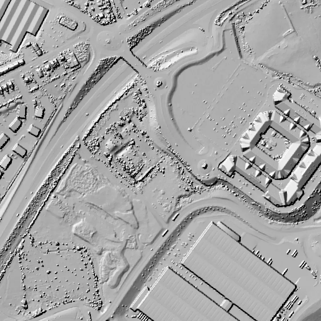
Some of the most dramatic discoveries in recent years have come via LiDAR, which stands for light detection and ranging. By airplane, helicopter, or drone, a LiDAR system aims rapid pulses of laser light at the surface and the reflections are processed to create a three-dimensional map. Advances in LiDAR have improved its ability to penetrate tree canopies and create precise images of the terrain below, revealing features that suggest past human activity.
Using laser-based scanning, this technology digitally peels back layers of vegetation to expose pyramids, sprawling road systems, and massive urban complexes that conventional archaeological methods would never have caught. The University of Cambridge reports that scientists identified more than 60,000 previously unknown structures in Guatemala’s Maya Biosphere Reserve alone. Think about that for a moment. Sixty thousand structures – not scattered stones, but actual buildings, hidden in plain sight beneath a forest canopy for centuries.
That has been revolutionary for scientists probing the rainforests of Central and South America, especially as LiDAR has become cheaper and easier to deploy. A decade or two ago you needed to charter a flight just to hold all the equipment. Now you can put the technology on a relatively cheap and lightweight drone. The democratization of this tool is accelerating discoveries at a pace nobody could have predicted.
The Maya Megalopolis – When Guatemala’s Jungle Gave Up Its Secrets
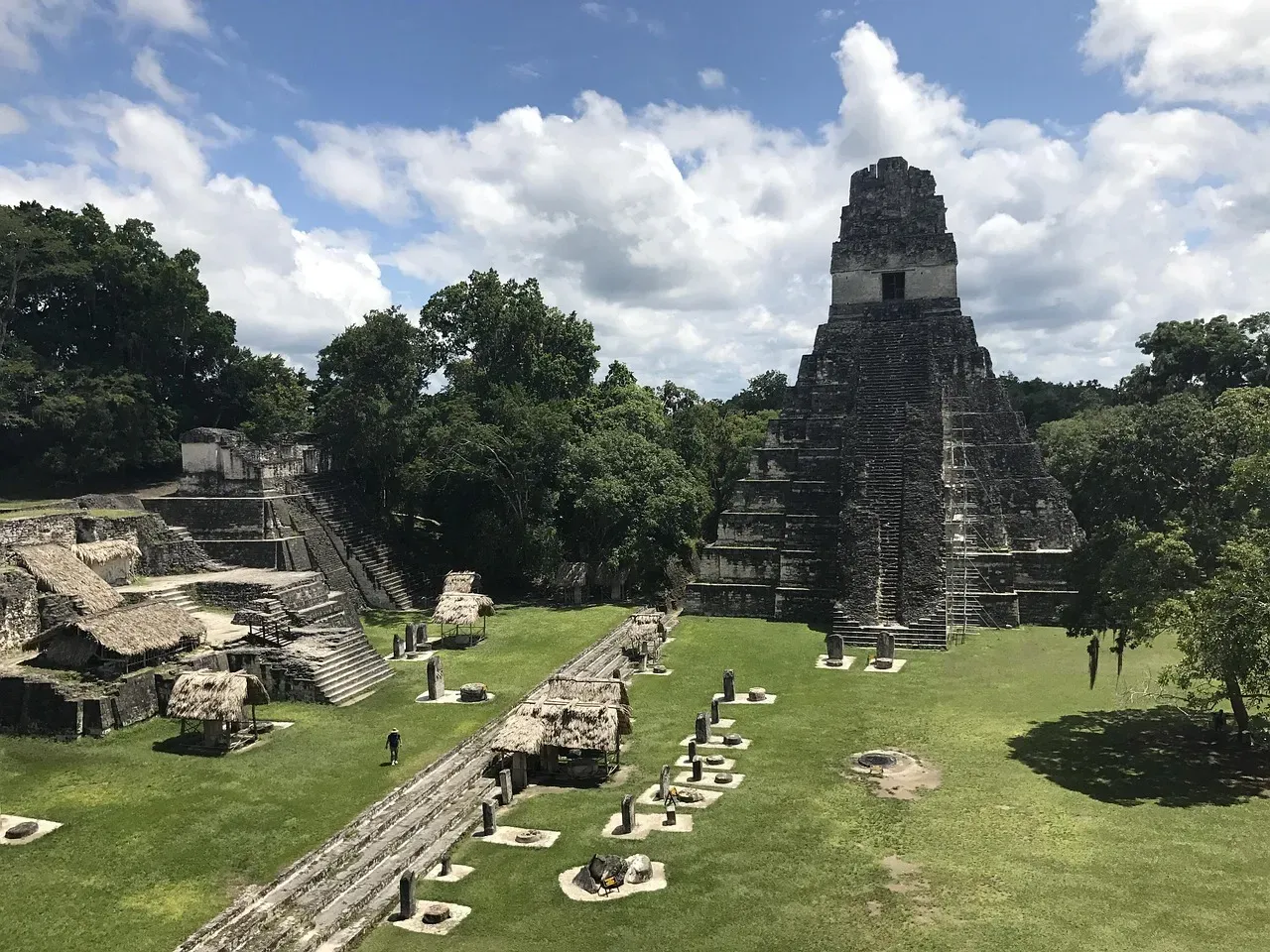
In what is being hailed as a major breakthrough in Maya archaeology, researchers have identified the ruins of more than 60,000 houses, palaces, elevated highways, and other human-made features that had been hidden for centuries under the jungles of northern Guatemala. Using LiDAR, scholars digitally removed the tree canopy from aerial images of the now-unpopulated landscape, revealing the ruins of a sprawling pre-Columbian civilization that was far more complex and interconnected than previously understood.
The results suggest that Central America supported an advanced civilization that was, at its peak some 1,200 years ago, more comparable to sophisticated cultures such as ancient Greece or China than to the scattered and sparsely populated city-states that ground-based research had long suggested. In addition to hundreds of previously unknown structures, the LiDAR images show raised highways connecting urban centers and quarries. Complex irrigation and terracing systems supported intensive agriculture capable of feeding masses of workers who dramatically reshaped the landscape.
Through the technology, researchers identified 110,000 buildings in the central Maya lowlands of southern Mexico and northern Guatemala, with roughly a third of those structures featuring masonry architecture designs such as vaulted ceilings and arches. Let’s be real – this is not merely an archaeological update. This is a complete rewriting of what we thought we knew about one of the most studied ancient cultures on earth.
The Sahara’s Hidden Cities – A Desert That Was Never Empty
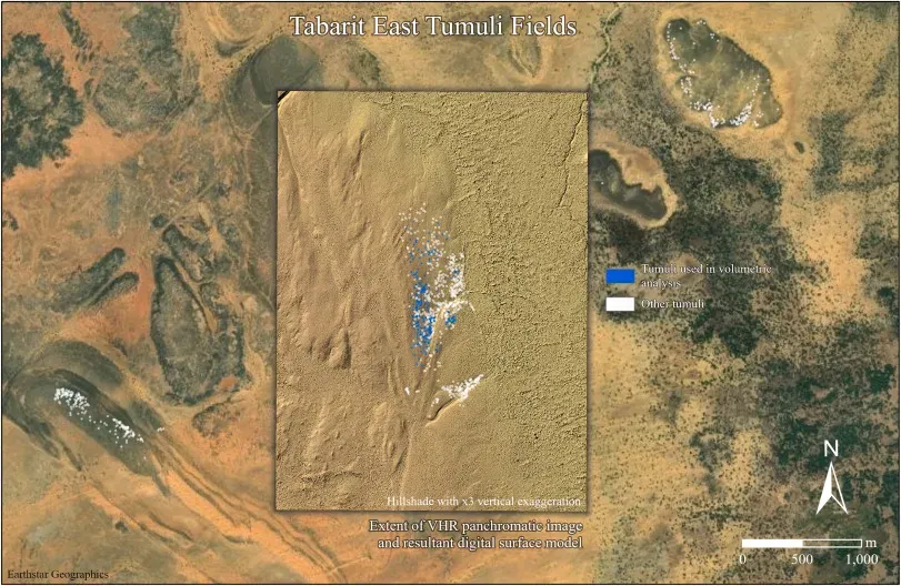
Satellite images have revealed traces of a vast ancient civilization in the Sahara desert. Until recently, archaeologists would have told you that the Sahara was an inhospitable environment devoid of large-scale human settlements. They were wrong. The desert, it turns out, holds secrets as remarkable as any jungle. You might never have guessed it looking at that endless sea of sand.
In one major project, a team led by Professor David Mattingly from the University of Leicester utilized high-resolution satellite imagery and aerial photographs to identify over 100 fortified settlements in the Fezzan region. The project capitalized on technological advancements to uncover sites previously obscured by the desert’s harsh terrain. The Garamantes were not the nomadic barbarians described by ancient Greek and Roman sources like Herodotus and Pliny. Instead, they developed a state with urban centers, a written language, metallurgy, and high-quality textile production.
Synthetic Aperture Radar has also uncovered ancient hydrological systems invisible to optical sensors in the Sahara Desert. Research in eastern Libya used SAR to map paleorivers and groundwater extraction systems associated with early settlements dating to the mid-Holocene humid period. The ability of SAR to detect subsurface moisture and subtle topographic features revealed extensive networks of channels and wells, demonstrating how ancient populations adapted to increasing aridity as the Sahara dried.
Sarah Parcak and the Space Archaeology of Ancient Egypt
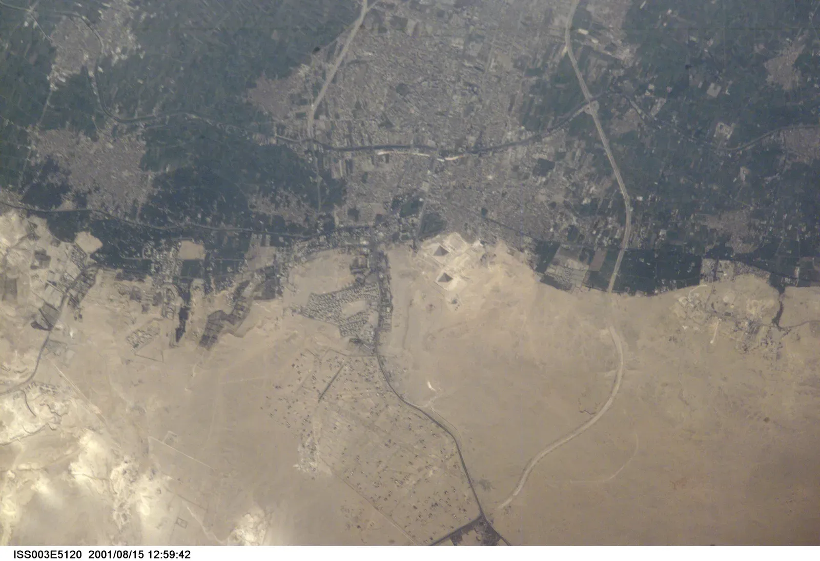
Exploiting subtle and, to the naked eye, often invisible differences in topography, geology, and plant life, Sarah Parcak, a professor of anthropology at the University of Alabama at Birmingham, has used satellite imagery and other remote sensing tools to expose a stunning array of forgotten sites from multiple lost cultures. She is, in the most literal sense, an archaeologist who works from space. I think that is one of the coolest job descriptions in the entire world of science.
In 2011, Parcak used satellite imagery to identify more than 3,000 potential ancient settlements, 1,000 tombs, and 17 pyramids hidden beneath the sands. These structures, invisible to ground-level surveys, emerged as faint rectangular outlines or shifts in soil composition detectable from orbit. Parcak’s work earned her the nickname “Space Archaeologist” and demonstrated that even the most explored regions still hold mysteries waiting in the shadows.
Parcak’s data predict that less than one percent of ancient Egypt has been discovered and excavated. According to Parcak, the technologies of the future, including GIS, remote sensing, and satellite imaging, are essential tools for mapping the past and saving ancient history before it is gone. Less than one percent. That number is staggering. Egypt, the most studied ancient civilization on earth, is still almost entirely a mystery.
AI Joins the Hunt – Machine Learning Meets Ancient History
Here is the thing that truly blew my mind when researching this topic. Scientists are no longer just looking at satellite images themselves – they are training artificial intelligence to do it for them, and the results have been extraordinary. A research team created a machine learning algorithm to analyze images collected by synthetic aperture radar, a satellite imagery technique that uses radio waves to detect objects hidden beneath surfaces including vegetation, sand, soil, and ice.
A Khalifa University research team reported that they found evidence of a civilization dating back 5,000 years beneath the sands of the Saruq Al-Hadid archaeological site located within the Rub al-Khali desert. Using SAR technology, or satellite-borne synthetic aperture radar, researchers used artificial intelligence in combination with satellite imagery to automate site detection and mapping. Dubai Culture, the government agency overseeing archaeological sites in the region, has already approved excavation for the area following the study’s publishing.
The “Cultural Landscapes Scanner” project, by the Istituto Italiano di Tecnologia and the European Space Agency, uses AI and satellite imagery to detect hidden archaeological sites. Over three years, the project applies machine learning to analyze satellite images, revealing subtle signs of ancient human activity that are hard for humans to see. This AI-driven approach aims to enhance the accuracy of site detection and aid in preserving cultural heritage by identifying threats like looting. It is as if the machines are becoming archaeologists themselves. A little unsettling, maybe. Mostly thrilling.
Protecting What We Find – The Race Against Time and Looting
Archaeologists are working on deadline, in a sense, because human activity can endanger ancient and prehistoric treasures. In Florida, for example, most of the prehistoric shell mounds created by indigenous people were destroyed as the state developed. Looting is also a major problem. Although satellite imagery is not likely to catch someone in the act of stealing a valuable artifact, it can find sites before they get looted.
In Syria, researchers have used freely available Landsat and commercial high-resolution images to document extensive looting at archaeological sites during the civil war. Thousands of small circular pits, visible in before-and-after satellite images, revealed illegal excavations across the region. Without satellite monitoring, these losses would have gone unnoticed in many dangerous or inaccessible zones.
Because LiDAR data can live forever on a hard drive, it is not only a window to the past but a tool for preservation. Climate change and urban sprawl will continue, but the information gathered by LiDAR represents a permanent digital record. If an earthquake were to wipe out Colombia’s Ciudad Perdida tomorrow, archaeologists would still have the data to analyze the ancient settlement, exactly as it was when first mapped. That is a form of immortality for these places. One we should all feel grateful exists.
Conclusion
What we are witnessing right now is nothing short of a golden age of archaeological discovery. You are witnessing a golden age of archaeological discovery that is literally rewriting ancient history. LiDAR archaeology has demonstrated that civilizations we assumed we understood were actually far more extensive and sophisticated than anyone imagined possible. The sheer scale of what remains hidden is almost humbling.
The field is still young, and its future holds astonishing possibilities. Advances in artificial intelligence will allow machines to scan satellite data automatically, detecting archaeological features with ever-increasing accuracy. Higher-resolution satellites, hyperspectral imaging, and integration with drone-based surveys will push the boundaries of discovery even further. We may soon map entire civilizations that have been erased from history books, reconstruct ancient trade routes across continents, and uncover sites that redefine our understanding of human evolution.
Think about how much of human history is still out there, waiting patiently beneath a canopy of trees, beneath desert sand, or beneath the shallow waters of an ancient coastline. The technology to find it now exists. The will to protect it must match the power to discover it. So here is a question worth sitting with: if an entire civilization of millions of people can stay hidden for a thousand years, what else might we have gotten completely wrong about our past?