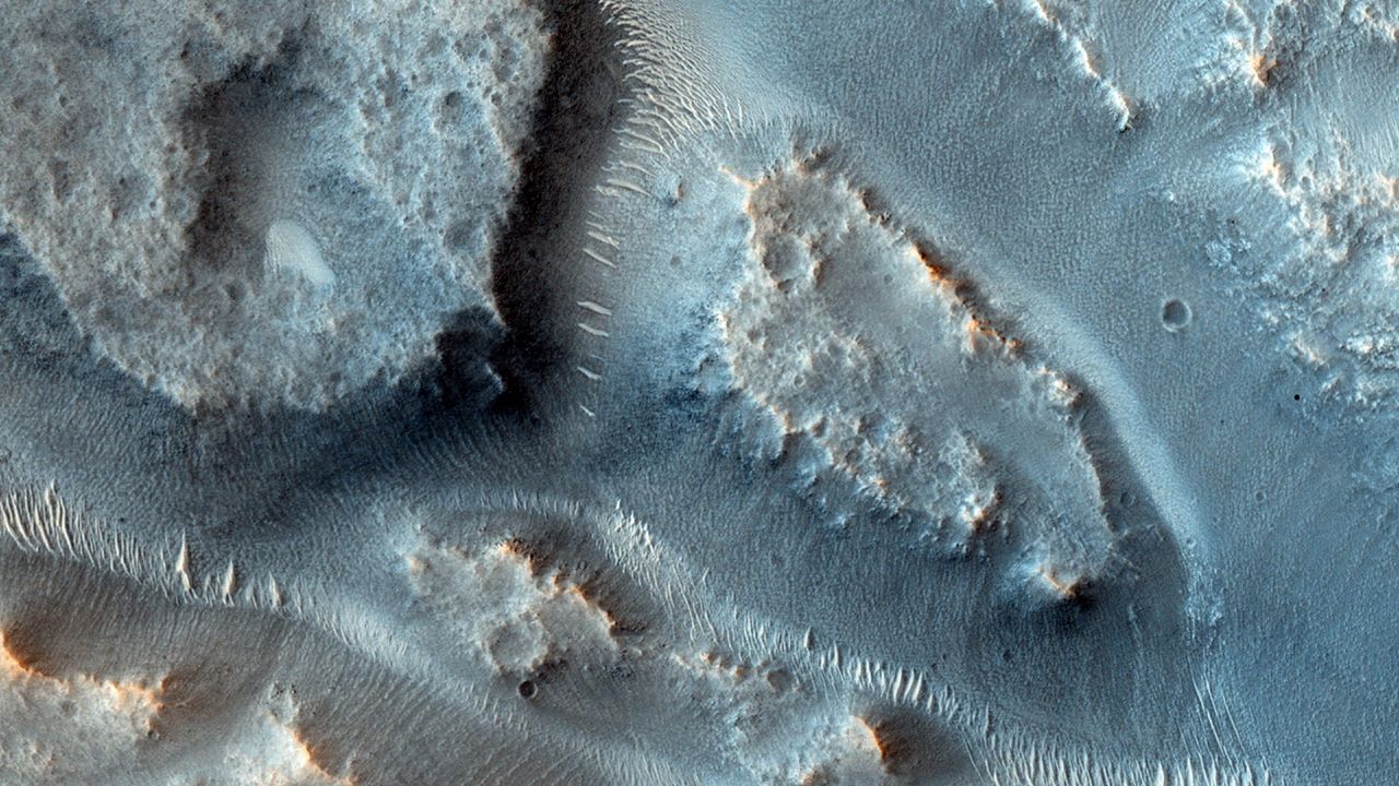
A Game-Changing Discovery in Martian Hydrology (Image Credits: Cdn.mos.cms.futurecdn.net)
Imagine vast networks of water carving through a rusty red landscape billions of years ago, leaving behind clues that could rewrite what we know about our cosmic neighbor.
A Game-Changing Discovery in Martian Hydrology
Researchers just unveiled the first comprehensive maps of Mars’ ancient river basins, and it’s like pulling back a curtain on a long-lost world. These weren’t just trickles; we’re talking massive systems that rival Earth’s biggest waterways. For the first time, scientists can trace how water once flowed across the planet, shaping its surface in ways that scream habitability.
The team behind this, from the University of Texas at Austin, pulled together data from satellites and ground observations to sketch out 16 major drainage basins. Though Mars lacks the tectonic drama that builds Earth’s grand canyons, these basins still managed to move huge amounts of sediment – nearly half of all the erosion from rivers back in the day. It’s a reminder that the Red Planet was once wet and wild, potentially teeming with the building blocks for life.
Why These Basins Matter for the Hunt for Life
Picture this: on Earth, the mightiest rivers like the Amazon or Ganges cradle diverse ecosystems and even sparked human civilizations. Mars’ versions did something similar, concentrating nutrients in sediments that could have nurtured microbial life. These spots, covering just 5% of the ancient terrain, handled 42% of the planet’s river-eroded material – about 28,000 cubic kilometers worth.
Water flowing through these systems interacted with rocks, dissolving minerals and creating chemical soups perfect for biology. If life ever took hold on Mars, these basins would be the prime real estate. The maps now guide rovers and future missions straight to the most promising digs, turning vague hopes into targeted searches.
How Scientists Pieced Together the Puzzle
Building these maps wasn’t a walk in the park. The researchers combined valley networks, ancient lake beds, and outlet canyons using tools like NASA’s Mars Reconnaissance Orbiter and software such as ArcGIS Pro. They applied Earth-style hydrology tricks to Martian geology, verifying everything with high-res satellite shots.
Unlike our dynamic planet, Mars froze over eons ago, preserving these features like fossils in stone. The result? A global atlas showing how rainfall once fed rivers that possibly drained into oceans. It’s meticulous work that bridges billions of years, making the abstract feel tangible.
Comparing Mars to Earth’s Watery Past
Mars’ basins echo Earth’s major watersheds but on a quieter scale. Take the Indus or Nile – those cradled early humans with fertile floods. Martian counterparts, though fewer due to no plate tectonics, still sculpted the landscape dramatically.
| Feature | Mars Basins | Earth Examples |
|---|---|---|
| Number of Major Systems | 16 | 91 |
| Surface Coverage | 5% of ancient terrain | Varies widely |
| Sediment Transport | 42% of total erosion | Supports global biodiversity |
This table highlights the scale: Mars punched above its weight with fewer but mightier flows. Such parallels help us grasp how water drives life, even across planets.
Implications for Future Mars Exploration
These maps aren’t just pretty pictures; they’re roadmaps for NASA’s next steps. Rovers like Perseverance could zero in on basin sediments for biosignatures – fossilized microbes or organic traces. With missions ramping up, this intel prioritizes sites that maximize the odds of finding something extraordinary.
Experts like Taylor Perron from MIT note how these systems linked water to nutrients, boosting habitability potential. As we eye human trips to Mars, understanding its watery history could inform where to land and what to protect. It’s exciting to think how this might accelerate the search for extraterrestrial neighbors.
Challenges and What Lies Ahead
Mapping ancient Mars comes with hurdles, like distinguishing wind erosion from water scars. Yet, the evidence stacks up: layered sediments and channel patterns point to sustained flows, not fleeting events. Ongoing analysis will refine these maps, perhaps uncovering even more basins.
Looking forward, international teams plan to integrate data from upcoming orbiters. This could reveal seasonal patterns or even subsurface water hints. The big question remains: did life hitch a ride on these ancient currents?
Key Takeaways:
- Mars’ 16 major basins moved massive sediments, ideal for preserving life signs.
- They cover little ground but drove most river erosion, like Earth’s vital waterways.
- New maps target future missions, boosting chances of discovering ancient habitability.
In the end, these river maps remind us that Mars’ story is far from over – it’s a tale of lost oceans and possible origins that could mirror our own. What spots on the Red Planet intrigue you most for the life hunt? Share your thoughts in the comments.

Jan loves Wildlife and Animals and is one of the founders of Animals Around The Globe. He holds an MSc in Finance & Economics and is a passionate PADI Open Water Diver. His favorite animals are Mountain Gorillas, Tigers, and Great White Sharks. He lived in South Africa, Germany, the USA, Ireland, Italy, China, and Australia. Before AATG, Jan worked for Google, Axel Springer, BMW and others.