In a year when satellites and sonar peeled back more blue on our maps than ever before, one revelation stole the breath of even seasoned geologists: the tallest mountain on Earth spends most of its life underwater. Recent advances in seafloor mapping have provided clearer views of a colossal volcano whose hidden base rises higher from seafloor to summit than Everest does from sea level to sky. The shock isn’t that this giant exists – it’s that modern tools finally let us see the full shape with clarity. It’s a reminder that Earth’s greatest peaks don’t have to touch the clouds to break records, and that our oceans still keep game‑changing secrets within arm’s reach of the shore.
The Hidden Clues
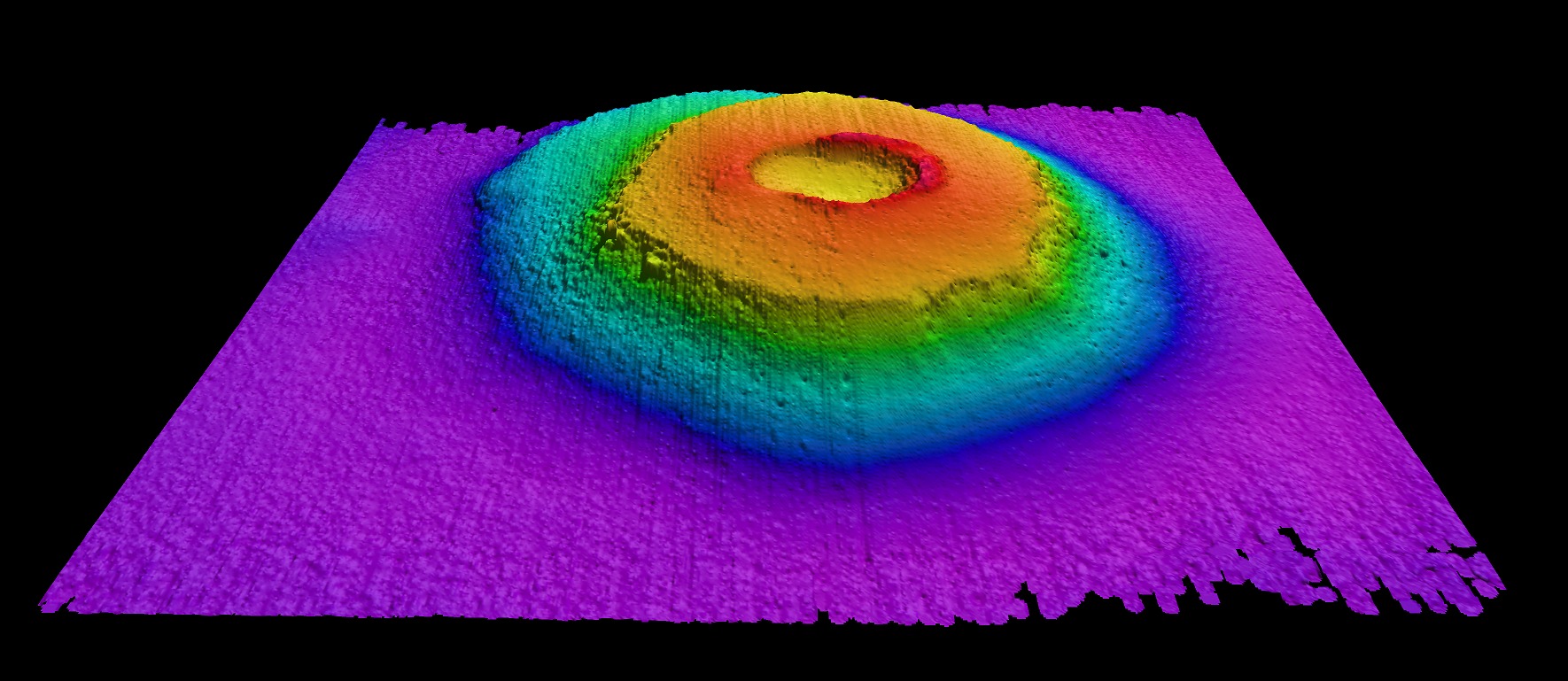
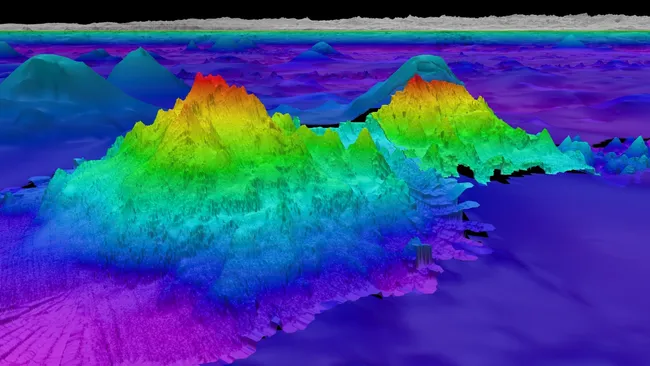
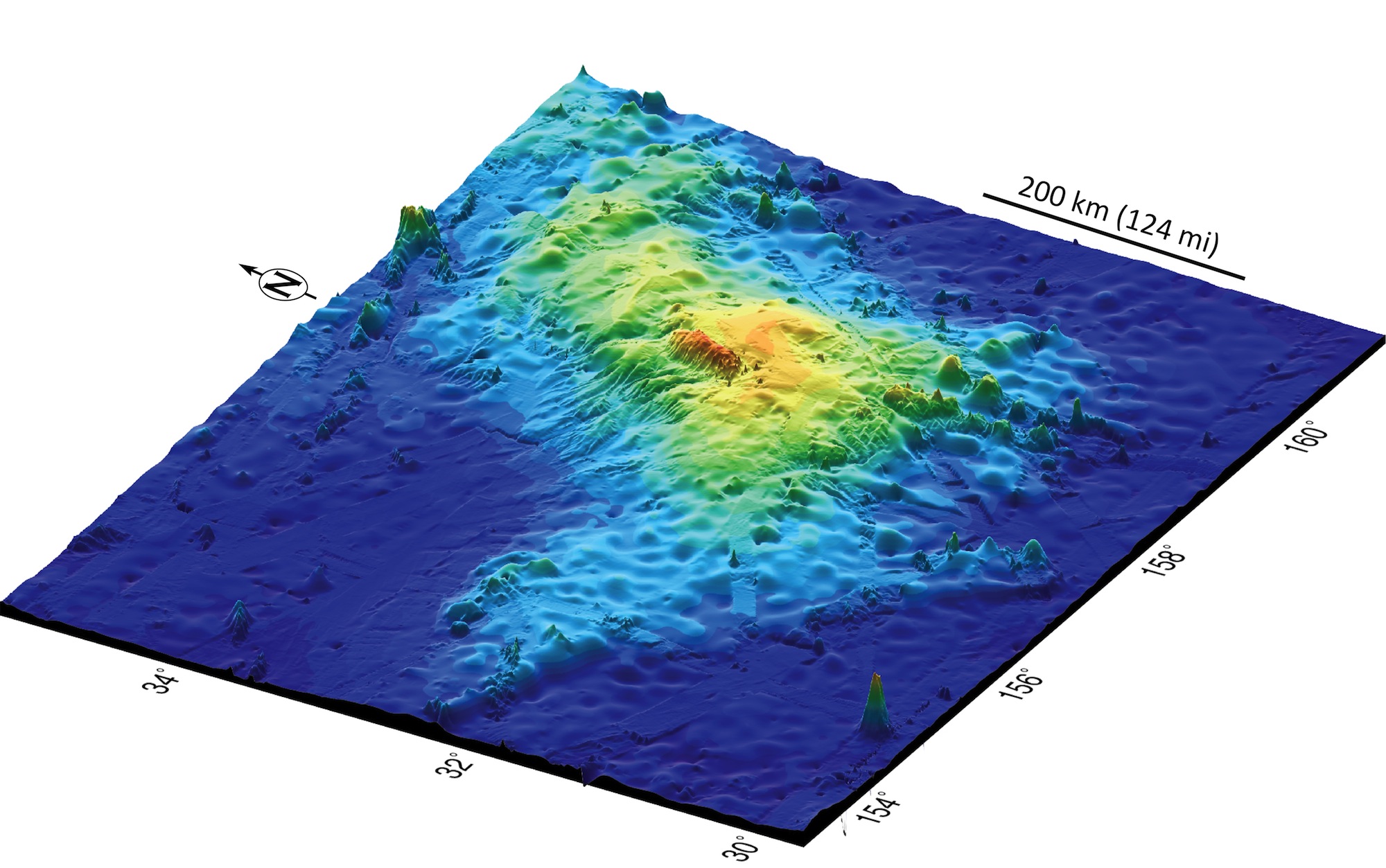
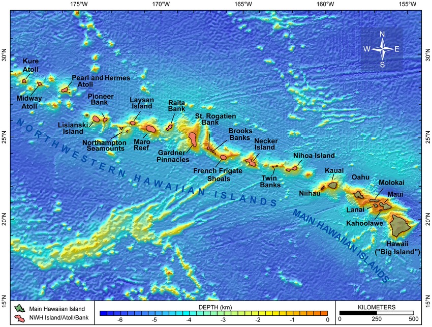
Here’s the twist: the tallest mountain on the planet isn’t the one you picture on postcards. When measured from base to peak, a volcano rooted on the Pacific seafloor climbs more than Everest – yet roughly all of that height is drowned beneath waves. Satellite gravity readings and multibeam sonar have provided increasingly detailed views, sharpening a fuzzy silhouette into a crisp profile. Those measurements capture subtle bulges in sea-surface height and echo-sound pulses bouncing off rock thousands of meters below.
To a mapper, these are not trivia; they’re breadcrumbs leading to submerged giants. Where older charts smoothed over broad features, the latest bathymetry resolves steep ridges, collapsed calderas, and razor-backed spurs. The result feels like swapping a watercolor for a high-definition photograph. Suddenly, a peak we thought we knew has a fuller story – and a taller one.
From Ancient Tools to Modern Science
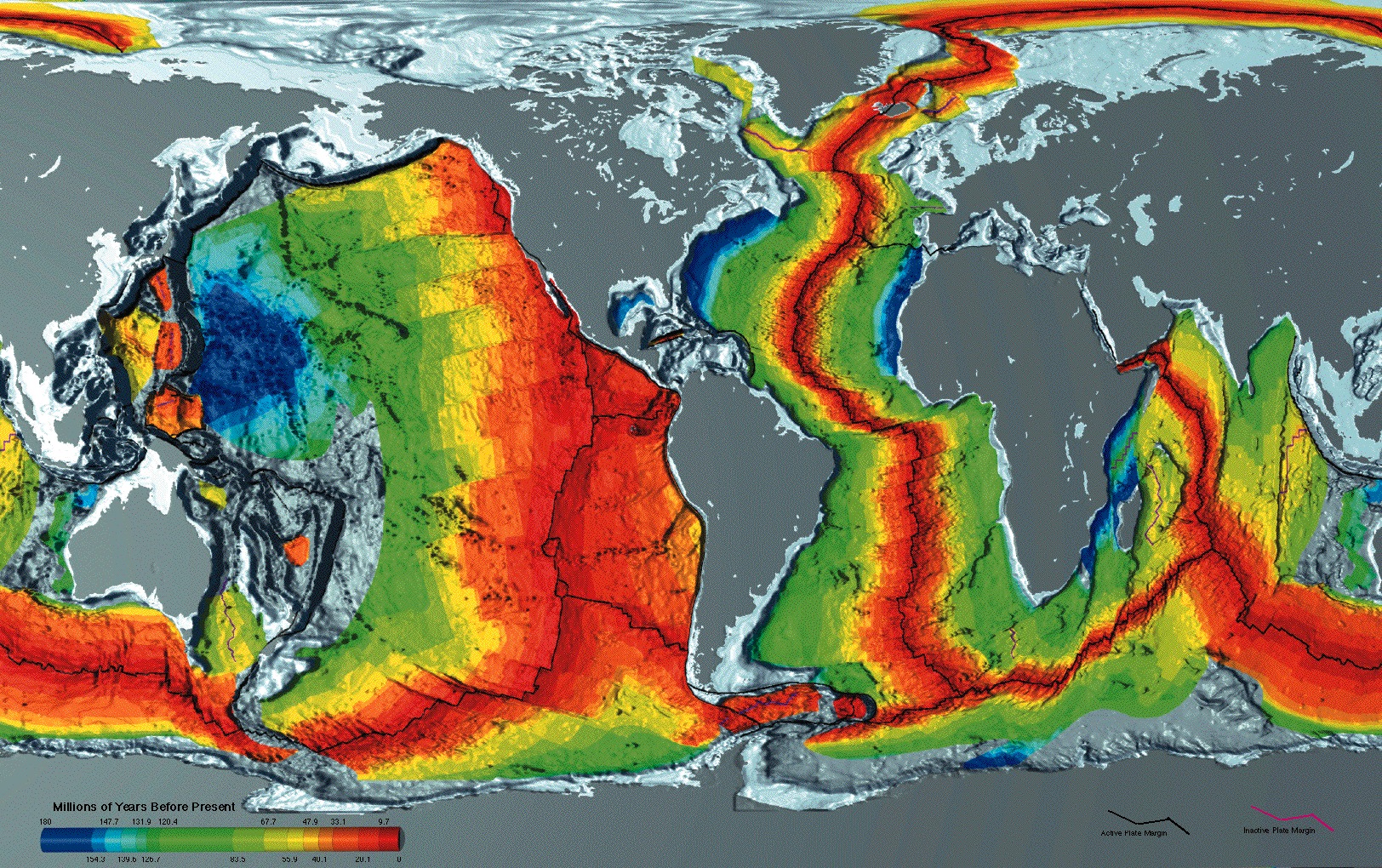
Mariners once dragged lead lines to guess the ocean’s depth, sketching coastlines while the abyss remained anonymous. Echo sounding in the twentieth century replaced guesswork with sound, but only along narrow ship tracks that left vast gaps. Recent data advances fuse shipboard multibeam surveys with satellite altimetry that senses gravity’s tug on the sea surface, filling in the blanks between expeditions.
Layer in machine learning that flags likely seamounts in raw grids, and the ocean floor blooms with detail. What used to take decades of ship time now happens in months, and each pass finds new ridges, terraces, and buried roots that reset the world’s leaderboard of relief.
What We Mean by Taller
Height is a trickster. Everest is the highest mountain above sea level, rising to about eight thousand eight hundred and fifty meters, which is why it reigns in mountaineering lore. But if you measure mountains from their true base to their true summit, the Pacific volcano takes the crown with a total rise well past ten thousand meters. It’s like comparing skyscrapers from the lobby versus from the bedrock – change the measuring stick, change the champion.
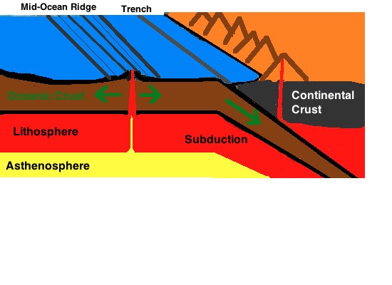
This isn’t a semantic game; it’s a geologic one. Oceanic crust sits far below sea level, so volcanic edifices there grow colossal foundations before they even sniff the air. The newest maps quantify that full pedestal more precisely, pushing the underwater giant beyond Everest by a dramatic margin and ending a debate that hinged on fuzzy bathymetry.
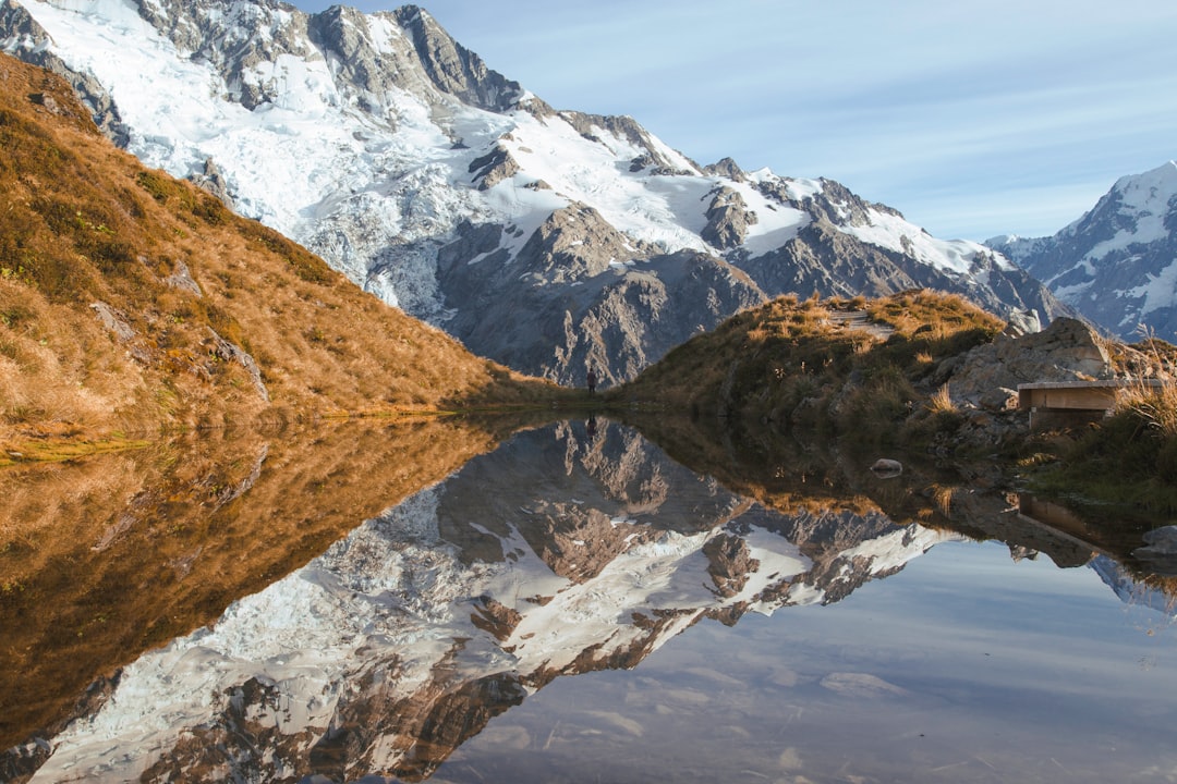
A Mountain Without a Summit Sky
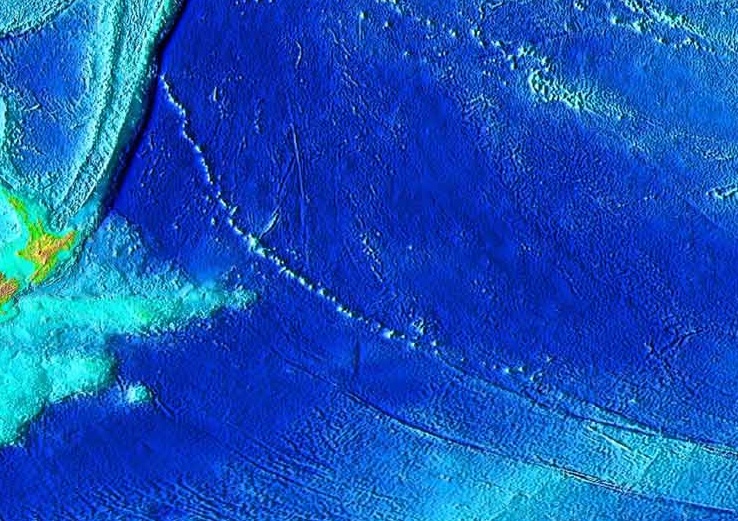
Picture a shield volcano broad as a small country, its base anchored on basaltic plains and its flanks layered by countless fluid lava flows. Most of its mass is hidden beneath the Pacific, with only its upper reaches breaking the surface as familiar high ground. The mountain’s story is a conveyor belt: a molten hotspot wells up from deep within Earth while a tectonic plate drifts overhead, building a chain of peaks that age and sink as they move away.
Viewed in profile with modern high-resolution, terraces step down the flanks like giant stairs, evidence of lava benches, landslides, and ancient shorelines from lower sea stands. The volcano’s underwater shoulders aren’t gentle; they’re riven with canyons carved by gravity-driven debris flows that once thundered into the abyss. Together, those details turn a mythic statistic into a tangible landscape you can trace on a map.
I remember staring at a sonar swath on a ship’s night watch years ago and feeling the same vertigo you get at a cliff edge. The ocean was no longer empty; it was architecture.
Why It Matters
Seeing the full height isn’t just a trivia win – it recalibrates our understanding of how planets build mountains and how oceans sculpt them. Seamounts act as baffles for deep currents, creating eddies that pump nutrients upward and seed life; higher relief means stronger effects. These giants are also archives: lava layers record magnetic flips of the planet, while sediments draped across ledges log past climates like rings in a tree. Without accurate shape, those readings are skewed.
There’s also a safety angle. Submarine landslides can generate damaging waves, and tall, over-steepened flanks are prime candidates. Better maps feed better hazard models, just as topographic detail on land sharpened flood and landslide forecasts. Compared with older, coarse grids, modern bathymetry slashes uncertainty and turns speculation into testable science.
Global Perspectives
The headline-grabbing peak is the symbol, not the exception. Oceanographers now suspect there are tens of thousands of sizable seamounts rising a kilometer or more, many unmapped and unnamed. Each is its own ecological island, hosting corals, sponges, and fishes that gather in swirling, nutrient-rich updrafts. On expeditions along Pacific ridges, researchers have routinely encountered creatures new to science perched on slopes that, until recently, didn’t even exist on charts.
Humans, of course, find these mountains too. Longlines and trawls have historically targeted seamounts because life concentrates there, while proposals for deep-sea mining eye nearby mineral-rich crusts. A clearer map is leverage for protection: you can’t safeguard what you can’t locate. Countries and consortia pressing for marine protected areas are now armed with coordinates precise enough to draw meaningful boundaries rather than vague boxes on blank space.
The Future Landscape
What comes next feels audacious. Uncrewed vessels can now roam for months, laying down multibeam swaths while satellites refine gravity maps overhead, and swarms of autonomous robots sample water, rock, and biology along the way. The push to map the entire seafloor by 2030 is more than a moonshot slogan; it’s a pipeline of new physics, new geology, and better stewardship.
Challenges remain. Weather, cost, and data-sharing bottlenecks still slow global coverage, and sensitive habitats need protection from the very attention mapping attracts. Yet the trajectory is clear: as resolution climbs, so does our capacity to forecast hazards, plan conservation, and trace Earth’s tectonic heartbeat. The is a curtain-raiser for an ocean that’s finally coming into focus.
The Hidden Costs and Hard Questions
Big discoveries force big reckonings. More detailed maps can supercharge industrial ambitions, from fisheries to mineral extraction, and history shows that exploitation often outruns governance. Tall seamounts are tempting targets because they concentrate life and resources, and that very concentration makes them fragile. The paradox is sharp: the better we know these places, the more responsibility we bear to act with restraint.
There’s another question simmering beneath the science: how do we value a mountain almost no one will ever see? The answer can’t just be economic. It has to include wonder, the kind that reframes our planet and our place on it. If a peak can be the tallest on Earth and still hide underwater, what else are we overlooking?
Conclusion
You don’t need a research vessel to help. Support organizations advancing open ocean mapping and deep-sea conservation, and when public comment periods arise for new marine protected areas, add your voice. Encourage your local aquarium, museum, or school to use up-to-date seafloor maps so the next generation sees the ocean as landscape, not blankness. If you love gadgets, contribute computing time to projects that process mapping data – some run on volunteer networks.
Most of all, be the person who brings this conversation to the dinner table and the classroom. Share the simple, staggering fact that the tallest mountain on Earth is largely underwater, and that better maps are changing what we know and how we care. The ocean is not an empty blue; it’s a world of mountains. Who’s ready to see them?

Suhail Ahmed is a passionate digital professional and nature enthusiast with over 8 years of experience in content strategy, SEO, web development, and digital operations. Alongside his freelance journey, Suhail actively contributes to nature and wildlife platforms like Discover Wildlife, where he channels his curiosity for the planet into engaging, educational storytelling.
With a strong background in managing digital ecosystems — from ecommerce stores and WordPress websites to social media and automation — Suhail merges technical precision with creative insight. His content reflects a rare balance: SEO-friendly yet deeply human, data-informed yet emotionally resonant.
Driven by a love for discovery and storytelling, Suhail believes in using digital platforms to amplify causes that matter — especially those protecting Earth’s biodiversity and inspiring sustainable living. Whether he’s managing online projects or crafting wildlife content, his goal remains the same: to inform, inspire, and leave a positive digital footprint.