
Picture this: you’re standing by a peaceful mountain lake, watching the gentle ripples catch the morning sunlight. The scene is so tranquil it almost feels like time has stopped. Now imagine that same serene body of water suddenly erupting like a massive underwater volcano, shooting deadly gas clouds into the air and claiming thousands of lives in minutes. This isn’t science fiction or some Hollywood disaster movie — it’s a terrifying reality that has happened before and could happen again. Deep beneath the surface of certain lakes around the world lies a hidden threat so dangerous that scientists dedicate their careers to monitoring it. These aren’t your typical neighborhood ponds we’re talking about, but geological time bombs that have already shown us their devastating power.
The Science Behind Limnic Eruptions
A limnic eruption occurs when dissolved gases, primarily carbon dioxide, suddenly escape from deep lake water in a massive, deadly release. Think of it like opening a shaken soda bottle, but instead of a small fizz, imagine a catastrophic explosion of gas that can suffocate everything in its path. The process begins when CO2 accumulates in the deeper layers of a lake, often from volcanic activity beneath the water or from decomposing organic matter. Under normal circumstances, this gas remains dissolved due to the immense pressure at depth, similar to how carbonation stays in a sealed beverage. However, when something disturbs this delicate balance — whether it’s a landslide, earthquake, or even a change in temperature — the gas can suddenly break free from solution.
Lake Nyos: The Deadliest Example in History
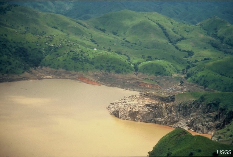
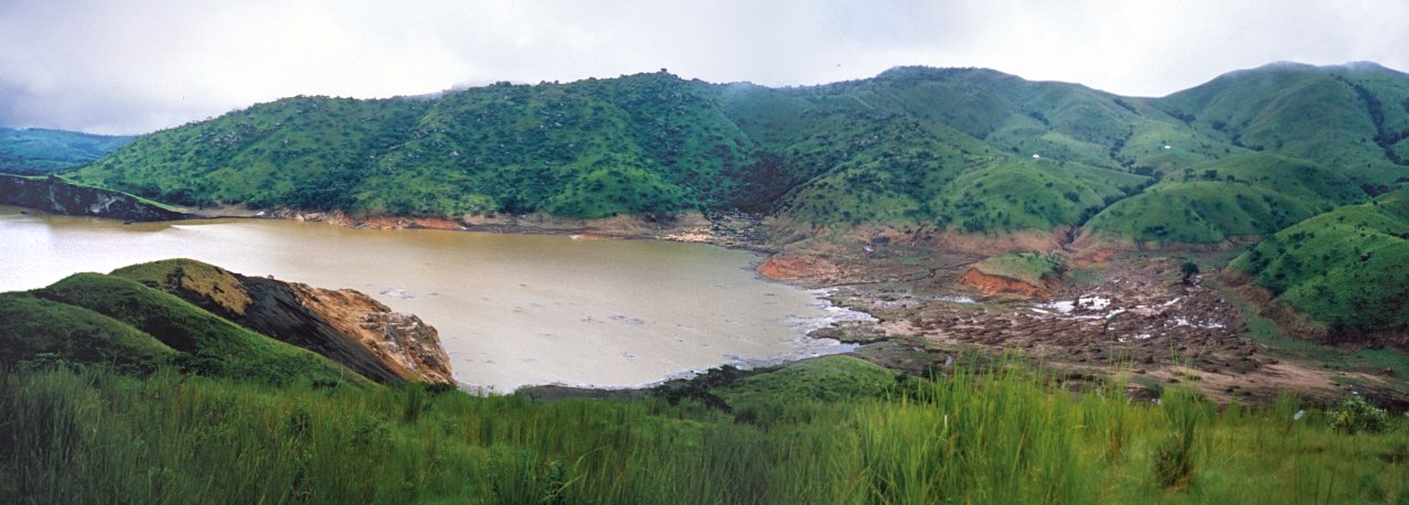
On August 21, 1986, Lake Nyos in Cameroon became the site of one of the most devastating natural disasters in African history. Without warning, the lake released approximately 1.6 million tons of carbon dioxide into the atmosphere in a matter of hours. The invisible cloud of death rolled down the valleys surrounding the lake, suffocating over 1,700 people and thousands of livestock within a 25-kilometer radius. Survivors described waking up to find their families dead beside them, with no obvious cause or warning signs. The tragedy at Lake Nyos opened the world’s eyes to a phenomenon that most people had never heard of before. This event became the catalyst for international research into limnic eruptions and sparked urgent efforts to prevent similar disasters.
Lake Monoun: The Warning That Went Unheeded
Two years before the Lake Nyos disaster, Lake Monoun, also in Cameroon, experienced a smaller but equally deadly limnic eruption. On August 15, 1984, this crater lake suddenly released a cloud of carbon dioxide that killed 37 people in the surrounding area. At the time, scientists and local authorities didn’t fully understand what had happened, attributing the deaths to various theories including chemical spills or mysterious diseases. The lack of immediate scientific investigation meant that valuable lessons weren’t learned from this earlier warning. When Lake Nyos erupted just two years later with far more devastating consequences, researchers realized they were dealing with a recurring natural phenomenon. The Lake Monoun incident now serves as a stark reminder of what can happen when we don’t pay attention to nature’s warning signs.
The Perfect Storm: Geological Conditions for Deadly Lakes
Not every lake can become a limnic bomb — specific geological conditions must align to create this deadly potential. These dangerous lakes are typically found in volcanic regions where carbon dioxide seeps up from underground sources, often through the lake bed itself. The lake must also be deep enough to create the necessary pressure differential that keeps gases dissolved at the bottom while allowing them to accumulate over time. Meromictic lakes, which have distinct layers that don’t mix, are particularly susceptible because the deeper waters remain isolated from surface exchange. The combination of volcanic activity, sufficient depth, and stratified water layers creates what scientists call a “perfect storm” for limnic eruptions. These conditions are relatively rare globally, which is why only a handful of lakes worldwide pose this specific threat.
The Role of Water Density and Temperature
Temperature and density differences play crucial roles in maintaining the deadly stratification that makes limnic eruptions possible. In these dangerous lakes, the bottom layers remain consistently cold and dense, while surface waters are warmer and lighter, preventing natural mixing that would normally release gases gradually. This thermal stratification acts like a lid on a pressure cooker, keeping dissolved gases trapped in the depths. During certain seasons or weather events, small changes in temperature can disrupt this delicate balance and trigger a catastrophic release. Scientists have discovered that even a temperature change of just a few degrees can be enough to destabilize the entire system. Understanding these temperature dynamics has become essential for predicting when a lake might be approaching a dangerous tipping point.
Carbon Dioxide: The Silent Killer
Carbon dioxide might seem harmless since we breathe it out every day, but in high concentrations, it becomes a deadly asphyxiant. During a limnic eruption, CO2 concentrations can reach levels 10 to 50 times higher than normal atmospheric levels, creating an invisible zone of death. The gas is heavier than air, so it flows like water down valleys and into low-lying areas where people and animals seek shelter. Victims of CO2 poisoning often have no warning — the gas is colorless and odorless, and death can occur within minutes of exposure. What makes this particularly terrifying is that unlike other natural disasters, there are no obvious warning signs like ground shaking or visible threats. The silent nature of carbon dioxide poisoning means that entire communities can be wiped out before anyone realizes what’s happening.
Modern Monitoring Technologies

Today’s scientists employ an impressive array of high-tech monitoring equipment to keep watch over potentially dangerous lakes. Sophisticated sensors are deployed at various depths to continuously measure dissolved gas concentrations, temperature, and water chemistry. Automated weather stations around these lakes monitor atmospheric conditions that could trigger instability, while seismic equipment detects even the smallest ground movements that might disturb the water. Satellite imagery and remote sensing technology allow researchers to observe changes in lake color, surface temperature, and even detect gas releases from space. Real-time data transmission means that scientists can monitor these lakes 24/7 from laboratories thousands of miles away. This technological arsenal has revolutionized our ability to predict and potentially prevent future limnic eruptions.
Gas Extraction Systems: Defusing the Bomb

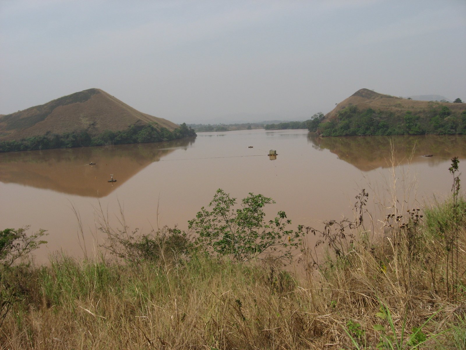
One of the most innovative solutions scientists have developed is the installation of degassing systems that slowly release trapped gases before they can build up to dangerous levels. These systems work like giant straws, using pipes that extend deep into the lake and rely on the natural pressure difference to bring gas-rich water to the surface. Once this deep water reaches the surface, the dissolved gases bubble out safely into the atmosphere in controlled amounts. Lake Nyos now has several of these degassing pipes installed, and they’ve successfully reduced the CO2 concentration in the lake’s deep waters by more than 60%. The beauty of this system is that it’s powered entirely by natural pressure differences, requiring no external energy source to operate. However, installing and maintaining these systems in remote locations presents significant engineering and logistical challenges.
Early Warning Systems and Community Preparedness

Developing effective early warning systems for limnic eruptions presents unique challenges because these events can happen with little to no advance notice. Scientists have worked with local communities to establish evacuation protocols and communication networks that can be activated if monitoring systems detect dangerous changes. Education programs teach residents to recognize potential warning signs, such as dead fish floating to the surface or unusual bubbling in the water. Emergency sirens and radio alert systems have been installed in high-risk areas, though the effectiveness of these systems depends heavily on community participation and understanding. Many communities near dangerous lakes now conduct regular evacuation drills, similar to earthquake or tsunami preparedness programs. The goal is to create a culture of awareness where everyone understands the risks and knows exactly what to do if an eruption occurs.
Lake Kivu: Africa’s Ticking Time Bomb
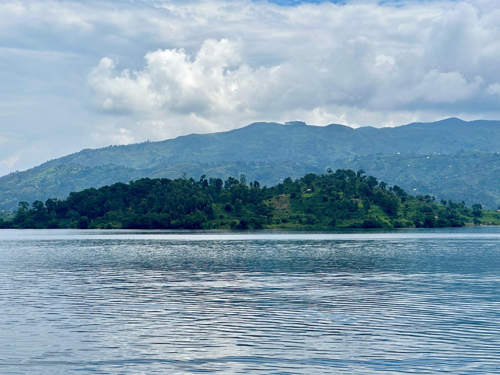
Lake Kivu, straddling the border between Rwanda and the Democratic Republic of Congo, represents perhaps the most dangerous limnic eruption threat in the world today. This massive lake contains an estimated 60 billion cubic meters of dissolved carbon dioxide and 55 billion cubic meters of methane — enough gas to make the Lake Nyos disaster look small by comparison. What makes Lake Kivu particularly terrifying is that over two million people live in its vicinity, making it a potential catastrophe of unprecedented scale. The lake sits in an active volcanic region, and recent seismic activity has raised concerns among scientists about stability. Unlike Lake Nyos, which affected a relatively small rural population, a limnic eruption at Lake Kivu could impact major cities and displace millions of people. International efforts are underway to develop comprehensive monitoring and mitigation strategies for this potential mega-disaster.
The Methane Factor: A Double-Edged Sword

While carbon dioxide gets most of the attention in discussions about limnic eruptions, methane presents its own unique dangers and opportunities. Lake Kivu’s massive methane reserves have attracted interest from energy companies who see the potential for harvesting this natural gas for power generation. Interestingly, extracting methane from the lake could help reduce the risk of a limnic eruption by disturbing the stratified layers and releasing gases gradually. However, the extraction process itself carries risks — if not done carefully, industrial activities could trigger the very disaster they’re trying to prevent. Several pilot projects are already operating on Lake Kivu, extracting methane for electricity generation while carefully monitoring the lake’s stability. This approach represents a potential win-win scenario where commercial interests align with public safety, though many scientists remain cautious about large-scale operations.
Volcanic Activity and Lake Destabilization

The relationship between volcanic activity and limnic eruptions adds another layer of complexity to monitoring efforts. Many dangerous lakes sit in active volcanic regions where underground magma chambers continuously feed CO2 into the water through springs and seepage. Volcanic earthquakes, even small ones, can disturb the delicate stratification that keeps gases dissolved in deep water. Scientists have observed that periods of increased volcanic activity often correlate with changes in lake gas concentrations and water chemistry. The challenge is distinguishing between normal volcanic fluctuations and potentially dangerous destabilization events. Advanced seismic monitoring networks now track not just major earthquakes, but tiny tremors that might indicate changes in the underground systems feeding these lakes.
Climate Change and Future Risks

Climate change introduces new variables into the already complex equation of limnic eruption risk assessment. Rising global temperatures could affect the thermal stratification that keeps dangerous lakes stable, potentially making eruptions more likely or changing their timing patterns. Changes in precipitation patterns could alter water levels and chemistry, while more frequent extreme weather events might provide the trigger mechanisms for gas releases. Some climate models suggest that certain regions with dangerous lakes could experience more frequent temperature fluctuations, increasing the likelihood of destabilization events. Scientists are now incorporating climate change projections into their long-term risk assessments for limnic eruption threats. The interaction between global climate patterns and local lake dynamics represents one of the newest frontiers in limnic eruption research.
International Cooperation and Research Networks

The study of limnic eruptions has become a truly international scientific effort, with researchers from dozens of countries sharing data, expertise, and resources. Organizations like the United Nations and World Bank have provided funding for monitoring systems in developing countries where many dangerous lakes are located. International conferences bring together geologists, volcanologists, atmospheric scientists, and emergency management experts to share the latest research findings. Cross-border cooperation is particularly important for lakes like Kivu that span multiple countries and require coordinated monitoring and emergency response plans. The global nature of this research effort has accelerated our understanding of limnic eruptions and improved our ability to predict and prevent future disasters. Scientific partnerships that began with studying individual lakes have evolved into comprehensive networks monitoring geological hazards worldwide.
Economic Impacts and Cost-Benefit Analysis

The economic implications of limnic eruption prevention extend far beyond the immediate costs of monitoring systems and gas extraction infrastructure. A major eruption at a lake like Kivu could cause billions of dollars in economic damage, not just from immediate casualties but from long-term displacement of populations and disruption of regional economies. The cost of prevention measures, while substantial, pales in comparison to the potential economic devastation of an uncontrolled eruption. Insurance companies and international development banks are beginning to factor limnic eruption risks into their assessments of projects in affected regions. Tourism, agriculture, and fishing industries around these lakes face ongoing uncertainty that affects investment and development decisions. The challenge for policymakers is balancing the upfront costs of prevention systems against the probability and potential magnitude of future disasters.
Lessons from Other Natural Disasters

The study of limnic eruptions has benefited enormously from lessons learned in monitoring and predicting other types of natural disasters. Earthquake early warning systems have provided models for rapid alert networks, while volcanic monitoring techniques have been adapted for tracking gas releases from lakes. The interdisciplinary approach that has proven successful in tsunami preparedness is now being applied to limnic eruption risk management. Hurricane tracking and prediction methodologies have influenced how scientists model the movement of gas clouds from erupting lakes. Perhaps most importantly, the community engagement strategies developed for other disasters have been crucial in building local awareness and preparedness around dangerous lakes. This cross-pollination of ideas and techniques has accelerated progress in limnic eruption science and improved our overall disaster preparedness capabilities.
The Human Element: Living with Invisible Danger

For the millions of people living near potentially dangerous lakes, the psychological burden of invisible threat can be overwhelming. Unlike volcanoes or fault lines, which provide visible reminders of geological danger, these lakes often appear completely benign on the surface. Communities must balance the practical needs of daily life — fishing, farming, access to fresh water — with the knowledge that disaster could strike without warning. Many residents develop a kind of resigned acceptance, similar to how people live near active volcanoes or in earthquake zones. Educational programs work to maintain awareness without creating unnecessary panic, a delicate balance that requires ongoing community engagement. The human stories from survivors of previous eruptions serve as powerful reminders of why continued vigilance and scientific monitoring remain so crucial.
Future Technologies and Innovations

The next generation of limnic eruption monitoring technology promises even more sophisticated early warning capabilities. Artificial intelligence and machine learning algorithms are being developed to analyze vast amounts of sensor data and identify subtle patterns that might precede dangerous gas releases. Underwater robots and autonomous vehicles could soon provide continuous monitoring capabilities without the need for human intervention in dangerous areas. Advances in satellite technology may enable real-time detection of gas releases from space, providing immediate global alerts for potential disasters. Nanotechnology sensors could offer more precise measurements of gas concentrations at the molecular level, while improved communication systems could ensure that warnings reach remote communities within seconds. These technological advances hold the promise of transforming limnic eruption monitoring from a reactive science to a truly predictive capability.
Global Implications and Planetary Science

The study of limnic eruptions on Earth has implications that extend far beyond our own planet, providing insights into atmospheric and geological processes that occur throughout the solar system. Scientists studying the methane lakes on Saturn’s moon Titan use knowledge gained from Earth’s dangerous lakes to understand similar processes in alien environments. The gas dynamics and pressure relationships observed in limnic eruptions help researchers model atmospheric evolution on Mars and other planets. Climate scientists studying ancient Earth use limnic eruption mechanisms to understand how massive gas releases might have influenced past climate changes. This planetary perspective adds another dimension to limnic eruption research, connecting local lake monitoring efforts to our broader understanding of how planetary systems work. The techniques developed for monitoring dangerous lakes on Earth may someday be adapted for studying potentially habitable worlds around other stars.
The invisible threat lurking beneath seemingly peaceful lakes represents one of nature’s most deceptive dangers. From the catastrophic eruption at Lake Nyos to the ongoing risks at Lake Kivu, these geological time bombs remind us that our planet still holds deadly surprises. Modern science has given us the tools to monitor, predict, and potentially prevent these disasters, but the challenge remains enormous. The combination of cutting-edge technology, international cooperation, and community preparedness offers hope that future tragedies can be avoided. Yet as climate change and human development continue to alter the delicate balance of these systems, vigilance becomes more critical than ever. The scientists working tirelessly to understand and monitor these dangerous lakes are literally standing between millions of people and potential disaster. Their work represents humanity at its best — using knowledge and technology to protect lives and prevent suffering. What would happen if we stopped watching these sleeping giants beneath the waves?