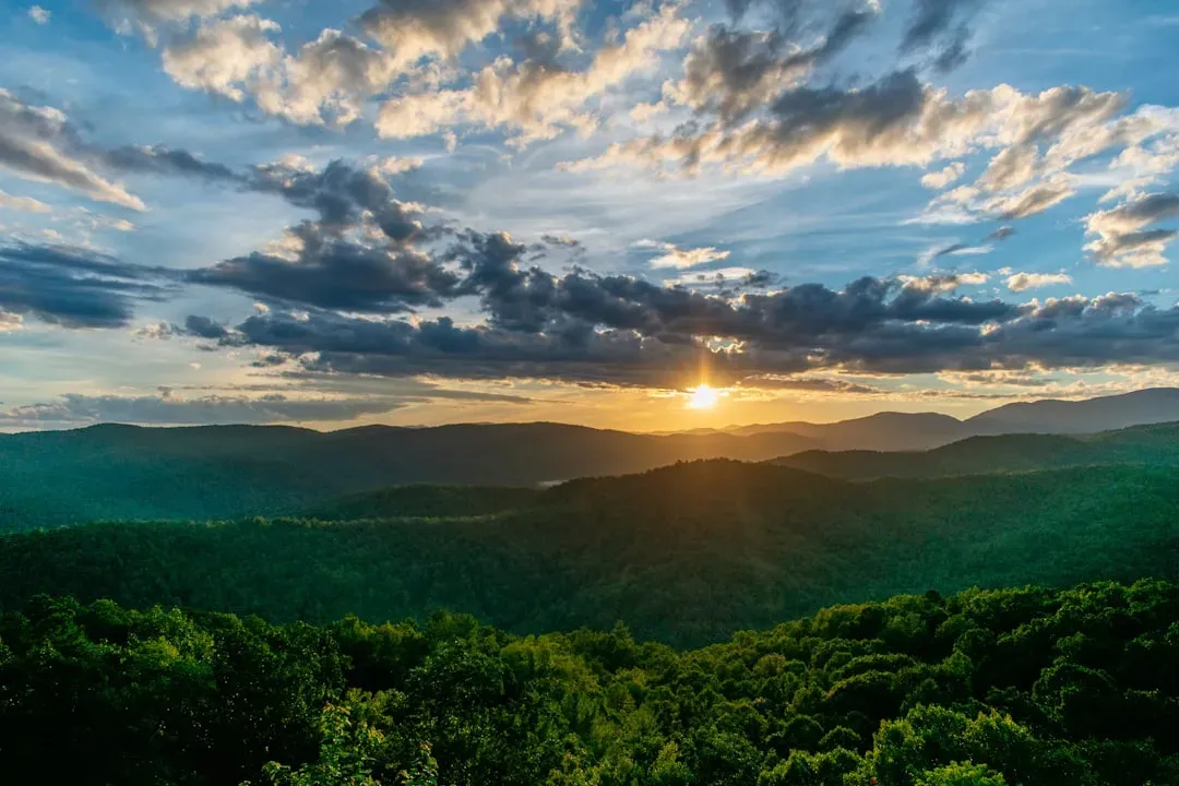
Stand at the edge of the Grand Canyon, look up at Yosemite’s granite walls, or drive across the flat heart of the Great Plains, and it’s hard not to feel small. These places look almost otherworldly, like some gigantic hand carved them overnight. But every cliff, every arch, every canyon is really a slow-motion crime scene, recording hundreds of millions of years of relentless geological forces at work.
Plate tectonics, volcanoes, rivers, ice, wind, and even ancient seas have all taken turns sculpting the United States into what we see today. Some forces ripped continents apart; others quietly polished rock grain by grain. Once you start to see the patterns, the landscapes that seem random and mysterious suddenly tell a story – one that’s far wilder than most of us were ever taught in school.
The Grand Canyon: A River That Carved Through Time
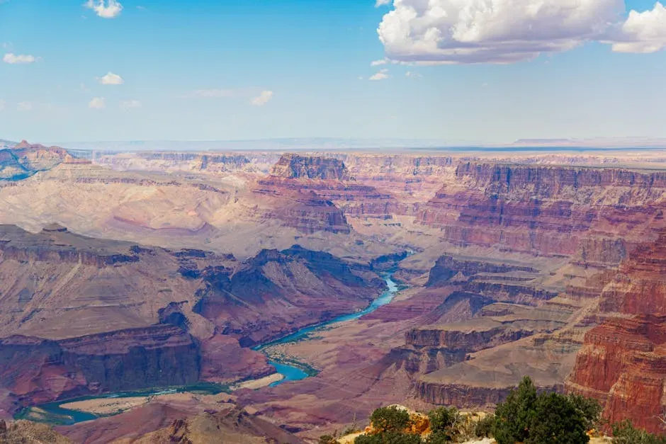
Imagine taking a knife and slicing through a layer cake roughly a mile thick – that’s essentially what the Colorado River has done in the Grand Canyon. For millions of years, the river has chewed downward through rock while the Colorado Plateau itself slowly rose, lifting the landscape even as the water cut deeper into it. That combination of uplift from deep within the Earth and relentless river erosion is why the canyon is both so deep and so dramatically exposed.
The rock layers here preserve a mind-bending timeline that reaches back nearly two billion years, from ancient seafloors to desert dunes turned to stone. You can literally walk down a trail and step millions of years into the past with every switchback. Wind, rain, and landslides have widened the canyon walls, carving side canyons, spires, and buttes that look like forgotten temples. It’s not just a big gash in the ground; it’s a living laboratory showing how water and uplift reshaped an entire region grain by grain.
Yosemite Valley: Granite Sculpted by Ice
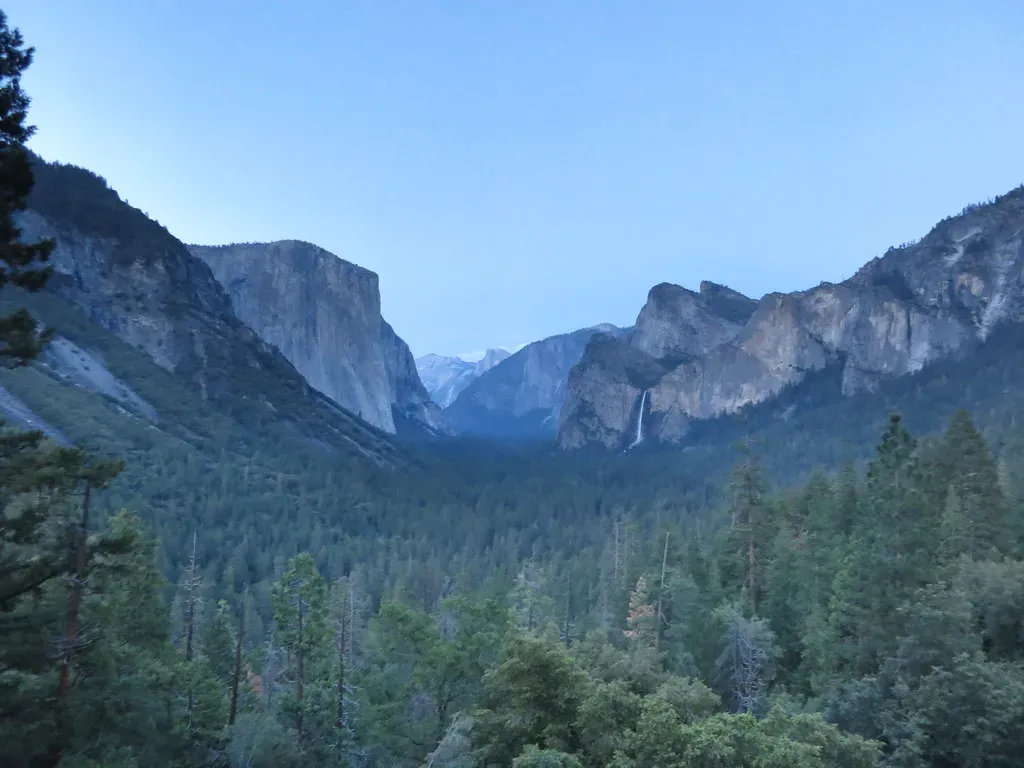
Yosemite’s vertical rock faces feel almost impossible, like someone cut a giant stone block with an invisible saw. The truth is more brutal and more beautiful: enormous rivers of ice once filled this valley. Before the glaciers arrived, the Merced River had already carved a V‑shaped valley into fractured granite. When the climate cooled, glaciers poured down these pre‑existing valleys, grinding and plucking rock as they went, transforming them into the broad U‑shaped profile we see today.
That smooth, shining granite isn’t actually smooth at all when you look closely; it’s covered with scars from the ice that once scraped across it. The towering walls of El Capitan and Half Dome are massive slabs of intrusive igneous rock, formed miles underground as molten magma slowly cooled and crystallized. Over tens of millions of years, overlying rock was stripped away, exposing this hard granite core. Then the glaciers arrived and polished it into the sheer, unmistakable shapes that make Yosemite feel like a stone cathedral.
Rocky Mountains: When Continents Collided and Crumpled
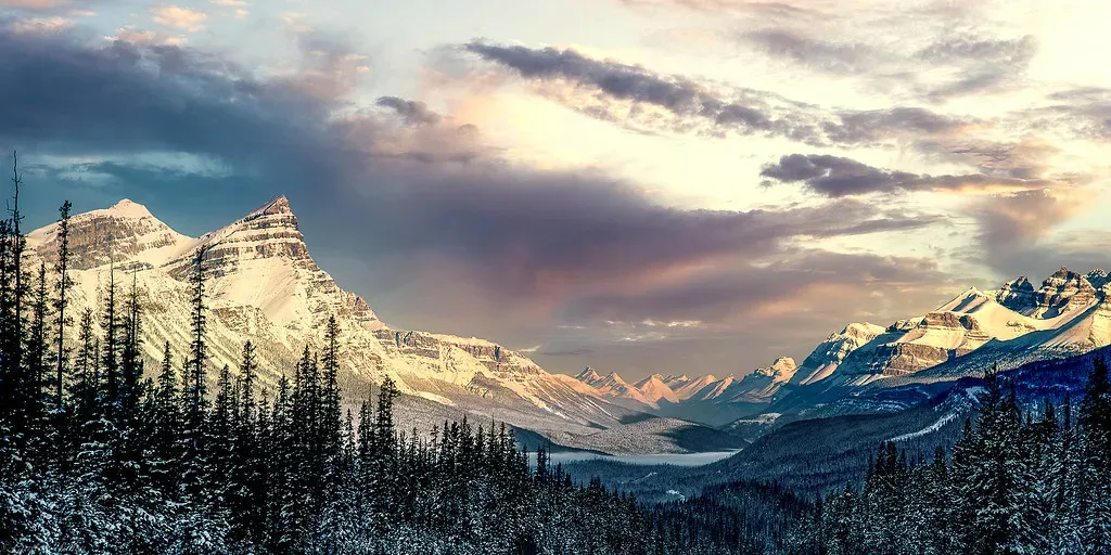
The Rocky Mountains might look like they popped up randomly in the middle of the continent, but their roots reach down into the deep engine of plate tectonics. Roughly tens of millions of years ago, an oceanic plate was forced beneath North America at an unusually shallow angle. Instead of diving steeply into the mantle, it scraped far inland, buckling and thickening the crust like a rug bunching up on a floor. That squeeze from below helped lift a massive swath of the continent into the sky, giving birth to the Rockies.
These mountains have been rising, eroding, and reshaping themselves ever since. Rivers slice down through the uplifted rock, carrying sediment away toward distant plains and coasts. Frost, gravity, and landslides peel back peaks and cliffs a little at a time, exposing older layers and creating the jagged ridgelines hikers love today. You can see the evidence of this long struggle in tilted strata, folded bands of sedimentary rock, and ancient volcanic intrusions now stranded high above the modern landscape.
Hawaiian Islands: Volcanoes Building Mountains from the Sea
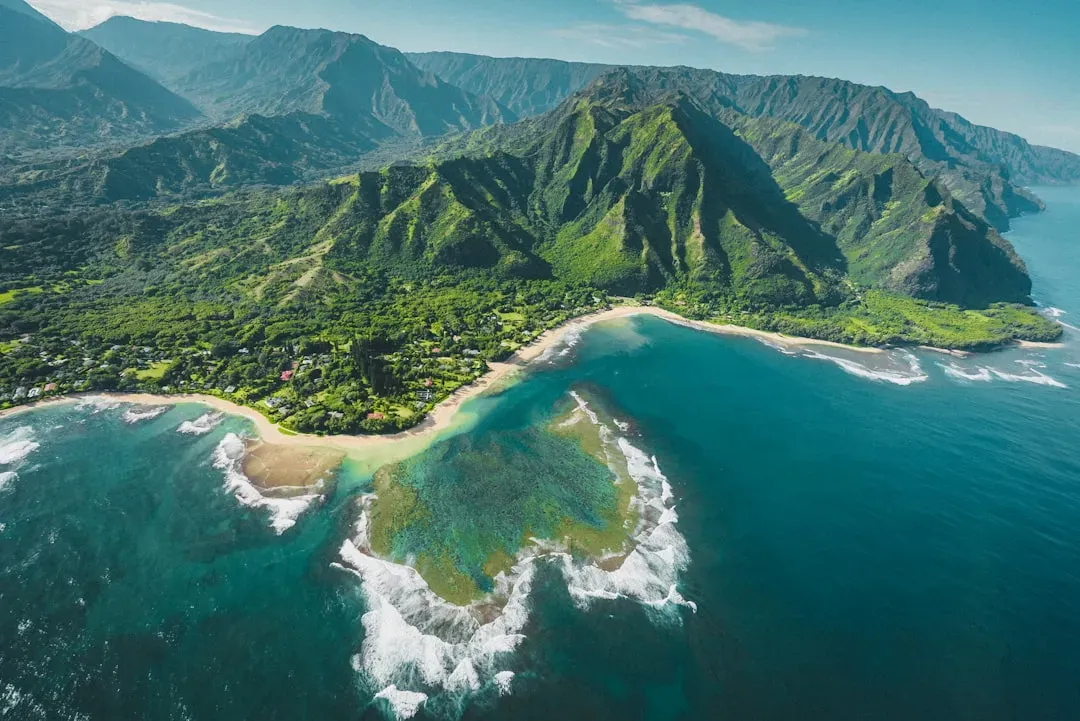
The Hawaiian Islands are proof that the seafloor itself can grow mountains taller than anything on land. Deep beneath the Pacific Plate sits a stationary hotspot – an intense upwelling of heat that melts rock and sends magma rising toward the surface. As the plate drifts over this hotspot, volcanoes form one by one, building up layer after layer of lava until they break the ocean’s surface and become islands. Older islands are carried away from the hotspot and slowly erode, while younger ones like the Big Island remain volcanically active.
Every black sand beach, lava tube, and rugged cliff in Hawaii is part of this ongoing volcanic construction project. Flows from shield volcanoes spread out in broad, gentle profiles rather than steep cones, creating that distinctive sloping island shape. Over time, waves, rain, and landslides gnaw at these volcanic piles, carving valleys and sea cliffs and collapsing parts of the coastline. Far offshore, seamounts and a new submerged volcano continue to grow, hinting that the chain of islands is not finished yet.
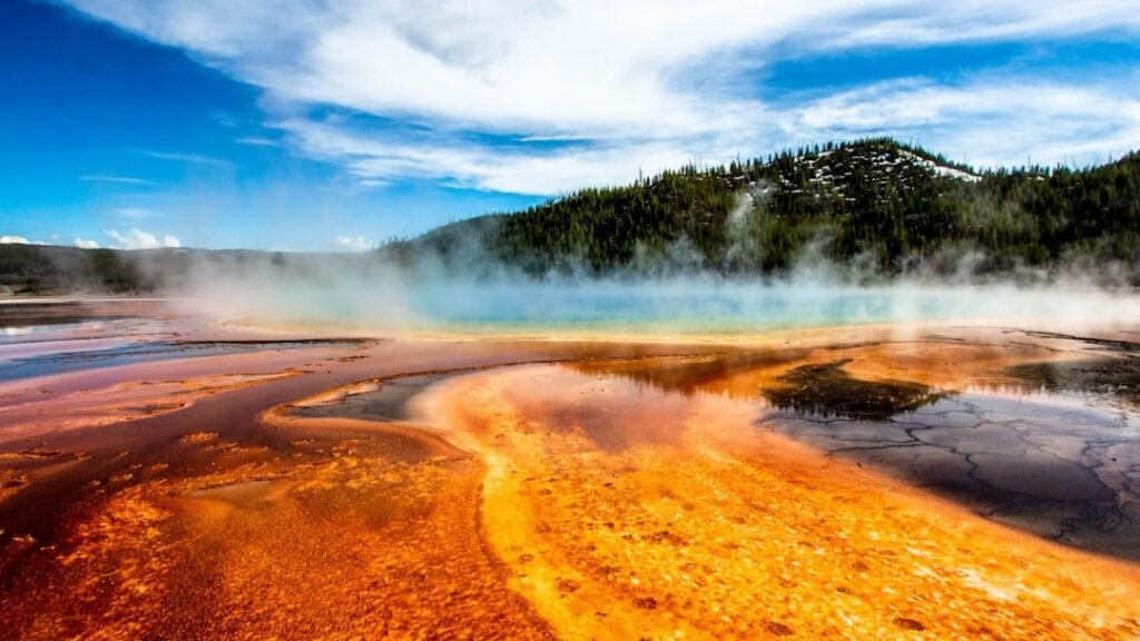
Yellowstone: A Supervolcano Hiding Beneath a Wonderland
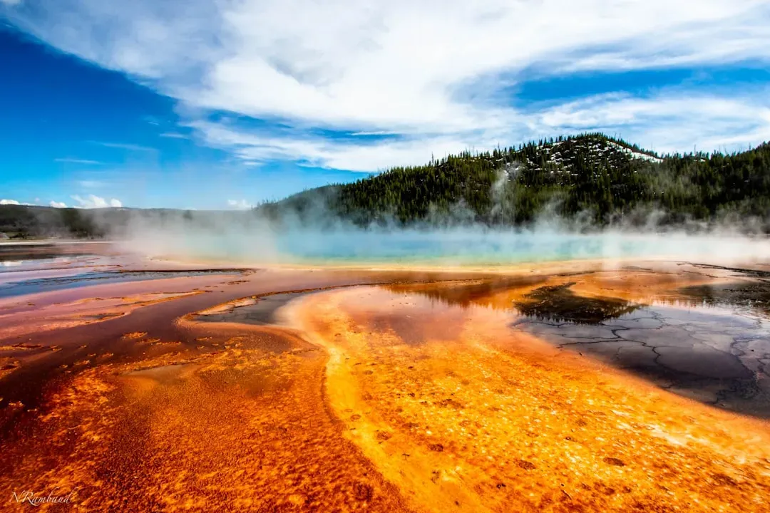
Yellowstone’s geysers and hot springs are the obvious stars, but they’re really just tiny outlets for an enormous, simmering system below. The region sits atop another powerful hotspot, where rising plumes of hot rock thin and weaken the crust. Over the past few million years, this hotspot has fueled multiple massive volcanic eruptions, each one powerful enough to blanket huge areas in ash and collapse large portions of the land into broad calderas. The modern park sits within the youngest of these gigantic volcanic depressions.
Heat from this underlying magma chamber still drives Yellowstone’s thermal features today, circulating hot water through fractures in the rock. Geysers erupt when pressure builds in these underground plumbing systems, while hot springs and mud pots mark other escape routes for heat and gas. The landscape has also been shaped by past glaciers that scoured the high plateaus, carving lakes and valleys into the softened volcanic terrain. It’s a place where deep Earth processes and surface erosion dance together in a surprisingly delicate balance.
Appalachian Mountains: Ancient Giants Worn Nearly Flat
The Appalachians don’t look as dramatic as the Rockies, but they’re far older and once rivaled the tallest ranges on Earth. Hundreds of millions of years ago, when continents collided to form the supercontinent Pangaea, enormous compressional forces crumpled sedimentary layers, thrusting them upward into towering mountains. Those collisions welded together chunks of crust from different directions, leaving behind a tangled belt of metamorphic and sedimentary rock stretching from Alabama to Canada.
Since then, erosion has been quietly grinding those peaks down like sandpaper on a sculpture. Rivers have carved winding valleys, and weathering has softened ridges into the rolling profiles you see along the Blue Ridge Parkway. Coal seams, folded strata, and exposed ancient cores tell the story of once violent tectonic clashes that have mellowed into gentle hills. From a geological perspective, the Appalachians are like elderly mountains – tough, deeply scarred, and long past their wild youth.
Great Plains: A Vast Sediment Blanket Over a Broken Past
At first glance, the Great Plains look almost featureless – a massive, flat expanse stretching from Texas into Canada. Underneath that apparent simplicity is a complicated history of mountain building, erosion, and inland seas. As the Rockies and other uplifts rose to the west, they began shedding enormous volumes of sediment. Rivers carried that debris eastward, slowly burying older landscapes under thick layers of sand, silt, and clay that eventually formed the broad, gentle slopes of the plains.
In earlier ages, shallow seas repeatedly flooded parts of the interior, leaving marine sediments that now appear as chalk cliffs, shale outcrops, and fossil-rich layers. Over time, wind and water reworked these deposits, creating subtle rises, river valleys, and badlands where the softer rock was cut away. The result is a landscape that feels calm at the surface but hides a record of rising mountains, vanishing oceans, and long‑distance sediment transport beneath your feet.
Florida and the Gulf Coast: Landscapes Built from Ancient Seas
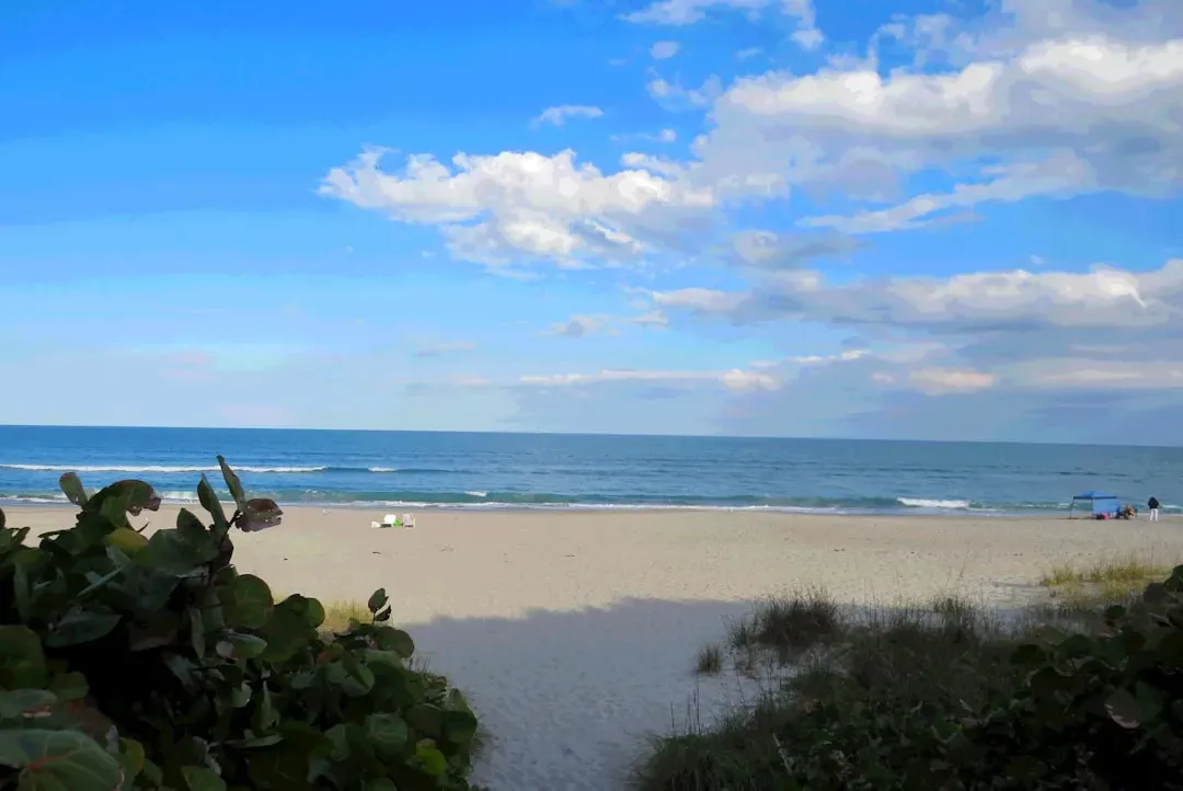
Much of Florida and the Gulf Coast exists because of long‑lived, warm, shallow seas that once covered the region. Instead of being built from volcanic rock or uplifted crust, these low‑lying areas are mostly made of limestone and other deposits formed from shells, corals, and marine organisms. Over millions of years, layer upon layer of these tiny calcium carbonate skeletons accumulated, hardened, and were later exposed as sea levels fell and rose again.
The flatness of Florida is a clue that tectonic forces here have been relatively quiet compared to the West. But water has been an incredibly powerful sculptor, dissolving limestone below the surface to create sinkholes, underground rivers, and vast aquifer systems. Coastlines, barrier islands, and wetlands along the Gulf change as waves, storms, and rising seas rearrange sediments. It’s a landscape that feels fragile because it is – constantly negotiated between land and ocean, and easily reshaped by even modest shifts in sea level.
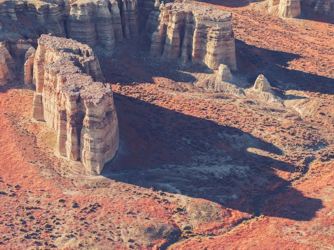
Arches and Canyonlands: Rock, Time, and a Little Bit of Luck
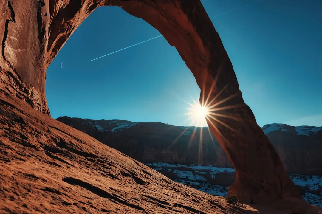
The sandstone arches and hoodoos of Utah look almost like deliberate sculptures, but they’re the accidental outcome of water, salt, and fractures working together over immense spans of time. These regions were once covered by thick layers of sediment laid down in deserts, rivers, and shallow seas. Later, uplift raised the entire area, and underground salt deposits shifted and warped the overlying rock, creating cracks and zones of weakness. Water seeped into those fractures, slowly dissolving and eroding the rock along those lines.
Freeze‑thaw cycles, chemical weathering, and gravity then exploited those weaknesses, leaving behind fins, towers, and eventually arches where softer material vanished and stronger layers held on a little longer. Wind adds the finishing touches, sandblasting exposed surfaces into smooth curves and delicate edges. Every arch is temporary on geological timescales, destined to collapse one day as erosion keeps going. The fact that we’re alive at the brief moment when so many of them still stand feels a bit like catching fireworks at the perfect second.
Alaska’s Glacial Kingdom: Ice as a Master Carver
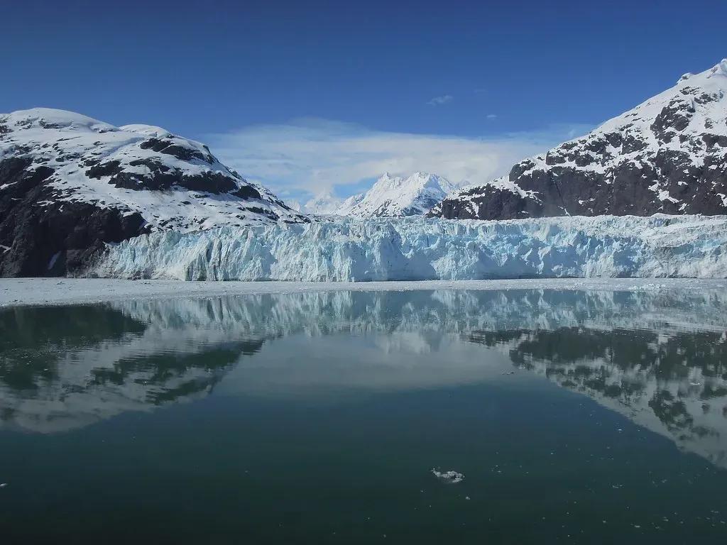
Alaska shows what happens when the forces that shaped Yosemite and the Rockies get turned up several notches. Active tectonic collisions still push up immense mountain ranges like the Alaska and Chugach Mountains, while cold climates feed powerful glaciers that pour down to meet the sea. These glaciers carve deep fjords, over‑steepened valleys, and jagged peaks known as horns, leaving behind landscapes that look almost too dramatic to be real. In some coastal regions, the land is still rebounding upward after being freed from the weight of past ice sheets.
As glaciers advance and retreat, they scrape away soil and loose rock, exposing bare bedrock and leaving behind piles of debris called moraines. Meltwater streams carry sediment into braided rivers and deltas, constantly rearranging channels and shorelines. Volcanic activity in parts of Alaska adds another layer of complexity, building new mountains and ash fields on top of older, glacially sculpted terrain. The result is one of the most intensely dynamic geological theaters in the country, where the imprint of ice is written across nearly every view.
Conclusion: Reading the Stories Written in Stone
From desert canyons to volcanic islands, from ancient worn‑down ranges to newborn lava flows, the United States is a patchwork of landscapes shaped by very different forces acting over staggering amounts of time. Plate tectonics lifts and bends the crust; volcanoes build land from below; ice, rivers, wind, and waves endlessly carve it back down. What we call scenery is really a snapshot of these processes paused at one instant in a much longer movie. The cliffs, arches, plains, and mountains we love are all mid‑story, not finished products.
Once you start to see landscapes as the visible outcome of invisible forces, travel feels different. A canyon is no longer just “pretty”; it’s evidence of uplift and erosion in action. A flat plain is the quiet footprint of vanished seas and eroded mountains; a steaming geyser field whispers about magma lurking below. The next time you look out an airplane window or stand on a viewpoint in a national park, it’s worth asking yourself: if this is what the land looks like today, how many worlds did it pass through to get here?