If you’ve ever watched footage of a tornado shredding a town or a heat wave turning entire regions into ovens, you’ve probably wondered: why is the atmosphere sometimes so calm and sometimes so terrifyingly violent? Our planet can flip from gentle drizzle to city‑destroying storms with shocking speed, and it’s not random chaos. There are rules behind the madness, and once you see them, the world’s wildest weather starts to make a strange kind of sense.
We’re living in a time when extreme weather is no longer something that happens “somewhere else” to “other people.” Floods arrive in places that rarely saw them, wildfires burn longer and hotter, and records for heat, wind, and rain keep getting broken. This isn’t just about scary headlines; it’s about understanding the forces that shape the air above our heads so we can prepare, adapt, and maybe feel a little less helpless the next time the sky decides to go full drama mode.
The Invisible Engines: Heat, Moisture, and Atmospheric Instability
Behind almost every extreme weather event lies a simple trio: heat, moisture, and instability. Think of it like a pressure cooker: the heat is your stove, the moisture is the steam, and the instability is the locked lid that eventually rattles and blows. When the lower atmosphere is warm and humid but the air higher up is much colder and drier, that temperature contrast makes the air column unstable and eager to move violently. The bigger the contrast, the more energy is available to power storms, lightning, hail, and intense downpours.
Warm air can hold more water vapor than cold air, so when oceans, lakes, or moist soils pump moisture into hot air near the surface, that air becomes a loaded spring. If something triggers it to rise – like a front, a mountain, or just strong heating of the ground – the air expands and cools, water vapor condenses into clouds, and energy is released. That release is like flipping a turbo switch: towering storm clouds grow, winds strengthen, and rain rates can go from gentle to ridiculous in minutes. Extreme weather often starts with this invisible bank account of heat and moisture waiting to be spent.
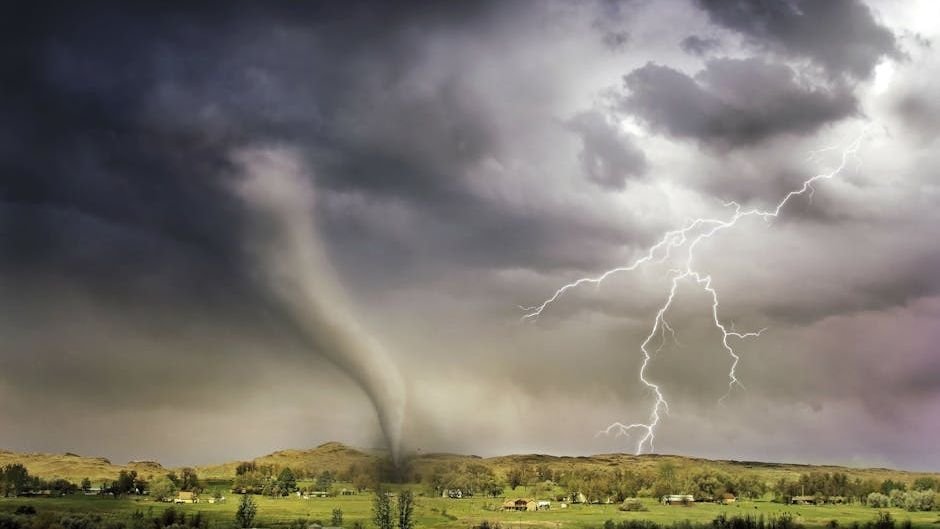
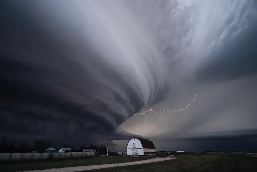
Tornadoes and Supercells: When Wind Shear Twists the Sky
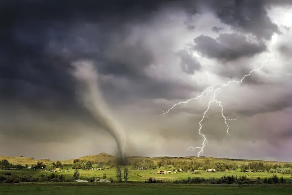
Tornadoes look like pure chaos, but they’re born from a very specific recipe, and one key ingredient is wind shear. Wind shear means winds blowing at different speeds or directions at different heights, creating invisible layers sliding past each other in the sky. When strong low‑level winds feed warm, humid air into a storm while faster, differently directed upper‑level winds blow above, a rolling, horizontal tube of air can form. A powerful updraft in a storm can then tilt this tube vertically, turning it into a rotating column of rising air.
That rotating storm is called a supercell, and it’s the heavyweight champion of severe weather producers: giant hail, violent straight‑line winds, and the most destructive tornadoes on record. Inside a supercell, the updraft can be so strong it suspends hailstones long enough to grow to the size of golf balls or even larger. Not every supercell produces a tornado, but when warm, moist inflow, strong instability, and sharp wind shear all line up, the rotation can tighten into a funnel that reaches the ground. The tornado itself is like an atmospheric figure skater pulling in their arms – once that spin tightens, wind speeds can surge to utterly devastating levels.
Hurricanes and Typhoons: Oceans Turning Heat into Monster Storms
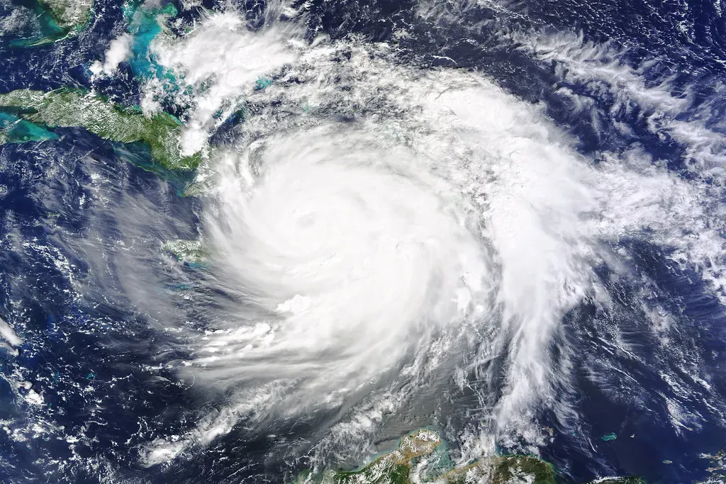
Hurricanes, typhoons, and cyclones are all the same kind of beast: massive, rotating storms that feed off warm ocean water. They’re like giant heat engines, pulling energy from the sea and releasing it into the atmosphere. When ocean surface temperatures are high enough and the upper atmosphere is relatively cool, warm, moist air rises from the sea, condenses into clouds, and releases heat. That released heat makes the air rise even faster, lowering surface pressure and drawing in more moist air from all sides in a tightening spiral.
As long as the storm stays over very warm water and vertical wind shear remains modest, the system can organize into a powerful cyclone with an eye, eyewall, and spiraling rainbands. The strongest winds cluster around the eyewall, where air is rising explosively, wrapping around a calm, clear center. Rising sea levels and warmer oceans are now allowing storms to intensify more quickly and dump far more rain than many regions are built to handle. Storm surge – sea water pushed ashore by intense winds and low pressure – often causes more deaths and damage than the winds themselves, turning coastal areas into temporary inland seas.
Heat Waves: Locked Patterns and a Slow‑Cooking Planet
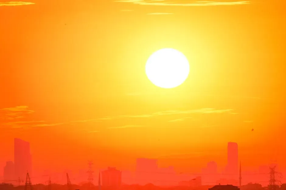
Heat waves might feel less dramatic than a tornado on video, but they quietly kill far more people, especially in cities. They’re driven by a combination of large‑scale atmospheric patterns and long‑term warming of the climate system. Often, a high‑pressure system stalls over a region, acting like a lid on a pot, trapping hot air near the surface. Under that lid, clear skies allow constant sunlight to heat the ground, and the sinking air inside the high pressure warms further as it compresses.
When these blocking patterns sit in place for days or weeks, the land dries out, reducing evaporative cooling from soils and plants and making each day even hotter than the last. Urban areas suffer even more because concrete, asphalt, and dark roofs soak up heat during the day and release it slowly at night, keeping temperatures dangerously high around the clock. As greenhouse gases accumulate, background temperatures rise, which means the “starting point” before a heat wave is warmer, so the extremes that follow become more intense and more frequent. It’s like moving the whole curve of possible temperatures upward, so records fall more often and the new normal feels nothing like the old one.
Flash Floods and Megarain: When the Sky Opens All at Once
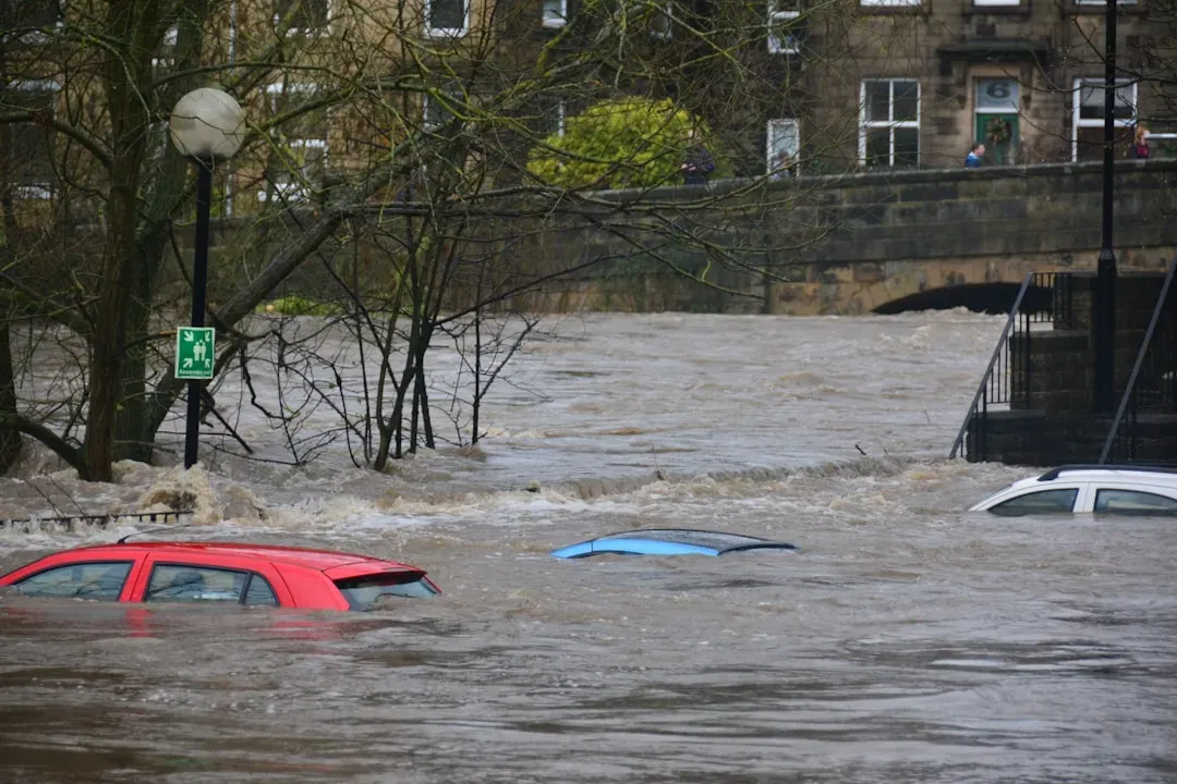
Flash floods are what happens when the atmosphere decides to deliver a month’s worth of rain in a few hours. They’re usually driven by slow‑moving or stalled storm systems that keep dumping moisture over the same region. When warm air holds a lot of water vapor – something that’s becoming more common as the climate warms – storms can wring out incredible amounts of rain. If the steering winds high in the atmosphere are weak, these storms can “train” over the same area, like a line of freight cars passing along a single track again and again.
Rivers cannot rise fast enough, drainage systems get overwhelmed, and streets can turn into rivers in minutes. Urbanization makes things worse because concrete and pavement prevent water from soaking into the ground, turning almost every drop into runoff. Mountainous regions are also vulnerable when intense rain falls on steep slopes, rapidly funneling water into narrow valleys. As the air warms, it’s able to hold noticeably more moisture, which means when the right conditions pull that moisture out, single storms can now produce truly extraordinary rainfall totals.
Blizzards and Polar Vortex Disruptions: When Cold Air Breaks Loose
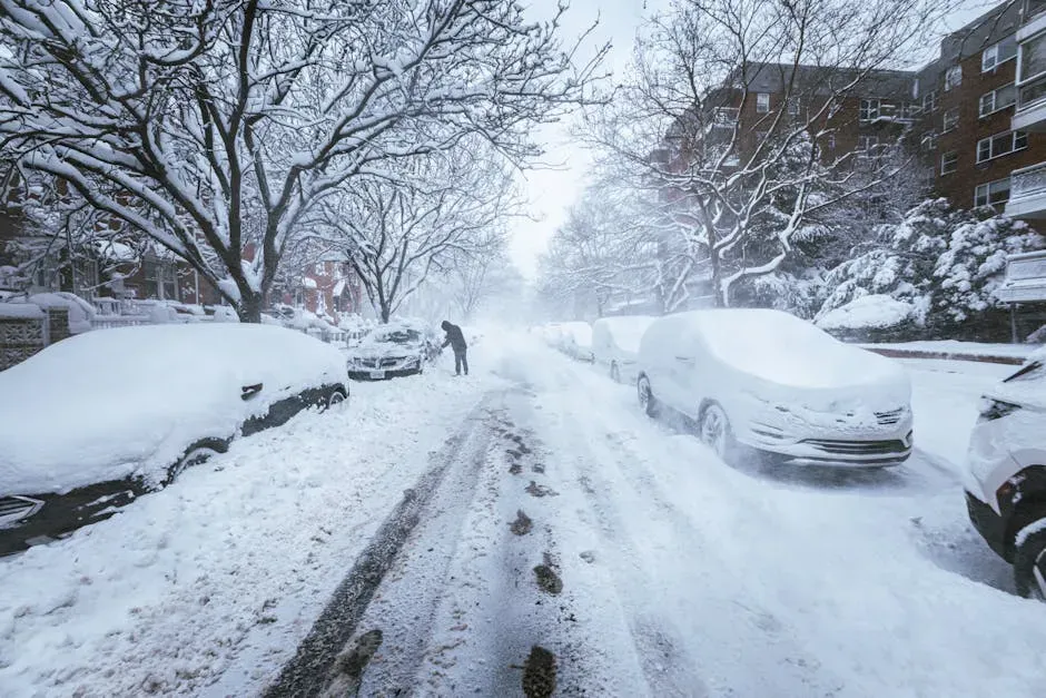
Extreme cold snaps and blizzards might seem like the opposite of a warming world, but they’re shaped by the same atmospheric physics. The polar vortex is a high‑altitude ring of strong winds around the Arctic that usually keeps frigid air bottled up near the pole. When this vortex weakens or becomes distorted, chunks of that icy air can spill southward into North America, Europe, or Asia. At the surface, if that bitter air collides with moist air from oceans or lakes, heavy snow and blizzard conditions can erupt.
Blizzards aren’t just about a lot of snow; they’re about intense winds, low visibility, and brutal wind chills that make travel or even stepping outside extremely dangerous. Warmer oceans and lakes can sometimes add extra moisture to storm systems, leading to heavier snowfall events even as seasonal averages change. There’s active research into how Arctic warming might be linked to more frequent polar vortex disruptions, but the basic idea is that changing temperature patterns can wobble the jet stream. When those wobbles deepen, cold can surge farther south than it used to, mixing with moisture and creating snowstorms that feel like something out of another century.
Droughts and Dust Storms: When Rain Disappears and Land Fights Back
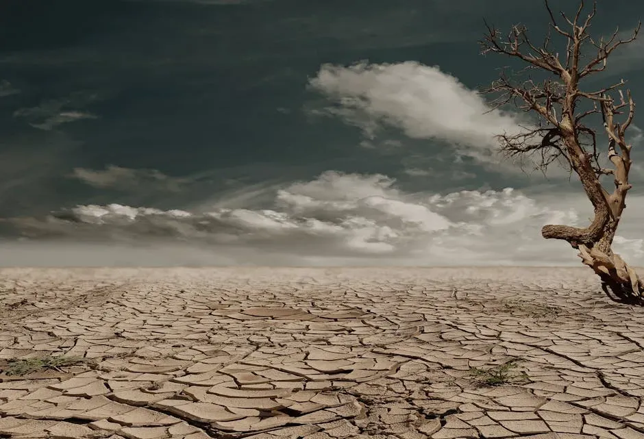
On the flip side of floods, droughts are long stretches where precipitation stays well below normal, drying out soils, rivers, and reservoirs. They’re caused by persistent shifts in weather patterns that divert storm tracks away from a region. High‑pressure systems can dominate the same area for weeks or months, keeping skies clear and blocking moisture‑bearing systems. Over time, soils lose water, crops struggle, and forests become tinderboxes waiting for a spark. The feedback loop is cruel: drier soils mean less evaporative cooling, which can lead to hotter days, further drying the land.
As vegetation withers or dies, bare soil is left exposed, and strong winds can lift loose dust and sand into the air, forming massive dust storms. These walls of dust can stretch for dozens or even hundreds of kilometers, reducing visibility to almost nothing and carrying fine particles deep into people’s lungs. Land use choices – like overgrazing, deforestation, or poor farming practices – can make regions more vulnerable by disturbing the soil and reducing plant cover. Layer climate‑driven warming on top of that, and what used to be an occasional dry spell can turn into a record‑breaking, multi‑year drought with cascading impacts on food, health, and migration.
Lightning, Hail, and Microbursts: The Smaller‑Scale Fury Inside Storms
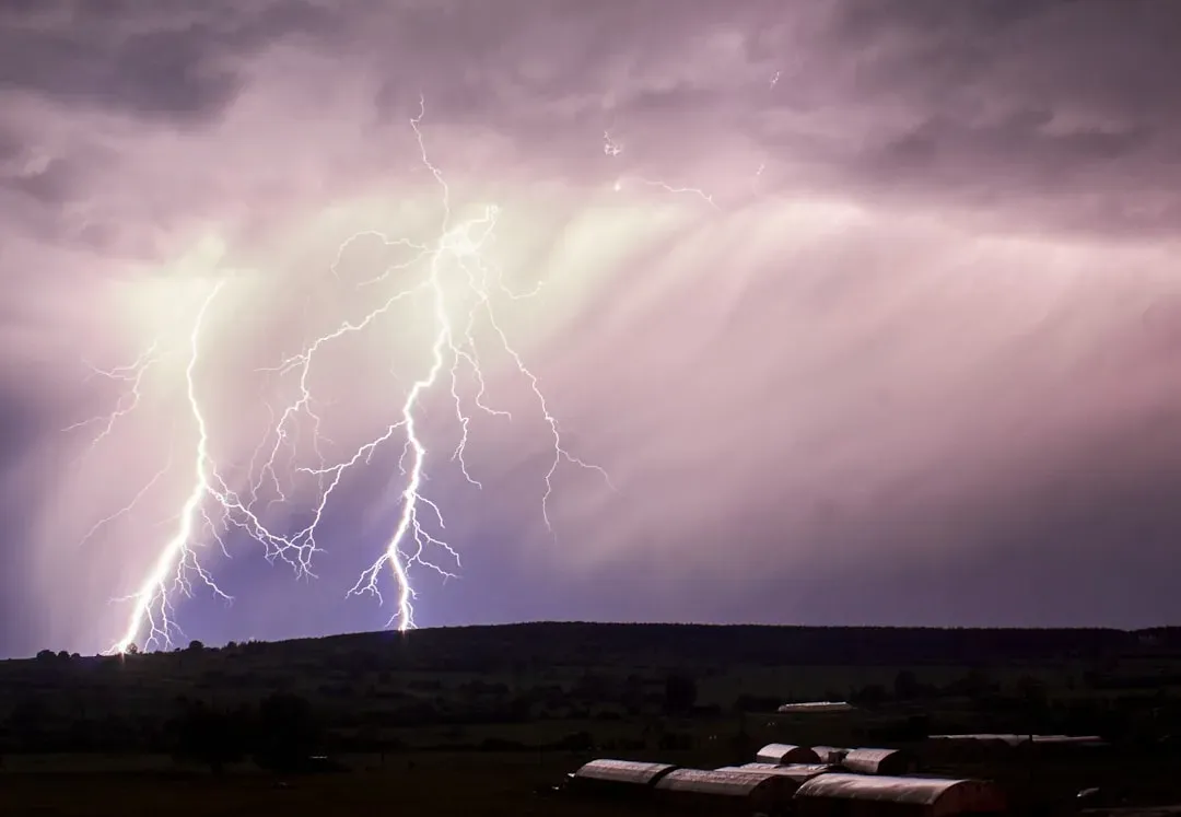
Not all extreme weather spans continents; some of the most violent events are packed into the guts of a single storm. Lightning happens when charge imbalances build up inside clouds as ice particles, hail, and raindrops collide and separate. The upper parts of the cloud become positively charged and lower parts negatively charged, eventually creating an electric field strong enough to break down the air and produce a bolt. Each strike superheats the air along its path, causing it to expand explosively and create the thunder we hear seconds later.
Meanwhile, strong updrafts inside storms loft raindrops high into freezing layers, where they accumulate additional layers of ice to become hailstones. The stronger the updraft, the longer hailstones are suspended, and the bigger they grow before gravity finally wins. Microbursts – sudden, violent downdrafts – happen when cooled, rain‑loaded air plunges downward out of a storm and slams into the ground, spreading out with damaging straight‑line winds. To someone on the ground, those winds can look and feel like a tornado, but they’re driven by a downward rush of air instead of a tight, rotating column. All of these micro‑scale phenomena are powered by the same core ingredients: instability, moisture, and sharp differences in temperature and wind within the storm.
Climate Change: Turning Up the Volume on Natural Extremes
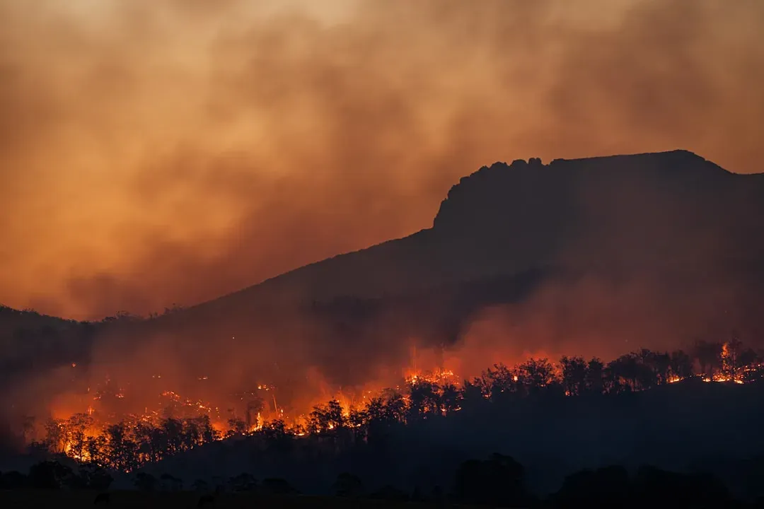
Earth has always had extreme weather, but human‑driven climate change is quietly rigging the game. By adding more heat to the climate system, we’re giving the atmosphere more energy and more moisture to work with. Warmer oceans turbocharge hurricanes and typhoons, helping them intensify faster and dump more rain. Warmer air over land makes heat waves longer and more intense, turns moderate dry spells into severe droughts, and helps fuel more destructive wildfire seasons. When storms do form, they often have more water available to release, so rainfall rates during downpours can become astonishing.
It doesn’t mean every storm, flood, or cold snap is “caused” by climate change; the atmosphere is still a complex, chaotic system with natural variations. But the baseline has shifted, like raising the floor in a house while keeping the ceiling in place. Many types of extremes that used to be rare are now happening more often, and records that once stood for decades are falling again and again. Understanding the physical triggers – heat, moisture, instability, wind patterns – and seeing how they’re being amplified gives us a way to move beyond fear and into planning. The sky will always have a wild side, but how prepared we are for it is still up to us.