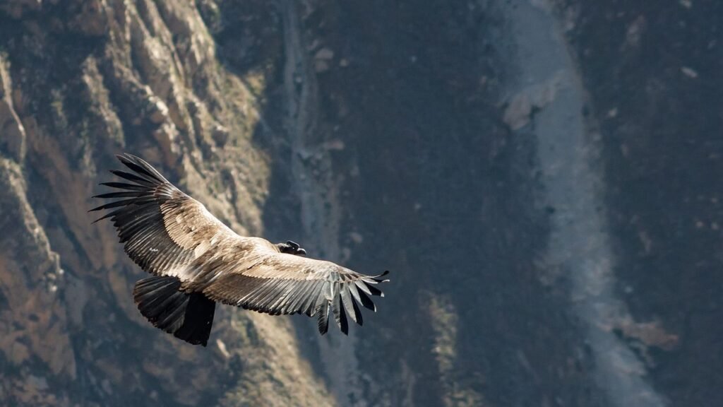
On calm days in Alaska’s Copper River Basin, the air can turn treacherous without a sign, like a trapdoor hidden in plain sight. Wildlife nose into a swale, wings dip toward a pond, and within seconds, breath runs out. The culprit isn’t a visible plume or roaring eruption but a clear, odorless gas pooling in a low place, heavier than air and quick to smother. Scientists have been quietly mapping these invisible pockets for years, piecing together how they form and when they strike. What they’ve learned reframes a chilling scene: birds that seem to drop from the sky are often entering air that simply isn’t air anymore.
The Hidden Clues
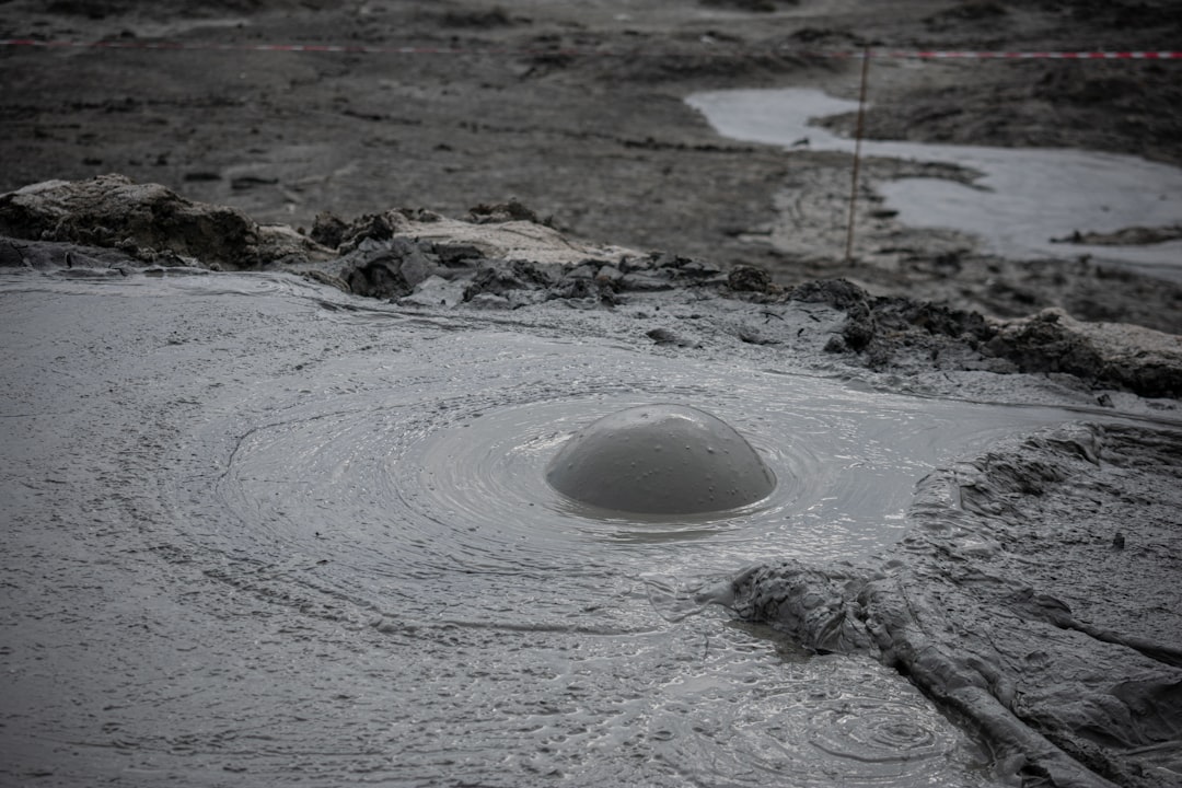
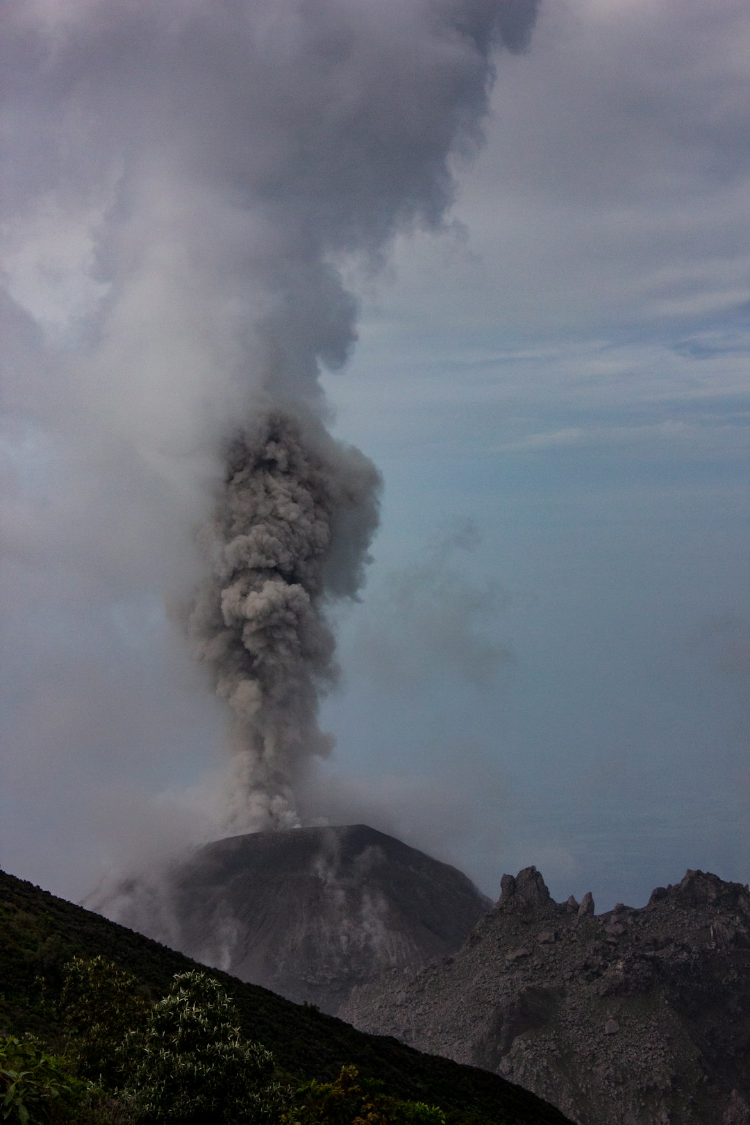
The first clues live in the landscape itself. East of Glennallen, small cones of gray mud pucker the flats near the western flank of Mount Drum, part of the Wrangell Mountains. These are the Klawasi mud volcanoes, where warm mud, hot water, and carbon dioxide bleed to the surface through old faults. When the wind is still, the gas sinks and pools in hollows, creek edges, and shallow craters, displacing oxygen at ground level. Field teams have documented localized plant kills and animal fatalities right at the vents, stark rings where life simply halts.
To a passing raven or shorebird, a quiet basin can look safe. It isn’t. Carbon dioxide is colorless and odorless, and its first symptom is often panic, not warning. A bird skimming low over a vented hollow can be overwhelmed in a breath. The scene reads as sudden collapse from above, but the mechanism is brutally simple: oxygen pushed aside by heavier gas. When thaw, weak winds, and steady seepage align, the pockets grow, then vanish when a breeze finally scrubs them clean.
What Poison Makes Air Lethal
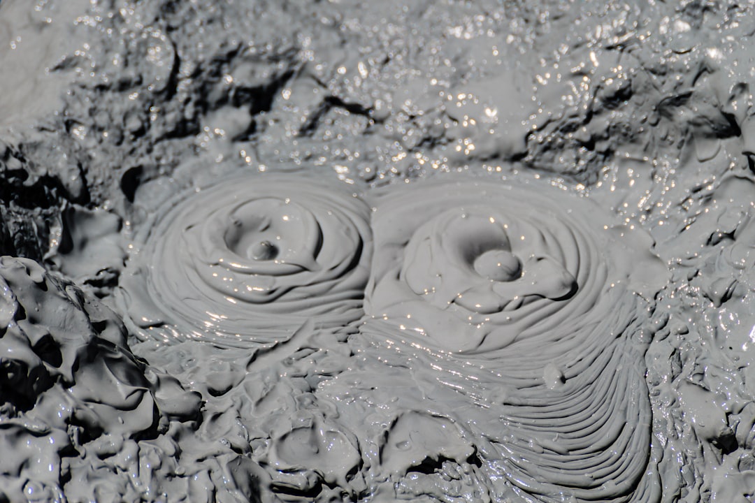
Carbon dioxide is not toxic in the usual sense; it’s asphyxiating when concentrated. At Klawasi’s Shrub cone, investigators measured gas vents composed of more than nine parts in ten carbon dioxide, with diffuse soil gas around twenty-six percent at just four inches depth. That’s enough to render small animals unconscious almost instantly and to extinguish a headlamp like a blown-out candle. The site’s estimated total upflow reaches roughly a few dozen metric tons of carbon dioxide per day, a steady, invisible tide. Most of the time the wind disperses it; sometimes the valley floor becomes a shallow bowl of unbreathable air.
The chemistry is straightforward but spooky. Because carbon dioxide is heavier than ambient air, it slumps downslope, snaking along microtopography. Snow and dense brush can act as a lid, trapping pockets close to the ground. That is why still mornings, spring thaws, and windless evenings are riskier, particularly near small basins and tree wells. It’s a phenomenon mirrored at other volcanic zones, from California’s Mammoth Mountain to European mofettes, where tree kills outline the contours of gas seepage.
From Ancient Tools to Modern Science
For centuries, people relied on animals as early-warning systems in bad air, an approach as crude as it was lifesaving. Today the toolkit is different, and far better. Scientists use handheld multi-gas meters to sniff out carbon dioxide and sulfur compounds while logging wind and temperature. Thermal cameras and satellite imagery flag warm, wet ground where gas and fluids rise, and repeat drone flights stitch together maps of where hazards migrate after freeze–thaw cycles. In summer, soil-flux arrays measure how quickly gas leaks into the air; in winter, probes test what accumulates under snowpacks and inside depressions. Together, these methods convert a hidden hazard into data you can see.
I keep a pocket CO2 meter in my gear bag because the first time I watched one spike near a training vent, the number felt like a slap. It’s one thing to read a paper; it’s another to see a value climb past what’s safe and keep climbing. Those small instruments, paired with wind monitors, have changed how researchers and rangers plan routes at active seeps. They also shape how we explain risk to visitors who see only quiet ground and a pretty view. The newest push is to automate alerts, so the land itself can “ping” people when conditions turn sour.
The Valley’s Map
The Copper River Basin isn’t a single crater; it’s a patchwork of small hazards that shift with weather. Three main cones – Upper Klawasi, Lower Klawasi, and Shrub – sit near Mount Drum, with additional mud volcanoes to the west at Tolsona. The distinction matters: the Tolsona group emits mostly methane, while Klawasi’s flux is dominated by carbon dioxide, which is the real asphyxiation risk for wildlife and people. On aerial surveys, you can see fresh mud fans and warm ponds marking the active spots, then rings of stressed vegetation where gas lingers. This is a living map that changes with storms, seasons, and ground cracks.
Far to the southwest, Katmai’s famed Valley of Ten Thousand Smokes tells a different story: an ash-choked landscape born of the colossal 1912 Novarupta eruption. While thousands of fumaroles once steamed there, park scientists emphasize that Alaska’s winds usually disperse volcanic gases before they pool widely. The Klawasi-style hazard is more local, tied to low topography, calm air, and steady seepage. That nuance is important for travelers who hear “volcanic gas” and imagine the whole region is unsafe. Most of Alaska’s volcanic parks are vast, windy, and safe with common sense and distance.
Why It Matters
It matters because invisible hazards bend our instincts the wrong way. Water that runs clear can be acidic; air that looks normal can be unbreathable. Traditional safety cues – smell, color, noise – don’t help with carbon dioxide pooling at ankle to chest height. Compared with the drama of lava or ash, these pockets are quieter and more easily underestimated. For wildlife, the margin for error is razor-thin when a feeding foray dips into a hollow at the wrong time. For people, a pet or child close to the ground can be at greater risk than an adult standing upright.
We also care because the lessons travel. The same physics that concentrates gas near Klawasi explains tree kills and wintertime fatalities around Horseshoe Lake at Mammoth Mountain, where snow traps carbon dioxide near the surface. And, at the tragic extreme, it explains why a volcanic lake in Cameroon once exhaled a massive cloud of carbon dioxide that poured through valleys and killed approximately 1,746 people. Put simply: what happens in a small Alaskan hollow is a scaled-down echo of global processes that turn invisible gas into a deadly flood.
Global Perspectives
Carbon dioxide seepage is not rare; it’s the context that determines danger. In many volcanic zones, steady wind and rough terrain dissolve the risk into background. Where topography forms bowls, forest litter fills hollows, or deep lakes cap gas-rich water, the equation changes. Lake Nyos was a catastrophic case because gas built up under pressure, then surged out and slid downslope like a transparent avalanche. By contrast, Alaska’s pockets are smaller and episodic, typically measured in meters and minutes, not miles and hours. The shared thread is density: heavy gas follows gravity, and valleys are gravity’s highways.
Cross-checking places sharpens practice. At Mammoth, managers post warnings and monitor snowpits; at Alaskan mud volcanoes, teams map vents, vegetation stress, and wind regimes. Technology refined in one landscape updates protocols in another. The result is a growing global playbook: know your vents, respect the wind, test low spots, and never assume clear air is safe air. It’s pragmatic, not alarmist, and it’s saved lives – from California cabins to remote Alaska drainages.
The Future Landscape

The next leap is prediction, not just detection. Researchers are pairing continuous CO2 sensors with micro-meteorology stations to flag hours when pooling is most likely, then feeding those signals into simple dashboards a ranger can check on a phone. Drones can scout fresh vents after quakes or thaws and drop temporary beacons that text when levels spike. Even modest steps – like wind-threshold alerts tied to specific hollows – could cut risk for field crews and wildlife biologists working near seeps. Longer term, better fault maps and satellite thermal products should help stitch fine-grained hazard models to regional forecasts. That’s a lot of science aimed at moments that last minutes.
Climate variability adds pressure. More freeze–thaw cycling, rain-on-snow events, and shoulder-season calm spells can all shift when and where gas accumulates. The goal isn’t to cordon off wild places; it’s to live with them more intelligently. In practical terms, that means keeping field protocols nimble and sharing data across parks and agencies. It also means designing visitor guidance that talks about low-air hazards as plainly as it talks about bears and river crossings. We can’t see the danger, so we need to name it clearly.
Conclusion
If you work or wander near Alaska’s volcanic country, make “invisible air” part of your field checklist. Stay high and upwind in calm conditions, avoid hollows and stream margins near active seeps, and never dig snow shelters where tree-kill or warm, wet ground suggests gas. Carry a basic multi-gas meter if you spend time off-trail in known seep areas, and teach kids to keep heads above snowbanks and ground depressions. If an animal or person collapses in a hollow, resist the urge to rush in – move upslope, create airflow, and approach from high ground with caution. Small habits prevent big tragedies. Did you expect air to be this complicated?

Suhail Ahmed is a passionate digital professional and nature enthusiast with over 8 years of experience in content strategy, SEO, web development, and digital operations. Alongside his freelance journey, Suhail actively contributes to nature and wildlife platforms like Discover Wildlife, where he channels his curiosity for the planet into engaging, educational storytelling.
With a strong background in managing digital ecosystems — from ecommerce stores and WordPress websites to social media and automation — Suhail merges technical precision with creative insight. His content reflects a rare balance: SEO-friendly yet deeply human, data-informed yet emotionally resonant.
Driven by a love for discovery and storytelling, Suhail believes in using digital platforms to amplify causes that matter — especially those protecting Earth’s biodiversity and inspiring sustainable living. Whether he’s managing online projects or crafting wildlife content, his goal remains the same: to inform, inspire, and leave a positive digital footprint.