Hurricane Idalia arrived like a switch flipped in the night – dark water rising into quiet streets, tree lines bowing, and radar blossoms sharpening with unnerving speed. Behind that drama sits a deeper story about oceans warming, winds shifting, and our models racing to keep up. The U.S. has endured a drumbeat of supercharged storms in recent years, each exposing a new weak seam in our infrastructure and assumptions. Scientists now track not just where a storm will go, but how fast it might explode in strength – sometimes within a single commute. That evolving science is urgent, messy, and surprisingly hopeful, because every increment of understanding can shave risk from the next landfall.
The Hidden Clues
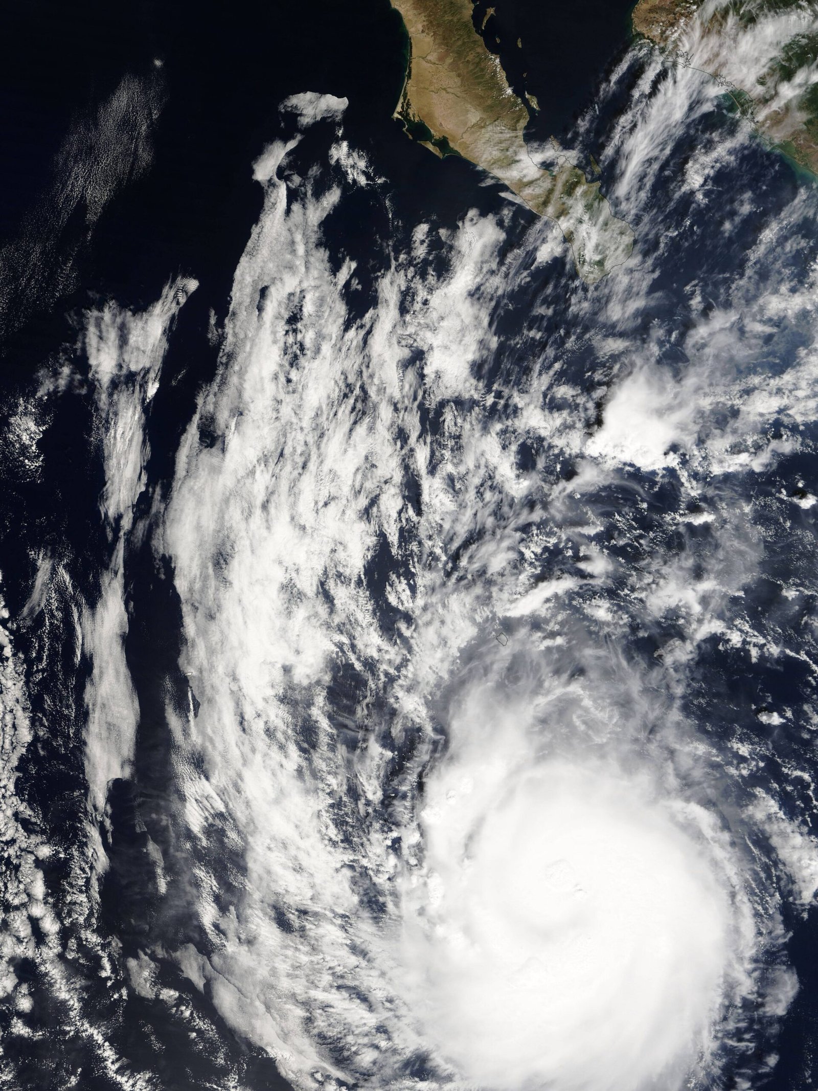
What tips a storm from routine to ruinous? It often starts below the waves, where pools of deep, bath-warm water act like jet fuel for tropical cyclones. When forecasters saw the Gulf of Mexico simmering ahead of Idalia, they flagged high ocean heat content – not just warm at the surface, but warm dozens of meters down – meaning waves and wind could not easily churn up cooler water to slow the storm. In the atmosphere above, low vertical wind shear created a calm corridor for Idalia’s core to organize. Add a moist air mass and a favorable steering pattern, and the ingredients were quietly, perfectly aligned.
I remember watching overnight model runs as Idalia’s pressure dropped faster than felt fair, the way a campfire catches when a new log finally breathes. Those early, subtle signals – heat content maps, shear analyses, and microwave satellite glimpses of a tightening eyewall – became the telltale whispers before the roar. They’re not flashy on TV, but they’re the leading indicators that separate a bad day from a historic one. And lately, those whispers arrive more often and grow louder, especially over anomalously warm water.
Anatomy of a Superstorm

A hurricane is a heat engine: warm, humid air rises near the center, cools aloft, and sinks outward – an elegant, brutal loop that strengthens as long as fuel and structure hold. Rapid intensification happens when that loop becomes exquisitely efficient, tightening the eyewall like a figure skater pulling in their arms. Eyewall replacement cycles can briefly weaken winds while expanding the wind field, spreading damage across a wider area. Size matters as much as peak strength; a broader storm drives a more formidable surge and longer-lasting battering of the coast.
Rainfall is its own storyline, especially when steering currents stall and storms linger, wringing moisture like a soaked towel over one place. Surge, meanwhile, is where physics meets geography: shallow continental shelves and concave shorelines can amplify water push dramatically. Pair a swollen ocean with a broad wind field and you get flooding that feels less like a wave and more like a slow, relentless tide climbing stairs. That is why some communities far from a storm’s eye still get devastated.
From Ancient Tools to Modern Science
Storm tracking once depended on ship logs, barometers, and coastal observers; today we have fleets of satellites, high-altitude aircraft, and ocean robots feeding models with a firehose of data. Hurricane Hunter planes drop instrumented probes – dropsondes – through the core, measuring temperature, humidity, and winds from cloud top to sea spray. Doppler radar scans reveal rotating bands and evolving eyewalls, while microwave sensors see through cloud canopies to the rain band skeleton. Ocean gliders and autonomous saildrones patrol warm pools, sampling the fuel before storms drink it.
The forecasting revolution, though, is computational. High-resolution models now resolve the violent physics inside the eyewall, and ensemble systems explore thousands of possible futures, not just one. Early machine-learning tools sift patterns humans miss, especially for rapid intensification odds close to shore. None of it is perfect, but the aim is practical: earlier, sharper warnings that communities can actually act on.
Why Idalia Stood Out
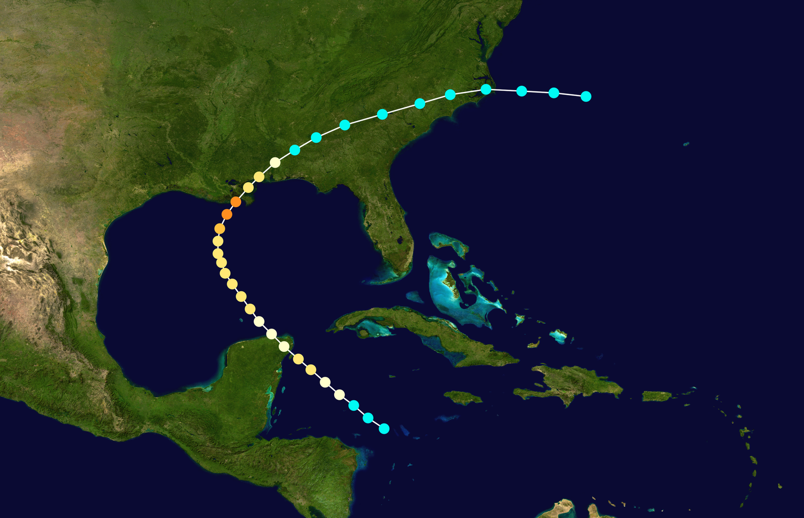
Idalia’s path over deep, hot Gulf waters and into Florida’s Big Bend created a worst-case pairing: maximum fuel upstream and a coastline shaped to magnify surge. The region’s shallow shelf and concave geometry helped pile water into bays and marshes, turning quiet inlets into fast-rising floodplains. Low wind shear let the storm’s core stack vertically and organize quickly, padding intensity in the final approach. Idalia became the strongest hurricane to strike the Big Bend in more than a century, a stark reminder that quieter stretches of coastline are not safe so much as untested.
What also made Idalia notable was timing and pace – strengthening close to land left little margin for last-minute preparation. Power grids, small hospitals, and rural road networks were stressed in ways that differ from big-city landfalls. For many, evacuation decisions hinged on hours, not days, and on surge maps few had studied before. That pattern – late, fast, and coastal – is exactly the puzzle scientists are trying to solve first.
Storms That Redefined Recent Years
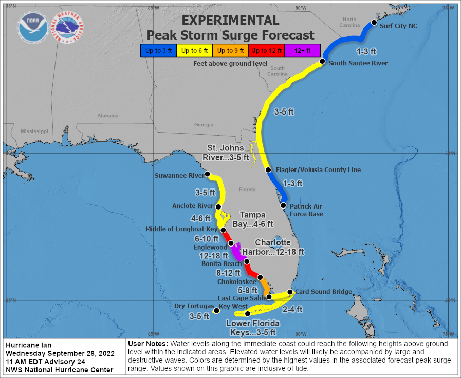
The past decade has delivered a rough education in hurricane diversity. Michael roared ashore in the Florida Panhandle with extreme winds that shredded forests and reshaped beaches. Harvey stalled over Texas and turned highways into rivers, proving how a slow storm can be more ruinous than a strong one. Ian’s surge swamped neighborhoods along Florida’s southwest coast, its water footprint dwarfi ng the damage that wind alone would have done. And Beryl, an astonishing early-season overachiever in 2024, reminded everyone that the calendar is a poor comfort when the ocean runs hot.
Consider a few anchors for perspective: – Michael showed how compact, intense cores can produce outsized wind damage far inland. – Harvey exposed the risk of urban flooding when a storm’s forward motion collapses. – Ian underscored surge vulnerability in low-lying developments built during quieter decades. – Beryl demonstrated that record-warm waters can turbocharge storms weeks earlier than many residents expect.
Why It Matters
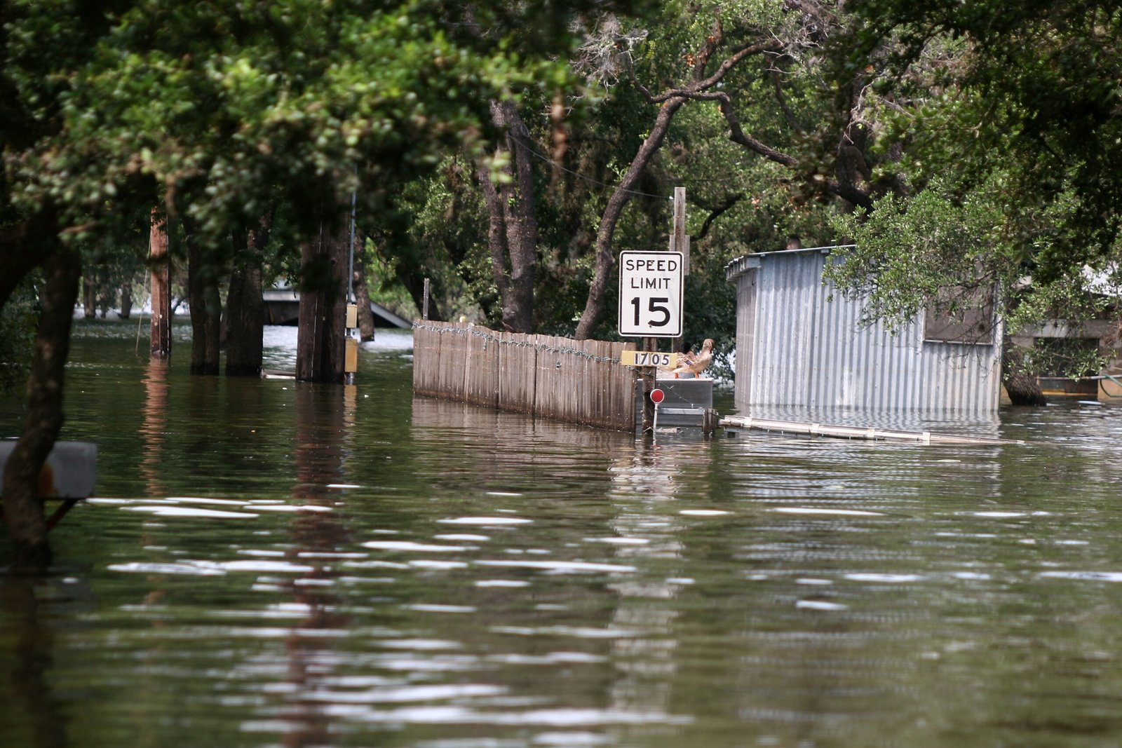
Storm science is not trivia; it’s the blueprint for keeping people alive and economies intact. Traditional risk maps often lag reality because they were calibrated on twentieth-century seas and neighborhoods. When seas rise by roughly about eight inches since the late 1800s, the same wind now pushes higher water, turning a “manageable” surge into a home-wrecking flood. Meanwhile, more frequent rapid intensification compresses the window between watch and warning, which strains evacuation logistics, hospital transfers, and grid pre-staging.
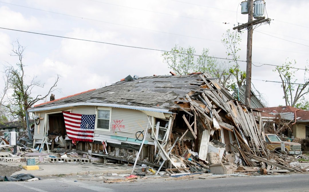
There’s also the money math: rebuilding the same way compounds losses, while resilient design often pays for itself after a single bad season. Older building codes fared poorly in recent storms compared with modern wind and flood standards, a gap visible block by block after landfall. Flood insurance uptake remains thin in many surge-prone zip codes, leaving families with losses that federal aid rarely covers fully. The science is clear enough to act, and the cost of waiting keeps showing up in the ledger.
The Future Landscape
What’s next is a blend of sharper tools and humbler expectations. Uncrewed aircraft, ocean gliders, and surface drones will map the air–sea handshake inside storms in real time, feeding models that finally resolve the small-scale bursts that drive intensification. New surge models fuse tides, waves, and river flow so emergency managers can target street-level warnings rather than paint whole counties with the same brush. AI-assisted nowcasting may flag dangerous strengthening hours earlier, nudging people to move before traffic locks up.
The challenge is translating precision into protection. Coastal upgrades – smarter grids, elevated substations, and floodable parkways – will compete with housing costs and politics. Nature-based buffers like marshes and mangroves can trim surge, but they need space and patience to grow. And even the best forecast can’t help if warnings aren’t trusted; risk communication has to be as local and human as a neighbor knocking on the door at dawn.
Conclusion

Start by knowing your zone: if you live where surge maps turn blue, make an evacuation plan that doesn’t rely on last-minute traffic miracles. If you own, ask a contractor about inexpensive wind upgrades like garage-door bracing and roof-deck sealing, which can make the difference between repair and ruin. Check whether your homeowner’s policy excludes flood – and assume it does – then price a separate policy before the season, not during it. Back up essentials, from medical records to phone chargers, and store them high, not just handy.
Support the upstream work, too. Encourage local officials to preserve wetlands and dunes, because green infrastructure can blunt the blow when concrete can’t. Pay attention to rapid intensification forecasts and treat them like a fire alarm, not a weather curiosity. And if you’re far from the coast, remember that inland floodplains and weak grids are part of the same story, which means your preparation still counts.

Suhail Ahmed is a passionate digital professional and nature enthusiast with over 8 years of experience in content strategy, SEO, web development, and digital operations. Alongside his freelance journey, Suhail actively contributes to nature and wildlife platforms like Discover Wildlife, where he channels his curiosity for the planet into engaging, educational storytelling.
With a strong background in managing digital ecosystems — from ecommerce stores and WordPress websites to social media and automation — Suhail merges technical precision with creative insight. His content reflects a rare balance: SEO-friendly yet deeply human, data-informed yet emotionally resonant.
Driven by a love for discovery and storytelling, Suhail believes in using digital platforms to amplify causes that matter — especially those protecting Earth’s biodiversity and inspiring sustainable living. Whether he’s managing online projects or crafting wildlife content, his goal remains the same: to inform, inspire, and leave a positive digital footprint.