
They look like scars, thin and near-invisible from the surface, yet ocean trenches mark the places where Earth flexes its greatest muscle. In these drowned canyons, continents are nudged, oceans are recycled, and the seeds of tsunamis and volcanoes are set. Scientists chase faint signals rattling through rock and water to read what the trenches are planning next. The mystery is simple to state and hard to solve: how do we watch the planet’s most powerful collisions when they happen miles below a storm-tossed sea? New tools are finally letting us listen in, and the story they tell is both sobering and full of promise.
The Hidden Clues
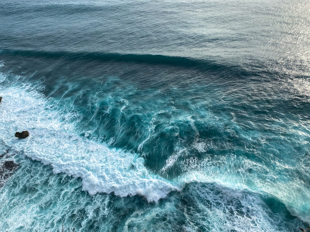
At depths reaching nearly seven miles in the deepest trenches, where pressure crushes like a stack of skyscrapers, the seabed folds into trenches that act like seismographs written in stone. Every bend and ripple there records a struggle between plates, one diving, one resisting, both reshaping the crust. The subducting slab drags earthquakes along a slanted corridor called a Wadati–Benioff zone, a kind of subterranean runway for shocks. In the darkness, water squeezed from sinking rocks greases faults and sparks melting, linking trenches to volcanic arcs ashore. Even the cold chemistry is a clue: minerals transform, releasing fluids that travel upward like whispered messages.
The first time I watched a research vessel’s sonar trace a trench, the screen looked like a heartbeat spiking into silence. That thin, steep wall explained entire mountain ranges, whole coastlines, and the history of disasters stamped into tide gauges. It also warned that what matters most may be the quiet intervals, when stress builds invisibly. Trenches hide their intent well, but their clues are everywhere once you know how to look.
From Ancient Tools to Modern Science
We began with weighted lines and sketchy charts, mapping the abyss one clumsy sounding at a time, and still missed the scale of the forces below. Satellite altimetry later traced subtle bumps and dips in sea level to reveal seafloor shapes, and multibeam sonar sharpened them into crisp landscapes. Today, swarms of ocean-bottom seismometers listen for tiny quakes, while deep-towed instruments sniff for warm fluids seeping through newly opened cracks.
Submersibles and remotely operated vehicles ground-truth those maps, sampling rocks and microbes that survive at pressures roughly a thousand times what we feel at the surface. Machine learning sifts years of tremor and pressure data to find patterns human eyes would skip, turning noise into a narrative.
Anatomy of a Boundary
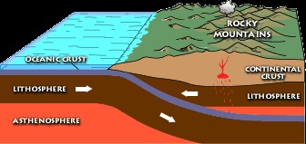
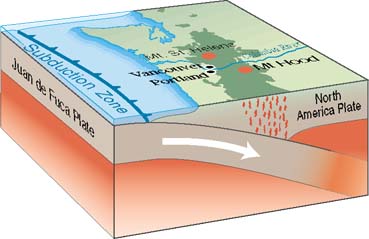
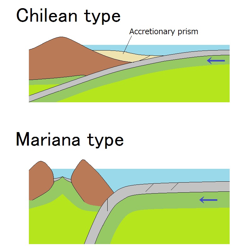
All plate boundaries move, but trenches belong to convergence, the domain of subduction where one plate bows and slides beneath another. At the seafloor, the meeting line can build an accretionary wedge of scraped sediment or carve an erosive front that bites rock away, depending on the angle and speed. Down-dip, the slab bends, heats, and dehydrates, releasing water that lowers melting temperatures in the mantle wedge above.
That dehydration-to-magma pipeline fuels chains of volcanoes like a necklace shadowing the trench, from the Andes to island arcs in the Pacific. Meanwhile, the upper plate may lock hard or creep, storing or bleeding off strain that decides whether the next rupture is a whisper or a roar. The trench itself is only the surface signature of a three-dimensional machine reaching deep into the mantle.
The Physics in the Dark
At many trenches, the shallowest part of the fault can act like wet clay, while a deeper patch locks tight – an arrangement that loads the system for rare, devastating slips. Slow-slip events, lasting days to months, release energy too gently for people to feel yet can reset the clock for the next big quake. Fluids moving along fractures behave like hidden levers, changing friction and dictating when and where the fault will slide.
Temperature controls the choreography, with cooler slabs carrying earthquakes deeper and hotter ones forcing a transition to ductile flow sooner. In the deepest reaches, high-pressure minerals act like shape-shifters that stiffen or soften the slab, guiding the path of quakes we detect far ashore.
Global Perspectives
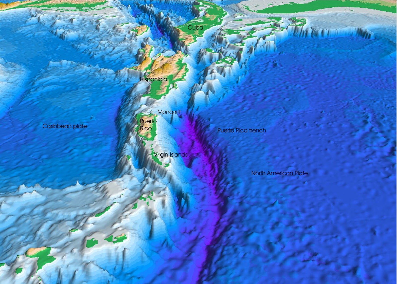
Not all trenches are equal. The Mariana and Tonga–Kermadec systems plunge the fastest and deepest, while the Peru–Chile and Japan trenches pair ocean-floor chasms with coastlines that have seen the full spectrum of seismic behavior. The Puerto Rico Trench guards the Atlantic’s deepest point and reminds us that major hazards do not belong only to the Pacific Ring of Fire.
Each setting blends plate age, convergence rate, sediment load, and geometry into a unique hazard recipe. Some margins favor tsunamis when shallow portions of the fault rupture and shove the overlying water column; others channel energy into shaking that topples cities but raises smaller waves. Understanding which flavor a trench prefers can transform preparedness from guesswork into strategy.
Why It Matters
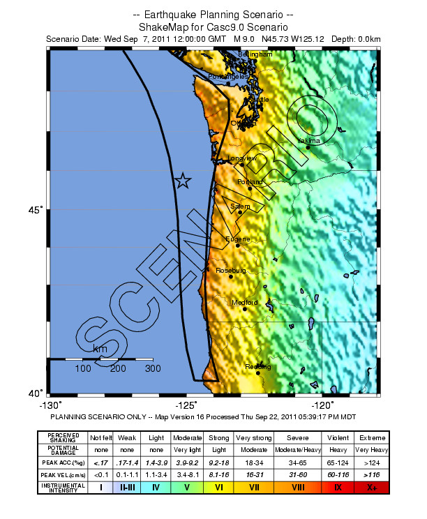
The stakes extend far beyond geophysics. Coastal megacities, ports, and power grids sit within a day’s drive of many trenches, and the planet’s largest earthquakes overwhelmingly nucleate on subduction zones. Insurance markets, supply chains, and emergency planning hinge on how precisely we can model the next rupture.
There’s also the long view: subduction is Earth’s recycling program, dragging water and carbon into the deep and venting some back through volcanoes that feed soils and shape climates over millions of years. Compared with early textbook sketches that treated boundaries as tidy lines, today’s trench science reveals layered, migrating, and sometimes surprising behaviors – nuance that can save lives when translated into building codes and warnings.
Signals We Can Use
Trench-focused monitoring is shifting from sparse moorings to dense, networked ears on the seafloor. Deep-ocean pressure sensors track tsunami-generating bulges and dips in the water column, while cabled observatories stream real-time vibrations and fluid chemistry back to shore. Fiber-optic seafloor telecommunication lines are being repurposed as thousands of distributed earthquake sensors, turning quiet cables into continent-scale microphones.
On land, GPS and satellite radar measure millimeters of motion as plates tug at coastlines connected to the trench. When we fuse those signals, models no longer chase the last disaster – they anticipate the next scenario with tighter bounds and clearer thresholds for action.
The Future Landscape
The push to map the entire ocean floor at high resolution by 2030 promises to fill in dangerous blanks along many trenches. Uncrewed surface vessels and autonomous underwater vehicles can sweep remote arcs for weeks, dodging storms and cutting costs that once kept scientists onshore. New borehole observatories, drilled into the fault itself, aim to capture pressure and temperature changes the instant the system begins to shift.
Challenges remain: geopolitical limits on data sharing, fragile deep-sea hardware, and the sheer scale of wiring an entire planet. But the payoff is huge – a forecast system that pairs coastal evacuation plans with real-time trench diagnostics, and a climate record grounded in how subduction shuttles carbon. If we get the network right, the deep will speak plainly enough for everyone to hear.
Conclusion
Start local: learn your coastal evacuation routes, know the natural tsunami warning signs, and support drills that treat minutes like currency. Add your voice to initiatives that fund ocean mapping, cabled observatories, and open seismic data, because the information we do not collect becomes the risk we cannot manage. If you work in planning or construction, push for standards that reflect trench-driven hazards, not just historical averages.
For the rest of us, curiosity helps – follow seismic networks, pay attention to coastal advisories, and back research groups that maintain instruments in the harshest places on Earth. The trenches will keep colliding, whether we are listening or not, so let’s choose to listen now – what would you change in your community if you knew what the deep was about to do?

Suhail Ahmed is a passionate digital professional and nature enthusiast with over 8 years of experience in content strategy, SEO, web development, and digital operations. Alongside his freelance journey, Suhail actively contributes to nature and wildlife platforms like Discover Wildlife, where he channels his curiosity for the planet into engaging, educational storytelling.
With a strong background in managing digital ecosystems — from ecommerce stores and WordPress websites to social media and automation — Suhail merges technical precision with creative insight. His content reflects a rare balance: SEO-friendly yet deeply human, data-informed yet emotionally resonant.
Driven by a love for discovery and storytelling, Suhail believes in using digital platforms to amplify causes that matter — especially those protecting Earth’s biodiversity and inspiring sustainable living. Whether he’s managing online projects or crafting wildlife content, his goal remains the same: to inform, inspire, and leave a positive digital footprint.