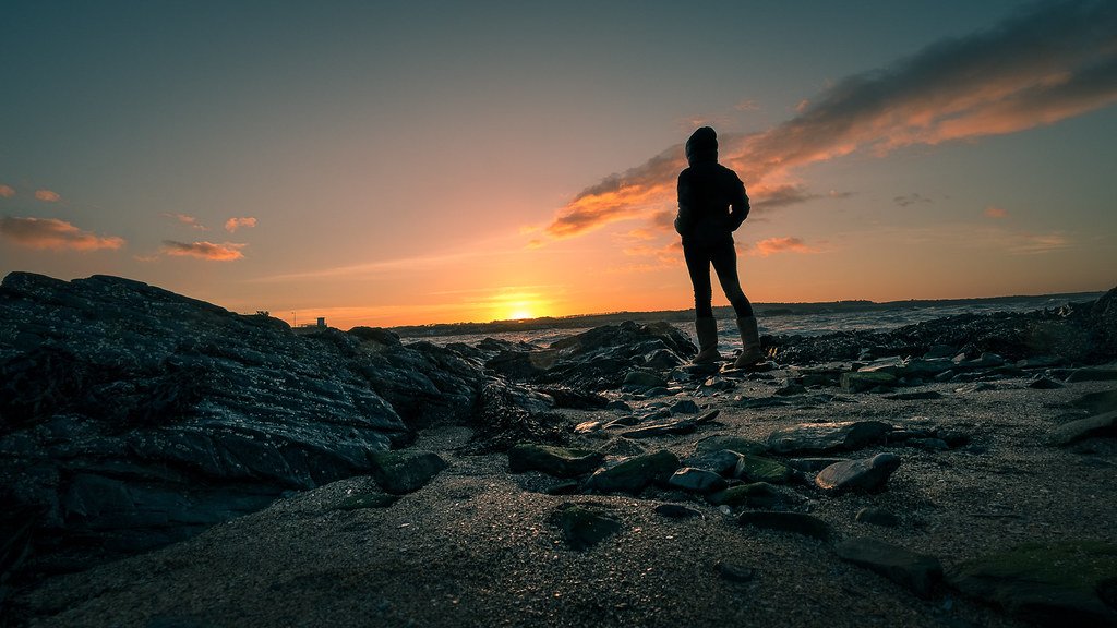
Somewhere beneath the grey, choppy waters of the North Sea lies a ghost. Not the kind that haunts old houses, but an entire vanished landscape, complete with rivers, forests, hills, and the footprints of people who walked there thousands of years ago. It’s one of those stories that sounds almost too dramatic to be real.
This submerged territory, known as Doggerland, is slowly giving up its secrets thanks to cutting-edge science and a growing community of researchers obsessed with piecing together what life looked like before the waters swallowed everything. What they’re finding is genuinely astonishing. Let’s dive in.
A Landscape That Disappeared Without Warning
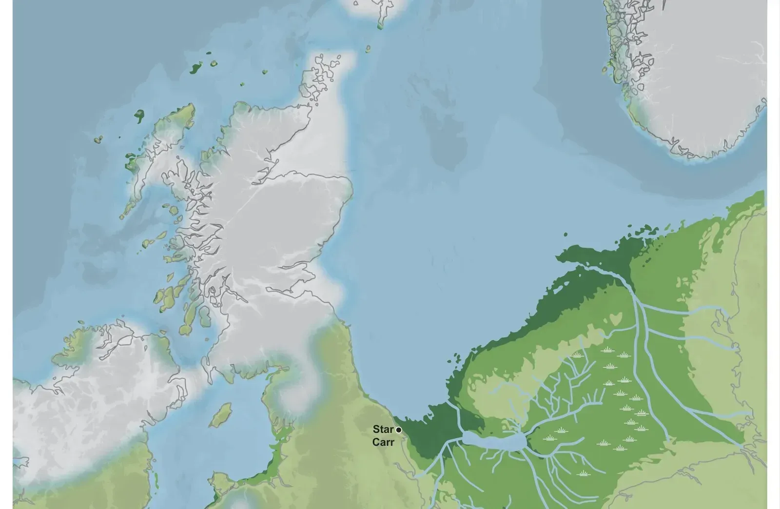
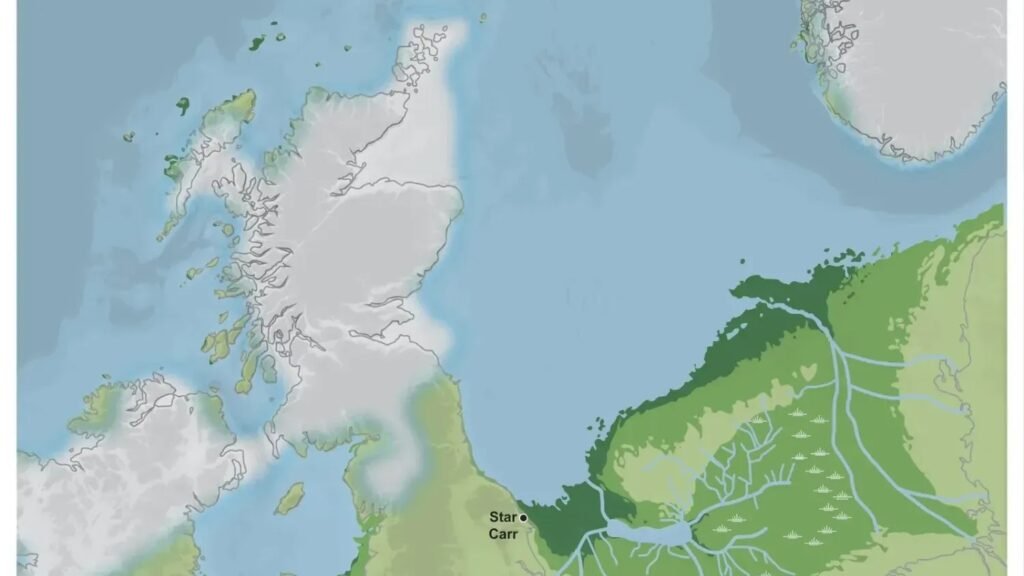
Roughly eight thousand years ago, a vast and fertile landmass connected what is now Britain to mainland Europe. We’re talking about an area comparable in size to a significant chunk of Western Europe, filled with rolling grasslands, wetlands teeming with wildlife, and river systems that would have been perfect for human settlement. It wasn’t a barren wasteland. It was, by all accounts, a paradise.
The land didn’t vanish overnight in one dramatic moment, though the end was catastrophic. Rising sea levels following the last Ice Age were gradually encroaching, but the final blow came from a massive underwater landslide off the coast of Norway called the Storegga Slide. This triggered a tsunami that likely swept across the low-lying land, displacing whatever communities remained and accelerating the region’s submersion.
What Scientists Are Now Discovering Below The Waves
Here’s the thing about underwater archaeology: it’s incredibly difficult, expensive, and time-consuming. Yet researchers have been making remarkable progress using seismic survey data, originally collected by the oil and gas industry, to map the ancient terrain beneath the seabed. Think of it like using an X-ray to see the skeleton of a buried world.
Recent studies have identified ancient riverbeds, peat deposits, and even what appear to be traces of human activity preserved in sediment cores pulled from the seafloor. Peat, in particular, is exciting because it preserves organic material extraordinarily well. Bones, plant material, and artifacts can survive for millennia in these oxygen-poor layers, giving scientists a genuine window into a world that has otherwise been lost.
Who Actually Lived There and How Did They Survive
The people who inhabited Doggerland were Mesolithic hunter-gatherers, skilled, adaptable, and deeply connected to the land and water around them. They hunted large game, fished the rivers and coastal areas, and gathered plants across a diverse and resource-rich environment. Honestly, life there probably wasn’t all that different from other thriving communities of the same period across Europe.
Evidence suggests the population could have numbered in the tens of thousands at its peak. That’s not a small, isolated group of wanderers. These were established communities with knowledge of their environment passed down through generations, living on land that the sea would eventually reclaim completely. It’s hard not to feel something when you sit with that thought.
The Role of Climate Change in Doggerland’s Fate
Let’s be real: the story of Doggerland is, at its core, a story about climate-driven environmental change and what happens when sea levels rise beyond what a landscape or its inhabitants can absorb. After the last Ice Age ended, global temperatures climbed and massive ice sheets melted, pouring unimaginable volumes of water into the world’s oceans. The seas rose steadily, relentlessly.
For the people of Doggerland, this wasn’t an abstract concern mapped on a graph. It was the slow disappearance of coastlines, fishing grounds, and eventually entire settlements over the course of generations. Some researchers believe the communities would have retreated gradually, migrating eastward and westward as the waters crept in. Others suspect some groups held on much longer than expected, clinging to higher ground that became islands before vanishing entirely.
Dogger Bank: The Last Remnant of a Sunken World
If you’ve ever heard of Dogger Bank, the famously rich fishing ground in the North Sea, you’re actually already familiar with the last surviving trace of Doggerland. Dogger Bank is essentially a shallow underwater plateau that was once the highest terrain of this lost landmass. In ancient times it would have been a prominent upland area, perhaps used by communities as a seasonal camp or meeting point.
Trawler fishermen working these waters for generations have accidentally pulled up some extraordinary finds, including mammoth bones, ancient tools, and even fragments of what appears to be worked wood. These are objects that no wave or current deposited there. They’re relics left behind by people who once stood on dry ground in the exact same spot where fishing boats now bob on the surface. That’s a genuinely strange thing to contemplate.
Technology Is Finally Unlocking Doggerland’s Secrets
The real game-changer in recent years has been the application of sophisticated 3D seismic imaging technology to reconstruct what Doggerland actually looked like. Researchers have been able to identify ancient river valleys, lake beds, coastal lagoons, and elevated ridges with a level of detail that simply wasn’t possible even a decade ago. It’s a bit like watching a blurry photograph slowly come into focus.
Combined with environmental DNA sampling from sediment cores, scientists can now begin identifying what kinds of plants and animals lived in specific areas of the landscape at different time periods. This builds up a remarkably rich ecological picture. It transforms Doggerland from an abstract concept into a real, textured place with its own distinct geography and biodiversity. The research is still in relatively early stages, but the momentum is real and the discoveries keep coming.
Why Doggerland Matters More Than Ever Today
There’s an uncomfortable parallel sitting right at the heart of the Doggerland story. A habitable, populated landmass was gradually and then catastrophically lost to rising seas driven by climate change. Today, scientists estimate that hundreds of millions of people globally live in low-lying coastal areas facing increasing flood risk as sea levels continue to rise due to human-driven warming. The scale is obviously different, but the mechanism is hauntingly familiar.
Studying Doggerland isn’t just an archaeological exercise in nostalgia. It’s a chance to understand how ecosystems transform, how communities respond to environmental pressure, and what the real human cost of sea level rise looks like across generations. The people of Doggerland adapted as long as they could, then their world disappeared beneath the water. Understanding their story with as much clarity and respect as modern science allows feels, to me, like something genuinely important. What does it tell us about ourselves that we’re only now starting to listen?