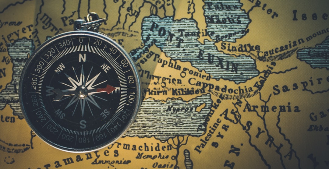
Somewhere just offshore, a ship’s helmsman watches the compass card twitch like a startled bird, then settle on a heading that doesn’t match the coastline at all. The chart is right, the sky is clear, and yet the needle refuses to obey. Stories like this stretch from the age of sail to the age of satellites, and they nearly always point to the same culprit: Earth’s restless magnetism. Today, scientists map these quirks with instruments far more precise than any mariner’s dial, but the allure of places where compasses misbehave remains irresistible. The mystery isn’t supernatural – it’s geological, planetary, and vividly human.
The Hidden Clues
What throws a compass off its game is often hidden underfoot: rocks loaded with magnetic minerals that lock in the memory of ancient fields. When lava cools or sediments settle, iron-rich grains can align with Earth’s field and keep that imprint for millions of years, a property known as remanent magnetization. Stack enough of those rocks in one patch of crust and you build a local tug on the needle, a fingerprint that overlays the planet’s broader field. To a hiker, it might look like a harmless ridge; to a compass, it’s a persistent nudge that whispers, this way instead. Geophysicists chase these nudges with magnetometers, turning puzzles into maps that reveal buried structures, from volcanic dikes to hidden ore bodies. I still remember standing on a dark basalt outcrop and watching my handset heading stutter, as if the rock itself were quietly arguing with the sky.
Field Notes: Australia’s Magnetic Island

Just off northeastern Australia, Magnetic Island earned its name after early navigators reported odd compass behavior near its shores. The island’s bedrock contains magnetite-bearing rocks that can locally skew a needle by several degrees, a tiny angle to the eye but a real headache when you’re threading a channel. Sailors today tend to lean on chartplotters and satellite fixes, yet many still keep a wary eye on the analog card when passing the headlands. Kayakers and hikers sometimes notice smartphone headings spinning or drifting until the devices are recalibrated with a quick figure-eight. The physics isn’t dramatic; it’s simply the nearby magnetic field competing with Earth’s larger, but not always stronger, signal. Places like this turn the landscape into a quiet laboratory where geology and navigation meet in the most practical way possible.
Arctic Drift and High-Latitude Confusion
Far to the north, compasses stumble for a different reason: the field lines plunge steeply toward the planet, starving the needle of the horizontal push it needs. Near the magnetic pole, even a perfect instrument grows sluggish, and the card can wander as if half-asleep. Polar pilots plan around this reality, flying by true bearings, gyros, and satellite guidance rather than trusting magnetism alone. Communities across the high Arctic update their charts and training as declination – the angle between magnetic north and true north – shifts with the pole’s long march across the ocean. On a snowfield or sea ice, where landmarks blur into white, those few degrees can be the difference between a clean approach and a missed destination. The lesson is simple and humbling: at high latitudes, the compass is a suggestion, not a command.
From Ancient Tools to Modern Science

Humanity’s first navigators carried lodestones and crude needles, marveling that invisible forces could point the way home. Today, fluxgate compasses, gyros, and multi-constellation GNSS receivers share the navigation stack, each covering the others’ weaknesses like players on a good defense. Global magnetic models, updated on a regular cycle, fold satellite data and ground observatories into maps that tell you how much to correct your heading anywhere on Earth. Surveyors strap high-sensitivity magnetometers to drones to trace buried faults and old lava flows, turning whispers in the field into crisp contour lines. In the lab, researchers probe tiny diamond defects that act as quantum magnetometers, measuring minuscule variations once lost in noise. The arc from lodestone to quantum sensor isn’t just technological bravado; it’s how we make sense of a planet that never stops moving under our feet.
Global Perspectives on Magnetic Hotspots
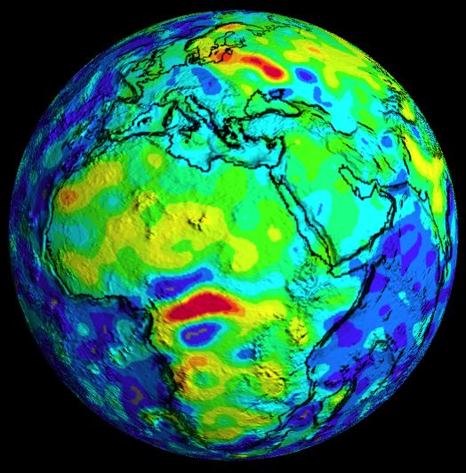
Some anomalies are so large they reshape industries and textbooks. In Russia, the Kursk Magnetic Anomaly reveals an immense iron-rich province that has guided exploration and mining for decades. Across central Africa, the Bangui anomaly puzzles researchers with its size and origin story, a reminder that the crust still holds secrets written in magnetic ink. Out at sea, mid-ocean ridges lay down zebra-striped bands of magnetized basalt, flipping polarity with each reversal of the field and giving plate tectonics one of its most elegant proofs. Volcanic archipelagos like Hawaii or Iceland can host local deviations around young flows, turning a scenic overlook into a point where a compass quietly lies. These places don’t break the rules; they illuminate them, showing how local geology can bend a global field just enough to matter in everyday life.
Why It Matters
It’s tempting to shrug and say that GPS solved navigation, but the world still runs on magnetism more than most of us realize. Aircraft headings, ship routes, and runway labels depend on magnetic bearings, which need regular updates as declination shifts. Pipeline inspectors hunt for corrosion using magnetic flux changes, and utility crews trace buried cables with tuned magnetic fields that keep workers safe. Even your phone’s map app relies on a tiny magnetometer to know which way you’re facing, a fact you rediscover the moment it gets confused and spins you in a circle. Biologists probing animal migration add another dimension, because many species sense the field, weaving magnetism into their suite of cues like stars, scents, and polarized light. When compasses falter, it’s not a niche curiosity – it’s a systems problem that touches safety, infrastructure, and how we orient ourselves in the world.
The Future Landscape

New technology is closing the gap between curiosity and control, giving us tools to predict and work around magnetic quirks. Satellite constellations track field changes in near real time, while ground observatories stream data that feed into models used by pilots and mariners. Ultra-sensitive quantum and diamond-based sensors promise lighter, cheaper surveys, the kind small research teams and even schools can run across beaches, islands, and city parks. Engineers are building navigation systems that refuse to have a single point of failure, blending GNSS, inertial sensors, vision, and magnetics into resilient positioning for drones, cars, and ships. On the policy side, agencies push out declination updates and guidance so airports, harbors, and emergency services stay aligned with reality rather than last decade’s numbers. The likely result is a world where compasses still wobble in odd places, but fewer people are caught off guard when they do.
Conclusion
If you carry a compass – analog or in your phone – get in the habit of checking your local magnetic declination before you head out, and practice calibrating that device until it’s second nature. Support community science by joining local geology walks or school projects that map small magnetic variations in parks and shorelines, turning your neighborhood into a living classroom. Encourage your favorite trails, marinas, and small airports to post updated bearing information, because a few degrees of error can compound quickly in a crisis. If you work in planning or safety, make magnetic updates part of your routine reviews, the same way you’d refresh fire and evacuation plans. And the next time your needle quivers on a rocky headland, take a breath, verify with a second method, and enjoy the rare feeling of sensing the planet’s pulse directly – when was the last time a simple tool let you feel the core of the Earth at work?

Suhail Ahmed is a passionate digital professional and nature enthusiast with over 8 years of experience in content strategy, SEO, web development, and digital operations. Alongside his freelance journey, Suhail actively contributes to nature and wildlife platforms like Discover Wildlife, where he channels his curiosity for the planet into engaging, educational storytelling.
With a strong background in managing digital ecosystems — from ecommerce stores and WordPress websites to social media and automation — Suhail merges technical precision with creative insight. His content reflects a rare balance: SEO-friendly yet deeply human, data-informed yet emotionally resonant.
Driven by a love for discovery and storytelling, Suhail believes in using digital platforms to amplify causes that matter — especially those protecting Earth’s biodiversity and inspiring sustainable living. Whether he’s managing online projects or crafting wildlife content, his goal remains the same: to inform, inspire, and leave a positive digital footprint.