Walking through the concrete jungle of America’s major cities, you step over countless untold stories rushing silently beneath your feet. Every day, millions of people cross ancient waterways that once shaped the landscape, supported wildlife, and determined where early settlers would build their communities. These forgotten underground rivers still flow, carrying with them centuries of history and presenting both challenges and opportunities for modern urban life.
Most cities contain natural streams that have been partially or entirely built over. As cities grew, many of these rivers were paved over and now run underground, becoming subterranean through covering over a river or diverting its flow into culverts. From Manhattan’s bustling streets to San Francisco’s rolling hills, these hidden waterways continue to influence everything from building foundations to flood patterns. Let’s dive into the fascinating world of America’s underground rivers and discover what lies beneath our feet.
New York City’s Vast Network of Buried Streams
In New York City, dozens of streams have been covered over the last two hundred years, with the lineage of many major sewer lines traceable back to streams and rivers that flowed unfettered for centuries. Minetta Creek was one of the largest natural watercourses in Manhattan, filled in by the mid-19th century though it persisted as an underground stream through the 20th century. Sunswick Creek in Queens fell prey to expanding concrete in the late 1800s, now existing only as a meager flow through buried sewer-like pipes.
The East Village contains a mythic maze of subterranean streams that could affect flooding as sea level rises and climate change delivers increasingly intense storms. Engineers still often consult the famous Viele map from 1874, which details various waterways in the city, as buildings are rebuilt since these places face flooding and water-related damage issues.
The Minetta Brook’s Underground Journey Through Manhattan
Minetta Creek was fed from two tributaries, one originating at Fifth Avenue and 21st Street, and the other at Sixth Avenue and 16th Street, joining near Fifth Avenue and 11th Street then taking a southwesterly course. The stream flowed through the western section of Washington Square Park and eventually discharged into the Hudson River near Charlton Street. The strange bend in nearby Minetta Street follows the path of the river, and construction of Electric Lady Studios had to be delayed due to flooding from the river.
To this day, it is disputed whether Minetta Creek actually exists, though in 2012 observers found water in a manhole that “looked too clean for the city sewer,” and there are reports of potholes and flooding in basements along the creek’s route.
Hartford’s Underground River System
In the 1940s, the U.S. Army Corps of Engineers diverted the Park River beneath Hartford, Connecticut, in one of the largest and most expensive projects the Corps had tackled, burying it 30 to 50 feet below the surface where it still runs under the state capitol and main public library. Hartford’s underground river runs beneath the state capitol and Bushnell Park, where Mark Twain once wrote about fishing in its waters before engineers buried it in massive concrete tunnels, and the river still helps prevent flooding during storms.
Today, a few intrepid urban explorers paddle canoes down the buried river, with guides reporting they have seen eels, carp, and stripers in the dark water. City tours sometimes include stops at spots where people can hear the water rushing below.
San Francisco’s Hidden Underground Waterways
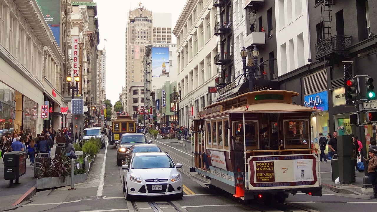
San Francisco has seven celebrated hills but no rivers flowing in the valleys between them, though years ago numerous creeks and streams ran between the undulating topography, springing from grassy hillsides before development buried many of these waterways. Hayes Creek, a large underground waterway, is still flowing beneath San Francisco’s streets today, with BART running de-watering pumps to keep the tracks from flooding.
The Hayes River is a dispersed underground flow that descends through Hayes Valley from hundreds of upwellings near Lone Mountain, averaging about fifteen feet below surface and much deeper and wider than most surface rivers before meeting the surface South of Market. Artists have created walking tours tracing the hidden paths of Islais Creek, Mission Creek, and Yosemite Creek in San Francisco.
Los Angeles Area’s Buried Creek Network
Los Angeles once had an extensive system of creeks and arroyos that crisscrossed the entire city, fed by springs from vast underground aquifers, but today many have been paved over, buried and converted into storm drains, or eliminated altogether. The Arroyo de las Pasas once originated in the hills of Montecito Heights and flowed toward the Los Angeles River, but today much of it is a series of culverts underneath Lincoln Park and the USC Health Sciences Campus.
Even downtown L.A.’s concrete landscape was once home to a willow-lined creek, the Arroyo de los Reyes, which originated north of present-day Echo Park and emerged near what is today Pershing Square. Most Angelenos walk or drive over these buried waterways every day without realizing it, though landscape architect Jessica Hall has traced their former routes through archival research.
Philadelphia’s Mill Creek and Underground Stream Legacy
Over several centuries, most of Philadelphia’s surface streams have been channeled underground and incorporated into the city’s 3,000 mile sewer system, systematically obliterated over the course of the city’s development. Mill Creek was buried in brick sewer pipe in the 1880s and became the focus of the West Philadelphia Landscape Project. Researchers discovered the reality of underground rivers when looking down to see “this big, brown rushing river” with masonry that had fallen in.
The pattern of eastern old cities shows lower-income communities often living in the bottomlands, many literally called the Black Bottom. Changes were made to Philadelphia’s landscape almost as soon as William Penn began building his new city along the Delaware River in 1682.
The Modern Challenges and Opportunities of Underground Rivers
As climate change intensifies rainfall, subterranean waterways become hazardous for cities, with normally quiet underground rivers becoming inundated and causing underground structures such as subways or basements to flood. GIS specialists have begun mapping underground rivers and channels to get a better sense of flood risks within cities, and planners could use such maps to develop urban reservoirs to hold excess water.
Underground rivers face numerous threats from pollution, over-extraction of groundwater that can lower water levels, and climate change altering precipitation patterns. Reversing the burial process is known as “daylighting” a watercourse and is a major form of visible river restoration, where the creek lost the light because it’s under a lid and is now seeing the light again.
Engineering Solutions and Urban Planning Considerations
These streams effectively still run and force careful planning when new buildings are placed, with some streams even found inside buildings in basements where they go through the concrete, and some buildings creating small channels for streams to run through them. Underground rivers still help prevent flooding during storms, while some older buildings use their cool water for air conditioning systems.
Cities plan to unearth brooks through engineering feats known as “daylighting” at costs of more than $130 million, because burying streams in sewer systems has worsened flooding problems as a warming planet experiences more frequent and intense storms. Protecting underground rivers requires concerted effort to manage land use, reduce pollution, and conserve water resources, while revitalization of some waterways along their natural channels could help cities reduce flooding and bring wildlife back.
These hidden rivers beneath America’s major cities represent far more than forgotten history. They’re active geological forces that continue to shape urban life, from building foundations to flood management. Understanding and respecting these underground waterways isn’t just about honoring the past – it’s about creating more resilient, sustainable cities for the future. The next time you walk down a city street, remember that you might be crossing a river that has flowed for thousands of years, patiently waiting beneath the concrete for recognition and perhaps, one day, a return to daylight.
What do you think about these hidden waterways flowing beneath your feet? Tell us in the comments.

Jan loves Wildlife and Animals and is one of the founders of Animals Around The Globe. He holds an MSc in Finance & Economics and is a passionate PADI Open Water Diver. His favorite animals are Mountain Gorillas, Tigers, and Great White Sharks. He lived in South Africa, Germany, the USA, Ireland, Italy, China, and Australia. Before AATG, Jan worked for Google, Axel Springer, BMW and others.


