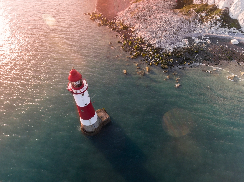
Storms pound the cliffs, kelp forests sway, and surfers skim the surface – yet the most surprising flow along California’s shoreline is out of sight. New research is illuminating a slow, persistent movement of freshened groundwater beneath the beach and seafloor, threading through sand and fractured rock like a ghostly river. It doesn’t roar or sparkle, but it matters, especially as drought cycles tighten and seawater pushes inland. Scientists are piecing together this puzzle with tools that read the subsurface like an MRI, offering a window into a resource we’ve barely recognized. The picture emerging is complex, a mix of ancient water, modern recharge, and tiny pathways that link land to sea.
The Hidden Clues
Imagine freshwater quietly slipping under the surf, moving seaward while waves crash overhead. That unexpected flow first shows itself through subtle signs: cooler patches in beach groundwater, faint chemical fingerprints, and shifts in electrical resistivity that betray fresher fluids below. Onshore wells near the coast sometimes record sudden drops in salinity after big rain years, hinting at pulses moving beneath dunes and piers. Offshore, instruments detect zones that conduct electricity poorly – one of the clearest giveaways of lower-salt water. Add tidal cycles to the mix and the clues sharpen, because daily rises and falls act like a pump that exposes where water is traveling.
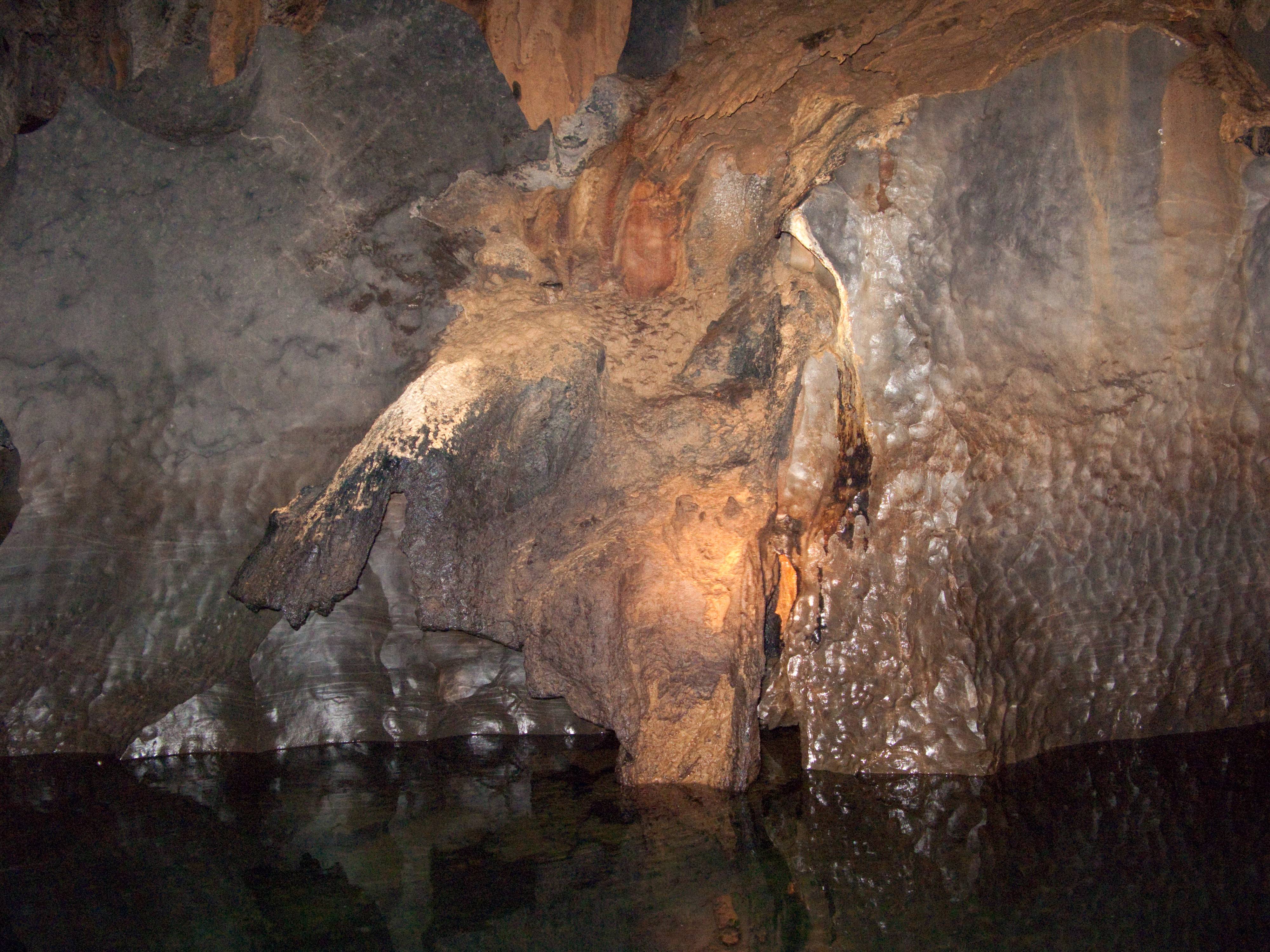
I remember standing on a foggy bluff near Santa Cruz and feeling silly for imagining a river under the ocean – until I saw the data. Once the measurements are laid out, the story becomes hard to ignore: freshwater is down there, not as a single pipe, but as connected pockets and pathways. It threads through buried river channels, beach sands, and faulted layers carved by the coast’s restless geology. The currents are slow, measured in feet or yards per day, but constant. If the surface ocean is a drumbeat, this underworld is a quiet metronome keeping time.
How Scientists Traced Fresh Water Under the Waves
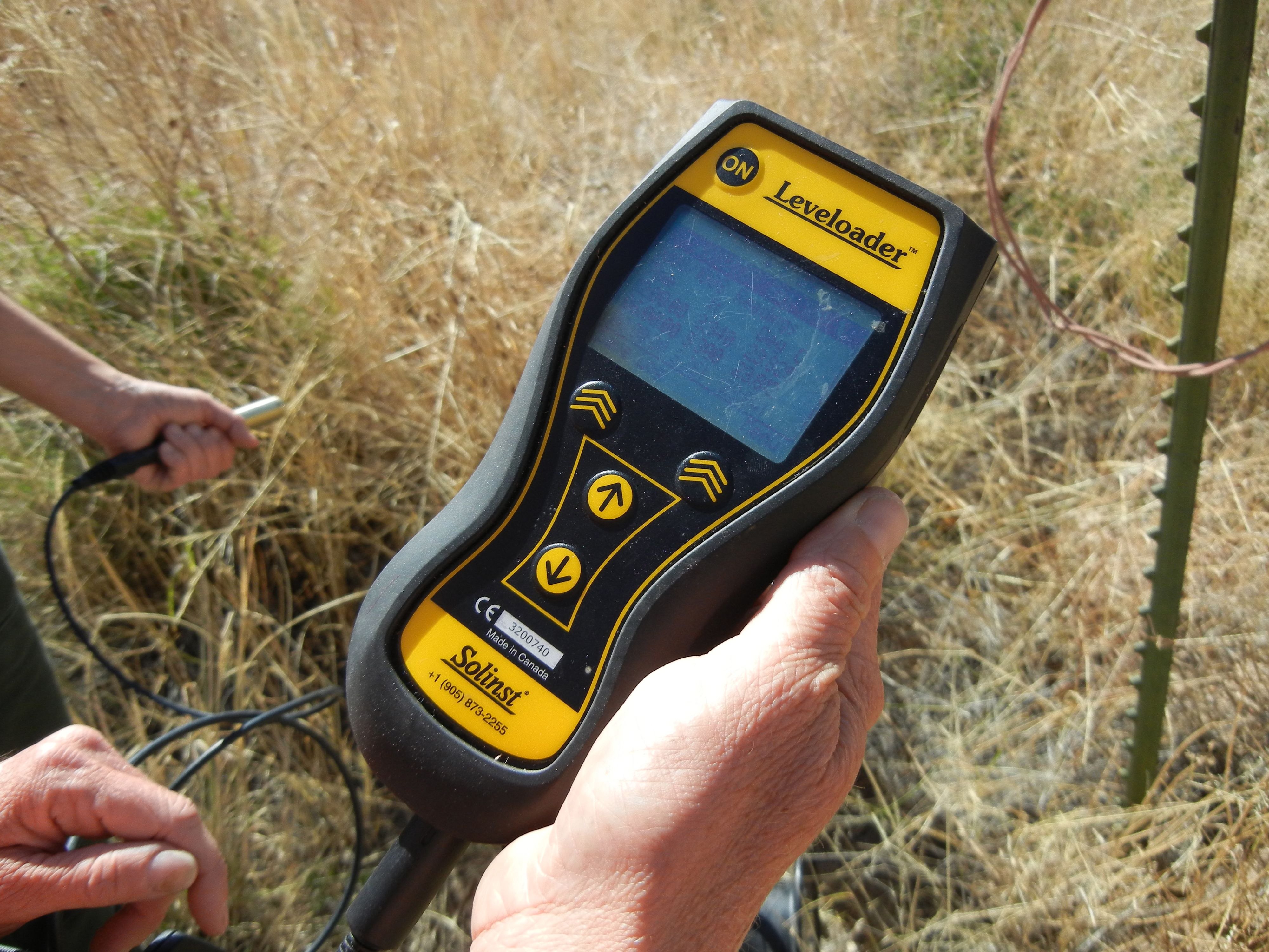
The breakthrough came from listening and from lighting the subsurface in new ways. Controlled-source electromagnetic surveys towed just above the seafloor map electrical resistivity in rich detail, letting researchers identify fresher zones beneath the continental shelf off places like San Diego. Combining those maps with seafloor sonar and seismic reflections reveals buried channels and faults that act like aqueducts and gates. Onshore, teams now repurpose seismic data – originally installed to monitor earthquakes – to track aquifer changes, turning tiny ground vibrations into water-level clues. Airborne and satellite radar add yet another layer, tracing how snowmelt and storms recharge the system that ultimately feeds the coast.
What’s striking is how the methods mesh. Fiber-optic cables act as dense strings of sensors; aircraft-borne instruments sweep miles in a day; and seafloor receivers listen for the faintest whisper of freshened water beneath salt. It’s a hybrid toolkit that finally matches the coastline’s complexity. And with repeated surveys, the hidden river stops being a rumor and becomes a moving picture across seasons and storm cycles. That time-lapse view is exactly what water managers have been missing.
From Ancient Tools to Modern Science
Early hints of undersea freshwater go back decades – odd well logs, beach springs, and the occasional fisherman’s tale of cool seeps. Those observations were patchy, like streetlamps on a dark road. Over the last few years, the lamps multiplied: helicopters slung electromagnetic coils to image aquifers, oceanographers laid out seafloor receivers, and geophysicists trained earthquake networks on water. Even roadway fiber-optic lines became listening posts, capturing aquifer changes after atmospheric river storms.
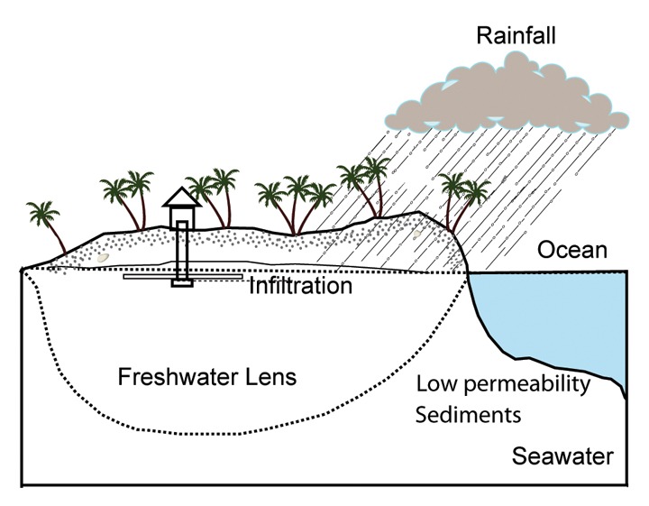
This fusion of methods matters because no single tool can tell the whole story along a coast that toggles between granite headlands and thick, water-holding sediments. The result is a new map that recognizes the shoreline as a living boundary, not a line on a chart. In that view, freshwater doesn’t stop at the beach; it keeps going, tapering off under the shelf in lenses and fingers. The coast, it turns out, is less a wall and more a sieve.
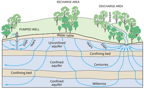
What’s Actually Down There
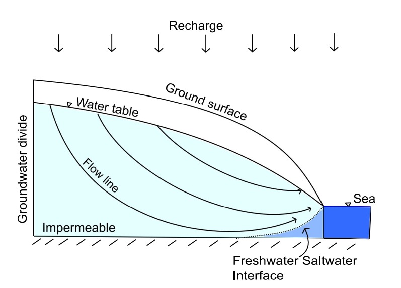
The “river” is really a mosaic: patches of fresh-to-brackish water, some remnants from wetter past climates and some newly recharged during big water years. These patches migrate slowly through permeable layers, guided by buried valleys and nudged by faults that slice the coastal basins. Where freshened zones meet seawater, a subterranean estuary forms, with sharp chemical gradients that shift with the tides and seasons. That mixing zone can be narrow – yards to tens of yards thick – but it can extend for miles alongshore.
Flow rates are modest, and the volumes aren’t an instant cure for drought, but the system still matters. Freshened groundwater beneath the shelf can buffer saltwater intrusion, feeding the coast from below when rivers run thin. Conversely, heavy pumping inland can reverse that flow, letting seawater creep landward. In other words, the hidden river is both a safety net and a warning light, depending on how we treat it.
Why It Matters
For a state that leans on groundwater for about two fifths of its supply in normal years – and nearly three fifths during hard droughts – every hidden ounce counts. Recent wet winters bumped statewide groundwater storage, yet deeper aquifers beneath urban basins lagged behind, reminding us that recovery is uneven and slow at depth. In coastal zones, the undersea freshwater system can act like a pressure valve, pushing back against salt and preserving onshore wells longer than expected. But if we overshoot on pumping or ignore sea-level rise, that same system becomes a pathway for salinity to move inland.
There’s also a water-quality dimension. The subterranean estuary is a biochemical workshop where microbes filter nutrients and transform pollutants before they reach the surf. If we alter the flow – by paving recharge zones, for instance – we change the chemistry at the shore. So the stakes are practical and immediate: drinking water reliability, agricultural resilience, coastal ecosystem health, and billions in infrastructure riding on what happens below the tide line.
Human Stories at the Water’s Edge
Walk the back streets of a beach town after a king tide and you’ll meet the problem face to face: puddles that linger where the ground is already saturated from beneath. In some neighborhoods, the water table rises and falls with the ocean, inching closer to basements, sewer laterals, and buried cables. The hidden river isn’t just a scientific curiosity; it’s part of why storm drains back up and why salt pops up in shallow wells that used to run sweet. It’s also why planning departments now ask about groundwater as well as waves.
Farmers on coastal terraces feel it too. A wet winter can sweeten shallow wells for a season, but a hot, dry summer tips the balance back toward salt. Small agencies are experimenting with winter recharge basins and recycled water injection to bolster freshwater heads near the coast. Those projects aren’t flashy, yet they’re the kinds of nimble fixes that can keep the undersea buffer intact while buying time for bigger, slower investments inland. When I talk to local managers, what I hear most is urgency paired with realism.
Global Perspectives
California isn’t alone in discovering freshened water under the shelf; similar reserves have been mapped from the U.S. Northeast to other continental margins. The physics are consistent: past low sea levels, river channels now buried, and modern recharge pushing seaward through permeable layers. What varies is the geology, the rate of extraction on land, and the management discipline at the coast. Where pumping is controlled and recharge is encouraged, the subterranean estuary holds its own and even pushes salt back toward the sea.
These comparisons are more than trivia. They show that the hidden river is a global phenomenon with local rules, and that governance – boring as it sounds – sets the direction of flow as surely as geology. Lessons from one shoreline can help another choose the right blend of monitoring, recharge, and restraint. California, with its mix of innovation and pressure, is an ideal test bed. If we get it right here, others will take note.
The Future Landscape
What’s next is sharper vision and smarter guardrails. Expect more seafloor electromagnetic surveys stitched into coastal models, autonomous robots towing instruments along canyon walls, and fiber-optic listening lines on piers to catch daily changes in the mixing zone. Airborne radar will keep tracking where snowmelt actually sinks in, aligning mountain recharge with coastal needs months later. Machine learning will crunch these layers into near-real-time risk maps that tell cities where to harden pipes, where to lift streets, and where a modest recharge project would do the most good.
Policy will need to catch up. Clear rules on tapping any offshore freshened zones, strict protections for the microbial filters in beach aquifers, and steady investment in onshore recharge will determine whether the hidden river stays fresh. The technical hurdles are solvable; the social ones are harder – sharing costs, curbing overdraft, and planning around a water table that moves. In a hotter, drier West, treating this subsurface flow as part of the water portfolio is simply pragmatic. The ocean will keep tugging; our job is to give freshwater enough pushback to hold the line.
Conclusion
Start local: ask your city or water district how they monitor coastal groundwater levels and whether their flood maps include rising water tables. Support projects that capture winter runoff for recharge and back efforts to use purified recycled water to keep freshwater heads up near the coast. If you’re a homeowner, consider permeable landscaping and rain gardens that nudge more water into the ground instead of gutters. Community groups can sponsor well sampling days or help deploy low-cost sensors that track salinity and tide-driven groundwater swings.
For the science-curious, attend a groundwater agency meeting or volunteer with coastal monitoring programs to see the instruments and data yourself. And when bond measures or rate changes surface, weigh them against the quiet reality underfoot: a hidden river that protects wells, neighborhoods, and ecosystems when we give it the right conditions to flow seaward.

Suhail Ahmed is a passionate digital professional and nature enthusiast with over 8 years of experience in content strategy, SEO, web development, and digital operations. Alongside his freelance journey, Suhail actively contributes to nature and wildlife platforms like Discover Wildlife, where he channels his curiosity for the planet into engaging, educational storytelling.
With a strong background in managing digital ecosystems — from ecommerce stores and WordPress websites to social media and automation — Suhail merges technical precision with creative insight. His content reflects a rare balance: SEO-friendly yet deeply human, data-informed yet emotionally resonant.
Driven by a love for discovery and storytelling, Suhail believes in using digital platforms to amplify causes that matter — especially those protecting Earth’s biodiversity and inspiring sustainable living. Whether he’s managing online projects or crafting wildlife content, his goal remains the same: to inform, inspire, and leave a positive digital footprint.