Weather has always been unpredictable, though our modern forecasting systems make it feel manageable most of the time. Yet beneath this veneer of meteorological understanding lies a collection of phenomena that continue to confound even the most brilliant atmospheric scientists. You might think we’ve figured out all the basic mechanics of our skies by now, living in an age where satellites track every cloud and computer models predict storms days in advance.
Think again. Nature still keeps some of its most spectacular secrets locked away, producing events so strange they sound like fiction. These aren’t just rare occurrences that happen once in a blue moon. They’re recurring mysteries that challenge our fundamental understanding of physics and atmospheric science. So let’s dive into the most puzzling weather phenomena that still leave scientists scratching their heads.
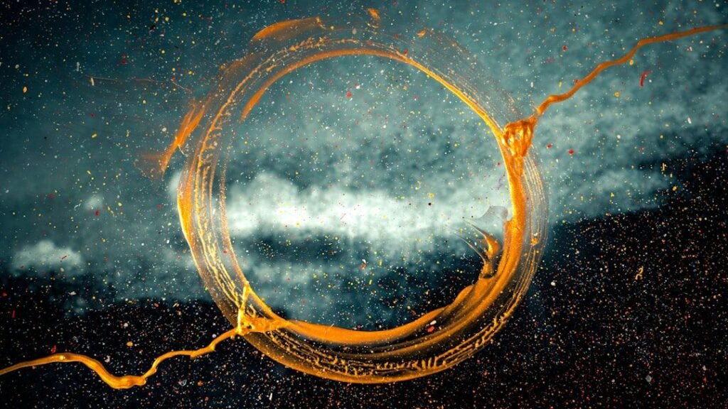
Ball Lightning: The Floating Mystery That Defies Physics
Picture yourself in your living room during a thunderstorm when suddenly a glowing sphere the size of a basketball floats through your window. Ball lightning is a rare and unexplained phenomenon described as luminescent, spherical objects that vary from pea-sized to several meters in diameter. Though usually associated with thunderstorms, the observed phenomenon is reported to last considerably longer than the split-second flash of a lightning bolt, and is a phenomenon distinct from St. Elmo’s fire and will-o’-the-wisp.
Scientific data on ball lightning remains scarce. Although laboratory experiments have produced effects that are visually similar to reports of ball lightning, how these relate to the phenomenon remains unclear. Theories abound: Ball lightning is the result of a failed lightning bolt, of hot ionized silica, or of chains of charged particles. One paper even proposed that ball lightning came from magnetic stimulation in the brain.
The Morning Glory Clouds That Roll Across Australian Skies
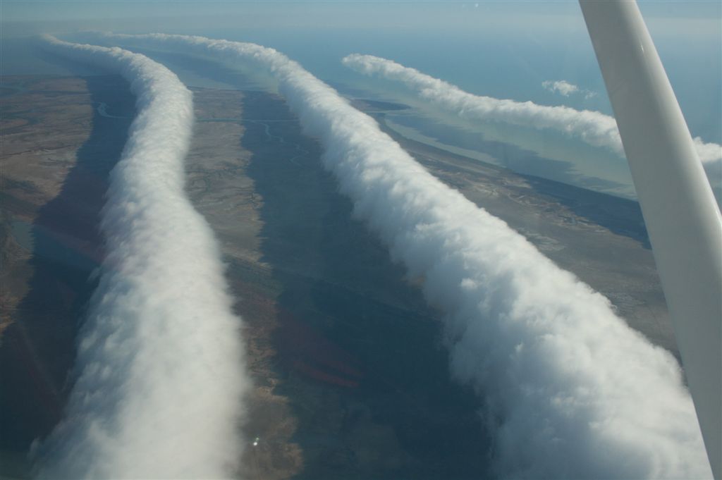
The Morning Glory cloud is a rare meteorological phenomenon consisting of a low-level atmospheric solitary wave and associated cloud, occasionally observed in different locations around the world. The wave often occurs as an amplitude-ordered series of waves forming bands of roll clouds. The southern part of the Gulf of Carpentaria in Northern Australia is the only known location where it can be predicted and observed regularly due to the configuration of land and sea in the area.
A Morning Glory cloud is a roll cloud, or arcus cloud, that can be up to 1,000 kilometres (620 mi) long,1 to 2 kilometres (0.62 to 1.24 mi) high, often only 100 to 200 metres (330 to 660 ft) above the ground. The cloud often travels at the rate of 10 to 20 metres per second. Despite extensive research into this phenomenon, there is still no scientific consensus regarding its formation. However, it is considered to be closely related to the high pressures that predominate in northern Australia.
Heat Bursts: When Night Becomes a Furnace
Imagine waking up at midnight to discover the temperature has suddenly spiked by twenty degrees and hurricane-force winds are tearing through your neighborhood. Though a rare phenomena, that’s the power of a heat burst. Heat bursts occur in the wake of dying thunderstorms, but other conditions have to be just right – the storm has to be high in the atmosphere and the air beneath must be hot and dry.
When the storm rains into this arid environment, the water quickly evaporates. Evaporation takes heat energy out of the surrounding air and causes it to cool and contract, so we end up with a very dense parcel of air too heavy to stay up. It begins to fall through the atmosphere, and the quicker it’s losing heat, the quicker it falls. This phenomena is most common in late spring and summer at night, since most thunderstorms expend their energy during the daytime.
Thundersnow: Lightning’s Winter Performance
Snow falling peacefully from the sky is one thing, thunder and lightning during a blizzard is quite another. Lightning flashing and thunder roaring in the middle of a snowstorm sounds like a weather anomaly dreamed up by a rock band. Thundersnow is rare, dramatic, and incredibly loud. Imagine a blizzard mixed with a thunderstorm – a perfect soundtrack for the apocalypse.
Thundersnow is most common in the Great Lakes region of the United States, where it occurs about 2 to 3 times per year! The phenomenon requires very specific conditions that atmospheric scientists are still working to fully understand. The combination of heavy snow and electrical activity creates a surreal experience that few people witness in their lifetime.
Ice Bombs: Mysterious Chunks Falling from Clear Skies

Wouldn’t you be surprised when hit by a huge hailstorm on a cloudless day? Scientifically known as mega cryometeors, there have been reports of around 50 ice bombs since the turn of century. One in Brazil weighed about 50 Kg. The process that creates these ice bombs is still not completely understood.
These mysterious chunks of ice fall from apparently clear skies, sometimes weighing dozens of pounds. They’ve damaged roofs, cars, and left scientists puzzled about their origin. Unlike hail, which forms in thunderstorms, these ice masses appear with no accompanying severe weather. The lack of a clear formation mechanism makes them one of meteorology’s most baffling mysteries.
Mammatus Clouds: The Sky’s Upside-Down Bubbles
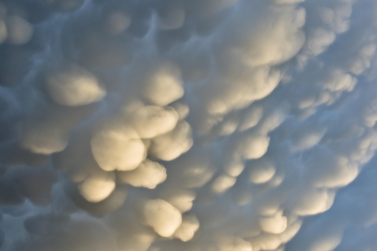
Take a look at these looming, upside-down bubbles of cloud hanging from a dark sky. These are mammatus clouds – protruding lobes often found suspended from thunderclouds. They can occur across various cloud types, adding to the mystery of their formation. Despite their ominous look, mammatus clouds do not always signify severe weather. Researchers continue to study their formation to better understand what atmospheric conditions produce this phenomenon.
Each bulge of mammatus forms as this cold, dense air falls earthwards, dragging the moisture it holds with it. As it does so, the air warms and the moisture evaporates, marking the bottom of the cloud. They create an otherworldly appearance that photographers treasure, yet scientists still debate the precise mechanisms behind their formation.
Animal Rain: When Frogs and Fish Fall from the Sky
Fish rains and frog storms are real events caused by waterspouts that suck up aquatic life and dump it far from home. Imagine stepping outside and finding trout flopping on your front porch. In 1947, after a devastating storm, The Library of Congress reported that fish fell in a town in Louisiana. In more recent history, in 2005, people in Serbia reported thousands of frogs falling from the sky.
These are not the only two cases of animal rain. There have been multiple reports of similar events happening, dating all the way back to ancient civilizations. Though this may seem like something out of the Bible, there is a scientific reason why this may occur. Waterspouts can indeed lift small animals and deposit them elsewhere, though the exact dynamics remain partially mysterious.
The Brocken Spectre: Your Shadow’s Giant Ghost
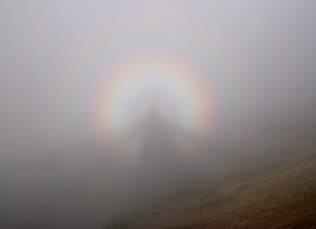
The Brocken Spectre is a phenomenon that occurs when a person standing on a mountain or at high altitude sees their shadow cast onto a cloud. What makes it eerie is that the shadow appears much larger than the person, often surrounded by a halo-like ring of light, known as a “glory.” This optical illusion occurs under specific conditions, such as when the sun is low behind the observer and a mist or cloud is in front.
While scientists understand the basics of light refraction and the observer’s shadow creating the image, the full dynamics of why the shadow appears so large are still not fully known. This ghostly phenomenon has spooked mountain climbers for centuries and continues to mystify atmospheric physicists studying optical phenomena.
Ice Circles: Nature’s Perfect Spinning Disks

Ice circles are perfectly round formations that appear on the surface of lakes or rivers during cold weather. These disks of ice can rotate slowly, giving them an eerie, otherworldly appearance. While scientists have proposed that they form due to a combination of cold air, water flow, and the Coriolis effect, the exact mechanics are still not fully understood.
They have been observed in various parts of the world, from Scandinavia to North America, often in remote or quiet areas. Their size can vary from a few feet to over 50 feet in diameter, and their near-perfect symmetry adds to the mystery. Despite attempts to replicate them in controlled environments, their formation in nature remains unpredictable. Researchers continue to explore how water currents and air temperature contribute to these unusual formations.
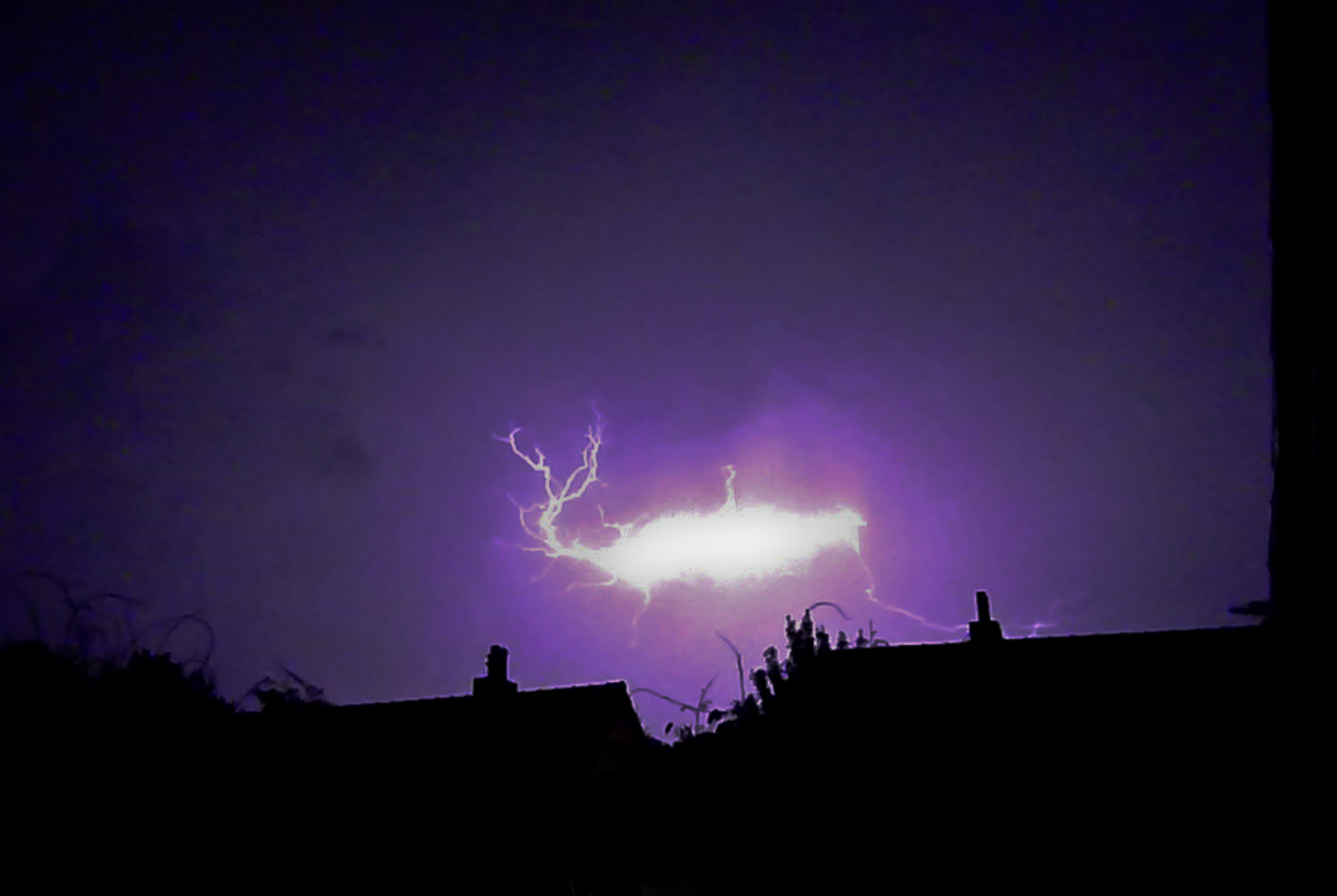
Sprites: The Mysterious Lightning Above the Clouds
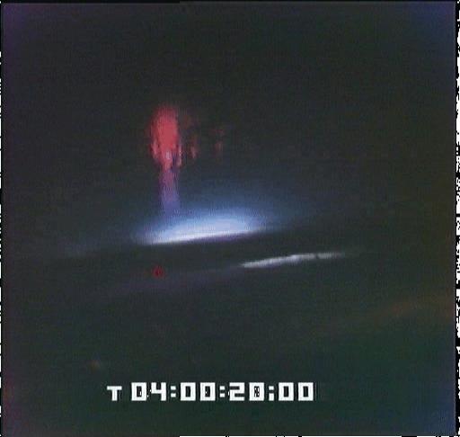
Sprites are rarely captured on camera because they happen in the atmosphere more than 31 miles above the Earth, per BBC’s Science Focus. To balance the positive lightning charges that come out of the bottom of a storm cloud, sprites occur above a thundercloud. Red sprites are a rare phenomenon which is not very well understood. They can occur out of the top of very powerful thunderstorms, and only last for a fraction of a second.
These towering electrical discharges stretch upward from storm clouds into the mesosphere, creating brief flashes of red and orange light. Their discovery was relatively recent, and scientists are still working to understand the electrical processes that create these high-altitude phenomena that look almost alien against the night sky.
Virga: The Rain That Never Falls

Virga is ghostly precipitation that never makes it to the ground. When the air beneath a cloud is very dry, precipitation falling through it evaporates before reaching Earth’s surface. This weather phenomenon is known as virga. It occurs when rain falls from a cloud but evaporates before it reaches the ground. It can create stunning visual effects as the rain falls through the air.
The evaporation process takes a lot of energy out of the surrounding air and causes it to cool. That cold air may then sink very quickly and dump a dangerously concentrated parcel of air and water/hail in a microburst. What appears as harmless hanging curtains of mist can actually precede dangerous downdrafts that pose significant risks to aviation.
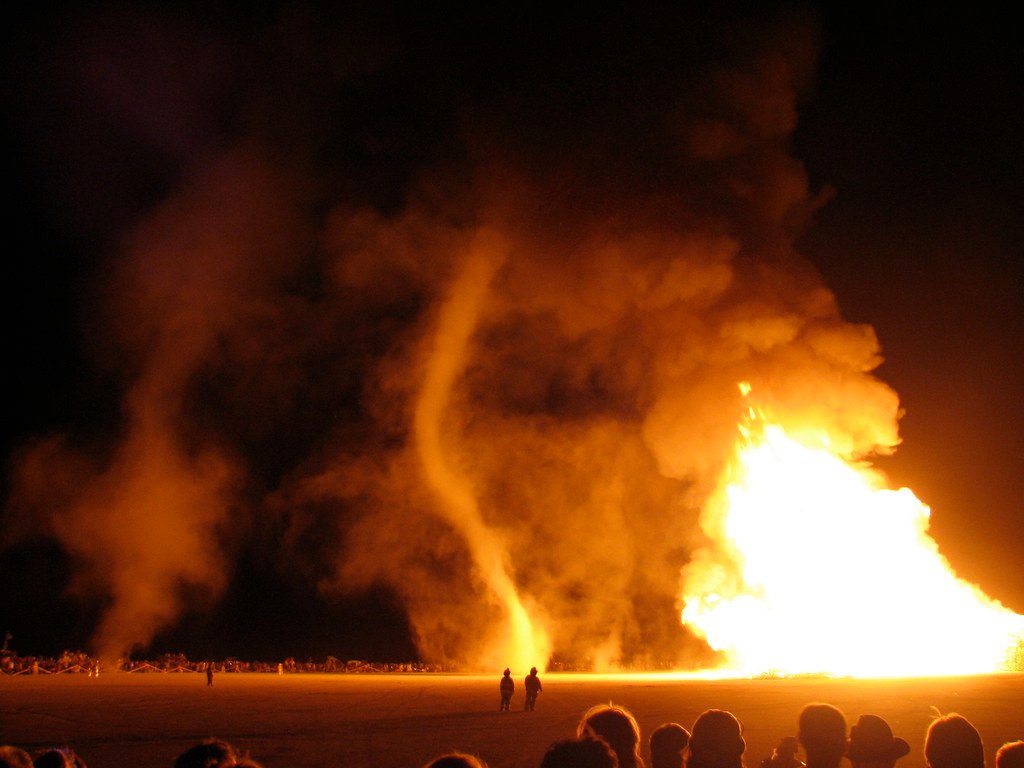
Fire Whirls: Tornadoes That Dance with Flames
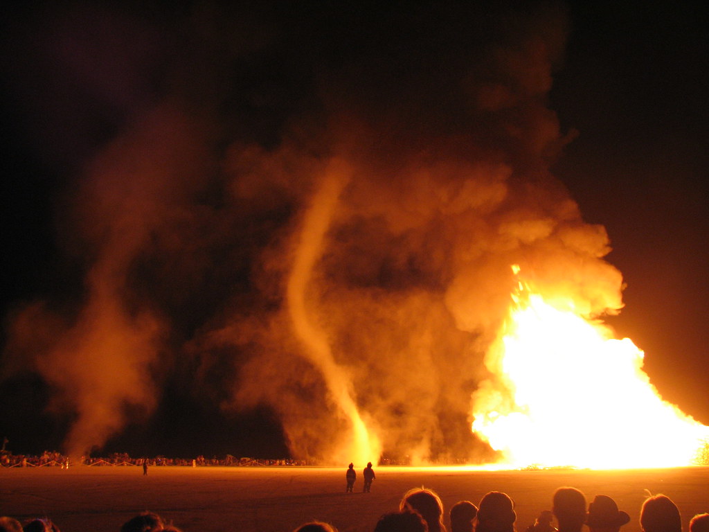
Fire tornadoes (or ‘fire whirls’, to give them their correct name) are most common in large-scale wildfires, and are not actual tornadoes but vortices that suck in gases and combustable materials. They can last an hour or more, and the temperature inside them can reach over 1,000 degrees inside.
Sometimes you might even see a much smaller fire whirl form on small bonfires and have also been created and studied in science labs across the world. These spinning columns of flame can reach heights of several hundred feet and move unpredictably across landscapes, making them both fascinating and terrifying natural phenomena that challenge our understanding of fluid dynamics in extreme conditions.
The Conclusion: Nature’s Ultimate Mysteries

Despite these advances, Vautard said “major mysteries remain”. What’s clear is that nature still holds plenty of mysteries, and these weather phenomena remind us just how little we understand about the forces shaping our planet. Even with our sophisticated satellites, computer models, and atmospheric research, the skies above continue to produce events that defy complete explanation.
These bizarre weather phenomena serve as humbling reminders that our planet’s atmosphere remains largely mysterious. From glowing spheres that float through thunderstorms to perfect ice circles spinning on frozen lakes, nature continues to surprise us with displays that challenge the boundaries of scientific understanding. What’s your take on these atmospheric mysteries? Have you ever witnessed any unexplained weather events that left you wondering what forces were at play above your head?

Jan loves Wildlife and Animals and is one of the founders of Animals Around The Globe. He holds an MSc in Finance & Economics and is a passionate PADI Open Water Diver. His favorite animals are Mountain Gorillas, Tigers, and Great White Sharks. He lived in South Africa, Germany, the USA, Ireland, Italy, China, and Australia. Before AATG, Jan worked for Google, Axel Springer, BMW and others.