A Gusty Start to Friday (Image Credits: Fox2now.com)
St. Louis – Colder air has begun infiltrating the region following the departure of recent storms, carried by strong westerly gusts.[1]
A Gusty Start to Friday
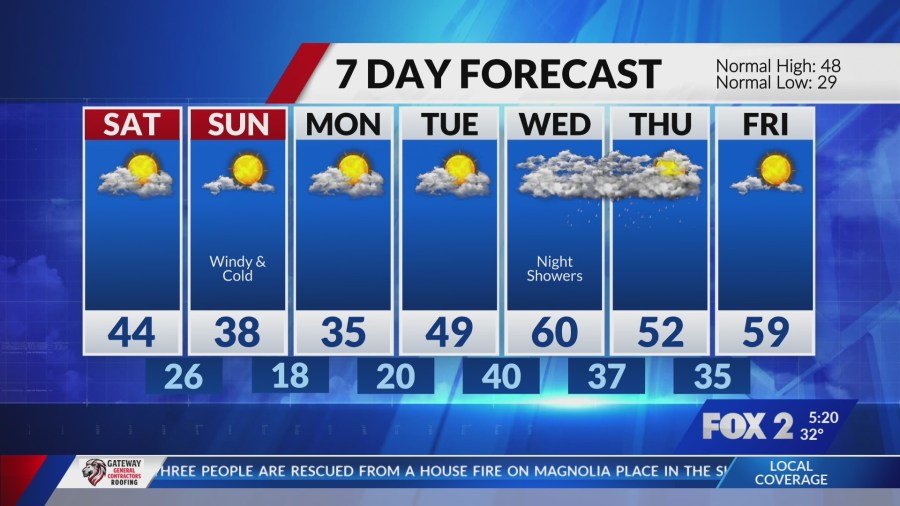
A powerful wind gust reached 44 mph at Lambert Airport around 2 a.m. Friday, signaling the arrival of brisk conditions.[1] Winds between 30 and 40 mph persisted through the morning hours. These gusts gradually diminished during the afternoon. The blustery weather marked a stark shift from earlier stormy patterns.
Local observers noted the rapid change as clearer skies emerged. Such winds often accompany cold fronts in the Midwest during late winter. Friday’s display served as a preview of the weekend’s cooler tone.
Sunny Skies for Friday Amid Cooling Trend
Residents enjoyed sunny conditions Friday, though temperatures topped out in the low to mid-40s.[1] This marked a noticeable drop from prior warmth. Breezy westerlies contributed to the chill factor throughout the day.
The pleasant sunshine provided a brief respite before further cooling. Highs in this range felt seasonable for February but cooler than recent days. Many took advantage of the clear weather for outdoor activities.
Light Snow Showers Possible Early Saturday
A weak weather system tracked across the southern U.S. overnight Friday into Saturday, bringing potential for isolated snow showers.[1] These flurries could appear after midnight south of Interstate 70. Brief bursts might extend through 6 a.m. Saturday. Accumulations remained negligible due to warm ground temperatures from earlier mild weather.
Impacts from any snow proved minimal. Roads stayed mostly dry. The event highlighted the region’s variable winter patterns. Forecasters emphasized little disruption to morning commutes.
Cold Deepens Across the Weekend
Saturday brought clearing skies and chilly air, with highs again in the low to mid-40s.[1] Conditions felt brisk under lingering northwest flow. Sunday introduced returning gusty winds and even colder readings, with daytime highs dipping into the 30s.
Monday continued the cold before a gradual warm-up ensued. The weekend shift underscored typical late-winter volatility in St. Louis.
| Day | High (°F) | Low (°F) | Conditions |
|---|---|---|---|
| Friday | Low-Mid 40s | N/A | Sunny, gusty |
| Saturday | Low-Mid 40s | N/A | Clearing, chilly; light snow early |
| Sunday | 30s | N/A | Gusty, cold |
- Gusts up to 44 mph early Friday at Lambert Airport.[1]
- 20% chance of snow late Friday night per National Weather Service.[2]
- Highs near 43 Friday, per NWS forecast.[2]
- Minimal snow accumulation expected south of I-70.[1]
- Winds easing Friday afternoon.
Key Takeaways:
- Colder air dominates after storms, with gusts peaking early Friday.
- Few snow showers early Saturday, no major impacts.
- Temperatures drop further Sunday into the 30s.
The weekend forecast reminds St. Louisans of winter’s lingering bite, even as spring approaches. What are your thoughts on this cool-down? Share in the comments below.