Cloudy but Mild Thursday Conditions (Image Credits: Fox2now.com)
St. Louis – A weak weather system drifting southeast from Iowa ushers in mostly cloudy skies on Thursday, setting a calm tone for the end of the workweek ahead of rain expected Saturday.[1]
Cloudy but Mild Thursday Conditions
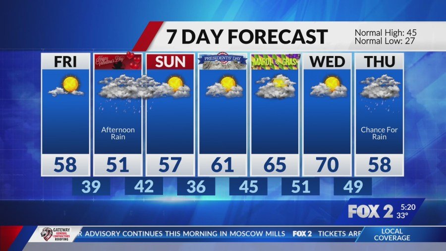
The departing storm system from Iowa produced rain and snow farther north but delivers only thicker cloud cover to the St. Louis area today. High temperatures climbed into the low 50s under overcast skies, keeping conditions comfortable yet subdued. Overnight lows dipped into the low to mid-30s, maintaining a chilly feel after sunset.
Southeast winds around 9 mph added a light breeze, with precipitation chances holding at just 10 percent. This setup avoided any disruptions, allowing for routine outdoor activities despite the gloom.[2]
Friday Brings Welcome Sunshine
Clearer conditions emerge Friday as high pressure builds in, offering mostly sunny skies and warmer readings. Daytime highs reach the upper 50s, with lows around 40 degrees overnight. Precipitation odds drop to zero percent, promising a dry and pleasant close to the workweek.
South-southeast winds ease to 7 mph, enhancing the mild atmosphere. Commuters and those wrapping up errands benefit from the improved visibility and comfort levels.[2][1]
Saturday Rain Disrupts Weekend Plans
A new system approaches from the southwest Saturday morning, gradually building rain coverage through the afternoon. Expect wet conditions from noon into the evening, with totals potentially affecting Valentine’s Day events and local Mardi Gras parades. Highs cool to the low 50s, accompanied by 50 percent rain chances and east-southeast winds at 8 mph.
The rain tapers off overnight, leaving behind damp grounds for Sunday. Lows settle near 38 degrees as clouds linger.[2][1]
| Day | High/Low (°F) | Precip Chance | Conditions |
|---|---|---|---|
| Thursday, Feb. 12 | 52/34 | 10% | Cloudy |
| Friday, Feb. 13 | 58/40 | 0% | Mostly sunny |
| Saturday, Feb. 14 | 51/38 | 50% | Rain likely PM |
| Sunday, Feb. 15 | 58/36 | 20% | Partly cloudy |
Data compiled from local forecasts.[2][1]
Extended Outlook Signals Warming Trend
Sunday shapes up drier with partial clearing and highs rebounding to 58 degrees. A warming pattern follows into next week, pushing temperatures higher amid low rain threats. Residents should prepare for variable weekend weather while anticipating milder days ahead.
Key factors include shifting winds and incoming moisture Saturday, but no severe threats appear on the horizon.
Key Takeaways
- Enjoy dry, sunny Friday after Thursday’s clouds.
- Grab umbrellas for Saturday’s afternoon rain.
- Warmer air returns Sunday, extending into next week.
St. Louis transitions smoothly from midweek calm to weekend variability, reminding everyone to check updates for outdoor plans. What are your weekend arrangements in this forecast? Share in the comments.