Overnight Close Call Clears, Leaves Slick Roads (Image Credits: Fox2now.com)
St. Louis – Residents breathed a sigh of relief as the Winter Weather Advisory lifted early Monday, but a prolonged period of rain and thunderstorms now dominates the forecast through the weekend.[1][2]
Overnight Close Call Clears, Leaves Slick Roads
Temperatures hovered between 34 and 36 degrees Fahrenheit overnight, preventing widespread ice accumulation despite a mix of rain, sleet pellets, and snowflakes.[1] Heavier precipitation tapered off before sunrise, though wet conditions persisted into the morning commute. Drivers encountered slick spots on untreated roads, urging caution amid cloudy skies.
Officials canceled the advisory as warmer air took hold, shifting focus from winter hazards to persistent moisture. Current readings showed light drizzle and fog around 35 degrees with east winds at 13 mph, dropping the wind chill to 26 degrees.[2] Visibility dipped to three miles in some areas, complicating early travel.
Monday Greets City with Chilly Drizzle
Cloudy conditions blanketed the region Monday, with highs reaching only the low 40s. Drizzle lingered through mid-morning before easing, keeping surfaces damp under east winds of 7 to 9 mph.[1][2]
Showers picked up later in the evening, carrying a 90 percent chance of precipitation and possible thunderstorms after 3 a.m. Lows settled around 40 degrees overnight, with patchy fog adding to the gloom. This marked the start of an active pattern set to deliver multiple waves of wet weather.
Thunderstorms Build Through Midweek Surge
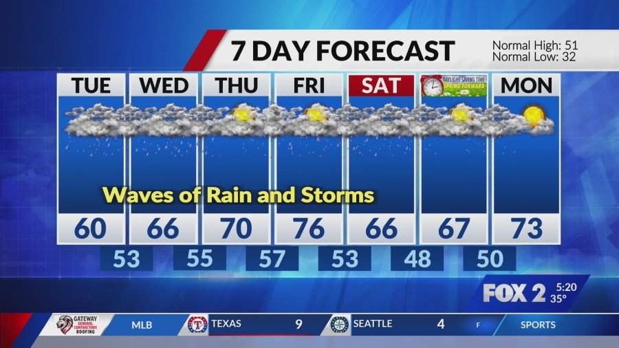
Tuesday brought a sharp warmup, with highs near 63 degrees fueling showers and thunderstorms before afternoon. Precipitation chances hit 90 percent, transitioning to likely showers overnight as lows climbed to 53 degrees.[2] Southeast winds remained light at 6 mph.
Wednesday continued the trend, offering highs near 68 degrees amid 80 percent odds of showers and thunder. Nighttime lows around 55 degrees saw similar risks. Thursday peaked at 70 degrees with 60 percent shower chances mainly before noon, though thunderstorms loomed after midnight. Heavy rain at times raised concerns for localized flooding.
| Day | High/Low (°F) | Precip Chance (%) |
|---|---|---|
| Tuesday | 63/53 | 90 |
| Wednesday | 68/55 | 80 |
| Thursday | 70/57 | 60 |
| Friday | 78/57 | 50 |
Weekend Wetness Persists Amid Warming
Friday highs soared to 78 degrees under partly sunny skies, but 50 percent chances of showers and storms lingered. Saturday cooled slightly to 68 degrees with 60 percent likelihood of showers under cloudy cover. Lows dropped to 47 degrees Saturday night, with odds easing to 20 percent.[2]
Sunday promised highs near 66 degrees and mostly cloudy conditions with similar low shower risks. The pattern highlighted frequent disruptions for outdoor plans, from commuting to weekend events. Residents prepared for ponding on roads and potential stream rises.
Key Takeaways
- Winter Weather Advisory ended; no ice expected as temps rise.
- Multiple rounds of rain and thunderstorms through Saturday, heavy at times.[1]
- Warmup to upper 70s midweek increases storm potential and flood risks.
As St. Louis transitions from winter chill to spring downpours, staying informed remains crucial amid this soggy stretch. Check updates regularly and secure outdoor items before storms arrive. What’s your go-to for beating the rain this week? Share in the comments.