
Friday Builds Heat Before Storm Surge (Image Credits: Unsplash)
St. Louis – A warm and breezy Friday beckons across the St. Louis region, with highs reaching the mid- to upper 80s under a mix of clouds and sunshine. While a slight risk of isolated afternoon showers lingers, the primary concern centers on a line of strong thunderstorms expected to barrel in from northwest Missouri late Friday evening.[1] This stormy front will deliver severe weather threats before paving the way for noticeably cooler conditions over the weekend, a welcome shift after recent mild spells.
Friday Builds Heat Before Storm Surge
The day starts pleasantly enough, with breezy southwesterly winds ushering in a blend of clouds and sun. Temperatures will soar into the mid- to upper 80s, marking a return to summer-like warmth for mid-April. Forecasters note only a marginal chance for pop-up showers or storms during the afternoon hours, keeping most outdoor plans intact until later.[1]
Conditions shift dramatically as evening approaches. Strong thunderstorms are set to ignite over northwest Missouri in the afternoon, organizing into a fast-moving line that tracks southeastward. By approximately 7 p.m., the leading edge will brush the western fringes of the St. Louis metro area, intensifying the watch for residents.[2]
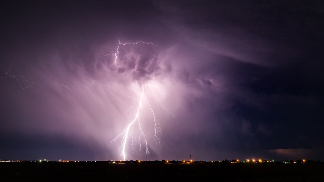
Severe Threats Take Center Stage
The storms carry significant hazards, especially in the northwest corner of the viewing area. Counties such as Montgomery, Gasconade, Pike, Lincoln, and Warren face the highest odds for severe impacts early on. Damaging wind gusts, large hail, and isolated tornadoes top the list of concerns as the line pushes through.[1]
Even as the system weakens slightly while crossing into central St. Louis and southeast Illinois, risks persist into the night. Heavy rainfall could spark isolated flash flooding, while gusty winds exceeding 70 mph and brief spin-ups remain possible. The severe window largely closes around midnight, though pockets of heavy rain may continue overnight.[2]
- Damaging straight-line winds up to 70+ mph
- Large hail in stronger storm cores
- Potential for brief, weak tornadoes
- Heavy rain leading to localized flooding
Affected Areas and Peak Timing
Northwest counties bear the brunt initially, with the Storm Prediction Center highlighting an enhanced risk for widespread severe weather there. The St. Louis metro sees prime time between 8 p.m. and 2 a.m., when wind and tornado threats peak. Southeast Illinois communities should monitor developments as storms exit the region.[2]
Forecasters urge vigilance, particularly for those in rural and western suburbs. The line’s speed means rapid changes, so staying tuned to updates proves essential. No widespread power outages are anticipated yet, but downed trees and limbs remain a hazard in gust fronts.[1]
Weekend Relief on Horizon
Saturday brings a stark turnaround, with clearing skies and temperatures stuck in the 50s – almost chilly after the week’s buildup. Breezes ease, allowing for comfortable recovery from Friday’s drama. Sunday warms modestly into the 60s, setting a milder tone without major precipitation threats.[1]
This cool-down stems directly from the cold front fueling Friday’s storms, sweeping away humid air masses. Outdoor enthusiasts can plan accordingly, though early Saturday showers cannot be ruled out entirely in wake of overnight rains.
| Day | High | Low/Overnight | Key Conditions |
|---|---|---|---|
| Friday | Mid-Upper 80s | Variable (heavy rain late) | Warm/breezy; severe storms evening |
| Saturday | 50s | Chilly | Clearing, cool |
| Sunday | 60s | – | Mild, dry |
Key Takeaways
- Monitor northwest counties Friday evening for peak severe risks.
- Expect winds, hail, and tornado potential until midnight.
- Plan for 50s highs Saturday – layer up after the storm passage.
As the St. Louis region navigates this volatile weather shift, preparation remains key to a safe transition into cooler days. The contrast from Friday’s heat to Saturday’s chill underscores spring’s unpredictability here. What are your weekend plans amid this forecast? Share in the comments below.


