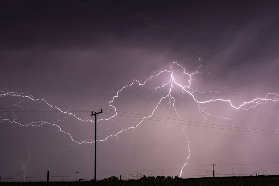
Wednesday’s Storms Wreaked Havoc (Image Credits: Pexels)
Dallas-Fort Worth – Residents across North Texas paused amid scattered showers on Thursday after Wednesday’s punishing storms, as forecasters eyed a more dangerous system barreling in for Friday.[1][2]
Wednesday’s Storms Wreaked Havoc
Heavy downpours hammered the region on March 4, shattering rainfall records at Dallas-Fort Worth International Airport with 1.55 inches—surpassing the 1937 mark of 1.27 inches. Some spots endured even more, including an estimated 8.3 inches in Van Zandt County and 4 to 8 inches near Mesquite, Seagoville, and Wills Point.[1]
Flash flooding prompted high-water rescues in vehicles and homes across those areas, while disabled cars clogged northbound I-45 near Hutchins. A warehouse roof collapsed under water weight in Garland’s 2900 block of Kingsley Road, though seven workers escaped unharmed. Lightning ignited a house fire in Fort Worth, and quarter-sized hail pelted Johnson County south of the metroplex. The National Weather Service issued a Severe Thunderstorm Watch for much of North Texas until 11 p.m., followed by multiple warnings targeting hail up to 1 inch and gusts to 60 mph in counties like Dallas, Tarrant, Ellis, and Kaufman.[3]
Thursday Offers Brief Respite
Conditions eased somewhat today, with isolated to scattered showers and thunderstorms dotting the afternoon landscape. Breezy southerly winds gusted to 30 mph, and temperatures climbed into the 70s and mid-80s—well above seasonal norms.[2]
A River Flood Warning persisted through early Friday morning in Hunt and Rockwall counties. Stronger storms remained possible near the Red River, carrying minor risks of gusty winds or small hail, but no widespread severe threats materialized.[1]
Friday Marks the Peak Threat
Meteorologists flagged Friday as the week’s marquee event, with strong to severe storms firing up in the afternoon and evening, particularly north of the Dallas-Fort Worth metroplex. A robust cold front will fuel the action, elevating all severe weather modes compared to earlier rounds.[2]
Storm coverage could reach scattered levels, though details solidified closer to the date. The setup favors discrete supercells capable of prolonged rotation, heightening tornado potential along and north of U.S. Route 380.[4]
Key Hazards at a Glance
Officials outlined specific dangers for Friday. The National Weather Service Fort Worth/Dallas projected hail up to 2 inches, damaging wind gusts below 75 mph, and a handful of EF0 to EF1 tornadoes.[2]
| Hazard | Expected Intensity | Primary Areas |
|---|---|---|
| Large Hail | Up to 2 inches | North of DFW |
| Damaging Winds | Up to 75 mph | Scattered across North Texas |
| Tornadoes | EF0-EF1 | Along/north of US 380 |
| Flooding | Flash/localized | Saturated soils region-wide |
Flood risks lingered from prior rains on already soaked ground, with heavy downpours in any storm adding to woes. Weekend showers promised further precipitation, though severe odds dropped.[1]
- Monitor local alerts via NOAA Weather Radio or apps.
- Secure outdoor items against high winds.
- Prepare for power outages with flashlights and chargers.
- Avoid flooded roads; turn around, don’t drown.
- Know your safe room for tornado warnings.
Key Takeaways
- Wednesday set rainfall records and caused flash floods, roof collapses.
- Thursday stayed mostly calm with minor showers.
- Friday poses the highest risks: 2-inch hail, 75-mph winds, tornadoes north of DFW.
North Texas entered an active pattern signaling spring’s arrival, demanding vigilance through the weekend. Stay informed and ready—what steps are you taking? Share in the comments below.