
Record Cold Grips the Heartland (Image Credits: Cdn.mos.cms.futurecdn.net)
Frigid Arctic air plunged deep into the United States in late January 2026, driven by a disrupted polar vortex that reshaped winter weather patterns across the Northern Hemisphere.[1]
Record Cold Grips the Heartland
Temperatures plummeted to extraordinary lows as the polar vortex weakened and expanded. In Alliance, Nebraska, the mercury dropped to minus 26 degrees Fahrenheit on January 24, marking the lowest reading for that date on record according to preliminary National Weather Service reports.[1] This extreme chill followed a powerful winter storm that dumped snow and ice across numerous states from the Southwest to New England.
The cold persisted through the week, with dark blue expanses of subzero air spreading south and east in model visualizations. Daily fluctuations appeared as brief pulses amid the broader freeze, highlighting the event’s severity and duration.[1]
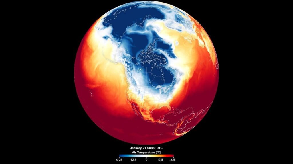
Satellites Illuminate the Atmospheric Drama
NASA’s advanced observing systems captured the unfolding event in vivid detail. Data from satellites fed into the Goddard Earth Observing System model produced an animation spanning January 21 to 29, revealing surface air temperatures over North America and beyond.[1] This blend of observations and simulations showcased physical processes in the atmosphere, from Arctic surges to lingering cold pools.
High-pressure systems forced the jet stream southward, funneling Canadian and Siberian air into eastern North America. Meteorologists noted how this configuration amplified the storm’s intensity, combining polar chill with moisture-laden fronts.[1]
Nationwide Disruptions from the Freeze
The polar vortex’s reach extended far beyond records, straining infrastructure and daily life. Power outages lingered in storm-hit areas, complicating recovery efforts as crews cleared roads and restored services. Wind chills plunged to minus 20 degrees Fahrenheit across the Midwest and Northeast by January 27, even as southern regions began to thaw slightly.[1]
NASA activated its Disasters Response Coordination System to aid response agencies, sharing maps and data on an open portal. Extreme cold warnings covered south-central Texas, where overnight lows hit single digits on January 26.
- Snow and ice blanketed states east of the Rockies.
- Transportation halted amid hazardous conditions.
- Energy demands spiked, challenging grids.
- Health risks rose for vulnerable populations.
- Record minimums shattered in multiple locations.
The Science of Vortex Disruptions
Polar vortices form as rings of strong winds encircling the poles during winter, containing cold air aloft. Sudden stratospheric warmings or other disturbances can split or displace them, allowing outbreaks of Arctic cold at lower latitudes. In this case, the event aligned with a major U.S. storm intensified by ocean influences, as detailed in analyses from climate experts.[1]
Such breakdowns occur periodically but drew attention for their scope in early 2026. Satellite monitoring proved essential, providing forecasters with real-time insights into temperature anomalies and storm evolution. For full details, see the report on the NASA Earth Observatory site.[1]
Key Takeaways
- A weakened polar vortex funneled record Arctic cold into the U.S., peaking January 21-29.
- Satellite-driven models visualized the freeze’s spread, aiding disaster response.
- Impacts ranged from shattered temperature records to widespread power and travel disruptions.
Events like January’s polar vortex remind us of Earth’s dynamic atmosphere and the vital role of space-based observations in safeguarding communities. How did the deep freeze affect your area? Share your story in the comments.