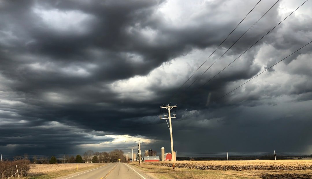
Storms Zero In on High-Risk Corridor (Image Credits: Unsplash)
The Midwest and Ohio Valley endured a fierce assault from severe thunderstorms on March 26, delivering punishing hail and powerful wind gusts to millions. Storms rumbled through key states including Illinois, Indiana, and Ohio, prompting heightened alerts from weather authorities. As the system pushed eastward, a trailing cold front promised a stark temperature reversal across broader swaths of the eastern United States.[1][2]
Storms Zero In on High-Risk Corridor
Thunderstorms ignited late Thursday afternoon near southern Lake Michigan, rapidly organizing into potent clusters ahead of a advancing cold front. The National Weather Service’s Storm Prediction Center elevated the threat to a Level 3 out of 5 across central Illinois, central Indiana, and central Ohio, signaling significant dangers from all severe weather modes. This corridor stretched from Peoria in Illinois through the Indianapolis metro area and much of Ohio toward Pittsburgh.[2]
Nearly 50 million residents faced potential impacts, with major cities like Chicago, Indianapolis, Cleveland, Cincinnati, and St. Louis in the crosshairs. Storms expanded into a linear complex by evening, extending from western Pennsylvania to Kansas City. Heavy rain accompanied the outbursts, raising flash flood concerns from central Illinois to western Pennsylvania.[3]
Hail and Winds Deliver Tangible Damage
Egg-sized hail pelted neighborhoods in Henry County, Ohio, while ping-pong ball-sized stones blanketed Bryan and Sidney in the same state. Reports confirmed hail exceeding one inch in diameter across eastern Illinois, Indiana, and Ohio. Wind gusts reached 65 mph along the storm path, toppling trees and power lines in affected zones.[1]
Damaging winds accounted for most structural disruptions, including downed utility poles and widespread debris. The National Weather Service in Wilmington later verified three tornadoes touching down in Ohio and Indiana amid the chaos. Though an atmospheric cap suppressed widespread twisters, severe thunderstorm warnings blanketed the region as storms persisted overnight.[4]
- Eastern Illinois: Scattered hail and gusty outflows.
- Central Indiana: Peak wind threats near Indianapolis.
- Central Ohio: Largest hail reports, including Jewell and Henry County.
- Western Pennsylvania: Trailing rain and isolated severe pulses.
Cold Front Ushers Dramatic Shift
Behind the volatile weather, the cold front accelerated eastward, slashing temperatures by more than 20 degrees in places like St. Louis. Friday highs plunged into the 40s and 30s across the Midwest, Mid-Atlantic, and Northeast, a sharp departure from prior upper 60s and 70s. This winter-like interlude extended through the weekend’s first half, chilling over 100 million from Maine to South Carolina.[1][2]
Low temperatures dipped into the 20s and 30s Saturday morning over the Midwest and Northeast. Scattered storms lingered into early Friday before weakening, with soaking rains pushing offshore by Saturday. Spring warmth began rebounding Sunday, setting the stage for a gradual warmup through the workweek.
| Region | Pre-Storm Highs | Post-Front Highs |
|---|---|---|
| Midwest | 60s-70s | 30s-40s |
| Northeast | 50s-60s | 40s |
| Mid-Atlantic | 60s | 40s-50s |
Broader Implications and Alerts
The event disrupted daily life, with potential delays for Major League Baseball’s Opening Day contests in Chicago, Cincinnati, and St. Louis. Flash flooding risks lingered overnight, prompting vigilance amid 1-2 inches of accumulated rain. While no widespread tornado outbreaks materialized, the system’s potency underscored early spring volatility in the heartland.[2]
Forecasters noted the jet stream’s strengthening dip over eastern Canada fueled the front’s speed, contrasting a persistent heat dome out west. Marginal severe risks extended to Missouri and Pennsylvania, where isolated storms posed additional hazards.
Key Takeaways
- 50 million at risk from hail up to egg-sized and winds over 65 mph.
- Three confirmed tornadoes in Ohio and Indiana.
- Temperatures dropped 20+ degrees behind the front, affecting 100+ million eastward.
As cleanup efforts begin in storm-weary communities, residents reflect on nature’s reminder of seasonal unpredictability. Warmer conditions loom soon, but this bout highlights the need for preparedness amid shifting patterns. What impacts did you notice in your area? Share in the comments below.