In the space of a single night, the quiet logic of a river can be rewritten. A valley that spent centuries carrying water one way can suddenly send it another, as if a hidden hand tipped the land. Scientists have long known that earthquakes warp the crust, but the speed and scale of the hydrologic chain reaction still feel astonishing. This is the story of rivers that reverse, dams that appear out of nowhere, and channels that abandon their beds for brand-new paths. It’s a mystery with very real stakes for people, wildlife, and the places we call home.
The Overnight Switch: Avulsions Explained
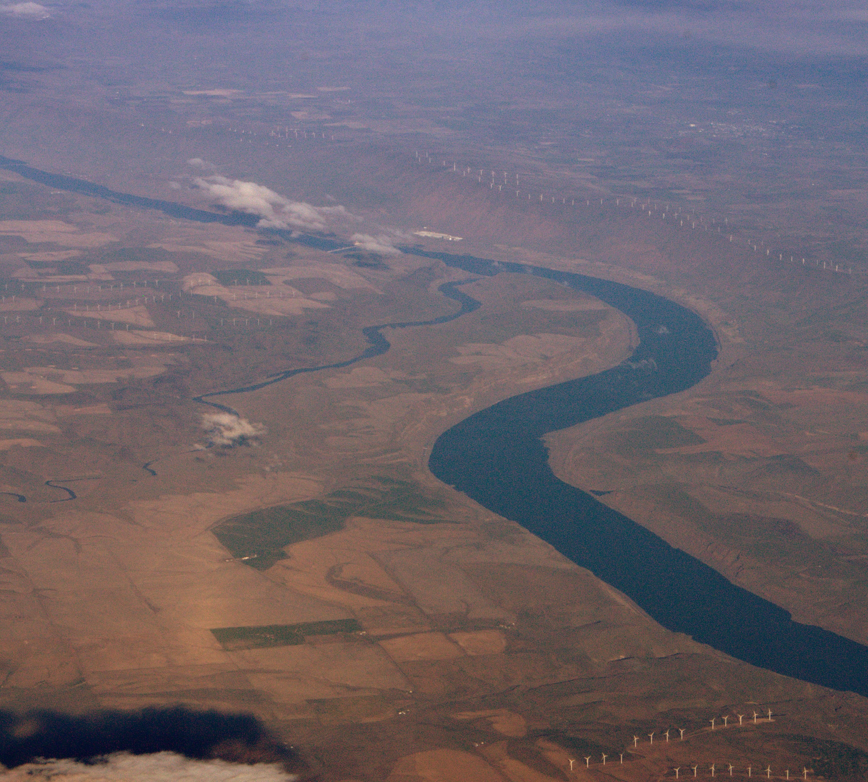
Avulsion is the moment a river jumps its banks and commits to a new course, trading the old channel for a steeper, faster route. Big floods often get the credit, but earthquakes can pull the trigger by tilting the land ever so slightly, making yesterday’s downhill feel a little less downhill. When the gradient advantage flips, a river’s inertia is no match for physics, and water rushes into the path that now delivers the quickest descent.
On rare occasions, the change is dramatic enough to be felt in hours rather than seasons, especially where soft sediments and broad floodplains respond like wet clay. Historical accounts describe temporary reversals on major rivers after powerful shaking, a reminder of how sensitive flow can be to small, sudden shifts in elevation. Once an avulsion starts, sediment piles into the abandoned channel like a door clicking shut, making the new path more permanent than it first appears.
When the Ground Tilts: Uplift, Subsidence, and River Piracy
Earthquakes don’t just shake; they heave, sag, and wrinkle the ground, creating steps and swales that rewire drainage. A few feet of uplift along a fault can strand a river on one side and steepen a competitor on the other, triggering what geomorphologists call river piracy. That’s when one drainage network steals the headwaters of another, capturing flow and sediment, and starving the old course.
Subsidence can be equally disruptive, lowering a valley floor so that water pools and seeks new outlets. Over months, knickpoints – sudden drops in the riverbed – migrate upstream like a moving staircase, accelerating erosion and reinforcing the new direction of travel. The result is a cascading reorganization of watersheds that can redraw hydrologic maps across entire regions.
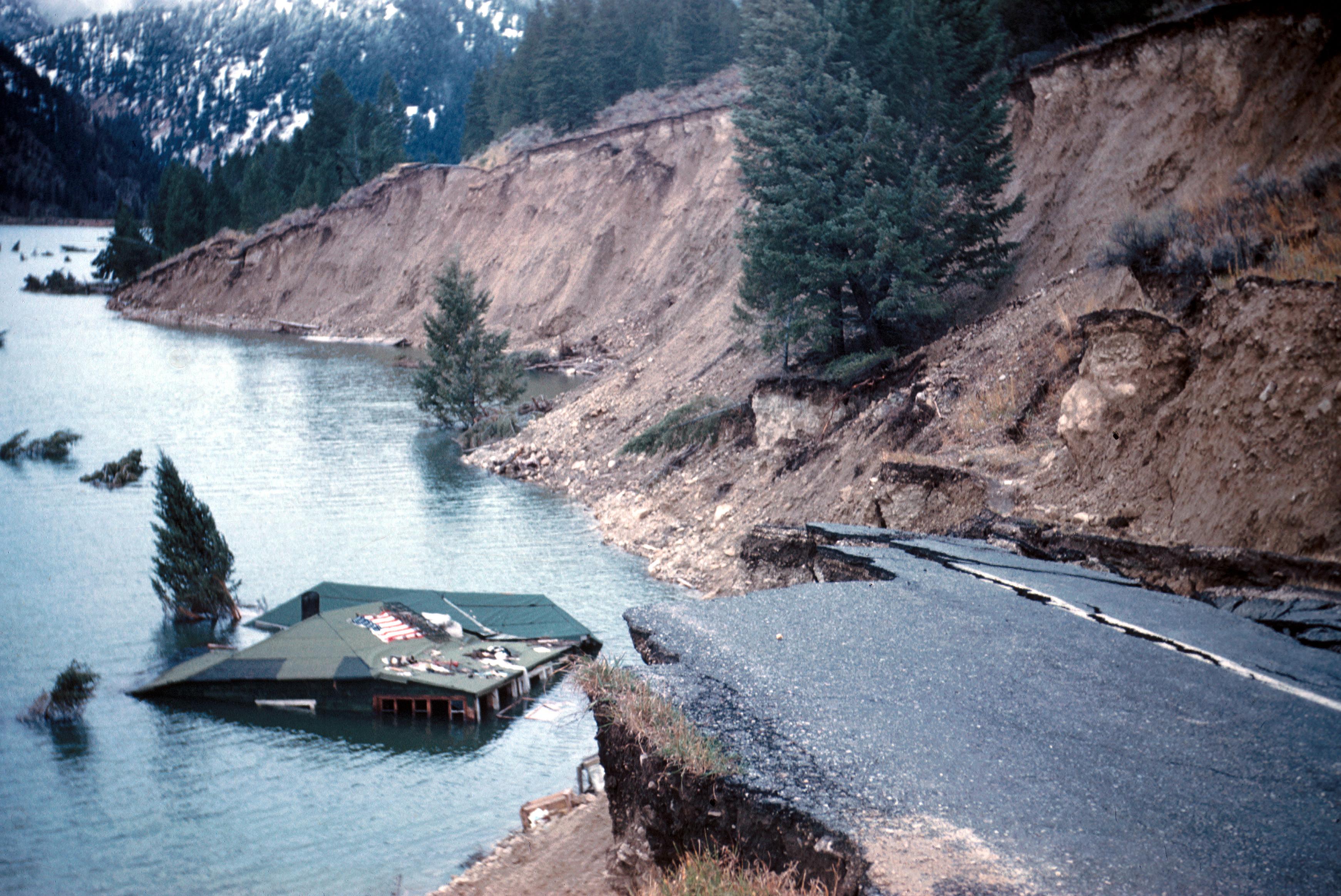
Landslides and Quake Lakes: Dams That Appear in a Day
Strong shaking on steep terrain shakes loose hillsides, sending millions of tons of rock and soil into channels. When these landslides slam into a river, they can build natural dams in minutes, backing up water into newly formed lakes that spread across valleys. Locals sometimes wake to find a calm blue surface where rapids roared the day before.
These barriers rarely last, and that’s the danger: once water overtops or erodes a weak point, a sudden breach can unleash a wall of water and debris downstream. The flood scours banks, obliterates bends, and cuts shortcuts across meanders, often locking in a new channel that bypasses the old one. In a single outburst, the river’s blueprint can be permanently redrafted.
The Hidden Clues
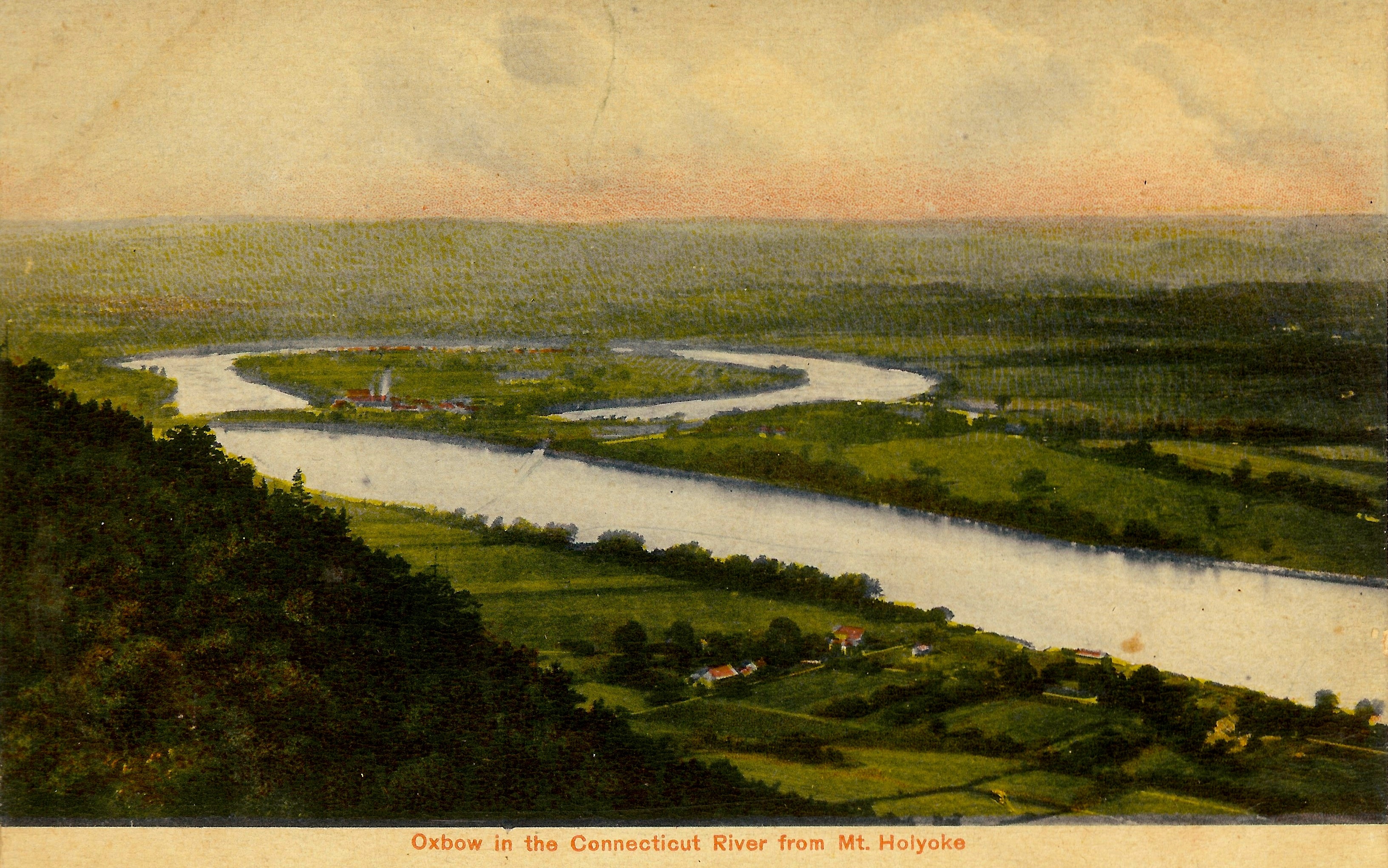
Even when the water looks placid again, the landscape stores a memory of what changed. Abandoned oxbows read like scars, while fresh terraces mark where the river briefly ran higher or lower. Sand sheets on fields and silt draped across backyards tell a forensic story about direction, depth, and velocity.
Fault-parallel ridges, offset gravel bars, and oddly perched wetlands are the quieter clues, the kind that reward a slow walk and a trained eye. I once traced a dry, crescent-shaped depression behind a levee and realized it matched a historic channel that vanished after a quake-triggered flood years earlier. The ghosts of past rivers are everywhere once you know how to look.
From Ancient Tools to Modern Science

Early surveyors used simple levels and river gauges to track changes, but today’s toolkit is astonishingly sharp. Satellites detect millimeters of ground motion with radar interferometry, while GPS arrays record how the crust stretches, kinks, or rebounds during a quake. Aftershock campaigns map hidden faults that quietly tilt basins long after the main event.
Drones stitch high-resolution lidar maps that reveal fresh landslides and subtle channel shifts beneath the canopy. Hydrodynamic models simulate how a few inches of uplift could reroute a river across a floodplain in the next storm. Put together, these tools let scientists move from post-disaster detective work to proactive scenario testing.
Why It Matters
Rivers are lifelines for drinking water, irrigation, fisheries, and transportation, so a sudden reroute is more than a cartographic curiosity. Intake pipes can end up stranded on mud, bridges can find themselves spanning dry channels, and wetlands fed by steady flows can wither. When a natural dam fails, downstream communities face minutes to hours to react, not days.
Compared with slow, climate-driven shifts that unfold over decades, earthquake-driven changes are instant and often irreversible. Planning for that difference means designing flexibility into infrastructure and emergency playbooks that assume the river itself might move. It’s the difference between guarding against high water and preparing for a brand-new river altogether.
Global Perspectives

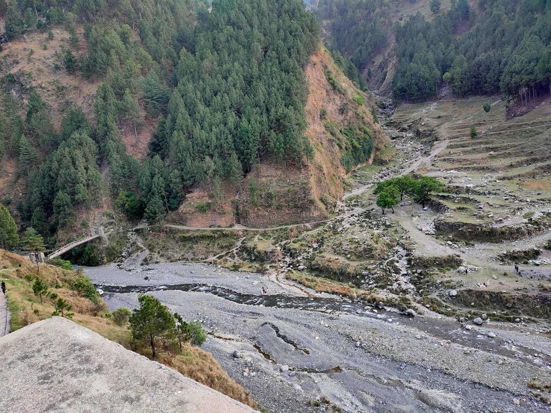
Seismically active mountain belts are hot spots for river reorganizations because steep slopes, abundant sediment, and frequent shaking converge. In such regions, even moderate events can loft hillsides into channels or tilt alluvial fans just enough to redirect flow. Downstream plains feel the consequences as pulses of sediment smother habitats and migrate sandbars.
Elsewhere, coastal zones cope with coseismic subsidence that reshapes tides and backwater zones, letting saltwater push farther inland. Arid basins face the opposite: uplifted outlets trap rare runoff and change the timing of recharge. Every setting has its signature risks, but the thread is the same – fast landscape change with far-reaching hydrologic effects.
The Future Landscape
Forecasting the next river switch hinges on blending real-time sensors with physics-based models that learn from each event. Networks of low-cost accelerometers, river stage gauges, and landslide monitors can now beam data to dashboards that flag dangerous dams forming upstream. Artificial intelligence helps sift satellite imagery for fresh scarps and bulging slopes after big shocks.
The largest challenges are not technical but practical: maintaining sensors in rugged terrain, sharing data across borders, and updating maps quickly enough that responders trust them. Insurance, zoning, and reservoir operations will need to treat channels as dynamic, not fixed lines on a page. The payoff is a future where a midnight quake does not automatically become a dawn disaster.
Conclusion
Start local by learning your watershed: where your drinking water is drawn, which rivers cross fault zones, and how emergency alerts reach you. If you live in quake country, advocate for hazard plans that include rapid river assessments after major shaking, not just building inspections. Support restoration projects that give rivers room to move, since wider floodplains diffuse energy and lower the odds of catastrophic channel jumps.
Back community science efforts that map landslides and high-water marks after storms and quakes, because those observations sharpen models for everyone. Encourage utilities and agencies to design intakes, bridges, and levees that can be adjusted or relocated when channels migrate. A river that can change overnight deserves neighbors who are ready by nightfall.

Suhail Ahmed is a passionate digital professional and nature enthusiast with over 8 years of experience in content strategy, SEO, web development, and digital operations. Alongside his freelance journey, Suhail actively contributes to nature and wildlife platforms like Discover Wildlife, where he channels his curiosity for the planet into engaging, educational storytelling.
With a strong background in managing digital ecosystems — from ecommerce stores and WordPress websites to social media and automation — Suhail merges technical precision with creative insight. His content reflects a rare balance: SEO-friendly yet deeply human, data-informed yet emotionally resonant.
Driven by a love for discovery and storytelling, Suhail believes in using digital platforms to amplify causes that matter — especially those protecting Earth’s biodiversity and inspiring sustainable living. Whether he’s managing online projects or crafting wildlife content, his goal remains the same: to inform, inspire, and leave a positive digital footprint.