
The Awakening of a Dormant Giant (Image Credits: Cdn.mos.cms.futurecdn.net)
A dramatic eruption in Ethiopia has sent plumes of volcanic ash drifting across vast distances, prompting global attention through advanced satellite monitoring.
The Awakening of a Dormant Giant
The Hayli Gubbi volcano, silent for over 12,000 years, burst into activity in late November 2025, marking its first known eruption in millennia. This event caught scientists off guard, as the volcano in Ethiopia’s Afar region had shown no signs of unrest for generations. Seismic activity built up quietly before the explosive release, which propelled ash high into the atmosphere. Researchers from international observatories mobilized quickly to assess the scale, relying on data from multiple sources to track the unfolding phenomenon. The eruption’s intensity surprised even seasoned volcanologists, who noted its potential for widespread atmospheric effects.
As the ash column rose, it began interacting with upper air currents, carrying fine particles far beyond the local area. Initial ground reports described a landscape shrouded in gray, with local communities taking precautions against fallout. The event highlighted the unpredictable nature of volcanic systems in the East African Rift. Monitoring stations detected elevated levels of sulfur dioxide, a key indicator of the eruption’s vigor. This resurgence underscored the importance of ongoing surveillance in geologically active zones.
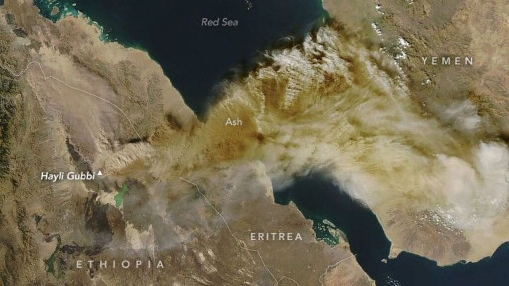
Satellite Eyes Capture the Ash’s Far-Reaching Journey
Advanced imaging from NASA’s Earth Observatory provided a clear view of the ash plume extending over the Middle East by mid-December 2025. These observations, captured on December 16, revealed a vast cloud stretching from Ethiopia toward the Arabian Peninsula. The technology allowed experts to map the plume’s path in real time, showing how winds carried it eastward. Such detailed tracking proved invaluable for predicting dispersal patterns and potential hazards. The imagery emphasized the scale of the event, with the ash layer visible across hundreds of miles.
European Space Agency satellites complemented these efforts, detecting sulfur dioxide concentrations that confirmed the plume’s composition. The combined data helped refine models of atmospheric transport, illustrating how volcanic emissions can influence weather patterns regionally. Analysts noted the plume’s thickness, which posed risks to air quality in affected areas. This level of monitoring has evolved significantly, enabling faster responses to natural disasters. The December images served as a stark reminder of Earth’s dynamic geology viewed from space.
Disruptions from Sky to Ground
The ash spread triggered immediate concerns for aviation across multiple countries, leading to flight cancellations and rerouting in India and parts of the Middle East. Regulatory bodies issued advisories to avoid ash-contaminated airspace, citing engine damage risks from abrasive particles. Ground-level impacts included reduced visibility and potential health issues from inhaling fine ash. Agricultural regions braced for soil contamination, which could affect crop yields in the coming seasons. Emergency services prepared for any escalation, drawing on lessons from past eruptions.
Environmental agencies monitored water sources for acidification due to sulfur compounds in the ash. The event also sparked discussions on climate implications, as volcanic aerosols can temporarily cool surface temperatures. Travel disruptions extended to shipping routes near the Red Sea, where ash fallout complicated operations. International cooperation played a key role, with data sharing between nations to mitigate broader effects. These challenges demonstrated the interconnectedness of global systems in the face of natural events.
Lessons from the Eruption
Volcanologists emphasized the need for enhanced early warning systems following this outbreak, pointing to gaps in real-time data for remote sites like Hayli Gubbi. The eruption offered a rare opportunity to study an ancient volcano’s behavior, providing insights into rift zone dynamics. Collaborative efforts between NASA, the European Space Agency, and local authorities improved forecasting accuracy. Future monitoring will likely incorporate more AI-driven analysis to predict plume trajectories. This incident reinforced the value of satellite technology in disaster management.
- Ash plumes traveled over 2,000 miles, affecting air travel from Ethiopia to India.
- Sulfur dioxide levels peaked, contributing to atmospheric changes.
- Aviation regulators enforced no-fly zones to protect aircraft.
- Local ecosystems faced short-term stress from fallout.
- Global scientific community gained new data on long-dormant volcanoes.
Key Takeaways
- The eruption’s ash reached the Middle East within weeks, visible in satellite data from December 16, 2025.
- Aviation faced widespread disruptions, with cancellations in multiple countries.
- Enhanced monitoring tools proved essential for tracking and response.
As the ash plume disperses, experts continue to watch for lingering effects on climate and air quality, reminding us of nature’s power to reshape skies and routines alike. What impacts have you noticed from recent volcanic activity? Share your thoughts in the comments.

Jan loves Wildlife and Animals and is one of the founders of Animals Around The Globe. He holds an MSc in Finance & Economics and is a passionate PADI Open Water Diver. His favorite animals are Mountain Gorillas, Tigers, and Great White Sharks. He lived in South Africa, Germany, the USA, Ireland, Italy, China, and Australia. Before AATG, Jan worked for Google, Axel Springer, BMW and others.