Weeks of drought in Texas have done something scientists with million-dollar equipment sometimes struggle to achieve: peel back time. As river levels dropped and dusty shorelines cracked open, new dinosaur footprints emerged from the mud, exposing frozen moments from a world more than one hundred million years old. Paleontologists rushed in, not with the attitude of people who had “seen it all,” but with the urgency of detectives stumbling on an unexpected crime scene. What they found is rewriting parts of the story of who lived in this landscape, how they moved, and how our changing climate is uncovering clues at a pace both thrilling and unsettling.
The Hidden Clues Beneath a Drying River
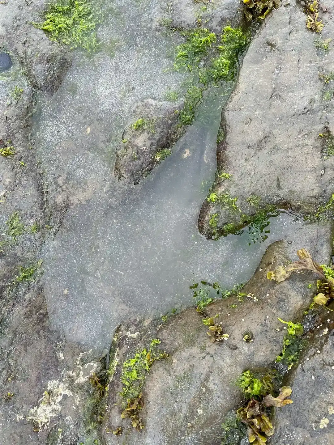
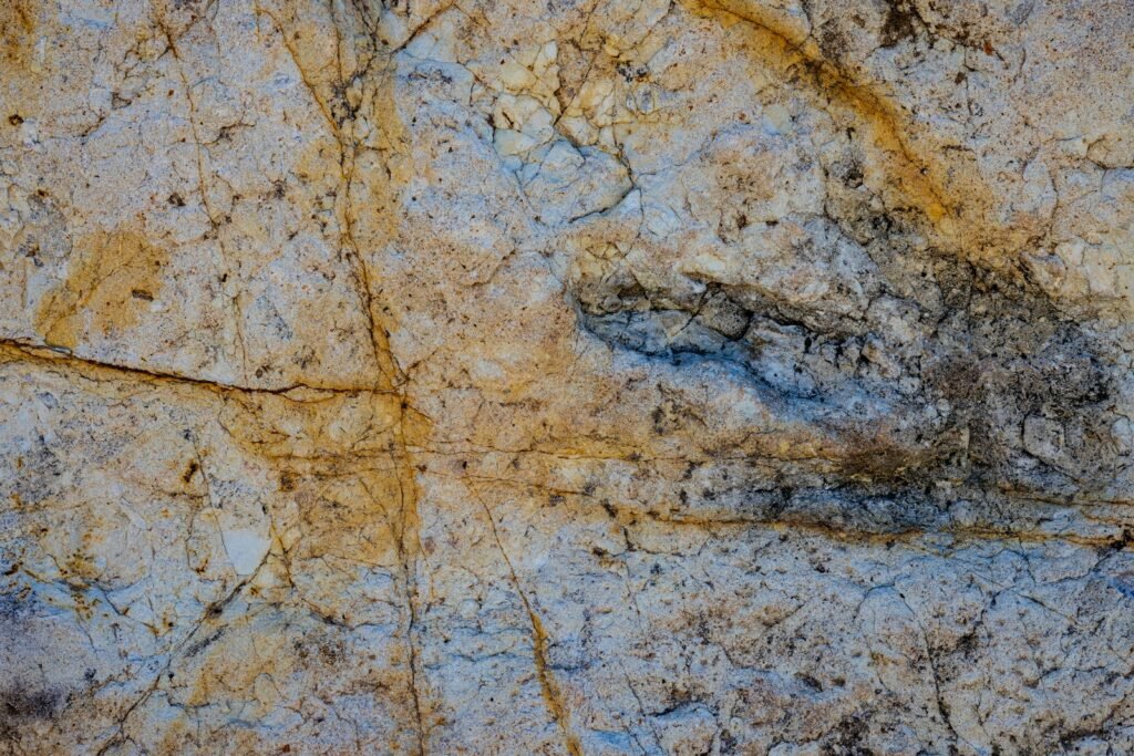
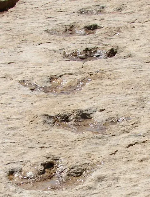
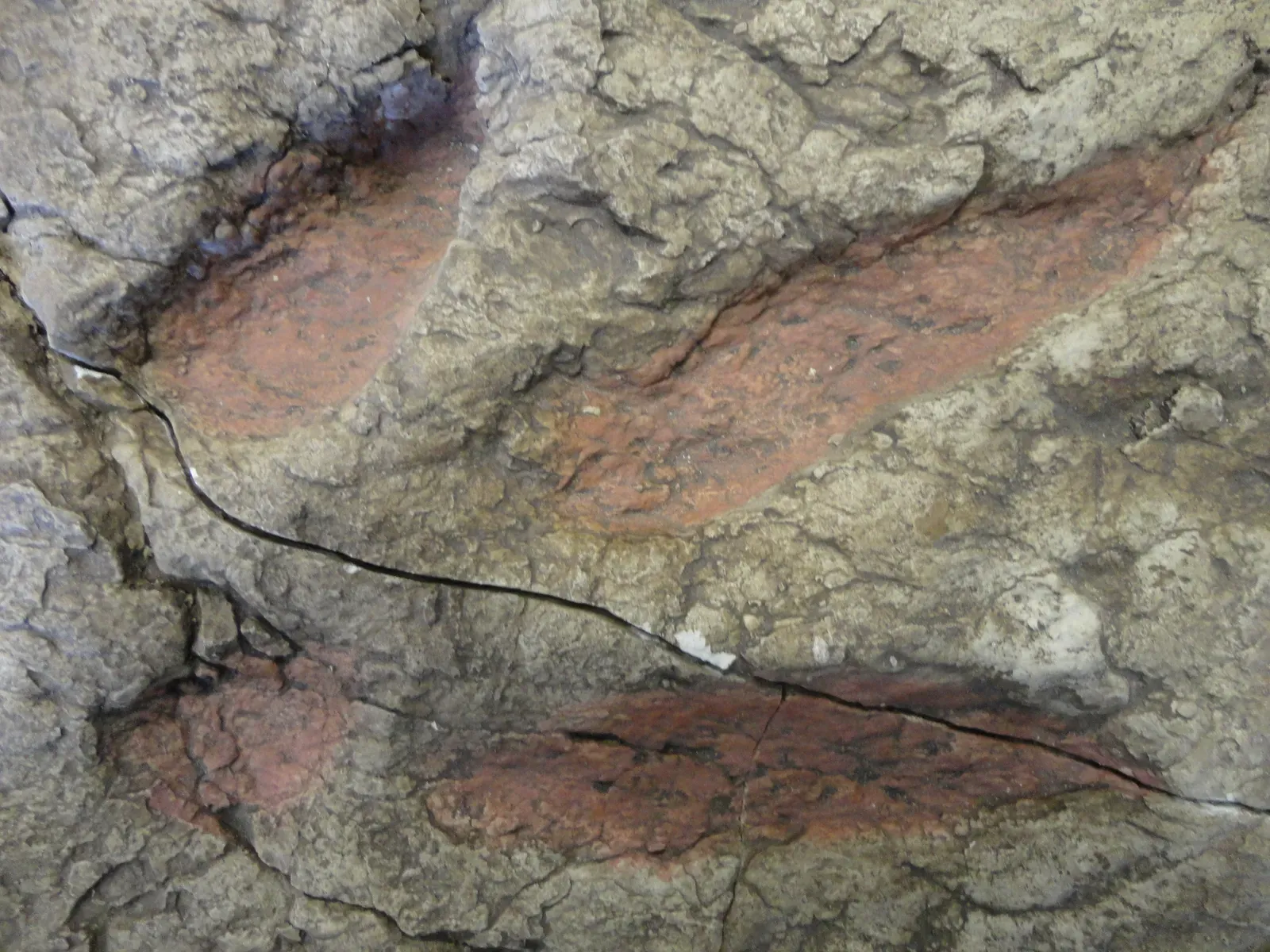
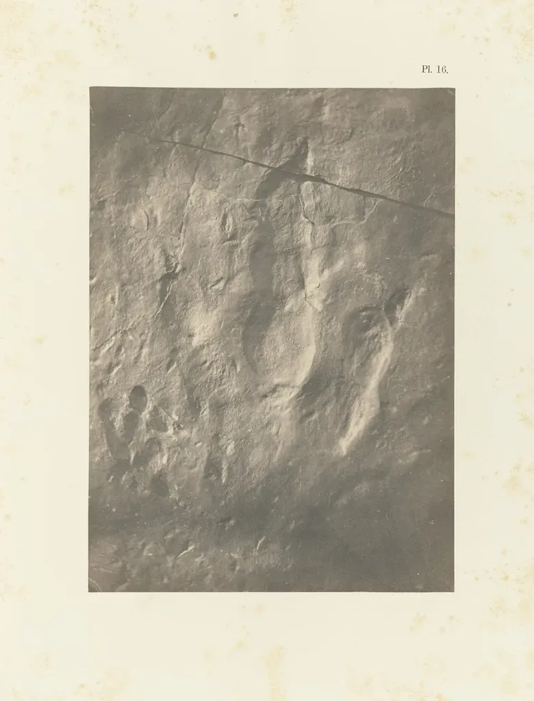
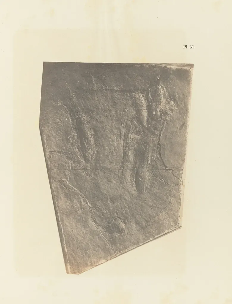
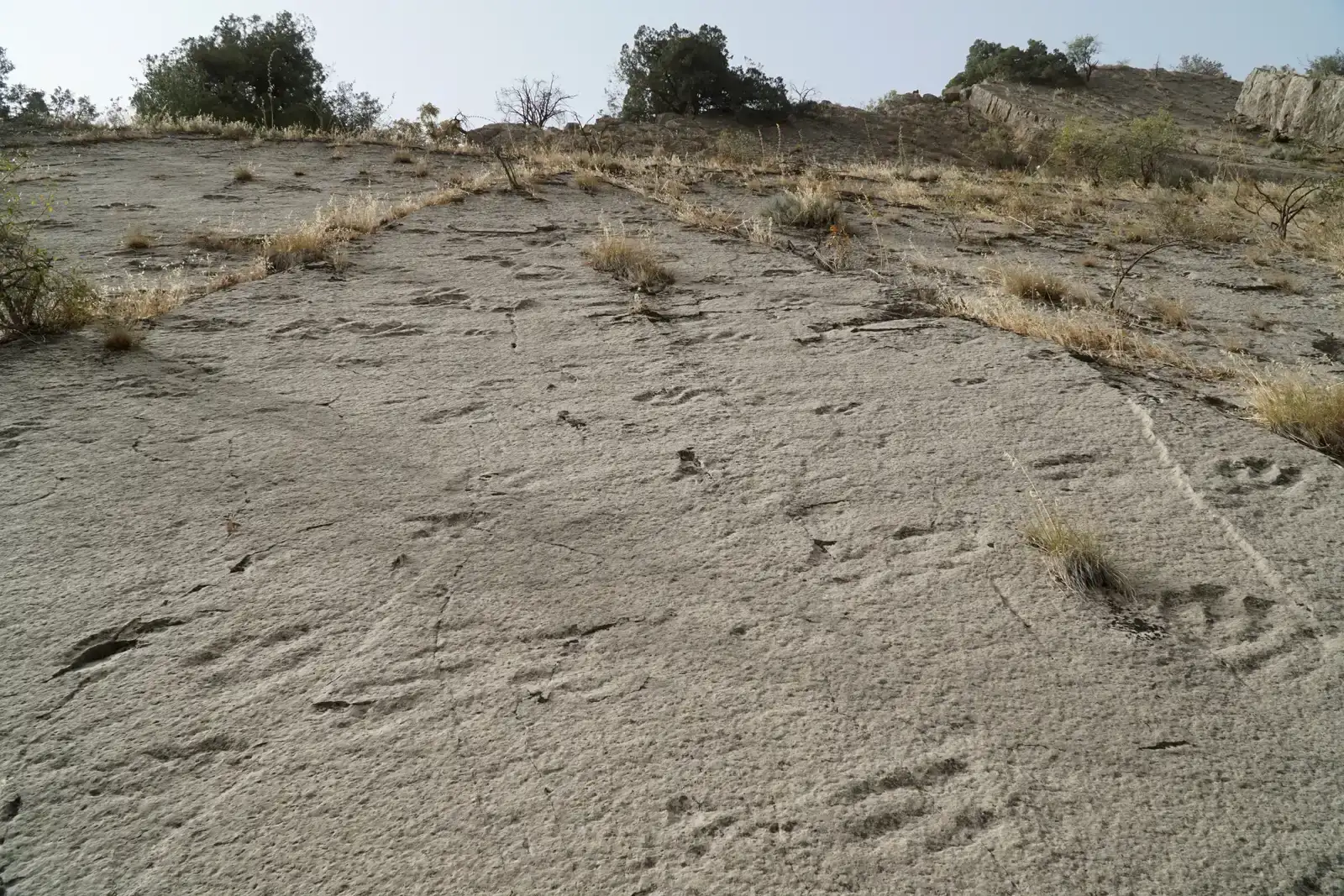
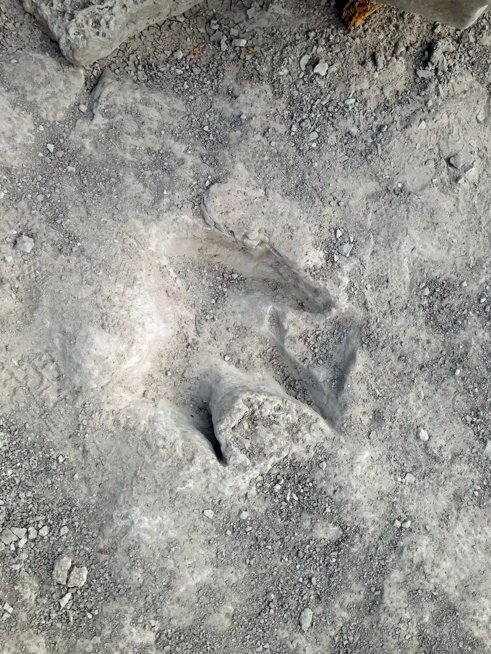
The most striking thing about the latest Texas discoveries is how utterly accidental they are. In places like Dinosaur Valley State Park near Glen Rose, record-low water levels in late summer have exposed long trackways that had been hidden for decades beneath the Paluxy River. What looked like an ordinary stretch of murky water turned out to be a stone-tough diary written by giant sauropods and sharp-clawed theropods. Suddenly, you can see a line of deep, rounded prints from a long-necked dinosaur marching side by side with three-toed tracks from a predator that once towered above most cars.
Standing on those tracks, researchers describe a strange sense of intimacy, as if someone had just walked past and vanished. The spacing and depth of each footprint reveal how fast the dinosaur was moving, how much it weighed, and how the ground responded under its feet. A slightly deeper impression here, a tighter curve there – these small variations hint at momentary changes in speed or terrain the way smudges in a handwritten note hint at hesitation. What was once abstract – “a giant herbivore lived here” – becomes concrete: an animal took this exact step, then the next, then the next, across what is now North Texas.
From Riverbed Mystery to Field Lab
Once the tracks appear, the clock starts ticking. Exposure to sun, wind, boot traffic, and the inevitable return of floodwaters means scientists have only a narrow window to document what the drought has revealed. Teams quickly move in with cameras, drones, photogrammetry software, and old-fashioned plaster to capture every ridge and crack of the prints. They work in the summer heat while visitors look on from the edges, turning a quiet state park into an open-air field lab. It is messy science, full of mud-caked boots, improvised shade tents, and gear laid out along the riverbed like an emergency response operation.
For anyone accustomed to the tidy image of labs with white coats and microscopes, this kind of work feels more like archaeology mixed with disaster response. Researchers race thunderstorms, equipment failures, and park schedules, knowing that one strong flood could erase the newly uncovered trackways for years. At the same time, they have to balance preservation and access: protect the prints, but share the excitement with the public that ultimately funds and supports this research. That tension – urgent, public, imperfect – is part of what makes these Texas footprints feel so alive.
Reading the Footprints: Who Walked Here and How
What makes these discoveries scientifically powerful is not just that new footprints exist, but the level of detail they offer about dinosaur behavior. The large, elephant-like tracks in Texas riverbeds are typically attributed to sauropods, long-necked giants that may have weighed as much as several modern elephants combined. Nearby, narrow, three-toed prints likely belong to carnivorous theropods, relatives of well-known predators like Acrocanthosaurus that once hunted across what is now the American South. The arrangement of these tracks sometimes shows parallel paths, pacing distances, and even apparent changes in direction.
From that layout, paleontologists infer things they could never see from bones alone. Did these sauropods move in groups, like modern elephants, or alone like some of today’s larger herbivores? Are the predators tracking the herds, cutting across their paths, or ignoring them entirely? Subtle differences in stride length or print spacing can hint at whether a dinosaur was walking slowly through soft sediment or striding more briskly across firmer ground. It is the difference between looking at skeletons in a museum and watching frozen frames of a nature documentary from one hundred million years ago.
From Ancient Tools to Modern Tech
Just a few decades ago, recording a dinosaur trackway meant tape measures, hand-drawn diagrams, and perhaps a few plaster casts that were heavy, fragile, and hard to store. Today, Texas track sites are being scanned in three dimensions using techniques originally built for engineering and film. With photogrammetry, scientists take overlapping photographs from multiple angles and feed them into software that stitches together a highly accurate 3D model of every footprint. Drones swoop over the exposed riverbed, capturing angles no ladder or scaffold could safely provide.
Those digital trackways can then be analyzed in ways that were nearly impossible using hand-drawn maps. Researchers can simulate how different dinosaur body plans would create different pressure patterns, test hypotheses about gait or weight, and share the entire site with colleagues around the world without moving a single rock. Some teams even use virtual reality headsets to “walk” along the trackways, adjusting height and stride to match proposed reconstructions of the animals. It is a strange combination: soft mud hardened into stone by time, now turned back into data points floating onscreen in a lab, allowing scientists to rewind and replay ancient steps with unprecedented precision.
Why It Matters Beyond Dinosaur Fandom
It is tempting to dismiss these Texas tracks as simply another cool dinosaur story, the sort of headline that lights up social media for a day and then fades. But they matter for deeper reasons. Footprints capture moments in time that bones almost never can: how many individuals were present, how fast they were moving, what the surface was like, whether they were traveling together. That behavioral snapshot helps refine models of ancient ecosystems, population sizes, and predator-prey dynamics. In turn, those models feed into bigger climate and evolutionary questions, such as why certain lineages thrived while others vanished.
The Texas discoveries also show how strongly local landscapes shape what survives into the fossil record. A shallow coastal plain here, a slow river channel there, and suddenly you have a perfect recipe for preserving a morning’s walk for more than a hundred million years. Understanding those conditions helps scientists better interpret track sites in other parts of the world and distinguish between patterns caused by animal behavior and those produced by erosion or chance. In a broader sense, these findings remind us that Earth’s history is not a neatly bound book but a patchwork of surviving pages that we’re still learning how to read.
Climate Extremes as Unwanted Field Assistants
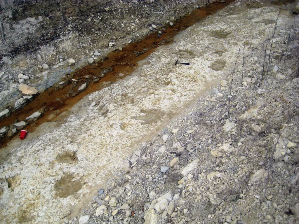
There is an uncomfortable twist to the story: many of these newly visible Texas footprints are appearing because of extreme weather linked to a warming climate. Prolonged droughts lower river levels and strip away protective sediment, uncovering trackways that have been hidden for decades or centuries. In some cases, residents first notice the prints while simply walking along an unusually dry riverbank or fishing in spots that are normally underwater. Those chance encounters then turn into rapid mobilizations by park staff and researchers to document what has emerged.
But the same forces that reveal the tracks also threaten them. Once exposed, the prints are more vulnerable to cracking, vandalism, and being scoured away by the next intense flood – a cycle of destruction and discovery driven by increasingly volatile weather patterns. It is a strange feeling to realize that the fingerprints of ancient climate conditions are being exposed by our own. While no one is happy about worsening droughts, scientists are acutely aware that some of the most spectacular glimpses into deep time are now arriving on the back of very modern environmental stress.
Texas in a Global Dinosaur Story
Seen in isolation, the Texas trackways are impressive; seen in context, they are part of a global pattern of dinosaur footprints rewriting prehistory. Similar sites in places like Colorado, Utah, and New Mexico form a patchwork along what used to be ancient shorelines and floodplains across North America. Overseas, track-rich regions in China, Australia, South America, and parts of Europe show that dinosaurs were adapting to a huge variety of habitats, from high-latitude forests to tropical coasts. When scientists compare these sites, they are not just cataloging fossils – they are tracing ancient migration routes and climate belts.
Texas occupies a particularly interesting piece of that map because it sat along an inland seaway during the Cretaceous period, a sort of warm, shallow marine corridor splitting the continent. The mix of marine sediments and terrestrial trackways in this region gives researchers clues about how coastal ecosystems responded to rising and falling sea levels. As new tracks appear and are added to this growing global dataset, they help refine our understanding of dinosaur diversity and distribution, much like adding new stations on an ancient transit map. Each footprint may be small compared to a skeleton in a museum hall, but collectively they sketch the outlines of entire lost worlds.
The Future Landscape of Dinosaur Discovery
Looking ahead, the next breakthroughs in Texas dinosaur research may come less from new shovels in the ground and more from smarter ways of scanning what is already there. Scientists are experimenting with ground-penetrating radar, lidar, and other non-invasive techniques to detect buried surfaces that may host trackways before they are exposed by erosion. Combined with detailed elevation and hydrology data, these tools could help predict which stretches of river or lakebed are most likely to yield new prints during future droughts. It is a shift from passively waiting for nature to reveal secrets to actively mapping where those secrets are likely hiding.
At the same time, there are serious questions about how to conserve these fragile sites in a changing climate and a rapidly growing state. Protecting trackways may require new policies, more funding for parks and museums, and agreements with private landowners whose property may sit atop scientifically priceless surfaces. Digital archives and 3D-printed replicas will help, but they cannot fully replace the visceral impact of standing where a dinosaur once stood. The challenge over the next few decades will be to blend cutting-edge technology with boots-on-the-ground stewardship so that both present-day Texans and future generations can still walk alongside those ancient steps.
How Readers Can Step Into the Story
For most people, dinosaur science can feel distant, like something that happens in far-off deserts or behind museum doors. Texas trackways offer a different kind of entry point: you can literally go see where the animals walked. Visiting parks that protect these footprints, following posted guidelines, and supporting local conservation efforts may sound modest, but those small actions add up. When park attendance is strong and respectful, it becomes easier for managers to argue for more funding, more staff, and more scientific partnerships. Even something as simple as choosing to share accurate information instead of sensational rumors helps keep the public conversation grounded and supportive.
If you live far from these sites, there are still ways to plug in. Many research teams and museums now share 3D models of trackways online, along with behind-the-scenes field notes and project updates. Donations to trusted institutions, volunteering with local nature centers, or encouraging schools to invite working scientists to speak can all help keep this kind of research moving forward. In a world where so much ancient history has been erased by time, the fact that any dinosaur footprints remain at all is a minor miracle. The question now is whether we will treat them as passing curiosities or as rare, irreplaceable chapters in the story we all share.

Suhail Ahmed is a passionate digital professional and nature enthusiast with over 8 years of experience in content strategy, SEO, web development, and digital operations. Alongside his freelance journey, Suhail actively contributes to nature and wildlife platforms like Discover Wildlife, where he channels his curiosity for the planet into engaging, educational storytelling.
With a strong background in managing digital ecosystems — from ecommerce stores and WordPress websites to social media and automation — Suhail merges technical precision with creative insight. His content reflects a rare balance: SEO-friendly yet deeply human, data-informed yet emotionally resonant.
Driven by a love for discovery and storytelling, Suhail believes in using digital platforms to amplify causes that matter — especially those protecting Earth’s biodiversity and inspiring sustainable living. Whether he’s managing online projects or crafting wildlife content, his goal remains the same: to inform, inspire, and leave a positive digital footprint.