It looks like a magic trick: a shimmering lake blooms across a dead-flat desert floor, locals gasp, drones hum overhead – and then, just days later, the water is gone as if someone pulled a plug. These ephemeral basins, known as playas, sabkhas, or endorheic pans, are nature’s fast-forward button for hydrology. They turn violent cloudbursts into instant mirror-worlds and then erase the evidence under an unforgiving sun. Scientists see more than spectacle; they see a diagnostic test for a warming climate’s new rhythm of extremes. The mystery isn’t just how quickly these lakes appear and vanish, but what they reveal about hidden groundwater, fragile crusts, and the fine line between flood relief and dust disaster.
The Hidden Clues
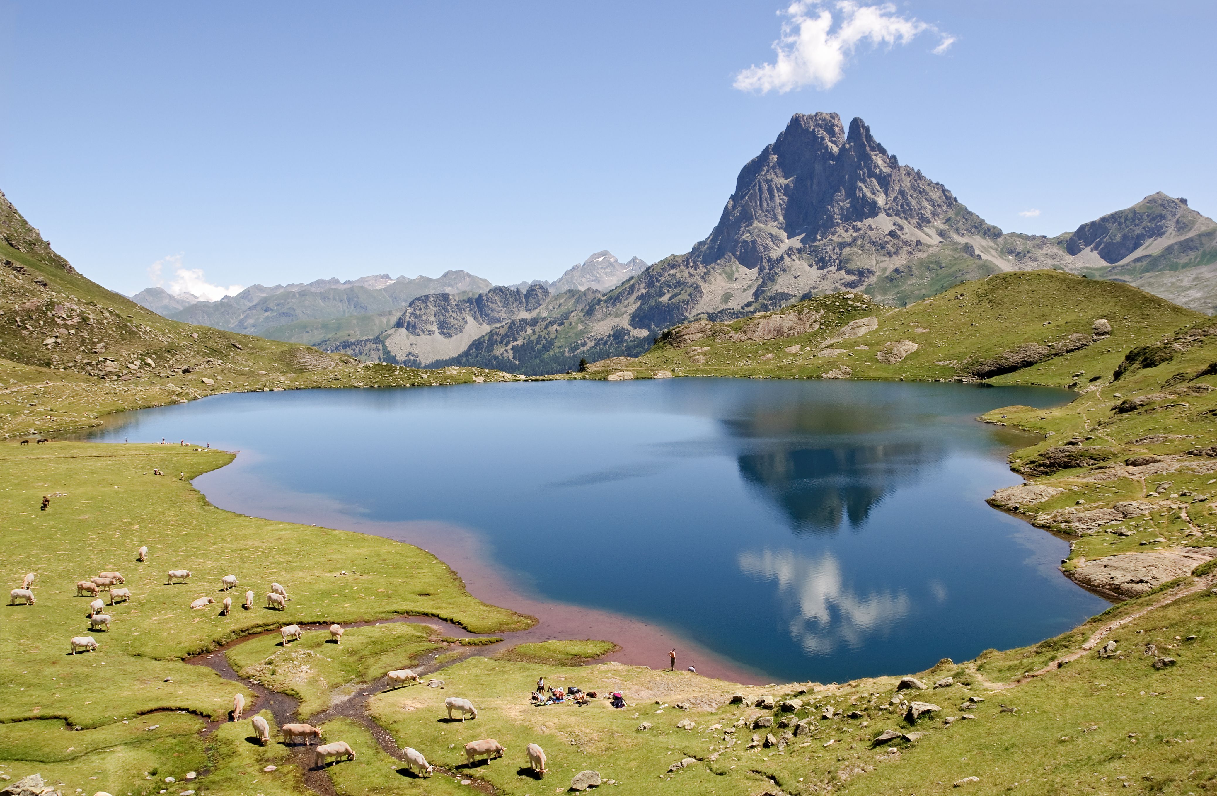
What if a puddle the size of a city could tell you how a desert breathes? When a storm hits an endorheic basin, water has nowhere to go but sideways and downward, painting the ground with a thin, gleaming film. Beneath that mirror lies a layered archive of salts, clays, and silt that swells, cracks, and locks in traces of each flood. A few centimeters of depth can cover many square miles, so a basin that looks like a lake may be as shallow as a bathtub. I once stepped onto a glassy crust that seemed solid and sank to my ankles – an instant lesson in how deceptive these surfaces can be.
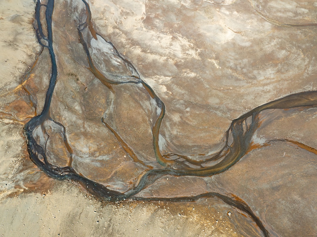
As the surface dries, capillary action pulls water upward while heat yanks it skyward, leaving behind white polygons like fractured porcelain. The geometry isn’t just pretty; polygon size and spacing whisper about evaporation rates and soil minerals. Even the stains along the shoreline serve as temporary tree rings, mapping wave run-up and wind direction in a single afternoon. And when the water vanishes, a faint line of driftwood, insects, and salt foam marks the high stand like a measuring tape left by the storm. Blink, and much of this evidence fades, but for a brief window the lake tells its entire story in plain sight.
From Ancient Tools to Modern Science
Long before satellites, travelers read playas the way sailors read the sea, scanning for mirages, darkened ground, and the glint of wet clay. Archaeologists still find ancient camps along these margins, where water and wildlife once paused just long enough for people to gather and move on. The old method was simple: watch the sky, feel the wind, test the crust, and trust local memory about the last big storm. Today, that intuition meets a fleet of instruments, from rain radars tracing storm cells to sensors that weigh subtle moisture changes across an entire landscape. The partnership matters because neither story is complete without the other.
Orbiting eyes add the missing frame-by-frame detail. Optical satellites map the lake’s edge when clouds part; radar peers through weather and darkness to track inundation hour by hour. Thermal data gauges surface drying, while microwave sensors estimate soil moisture and hint at recharge beneath the veneer of water. Drones stitch ultra-high-resolution mosaics of cracks and salt blooms, letting scientists test how crusts fracture and heal across days. When the lake is gone, altimeters and repeat satellite passes preserve its brief biography in pixels and numbers.
Lightning-Fast Hydrology
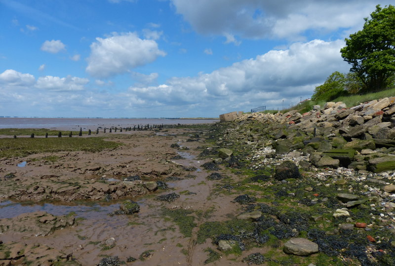
In arid basins, the math is brutal and fast: rainfall arrives in a rush, infiltration is patchy, and evaporation can devour a shallow lake in the time it takes a city park to dry. Playas are almost perfectly flat – think a slope gentler than a kitchen countertop – so a few millimeters of water can spread astonishingly far. Evaporation in hot, dry air can climb to meters per year when averaged, which means a lake mere inches deep may last days, not weeks. Add wind, and the lake sloshes like water on a tray, pushing shorelines back and forth and concentrating brine in quiet corners. The same wind that paints ripples can also lift wet dust when crusts weaken.
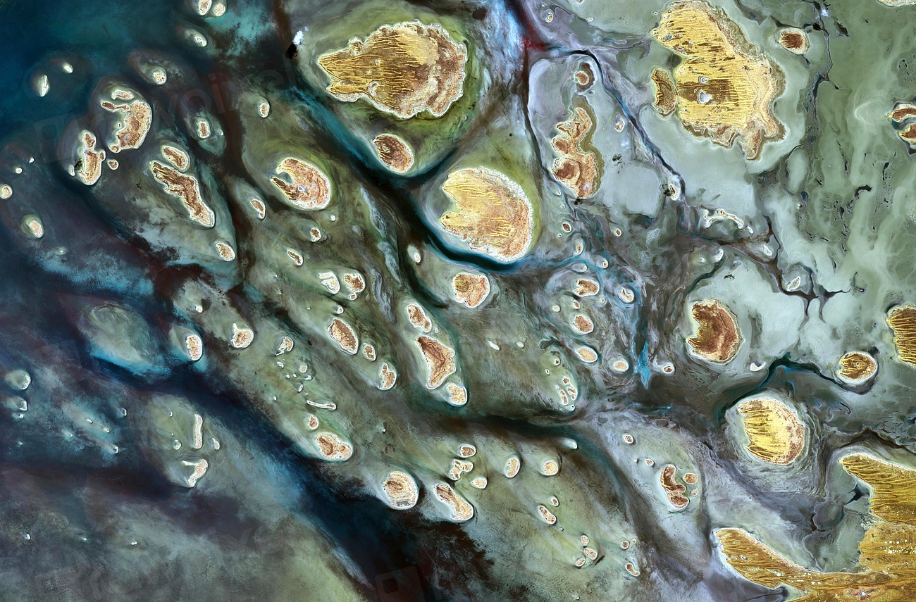
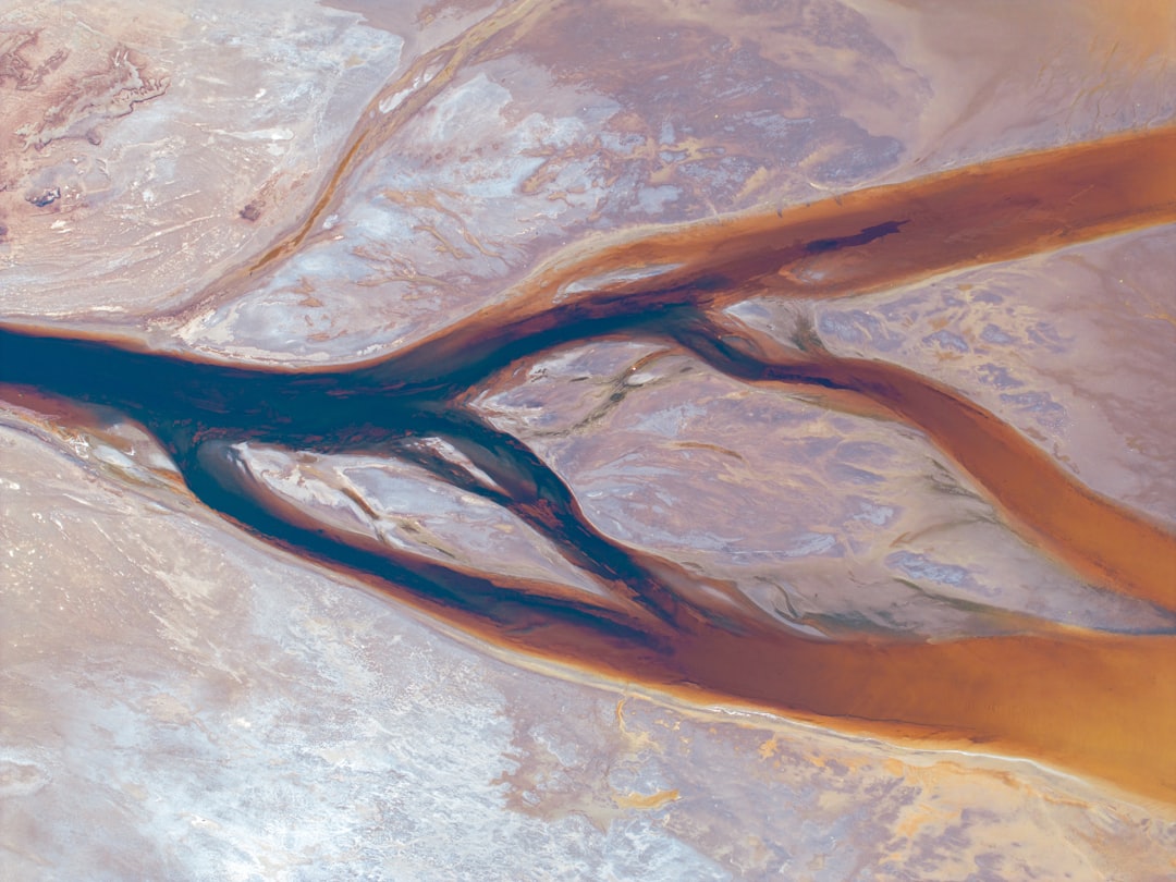
Most water leaves upward as vapor, but a thin slice leaks downward to wake shallow aquifers. Where sediments are coarse, floodwater vanishes quickly into the alluvial fan; where clays dominate, water lingers and then flashes off at the surface. As salinity ramps up, chemistry shifts and minerals precipitate – halite, gypsum, and more – writing a mineral logbook of the flood. Microbial communities bloom in hours, tinting water tea-brown or jade as if the basin mixed its own dye. By week’s end, what remains is a freshly reworked skin ready for the next surprise.
The Human Footprint
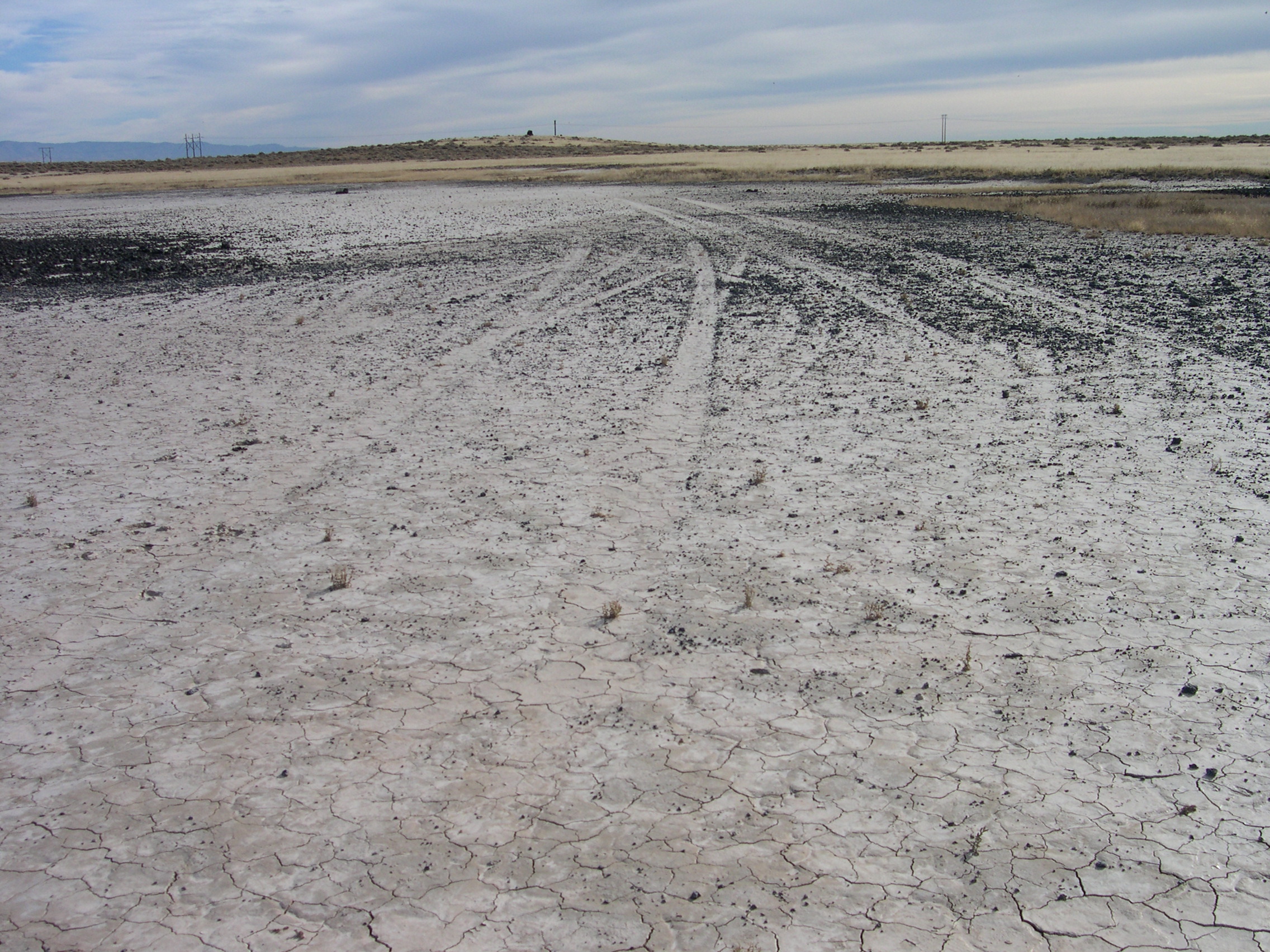
Ephemeral lakes are seductive to the eye and treacherous to the foot. Tires break the salt crust into slurry, leaving ruts that channel the next flood and accelerate erosion. Photographers chase reflections and sometimes drive onto surfaces that look dry but behave like pudding, requiring costly rescue and scarring the playa for years. Infrastructure isn’t immune; roads dipped across basins can undercut from below when water sheets along hidden layers. Airstrips and test ranges on dry lakes depend on predictable crusts, and an unseasonal flood can shut them down as if a switch were flipped.
There’s an economic edge too. Resource projects near salt flats, from potash to brine minerals, must dance around unpredictable water pulses that dilute concentrations and force shutdowns. Tourism spikes during rare fillings, then drops as mud returns, whipsawing small businesses. Indigenous communities bring deep knowledge of how to move with the water, but that knowledge is often sidelined when schedules trump seasons. And when the last puddle dries, exposed fine sediments can loft into the air, nudging dust toward towns and crops downwind. What looks like a short-lived lake can leave a long-lived footprint.
Why It Matters
Ephemeral basins are diagnostic tools for a climate tilted toward extremes. They spike to life during intense storms and go quiet during extended drought, turning their floodlines into a running archive of volatility. Compared with traditional stream gauges that miss water in closed basins, playas reveal off-channel storage, quick infiltration, and the speed of surface-atmosphere exchange. They also act as pressure valves by parking water temporarily, slowing runoff that might otherwise scour roads and arroyos. Ignoring them is like ignoring a fever because the thermometer is in the wrong room.
There’s a public health angle hidden in the mud cracks. Wet periods suppress dust that carries salts and metals; dry, windy spells loft it again, aggravating lungs and coating solar panels miles away. Emergency planners benefit from knowing which basins reawaken after cloudbursts, where vehicles will bog down, and how long detours should last. Ecologists track brief pulses of habitat – shoreline invertebrates, microbes, and scavengers – that ripple through food webs far beyond the basin rim. In a world chasing water security, these fleeting lakes are not sideshows; they’re systems tests.
Global Perspectives
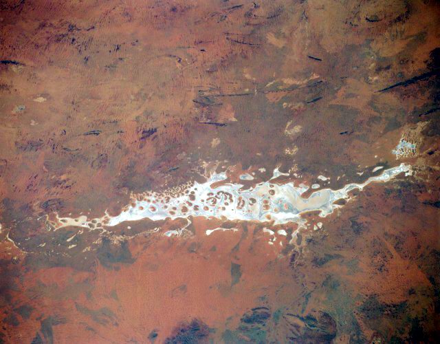
The phenomenon is planetary, even if the names differ. Australia’s inland pans pulse like a heartbeat, sometimes visible from space after tropical incursions push far inland. North African chotts, Middle Eastern sabkhas, and South American salars each write their own chemistry depending on the minerals in the catchment. In the American Southwest, basins embedded in alluvial fans flare into view after monsoon bursts and the occasional landfalling remnant of a tropical storm. In the Atacama and high Andes, thin water films race across salt crusts, then retreat, leaving gleaming expanses that look like ice but crunch like sugar.
Each region adds a twist. Some basins lie over ancient lakebeds that once hosted permanent water before climate and tectonics closed their outlets. Others fringe mountain fronts where debris flows deliver fresh sediment, resetting the canvas after each wet episode. Even the sky’s personality matters: slow, soaking storms carve different signatures than sudden downpours that arrive with thunder and leave with dust. Despite the variety, the choreography repeats – fill, spread, concentrate, vanish – like a global refrain in different keys. That repetition is a gift for scientists who compare notes across continents.
The Future Landscape
New satellites promise to make these blink-and-you-miss-it lakes far harder to miss. Radar missions track inundation through cloud and night, while thermal sensors flag when surfaces cross from wet to dry. Airborne lidar and compact drones capture the micro-topography that dictates where a basin first pools and last holds on. AI models are getting better at nowcasting flood spread on near-flat terrain, a task that once stumped computers because a tiny slope error created a phantom river. Add open data platforms, and field teams can be on site while the last ripples still run.
But challenges loom as large as the sky. Faster swings between drought and deluge could strain crusts and spark more dust once the water retreats. Remote sensing needs ground truth – boots, sensors, and yes, stuck trucks – to stay honest about what pixels really mean. Managers will juggle access closures, public safety, fragile habitats, and the lure of tourism when the lakes appear. And the ultimate question remains: will the basins see more frequent brief floods, fewer but deeper ones, or both depending on where you stand?
From Sediment Diaries to Climate Records
Every filling writes a new page in the basin’s sediment diary. As the lake concentrates, different minerals drop out in sequence, creating bands that future cores can read like a barcode of chemistry and climate. Grain size tells a tale too, with coarser pulses marking energetic inflows and finer layers settling during calm, evaporative pauses. Even fossilized mud cracks carry clues about drying rates and seasonal timing. When researchers stack these pages, they reconstruct centuries of flood rhythm without a single gauge.
Modern tools extend the diary into near-real time. Repeat satellite passes measure subtle height changes, estimating water volume when gauges are impossible to deploy. Geophysical surveys map the shallow subsurface to see how much water sneaks below the crust and how fast it returns to the air. Comparing today’s pulses with the past reveals whether storms are shifting toward shorter, sharper bursts. In deserts, that shift can decide which towns flood and which ones fill their aquifers.
Fieldcraft and Safety in a Vanishing Shoreline
Reading a playa is part science, part street smarts. Ground that looks dry can hide a gelatinous layer just beneath the crust, especially along fresh shorelines where waves worked the surface. Footprints that hold for one person can liquefy under a parked vehicle, and tracks that seem safe in the morning can vanish under afternoon wind-driven slosh. Seasoned field crews carry wide boards for jacks, recovery straps, and a plan for turning around at the first sign of glue-mud. The best photo is never worth a stuck axle.
Timing matters as much as terrain. Early mornings bring cooler surfaces and slower evaporation; afternoons amplify glare and heat, reshaping edges while you watch. Lightweight shoes become anchors once clays saturate, and every kilogram of mud you carry makes the walk out longer. Keeping to established access points protects the fragile crust that the next flood needs to spread smoothly. When in doubt, treat the playa like thin ice with sunshine.
Conclusion
You don’t need a lab to help read these lakes – just curiosity and a light touch. If a desert basin in your region floods, resist the urge to drive onto it, and share the same advice with friends who might not know the risks. Support land managers when they close access after storms; those days protect both people and the crust that keeps dust down. If you photograph a filling, note the date, rough depth, and shoreline changes, and share observations with local science groups that track ephemeral waters. Citizen notes, paired with satellite passes, turn a fleeting spectacle into usable data.
Consider backing programs that monitor dust, soil moisture, and flood risk in arid lands, and encourage event organizers to rethink gatherings on dry lakes after heavy rain. The next time a desert turns into a mirror, let it shine undisturbed, and help others see it as a living gauge, not a stunt track. Tiny choices ripple across these vast, flat places. What part will you choose to play when the lake returns?

Suhail Ahmed is a passionate digital professional and nature enthusiast with over 8 years of experience in content strategy, SEO, web development, and digital operations. Alongside his freelance journey, Suhail actively contributes to nature and wildlife platforms like Discover Wildlife, where he channels his curiosity for the planet into engaging, educational storytelling.
With a strong background in managing digital ecosystems — from ecommerce stores and WordPress websites to social media and automation — Suhail merges technical precision with creative insight. His content reflects a rare balance: SEO-friendly yet deeply human, data-informed yet emotionally resonant.
Driven by a love for discovery and storytelling, Suhail believes in using digital platforms to amplify causes that matter — especially those protecting Earth’s biodiversity and inspiring sustainable living. Whether he’s managing online projects or crafting wildlife content, his goal remains the same: to inform, inspire, and leave a positive digital footprint.