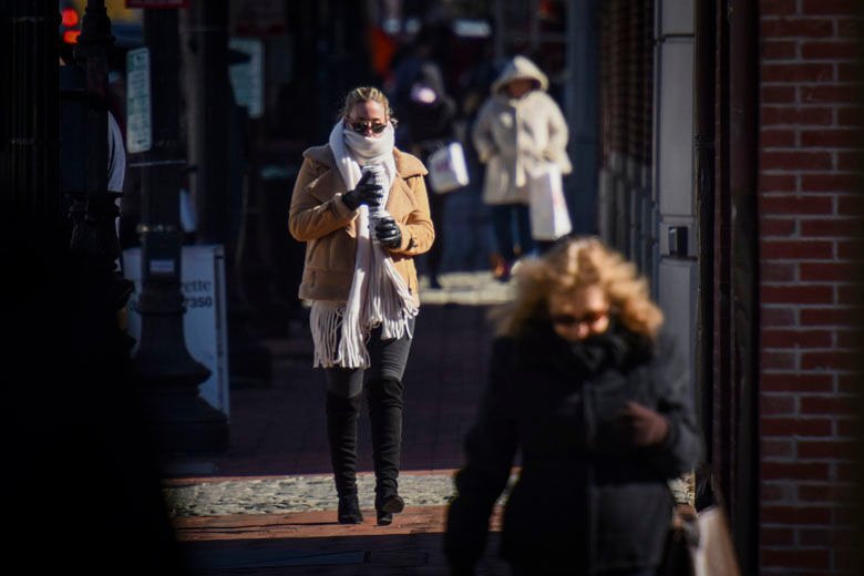
The Arctic Front’s Swift Arrival (Image Credits: Wtop.com)
Washington, D.C. – Residents woke to the sharp bite of winter’s grip on Tuesday morning, marking the coldest start to a day this season amid an arctic surge sweeping the area.
The Arctic Front’s Swift Arrival
An arctic front barreled through the region overnight, plunging temperatures into the teens and delivering wind chills that dipped near zero by dawn. This cold snap followed a weekend of scattered snow flurries and rain, which had already hinted at the harsher weather to come. Meteorologists from the National Weather Service noted the front’s rapid advance, pushing highs no higher than the low 20s for the day. The chill persisted through the afternoon, with gusty winds amplifying the discomfort for anyone venturing outdoors.
Communities across the District, Maryland, and Virginia felt the full force of the freeze. Urban areas like downtown D.C. saw sidewalks slick with a thin frost layer, while rural spots northwest of the city reported even lower readings. This marked a stark contrast to the milder conditions earlier in the week, when temperatures hovered around freezing. Officials urged caution for vulnerable populations, including the elderly and those without adequate heating.
Weekend Prelude Sets the Stage
The path to this frigid morning began over the weekend, when a mix of rain and snow brushed the region on Sunday. Light accumulations dusted higher elevations, but the real shift came with the cold air mass that followed. Forecasts from local outlets like WTOP and The Washington Post highlighted the potential for a weekend winter storm, though it largely fizzled into flurries for most. Still, the system locked in the colder pattern, priming the area for Tuesday’s extremes.
By Monday evening, the mercury began its descent, with overnight lows settling in the upper teens. Wind chills exacerbated the raw feel, making it seem like single digits across much of the metro area. This episode echoed broader winter outlooks for 2025-2026, which predicted variable La Niña influences leading to bouts of intense cold. Early season data showed the region already logging below-average warmth, underscoring the unpredictability of the season.
Daily Disruptions from the Deep Freeze
The cold wave disrupted routines throughout the day. Schools and some businesses opted for delayed openings or remote operations to shield students and staff from the hazardous conditions. Commuters faced icy roads on major routes like I-95 and the Beltway, where black ice formed in shaded areas despite salt trucks working overtime. Emergency services reported a uptick in calls related to heating failures and minor slips on untreated surfaces.
Public health advisories emphasized layering up and limiting outdoor exposure, particularly during the morning and evening hours when the chill peaked. Air quality remained stable, but the dry, cold air irritated respiratory systems for some. Farmers in outlying counties monitored livestock, ensuring access to shelter and unfrozen water sources amid the freeze.
Preparation Essentials for the Cold
To navigate such weather, experts recommend stocking essentials and planning ahead. Key items include extra blankets, non-perishable food, and a full tank of gas to avoid stranding in the cold.
- Dress in layers with moisture-wicking base layers to trap body heat effectively.
- Check smoke and carbon monoxide detectors, as heating systems strain under low temperatures.
- Insulate windows and doors to retain indoor warmth without overworking furnaces.
- Stay informed via apps from AccuWeather or the National Weather Service for real-time updates.
- Assist neighbors, especially the elderly, by offering rides or welfare checks.
A Glimpse of Warmer Days
Relief appears on the horizon as a gradual warm-up takes hold starting midweek. Highs are expected to climb into the 30s by Wednesday, with winds easing to allow for more comfortable conditions. This thaw follows the classic pattern of arctic outbreaks, where cold air masses yield to milder southern flows. Long-range forecasts suggest the winter will continue with fluctuations, influenced by a transitioning La Niña pattern that could bring more snow chances later.
While the immediate freeze tests resilience, it serves as a reminder of the region’s variable climate. The brief respite offers time to recharge before potential storms brew over the weekend.
Key Takeaways
- The coldest morning of the season brought wind chills near zero and highs in the 20s.
- Weekend flurries preceded the arctic front, setting up the deep chill.
- A slight warm-up begins Wednesday, with temperatures rising to the 30s.
As the DC area shakes off this icy start, the contrast between bitter cold and emerging warmth highlights winter’s dynamic nature. What are your plans to stay cozy through the next chill? Tell us in the comments.