
A powerful winter storm system that intensified into a bomb cyclone has slammed across the Great Lakes and Northeast, bringing heavy snow, frigid temperatures, strong winds and widespread travel disruption just ahead of the New Year’s holiday. The storm—dubbed Winter Storm Ezra by meteorologists—rapidly deepened as atmospheric pressure plunged rapidly, meeting the criteria for bombogenesis and creating blizzard-level conditions over a broad swath of the northern United States.
Forecasters warn that the impacts will ripple through travel networks and local communities, with snow, ice and strong winds expected to challenge roadways, airports and power infrastructure through the early days of 2026. From Michigan to New England, millions are under winter weather alerts as emergency agencies mobilize ahead of continued cold and accumulating snow.
What Is a Bomb Cyclone and How Ezra Formed
A “bomb cyclone” refers to a storm that undergoes bombogenesis, meaning its central pressure drops at least 24 millibars in 24 hours—a sign of rapid intensification. This phenomenon gives rise to hurricane-force winds, heavy snow and severe temperature contrasts. Ezra developed when a potent low-pressure system emerging from the Central Plains collided with abundant Arctic air, triggering explosive strengthening as it moved over the Great Lakes region.
The storm’s development was driven by the interaction of frigid air from the Arctic and moisture over the Midwest, fueling powerful lake-effect snow bands downwind of Lakes Erie and Ontario and generating snow totals well above seasonal norms in some areas.
Snow, Ice and Furious Winds Across the Great Lakes
As Ezra tracked northeast, parts of the Great Lakes region experienced blizzard-like conditions with heavy snowfall, whiteout conditions and high wind gusts. In Michigan’s Upper Peninsula, residents saw more than two feet of snow, while coastal areas reported waves over 20 feet on the lakes. Widespread power outages were reported, with hundreds of thousands of customers losing electricity as trees and lines succumbed to ice and wind.
Blowing snow and drifting created treacherous travel conditions, with the National Weather Service issuing winter storm and high wind warnings across much of Lower and Upper Michigan, including Lake Michigan shoreline communities where snow accumulation and gusty winds posed particular hazards.
Northeast Prepares for Snow, Ice and Wind
Once the storm shifted eastward, the Northeast braced for its own bout of winter weather, with forecasts showing snow, sleet and freezing rain spreading across major population centers, including upstate New York, Massachusetts and parts of New England. Snow squalls—brief but intense bursts of snow and wind—were also expected to reduce visibility and complicate travel.
Major metropolitan areas such as Buffalo, Syracuse, Boston and New York City were within the storm’s projected path, prompting travel warnings and advisories for motorists planning holiday trips. Northern interior regions could see ice accumulation approaching an inch in spots, creating additional risks on road surfaces.
Travel Chaos and Infrastructure Strain
The bomb cyclone’s impacts were already evident in travel networks: nearly 6,000 flights were delayed and more than 700 canceled as winter weather snarled operations across affected regions, from Midwest hubs to Northeast gateways. Airlines including Delta, United and American reported operational disruptions and extended delays, with carriers adjusting schedules and waiving change fees to help stranded passengers.
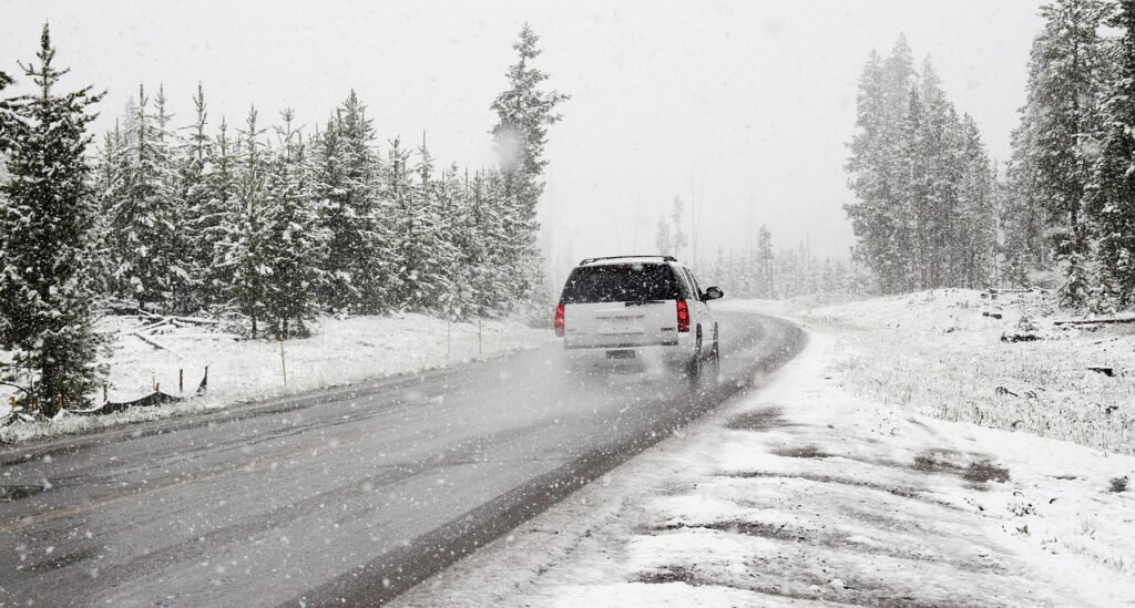
Road travel has been similarly challenging, with whiteout conditions and slippery surfaces prompting officials to urge drivers to delay non-essential travel. Whiteout and blizzard conditions intensify hazards particularly along major interstates linking the Midwest to the Eastern Seaboard.
Arctic Blast to Follow: Deepening the Chill
Behind the bomb cyclone, an Arctic air mass is sweeping southward, bringing dangerously cold temperatures far beyond the storm’s core. Subfreezing conditions are expected to dominate much of the East and Midwest as the new year begins, with wind chills plunging into the teens and single digits in many areas previously unaccustomed to such early-season cold.
This extended cold snap will sustain lake-effect snow events and further challenges for communities already coping with infrastructure strain, from snow removal to power restoration efforts.
Winter Storm Ezra’s rapid intensification into a bomb cyclone is a stark illustration of how volatile and impactful mid-winter weather systems can be, especially when Arctic air and moisture converge over the Great Lakes and Northeast. The storm not only disrupted holiday travel and power but also tested the resilience of infrastructure and emergency response systems already taxed by heavy demand. This event should serve as a reminder to policymakers and communities alike that investment in advanced weather forecasting, resilient power grids and winter preparedness planning is not optional—it is essential. With climate extremes and unpredictable weather patterns on the rise, the ability to anticipate, respond to and recover from events like Ezra will define how effectively regions withstand the challenges of a changing climate and a harsh winter season.