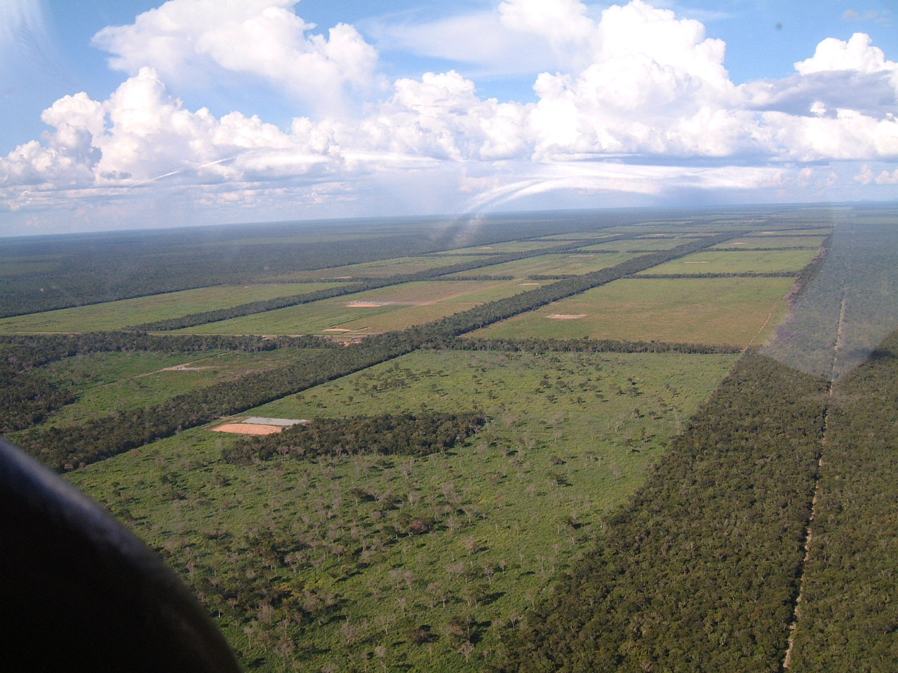
From a satellite’s quiet vantage point, the western Amazon looks like a sea of green – until sudden geometry interrupts the forest. Perfect circles pair with crisp squares, trenches trace long straight lines, and the earth itself seems to wear ancient tattoos. These shapes were hidden for centuries, but recent clearing for ranching and crops has peeled back the canopy and exposed vast earthworks. The reveal is both scientific windfall and cultural alarm: every new line in the dirt is a page of history turned – and sometimes torn. The mystery that drives researchers now is deceptively simple: who built these monuments, why did they do it, and when?
The Hidden Clues

The clearest clues emerged in the late twentieth century, when deforestation in Brazil’s Acre state exposed hundreds of geometric enclosures cut into the ground. From above, they appear as circles, squares, rectangles, and U-shapes, some connected by ditches as wide as a two-lane road. Most lie on interfluves – high ground between rivers – where the forest had long disguised them under bamboo and palm. The sheer precision is striking: many enclosures measure between roughly one and three football fields across, with banks and trenches laid out in clean, repeating ratios. What looked like unbroken wilderness turned out to be a palimpsest of human engineering, built long before European arrival. Archaeologists now tally more than four hundred such sites in Acre alone, with additional complexes in adjacent regions of Bolivia and Amazonas state.
From Ancient Tools to Modern Science
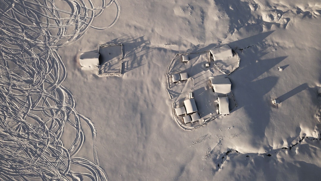
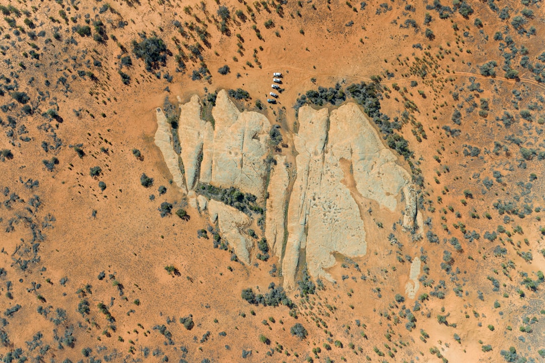
These earthworks were dug with pre-metal tools, yet their planning hints at surveying know-how and community labor on a grand scale. Today’s detectives bring a different toolkit: high-resolution satellites spot straight edges hidden in patchy pasture; drones skim low to map subtle relief; and lidar strips away vegetation in the data to reveal the full footprint beneath. Field teams then ground-truth the patterns, excavating postholes, collecting charcoal, and sifting for ceramics that can anchor timelines. I still remember the first time I panned across a satellite scene of Acre and watched a perfect ring snap into focus – like finding a compass-drawn signature under a thumbprint of clouds. It’s a strange partnership: modern pixels and ancient ditches, meeting in the middle to tell one story.
What the Earthworks Reveal About Purpose

The most convincing interpretation is that these were ceremonial or gathering s rather than villages or fortresses. Excavations recover surprisingly few everyday artifacts inside the enclosures, undercutting the idea of permanent settlement, and the ditch-and-bank architecture lacks defensive features typical of strongholds. Researchers have, however, found decorated pottery near entrances and evidence of repeated visits – hints of ritual events, feasts, or seasonal assemblies that drew people to shared ground. Think of them as open-air plazas engineered into living soil, places where communities moved, exchanged goods, and renewed social ties. The precise geometry may also have carried symbolic meaning that we’re only beginning to decode.
How Old Are These Shapes?
Dating combines radiocarbon samples from ditch fill, burned wood, and nearby soils with ceramic styles and stratigraphy to bracket construction and use. The weight of evidence places most activity between roughly the first and fifteenth centuries of the Common Era, with some sites possibly beginning earlier and others used into late pre-Columbian times. A charcoal sample from the well-studied Fazenda Colorada enclosure calibrates to the thirteenth and fourteenth centuries, while other trenches show earlier pulses of activity. Zoom out, and a pattern emerges: not a single empire, but long-lived, earth-building traditions evolving across centuries. In other words, these shapes weren’t a brief flourish; they were the steady heartbeat of regional societies for many generations.
Evidence at Ground Level
Walk the trenches and the subtler evidence starts to surface. Archaeologists encounter terra preta – rich, dark soils engineered by people – near some sites, alongside shards of domestic ceramics and stone tools beyond the enclosures. The surrounding forests show the fingerprints of past management: palms and useful tree species occur in patterns that paleoecological records tie to long-term human tending. Pathways and shallow causeways hint at processions, while platforms and entrances suggest controlled movement through . Even where artifacts are scarce, soil sequences capture cycles of light clearing and re-growth, telling us the builders opened small windows in the canopy without leveling the landscape. In those details, the Amazon looks less like untouched rainforest and more like a lived-in mosaic
Why It Matters

These earthworks overturn the old myth of a pristine Amazon devoid of complex societies and reshape debates about human impact in tropical forests. The emerging picture is nuanced: pre-Columbian communities profoundly shaped species composition and soils while avoiding the vast, contiguous clear-cuts driving today’s biodiversity loss. That contrast matters for climate models, conservation planning, and how we interpret resilience in rainforest systems. It also reframes Indigenous histories, demonstrating sophisticated land stewardship, monumental engineering, and social organization adapted to humid tropics. In short, the story is not “wilderness versus civilization,” but a spectrum of human–forest relationships across time.
Global Perspectives
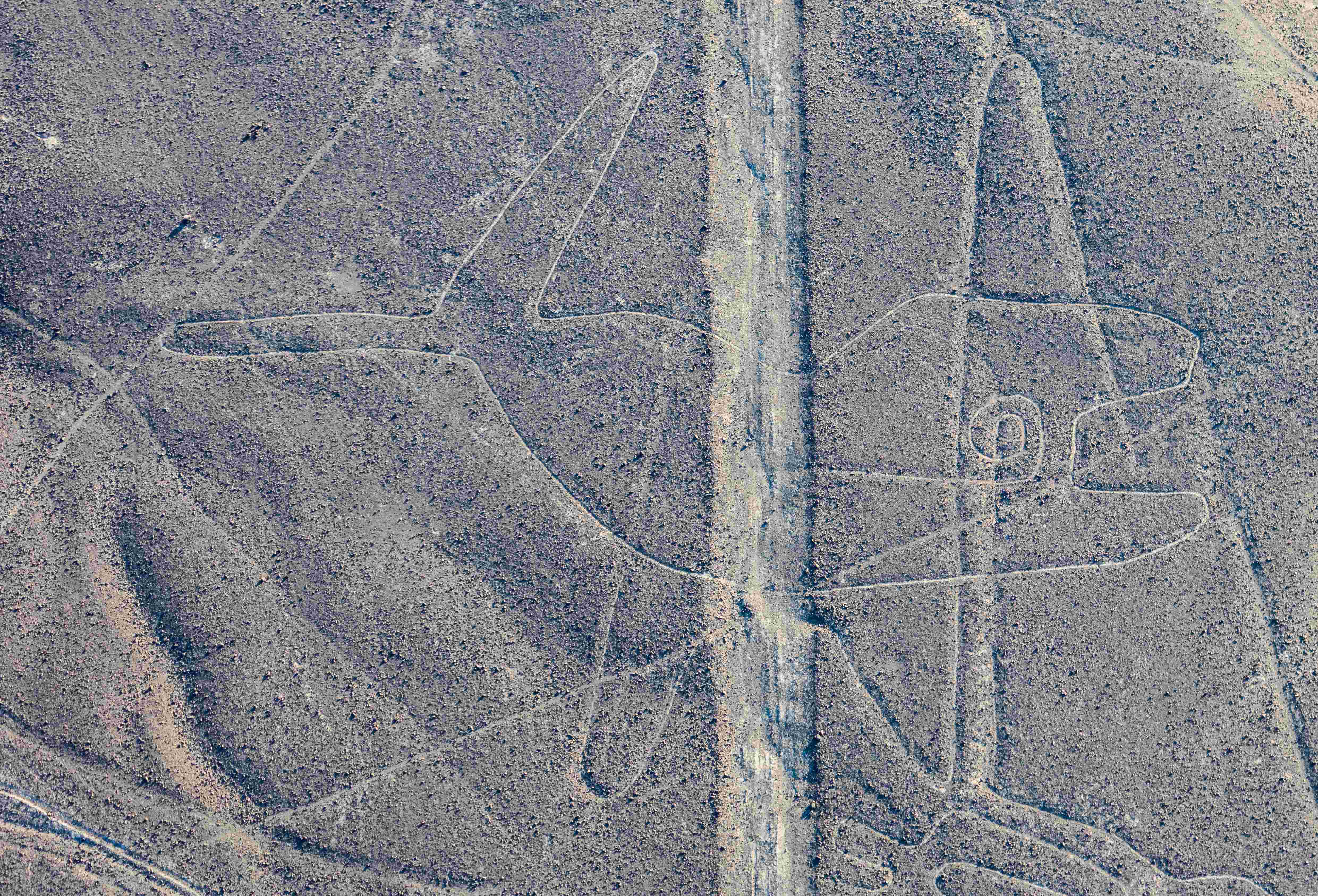
Seen from orbit, the Amazon’s geometric signatures invite comparison with other earth-drawn architectures – from Peru’s iconic desert lines to ring-ditch landscapes in Bolivia and ceremonial grids elsewhere. The differences are instructive: unlike figures etched into bare desert, these Amazonian forms were built to coexist with forest, their visibility toggled by vegetation and light. That makes them harder to find and, paradoxically, easier to lose, because a bulldozer can erase a ditch far faster than wind can scour a glyph from stone. It’s also why -based surveys matter: satellites can sweep regions where dense cover or private land access limits fieldwork. Understanding this broader family of ancient infrastructures helps archaeologists ask sharper questions about ritual landscapes, movement, and memory written on the ground.
The People Behind the Patterns

While labels like “geoglyph builders” are convenient, the archaeological record points to diverse, networked communities rather than a single culture. Villages have been found near some enclosures, and artifacts show local traditions connected by roads and river corridors. The engineering itself implies cooperation – organizing labor to dig, shape, and maintain trenches that still hold their line centuries later. Foodways likely tied gatherings to seasonal abundance, and engineered soils and orchards would have fed both daily life and ceremony. We may never know the original names or stories, but we can read intention in the way was shaped for people to come together.
The Future Landscape
Here is the paradox of the present: the same deforestation that reveals new earthworks also destroys them, sometimes within a single planting season. Preservation frameworks exist on paper, and the Acre geoglyphs sit on Brazil’s tentative list for UNESCO World Heritage status, but protection on the ground is uneven where agribusiness expands. New tools can help – machine learning to scan fresh satellite scenes for suspicious geometry, low-cost drones to document damage in near real time, and lidar to map sites before plows or fires reach them. Partnerships with local landowners and Indigenous organizations are equally critical, turning sites from obstacles into assets and pride points. Without that mix of policy, technology, and community action, too many lines in the earth will vanish before we fully learn to read them.
Conclusion
Start with awareness: if satellite images can change how we see the Amazon, so can a quick share of a verified map or museum exhibit about these sites. Support organizations working with Brazilian heritage agencies to document, stabilize, and steward earthworks, and be cautious about sharing precise coordinates that could invite looting or vandalism. Back policies – public and private – that tie commodity supply chains to real cultural-heritage safeguards, not just paperwork. If you’re an educator or tech professional, consider lending skills to open datasets, drone surveys, or machine learning projects focused on detection and monitoring. Most of all, remember that these shapes are not just curiosities on a screen; they’re the surviving edges of living histories that deserve room to breathe.

Suhail Ahmed is a passionate digital professional and nature enthusiast with over 8 years of experience in content strategy, SEO, web development, and digital operations. Alongside his freelance journey, Suhail actively contributes to nature and wildlife platforms like Discover Wildlife, where he channels his curiosity for the planet into engaging, educational storytelling.
With a strong background in managing digital ecosystems — from ecommerce stores and WordPress websites to social media and automation — Suhail merges technical precision with creative insight. His content reflects a rare balance: SEO-friendly yet deeply human, data-informed yet emotionally resonant.
Driven by a love for discovery and storytelling, Suhail believes in using digital platforms to amplify causes that matter — especially those protecting Earth’s biodiversity and inspiring sustainable living. Whether he’s managing online projects or crafting wildlife content, his goal remains the same: to inform, inspire, and leave a positive digital footprint.