You expect the Great Lakes to hide old anchors, beer cans, and the occasional long-lost anchor chain. What you do not expect is a stone circle that looks like a prehistoric monument, a Cold War fighter lying beside a teardrop-shaped mystery object, or a perfectly straight wooden pole that might rewrite a three-hundred–year-old shipwreck story. Yet when researchers, divers, and agencies map and sweep these “inland seas,” they keep running into things that simply do not fit any neat official box. Before you imagine sci‑fi movie plots, it helps to ground yourself: almost everything in the Great Lakes eventually has a human explanation. The problem is that in some cases those explanations are still fuzzy, unproven, or hotly argued over. So you’re left with a set of objects that have been found, documented, even handled – but not fully, formally explained to the satisfaction of the agencies involved. That’s where the real tension lives: between what you can clearly see on the lakebed, and what no one in charge is quite ready to label as solved.
The Alleged “Stonehenge” Structure in Lake Michigan
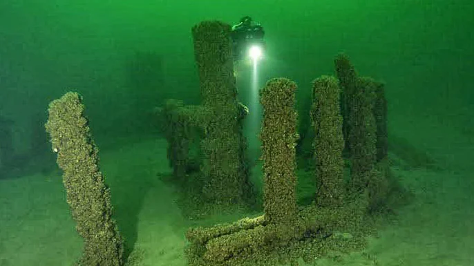
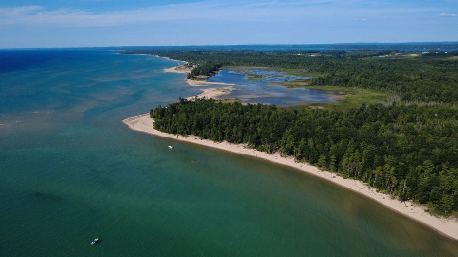
You have sonar running across northern Lake Michigan, testing equipment and mapping the bottom, when you suddenly see what looks like a ring of upright stones. That is exactly what a small research team reported in the late 2000s: a group of boulders arranged in a rough circle about 40 feet down, one of them apparently marked with what looked like a carved figure of a mammoth. To your eyes, it feels like something straight out of a documentary about ancient Europe, except you’re just a couple hundred miles from Chicago instead of Salisbury Plain. The image of those stones sitting in that cold, dark water is the kind of thing that sticks in your head long after you close the laptop.
When you ask what the official explanation is, you run into a wall of “maybes.” Some archaeologists point out that glacial activity can move and arrange boulders in strange patterns, and that sonar images can be deceiving. Others quietly admit that human-arranged stone features are known in the region, and that if that mammoth‑like carving is real, you could be looking at something thousands of years old. Yet no major agency has logged it as an authenticated archaeological site, and no detailed, peer‑reviewed survey has been pushed out to the public. So for now, you’re left with rumors, blurry images, and a spot on the lakebed that stubbornly refuses to become either just “rocks” or confirmed history.
The F‑89 Scorpion and the Teardrop Object in Lake Superior

Imagine sitting at a radar screen in 1953, watching a United States Air Force F‑89 jet interceptor merge with an unidentified radar return over Lake Superior – and then disappear. Decades later, a private group using side‑scan sonar said they had located an F‑89 on the lake bottom, and nearby, a smooth, teardrop‑shaped object with a strange slide mark leading to it. If you are at all drawn to Cold War mysteries, the image is haunting: a fighter jet lost while chasing an unknown object, apparently lying alongside a second unknown form in deep water. You can see why UFO enthusiasts still bring up this case whenever the Great Lakes come up.
Here’s where it gets even more frustrating. There’s no public, verified government report confirming that wreck as the missing F‑89, let alone a clear identification of the second object. Researchers have questioned the authenticity of some of the original claims and images, and the story of the discovery itself has turned tangled. Yet the core mystery – what exactly happened that night, and what exactly lies on the bottom in that area – has never been put to bed by any U.S. or Canadian agency. You are left with an almost cinematic scene frozen in time: a jet, a blip on a radar screen, and a sonar return that nobody in authority seems eager, or able, to define in plain language.
The Buried “Pole” Tied to a 300‑Year‑Old Shipwreck Mystery
Now picture yourself fixated on a centuries‑old mystery ship, a French vessel that supposedly vanished on the Great Lakes in the seventeenth century. Divers and sonar operators have long suspected a site in northern Lake Michigan, where timbers lie buried under layers of sand. During one expedition, instead of a full ship, the team recovered a single massive wooden pole from the bottom – a roughly 600‑pound timber that some believed might be part of that lost vessel. The temptation to see this as the smoking gun in a historical whodunnit is almost irresistible.
To settle the question, experts hauled the pole to a high‑end imaging facility and scanned it the way you might scan a patient in a hospital. Analysts tried to date it, study growth rings, and match it to known building methods. Some officials argued it was likely just a fishing‑gear stake from a pound‑net system once used widely in the Great Lakes; others remained convinced it could be a structural piece of a very old ship. Because cutting into it for definitive dating would be destructive, the object sits in a sort of limbo – documented, handled, even medically imaged, but not officially declared either a simple fishing relic or a priceless piece of early exploration. From your perspective, it’s like reading a detective novel where the author refuses to tell you whether the clue is real or a red herring.
The Unexplained High‑Rise “Ghost Ship” Shape in Lake Michigan
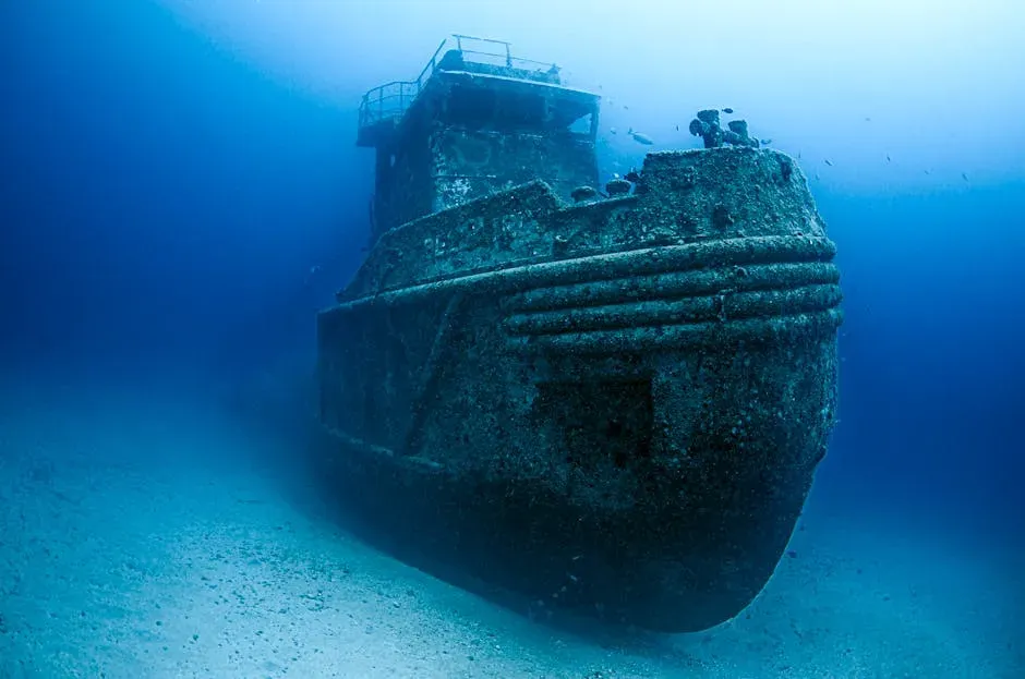
When you use modern sonar on the Great Lakes, you get used to seeing low lumps and vague shadows that turn out to be old wrecks or geological bumps. So when a seasoned shipwreck hunter reported an anomaly in Lake Michigan that shot 90 feet up from the lakebed – resting in around 300 feet of water – you can imagine how hard your eyebrows would jump. The sonar showed something tall and unexpected, a vertical shape in a place where nothing on standard charts suggested it should exist. At first glance, the data looked exactly like what you’d call a “ghost ship” if you were feeling dramatic.
The diver who went down found a wreck, but the object still doesn’t fit neatly into the catalog of identified, historically documented ships. It is old, tall, and sits like a lone skyscraper on an otherwise flat underwater plain, enough to fuel talk of hidden hazards and lost stories. No single agency rushed out a polished, definitive statement walking the public through every rivet and registry line, and the identity debate has dragged on in professional and hobby circles. From your vantage point, that leaves you with an eerie mental picture: a solitary vertical structure in the black water, mapped by sonar and photographed by divers, still waiting for someone with the authority and the paperwork to definitively name it.
The World War II Ordnance Field in Lake Ontario

If you fish or boat off Rochester, New York, you probably do not picture yourself drifting above a patch of lakebed seeded with old World War II materiel. Yet that is exactly what surveys and trawl catches revealed in parts of Lake Ontario: scattered military‑type debris resting in 75 to 180 feet of water. Researchers collected weapons‑related items accidentally while doing fish‑stock work, and later sonar and sediment studies confirmed that a whole field of dumped or jettisoned gear lay in the mud. You can almost see the outlines of crates, casings, and metal fragments under decades of sediment.
What no agency has fully, cleanly explained is the total origin story and precise inventory of that underwater dumping ground. Reports acknowledge that wartime and post‑war disposal likely played a role, but detailed, transparent documentation of every item and every dumping event is lacking. Instead, you get cautious language about “matériel,” potential contamination, and the need for monitoring. If you are looking for a neat official narrative that tells you exactly what went in, where, when, and why, you will not find it. The lakebed keeps its secrets, and the government’s language stays deliberately vague, leaving you to imagine half‑forgotten training missions and quiet late‑night disposal runs fading into the dark water.
The Submerged, Unidentified Mounds and Depressions
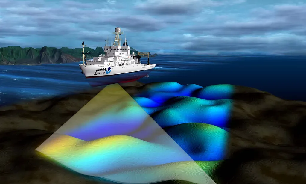
As mapping technology has improved, you have been handed a kind of X‑ray vision for the Great Lakes. Instead of blank blue on a map, multibeam sonar shows you ripples, mounds, pits, and scars on the lake floor in striking detail. Some of these shapes clearly come from known wrecks, old dredging activity, or natural geology. But then there are the others: large, isolated mounds and circular depressions in places that do not line up with known rock outcrops or documented ship losses. On a sonar screen, they show up as mysterious blips that beg for an explanation.
When you look for an official verdict, you mostly find educated guesses. Scientists mention glacial drop stones, underwater springs, ballast piles from old freighters, and even the signatures of groundwater seeps. None of these explanations has been firmly pinned to every odd feature, and many sites have never been physically inspected by divers or remotely operated vehicles because of depth, cost, or simple lack of time. So a quiet category of “unresolved anomalies” lingers in the data: real objects and shapes on the bottom, seen and mapped, but never properly labeled. From your seat, it feels like having a stack of unfiled photographs in a drawer – clearly something, not yet officially anything.
The Long‑Lost Hulls That Still Defy Exact Identification
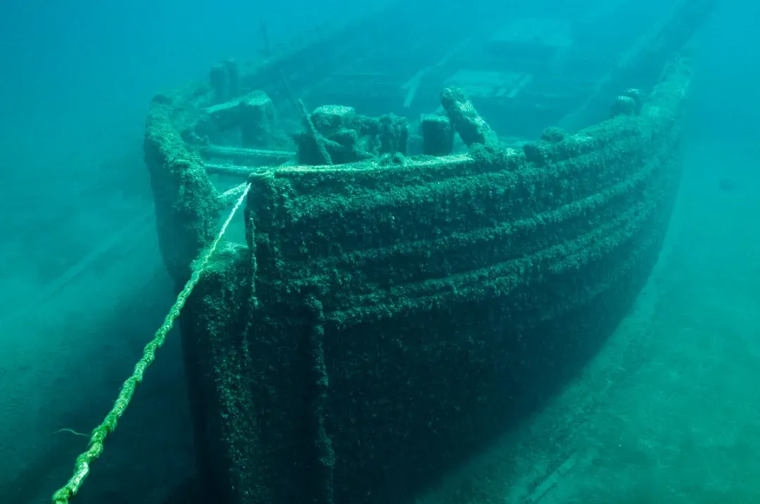
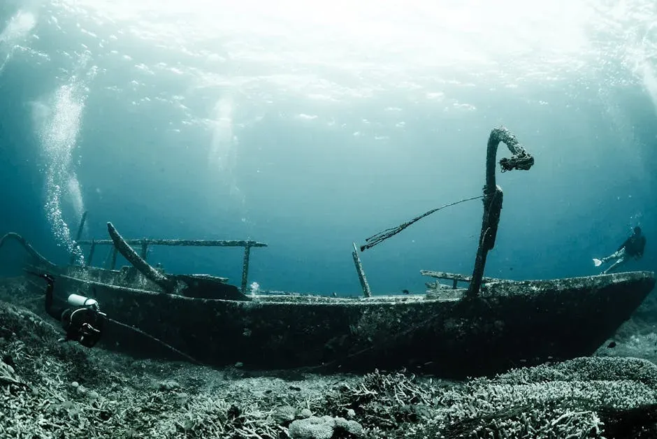
When you first hear that the Great Lakes may hold somewhere between roughly six thousand and ten thousand shipwrecks, you picture thousands of tragic, neatly documented stories waiting to be matched to hulls on the bottom. In reality, a surprising number of wrecks that have been located by sonar and cameras still do not have a clear identity. You might see a freighter lying intact, cabins preserved, cargo visible, yet no one has definitively tied it to a specific lost ship in the historical record. The water acts like a time capsule, but the labels are missing.
Agencies and sanctuaries do remarkable work solving many of these puzzles, yet there remains a backlog of unnamed hulls and partial structures. Sometimes the clues do not line up: dimensions are close but not exact, features have been altered by sinking and impact, and historical reports are vague or contradictory. This leaves certain wrecks in limbo – officially noted as “unidentified” in databases and reports, even when you can watch crisp video of them resting on the lakebed. You end up with the strange feeling that you know what these objects are in a general sense, yet you cannot point to a specific ship’s name and say with certainty: that one, that story, that final voyage.
The Scattered Aircraft Debris Fields With No Clear Flight Story

If you think only of ships when you picture the Great Lakes, you miss another unsettling category: aircraft. Over the decades, pieces of planes have turned up on the bottom – engines, fuselage sections, and twisted metal – without an immediately obvious match to a recorded crash. Given how many flights, training missions, and ferry runs have crossed these waters since the dawn of aviation, you can understand how some debris fields would be hard to trace. But that does not make it easier when you are staring at the sonar data.
Official incident logs, military records, and civil aviation databases are good but not perfect, especially when you go back into the wartime and early jet eras. In some cases, a diver finds a section of wing or a radial engine with no clear markings and no convenient entry in the archives. Agencies may catalog the site, note it as “likely aircraft,” and then stop short of issuing a confident identification. From your point of view, these scattered fields become open‑ended stories. You know something fell out of the sky and hit the water hard enough to end up here; you just do not know who was on board, what they were doing, or exactly which line in an old logbook corresponds to the fragments under your fins.
The Odd, Isolated Machinery and Industrial Artifacts

As you move across the lakebed with cameras and sonar, you periodically bump into something that looks like it was teleported in from a scrapyard. A single massive gear, a lone boiler, an engine block, or what appears to be the remains of heavy industrial equipment sits by itself in the mud, far from any obvious wreck site. There is no hull, no barge, no pile of associated debris – just one or two hulking objects that obviously came from human industry but do not come with a story attached. It is like walking through a forest and finding a single train wheel in the middle of a clearing.
Government and academic surveys tend to focus on clearly historical sites, known wrecks, or environmental hazards, so these orphaned artifacts sit at the edge of the official radar. Maybe they were cargo that broke loose in a storm, waste dumped illegally decades ago, or remnants of temporary construction projects long forgotten. Without detailed archival detective work, no one in authority can say for sure. That ambiguity leaves you with a low‑grade unease: you know humans put this heavy, complex object here, but you have to live with the fact that no agency is offering you a neat, cited explanation of how or why.
The Unresolved Sonar “Targets” That Vanish on Closer Look
Modern surveys of the Great Lakes kick up an endless list of sonar “targets” – spots where the return looks sharp enough, or strange enough, to merit a second look. If you sit in on this process, you quickly see a pattern: some targets are revisited and revealed to be clear wrecks, rocks, or pipes, while others more or less vanish when inspected at different angles or under different conditions. Every now and then, though, you encounter a target that stubbornly remains odd, defying simple classification but never quite getting the full investigative treatment needed for an official ruling.
Agencies and research groups have limited time, money, and equipment; they cannot chase every ghost on a screen. So some of those elusive returns stay trapped in reports and databases as “unresolved anomalies.” Maybe they are clusters of boulders, collapsed wreckage, or even artifacts partly buried in sediment. Because no one has gone down with a camera or a diver to settle the question, you are left with a strange limbo. The target exists, has coordinates, and may even have been logged years ago, but there is still no official word beyond something like “possibility of structure.” For you, that translates to knowing there is an object there – just not what kind of object, or how it fits into any bigger story.
The Suspected Prehistoric Shoreline Features
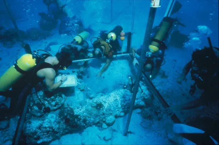
If you roll back the clock thousands of years, water levels in the Great Lakes region were not what they are today. Ancient shorelines, river mouths, and even human activity zones now lie underwater, hidden beneath silt and cold waves. When scientists began to map these areas with precision sonar, they picked up terraces, ridges, and clusters of stones that look suspiciously like old beaches or possible activity sites. Some of these features contain objects – stones in patterns, possible hearth remains, or unusual alignments – that could hint at very old human presence. To you, it feels like looking at a ghost version of the landscape you know.
The official stance on many of these underwater prehistoric candidates remains cautious. Agencies acknowledge that there may be submerged archaeological resources, but proving human involvement requires careful, costly work that often has not been done yet. So these places sit in reports under labels like “possible cultural feature” or “unconfirmed structure.” You are left with the tantalizing idea that tools, camps, or even ritual spaces might be sitting on the lakebed, seen but not yet fully understood. Until someone commits the resources to excavate and study them, they remain objects and arrangements that no government body is willing to definitively call either natural or cultural.
The Difficult‑to‑Explain Environmental Oddities on the Lakebed
When you think of mysterious objects, you probably picture solid things you can touch. But the Great Lakes also hide stranger, more organic oddities on their floors: clusters of unusual mounds, strange sediment textures, or fields of holes and pockmarks that do not immediately fit a neat geological or biological category. On sonar and in ROV footage, these areas can look almost like the surface of another planet, dotted with shapes that invite wild interpretation. If you are not careful, your imagination runs ahead of the science.
Scientists and agencies investigating these anomalies often lean toward natural explanations – gas seeps, burrowing organisms, erosion patterns, or groundwater upwelling through the lakebed. Yet even experts will admit that some specific sites are still being studied, and that data are not yet sufficient to say exactly what is going on. Those areas, in effect, become “unexplained objects” of another kind: not metal or stone, but patterns and formations that no one can fully decode. You are reminded that mystery does not always come in the shape of wreckage or machinery; sometimes it shows up as a landscape that refuses to behave the way you thought it should.
The Modern Debris That Arrived From the Sky
In recent years you have watched stories unfold about unidentified objects being tracked over North America and shot down over various regions, including above the Great Lakes. In at least one case, search teams were sent out into harsh conditions over Lake Huron to try to locate debris in deep, mid‑lake waters. Later documents acknowledged that material was recovered and examined, with officials eventually leaning toward mundane origins like commercial or research equipment. Yet despite these broad statements, you will not find a clean, public technical breakdown of every fragment that hit the water and came back up.
From your seat, that gap leaves another layer of ambiguity at the bottom of an already mysterious system. Somewhere, pieces of modern devices – balloons, sensors, electronics – may lie scattered on the lakebed, partially recovered or too small and dispersed to bother with. Agencies assert that nothing about them poses a national security threat, but they do not publish a museum‑grade catalog of artifacts either. So you are left with the knowledge that, even in the era of satellites and real‑time tracking, objects can fall into the Great Lakes, be partly recovered, and then disappear into a haze of classified memos and terse statements. The water, once again, keeps part of the story for itself.
Conclusion: Living With Mystery in the Inland Seas
When you pull all of these stories together – the stone circles, the lost jets, the buried poles, the nameless hulls, the shadowy mounds – you realize something humbling about the Great Lakes. For all our technology and paperwork, you are still dealing with bodies of water big enough, deep enough, and cold enough to protect their secrets for centuries. Government agencies can map them, regulate them, and investigate select anomalies, but they cannot chase every odd sonar blip or solve every historical riddle. That gap between what has been officially explained and what remains stubbornly ambiguous is where your imagination is free to wander, and where divers, historians, and scientists keep pushing for better answers.
At the same time, you are reminded that mystery here is not just about spooky legends or speculative theories. It is also about the very real limits of budgets, time, and hard evidence. Until someone commits the resources to revisit each of these objects and features with patient, methodical work, you will go on knowing that the Great Lakes hold confirmed things that no government agency has fully, publicly defined. Maybe that is part of their pull: these inland seas are close enough to touch, yet deep enough to act like another world entirely. If you ever get the chance to ride over their dark waters, will you picture what is officially charted – or will your mind drift toward the unexplained shapes resting quietly on the bottom?