You probably grew up hearing about the pyramids of Egypt or the Roman aqueducts, but almost nothing about the engineering marvels that rose in the Americas long before Europeans showed up. When you start looking closely, you realize entire cities, hydraulic empires, and precision-built monuments were already here, quietly rewriting what you think you know about technology and planning. In this tour, you are not just learning trivia; you are walking through a different mental map of the Americas. You will see how people with no steel, no wheels, and no written blueprints still pulled off feats that would challenge modern civil engineers. By the end, you may find yourself looking at deserts, mountains, and river valleys in a whole new way – less like empty land, and more like the remnants of a lost instruction manual for how to build in harmony with a tough landscape.
1. The Hohokam Super Canals of the Salt River Valley
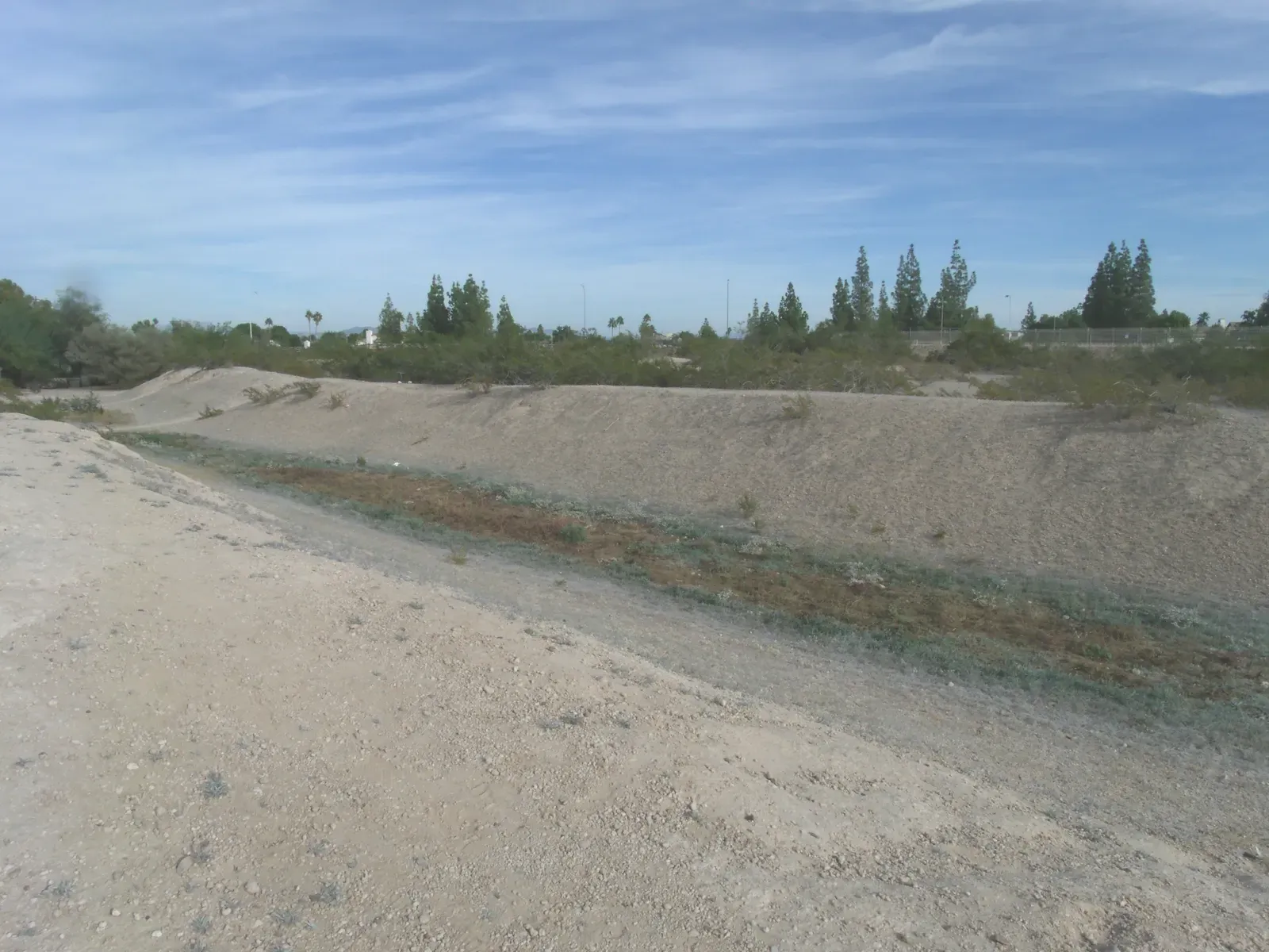
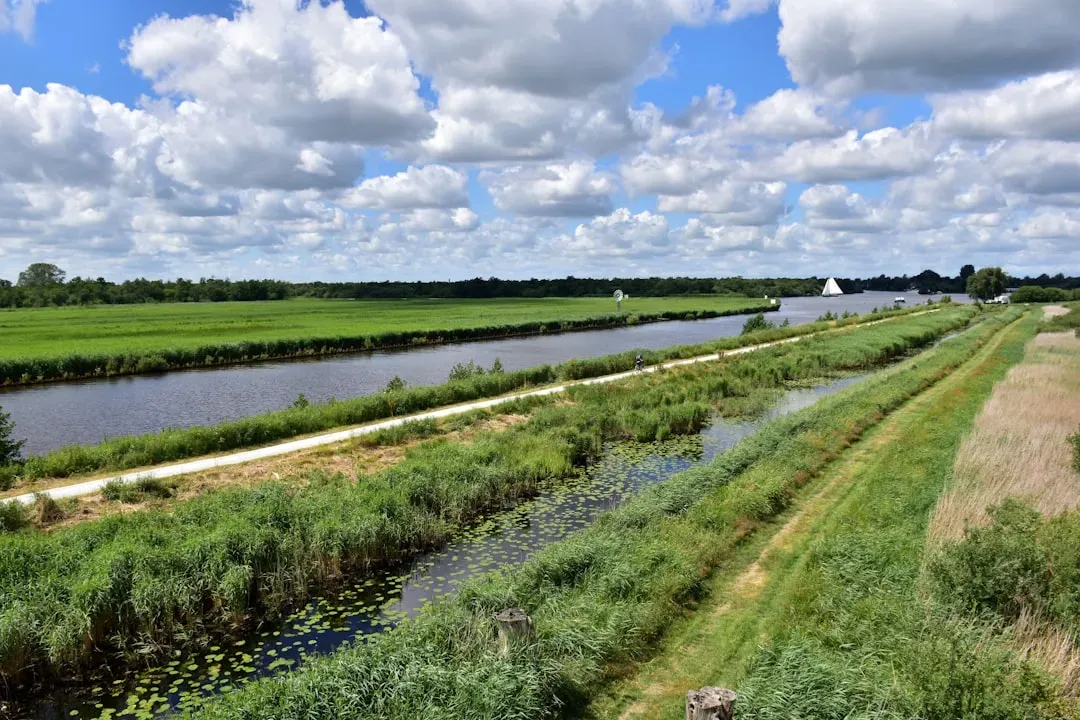
You might drive through Phoenix and see a modern desert city, but underneath its streets you are literally following the ghost lines of one of the largest canal systems in the pre‑industrial world. Between roughly the third and fifteenth centuries, Hohokam engineers carved more than hundreds of miles of main and lateral canals through hard desert soils to move river water across what is now the Salt and Gila River valleys. They did this without metal tools or draft animals, yet their network irrigated on the order of tens of thousands of acres of cropland, enough to support large, dense farming communities in a place where rainfall alone would never be enough. ([asce.org](https://www.asce.org/about-civil-engineering/history-and-heritage/historic-landmarks/hohokam-canal-system?utm_source=openai))
When you picture these canals, do not imagine little ditches; some main channels were more than ten feet deep and wide, carefully graded so water flowed steadily but did not erode the banks. Hohokam planners had to calculate slopes over miles, design headgates, and coordinate labor to maintain and periodically rebuild the system through floods and droughts. The fact that modern canals in Phoenix still follow many of their original alignments tells you how well they read the landscape the first time. ([visitphoenix.com](https://www.visitphoenix.com/stories/post/explore-the-phoenix-canals-your-guide-to-trails-maps-must-see-stops/?utm_source=openai))
2. Tiwanaku’s Hidden Drainage Labyrinth in the Bolivian Altiplano
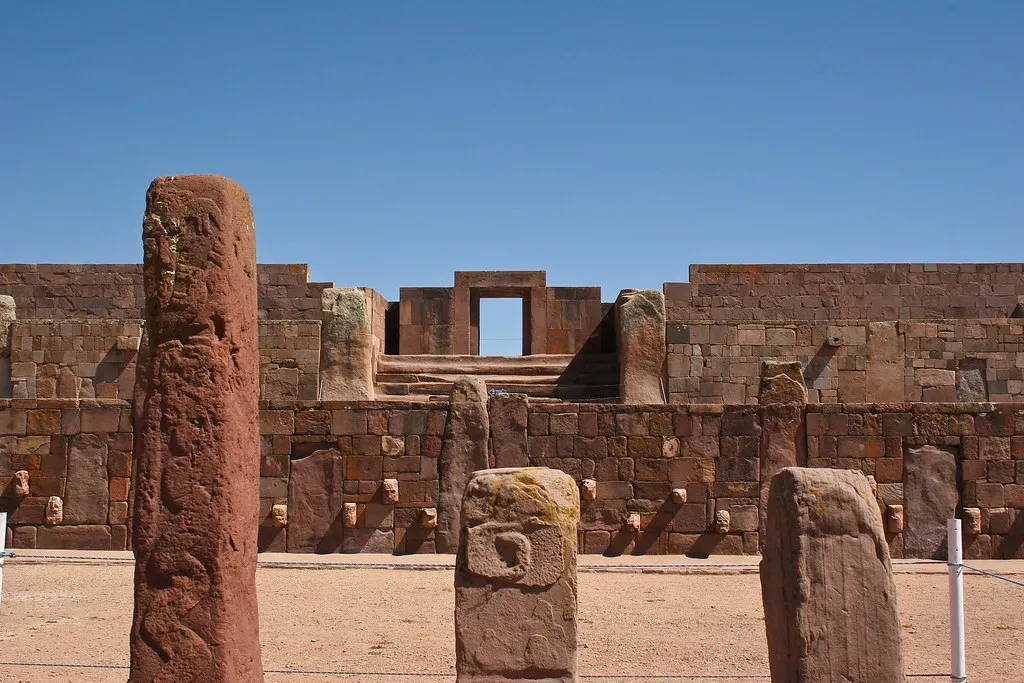
High on the windswept Altiplano near Lake Titicaca, you can walk across what looks like a silent stone city at Tiwanaku without realizing you are standing on top of an ancient plumbing diagram. The builders here did not just stack stones; they embedded a sophisticated drainage and sewage system beneath plazas and pyramids to control seasonal rains and groundwater. Channels ran inside structures like the Akapana pyramid and along the edges of sunken courts, carrying water away before it could destabilize the earth‑fill cores that held everything up. ([mdpi.com](https://www.mdpi.com/2073-4441/12/12/3562?utm_source=openai))
If you trace the paths archaeologists have mapped, you see that runoff, ritual water features, and even waste were directed into a perimeter channel and then toward the nearby Tiwanaku River. In other words, you are looking at a pre‑Columbian urban storm‑water and sanitation system designed at nearly four thousand meters above sea level. It is the kind of infrastructure you are used to hiding under modern cities, yet here it was conceived centuries before European engineers started worrying about underground sewers and structural waterproofing. ([mdpi.com](https://www.mdpi.com/2073-4441/12/12/3562?utm_source=openai))
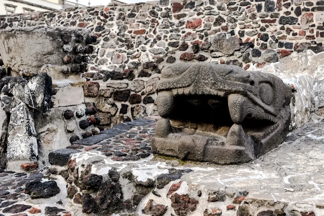
3. Puma Punku’s Precision‑Cut Stone Blocks
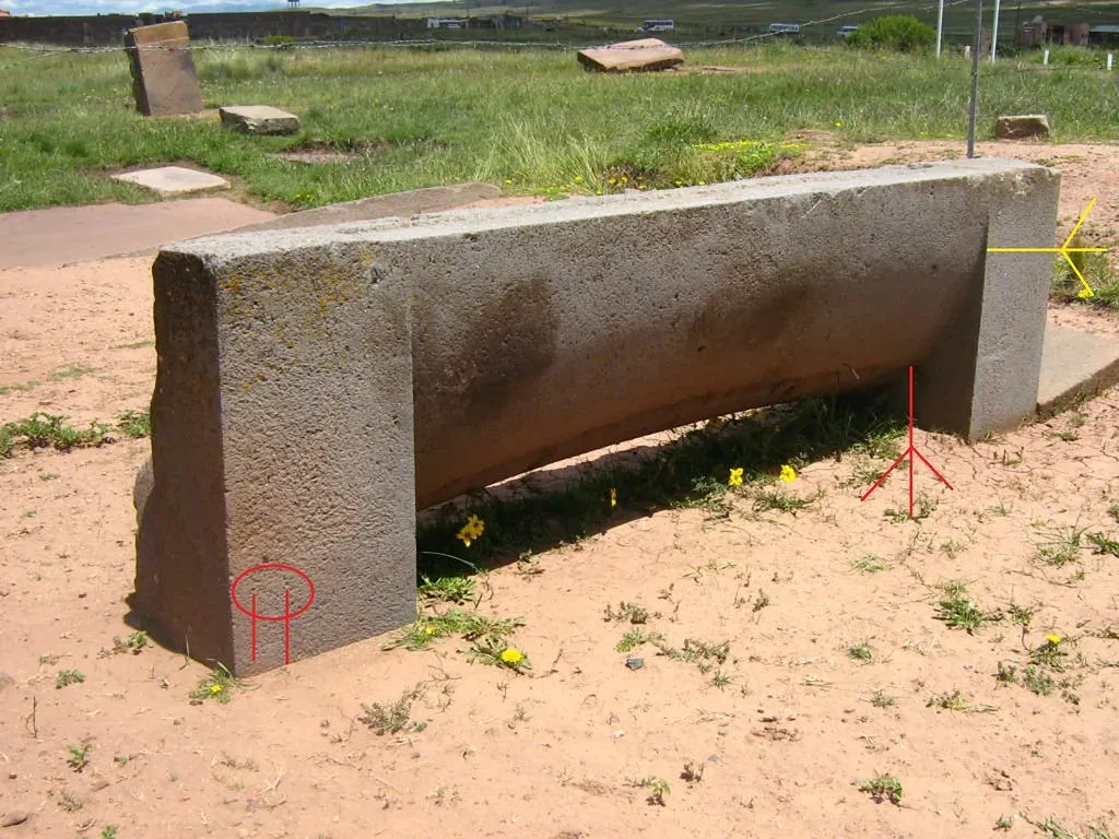
When you step into Puma Punku, a temple platform within the Tiwanaku complex, it almost feels like you have stumbled onto a stone machine shop left out in the open. Massive sandstone blocks and smaller andesite pieces were shaped into right angles, complex interlocking profiles, and near‑mirror‑flat faces. Some blocks fit together with such tight joints that you would have trouble sliding a knife blade between them, even after centuries of weathering. You are seeing the result of careful hammering, pecking, grinding, and polishing rather than any kind of exotic technology. ([en.wikipedia.org](https://en.wikipedia.org/wiki/Pumapunku?utm_source=openai))
The real engineering story here is not about fantasies of lost civilizations; it is about what you can do with patience, standardized measurements, and a deep understanding of stone. Andesite facing stones came from quarries across Lake Titicaca, roughly ninety kilometers away, which means Tiwanaku planners had to organize large‑scale quarrying, transport, and on‑site finishing. When you run your hand over one of those sharp internal corners carved into hard volcanic rock, you are feeling a design language that let builders create modular components long before the word “modular” existed. ([en.wikipedia.org](https://en.wikipedia.org/wiki/Pumapunku?utm_source=openai))
4. Cahokia’s Monks Mound and the Art of Building in Earth
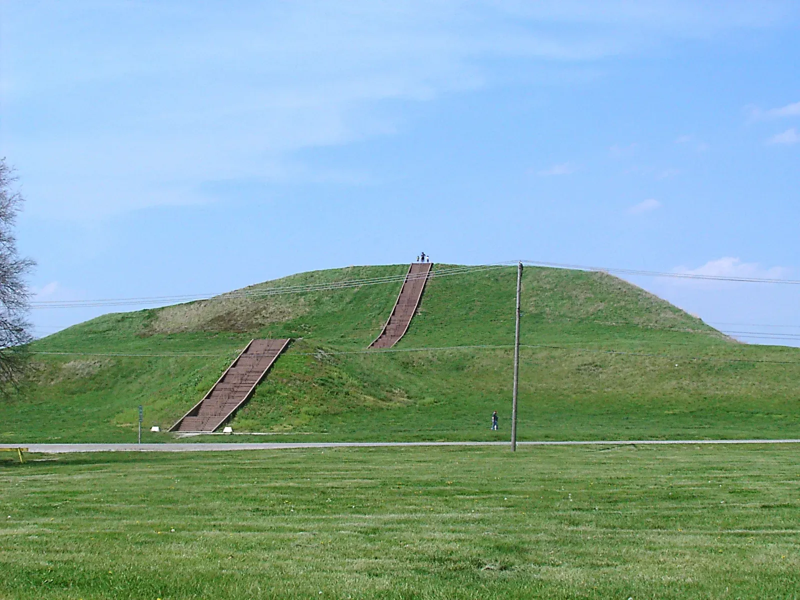
On the floodplain near present‑day St. Louis, you can stand at the base of Monks Mound and realize you are looking at a kind of earthen skyscraper. Rising about one hundred feet and covering nearly fourteen acres, this stepped platform is the largest pre‑Columbian earthwork in the Americas north of Mexico. It was not dumped in one go; you are seeing the result of many construction episodes where builders hauled and compacted different soils in carefully layered stages. The volume of earth moved runs into the tens of millions of cubic feet, a labor investment comparable to some Old World monuments. ([en.wikipedia.org](https://en.wikipedia.org/wiki/Cahokia?utm_source=openai))
If you could slice the mound open, you would see that it behaves less like a random pile and more like a dam or engineered embankment. Builders paid attention to drainage, choosing clays, silts, and sands in ways that let water shed off the surface instead of infiltrating and collapsing the core. At its peak, a large timber building sat on the summit, turning the mound into both an elevated stage for political and religious life and a statement of engineering control over a once‑undulating landscape. When you climb it today, you are walking up a machine made of dirt, tuned to resist time and weather. ([en.wikipedia.org](https://en.wikipedia.org/wiki/Monks_Mound?utm_source=openai))
5. The Leveled Grand Plaza and Cosmic Street Grid of Cahokia
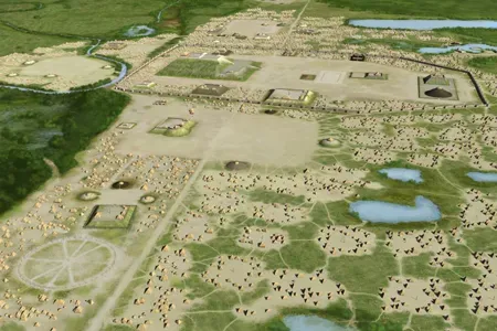
When you step out from Monks Mound into Cahokia’s Grand Plaza, it is easy to assume the smooth, flat ground is just a natural floodplain. Soil studies have shown the opposite: early builders leveled and filled a ridge‑and‑swale landscape to create a rectangular space of roughly fifty acres. To do that, they had to cut down high spots, move earth into low troughs, and smooth the whole surface to a degree of regularity where processions, markets, and rituals could unfold on stable, predictable ground. You are literally walking on a reshaped topography, like a giant engineered stage set. ([en.wikipedia.org](https://en.wikipedia.org/wiki/Cahokia?utm_source=openai))
Zoom out in your mind, and you see that this plaza is not isolated: it aligns with Monks Mound, other mounds, and causeways along cardinal directions. The city’s layout reflects a worldview where space, power, and the cosmos are wired together in a grid of meaning. When you compare this to modern urban planning, you notice familiar themes – zoning ceremonial centers, aligning major avenues, choreographing movement – except here they are being worked out with packed earth and wooden posts rather than asphalt and concrete. The engineering is not just physical; it is also social, organizing how thousands of people moved, gathered, and experienced their city. ([sciencenewstoday.org](https://www.sciencenewstoday.org/the-ceremonial-purpose-of-cahokias-mounds?utm_source=openai))
6. Cahokia’s Woodhenge: A Timber Observatory in the Midwest
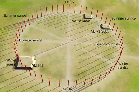
Walk west from Monks Mound and you reach a line of tall posts in a circle: a reconstruction of one of Cahokia’s so‑called woodhenges. These were large timber circles built and rebuilt over centuries, with posts carefully placed so that viewed from a central point, they marked the rising sun at solstices and equinoxes. In practical terms, you are standing inside a monumental solar calendar, one that helped time agricultural cycles and ceremonial events in a world without mechanical clocks. ([en.wikipedia.org](https://en.wikipedia.org/wiki/Cahokia_Woodhenge?utm_source=openai))
From an engineering angle, the trick here is precision in survey and layout using very simple tools. Creating a circle of posts that reliably tracks solar events year after year means you are measuring angles and sightlines across dozens of meters and then teaching others how to maintain or rebuild the structure as posts rot or shift. When you imagine doing all this with basic cords, sighting poles, and memory, you get a sense of just how seriously people in this city treated timekeeping, astronomy, and long‑term planning. The wood is gone, but the geometry you stand in still works. ([en.wikipedia.org](https://en.wikipedia.org/wiki/Cahokia_Woodhenge?utm_source=openai))
7. Andean Terraced Fields and Invisible Water Control
If you have ever seen photos of mountain slopes in the Andes that look like giant staircases, you are already familiar with one of the most quietly brilliant engineering systems in the Americas. Agricultural terraces built by societies including the Inca and their predecessors turned steep, erosion‑prone hillsides into stable, farmable steps. Each terrace wall holds back soil, while the stepped design slows runoff, letting water soak in rather than strip the slope bare. In some regions, these terraces climb thousands of feet in elevation, letting you grow different crops at different altitudes like bands on a vertical farm. ([mdpi.com](https://www.mdpi.com/2073-4441/12/12/3562?utm_source=openai))
What you do not see at first is the subsurface design: layers of larger stones, gravel, and soil inside many terraces act like a drainage and irrigation sponge. That layering helps keep roots from drowning in heavy rains and supplies stored moisture during dry spells. When you walk along one of these ancient stairways, you are moving through a hydrological system as much as a field. This is engineering aimed not at forcing the land to obey, but at tuning it so closely that the hillside itself becomes a living water‑management device. ([mdpi.com](https://www.mdpi.com/2073-4441/12/12/3562?utm_source=openai))
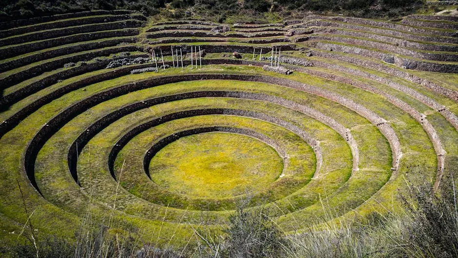
8. Raised Fields and Canals of the Lake Titicaca Basin
Around Lake Titicaca, you can still spot patterns of low, elongated mounds separated by narrow depressions, like ribs across the landscape. These are the remnants of raised fields – platforms for crops flanked by canals – built by pre‑Inca societies including the Tiwanaku culture. The concept is wonderfully simple and incredibly effective: crops grow on the slightly elevated beds, while water fills the intervening ditches. At night, the water releases heat it stored during the day, buffering crops against frost in this high‑altitude environment. You are seeing climate control embedded directly in landform. ([mdpi.com](https://www.mdpi.com/2073-4441/12/12/3562?utm_source=openai))
From an engineering standpoint, raised fields required you to understand local microclimates, soil behavior, and water levels season by season. Builders laid out long, parallel beds, sometimes in curving patterns tuned to slight slopes and natural drainage, and they maintained them by dredging canals and adding organic matter. It is the kind of low‑tech, high‑knowledge system that modern sustainable agriculture is rediscovering: instead of fighting cold, drought, or floods with massive external inputs, you re‑shape the ground so that the environment itself does more of the work. ([mdpi.com](https://www.mdpi.com/2073-4441/12/12/3562?utm_source=openai))
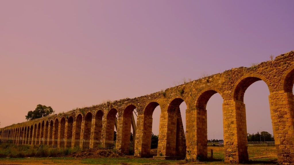
9. The Urban Hydraulic Landscape of Tenochtitlan
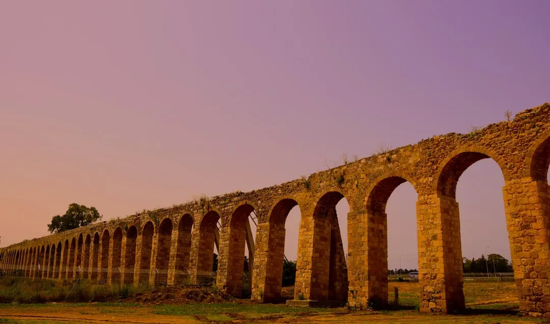
Picture yourself approaching the Aztec capital of Tenochtitlan in the early sixteenth century: a city rising out of a lake, laced with causeways, canals, and aqueducts. Built on an island in Lake Texcoco, this metropolis relied on a web of dikes and raised roads to control brackish water and connect it to the mainland. At the same time, freshwater aqueducts brought drinking water in from springs on the surrounding hills, crossing marshy zones on stone arcades. You are looking at an urban design where boats and pedestrians shared the same circulation network, weaving together transportation and water management. ([mdpi.com](https://www.mdpi.com/2073-4441/12/12/3562?utm_source=openai))
One of the most striking feats was the long dike that helped separate saltier central waters from fresher zones, protecting chinampa fields – raised beds built in shallow lake areas – from salinity. These man‑made agricultural islands, tied together with canals and living tree borders, turned wetland into reliable farmland. When you compare this to a modern city ringed with levees and elevated highways, you see echoes of the same thinking: protect your core, control your water levels, and use every possible surface for production or movement. The tragedy is that most of this system was dismantled or overwhelmed after conquest, leaving only fragments underneath Mexico City’s foundation. ([mdpi.com](https://www.mdpi.com/2073-4441/12/12/3562?utm_source=openai))
10. Nazca Puquios: Spiral Wells and Underground Aqueducts
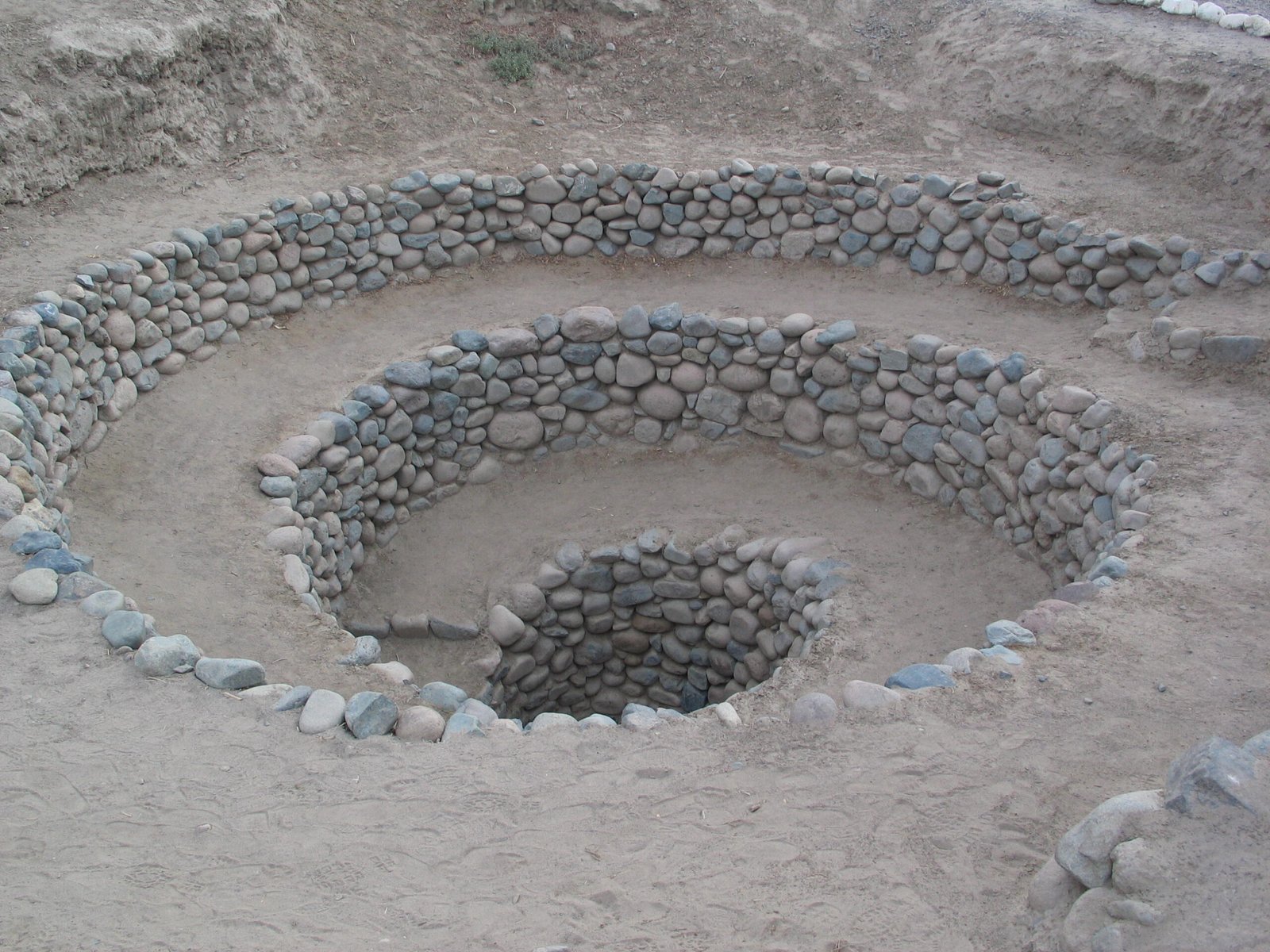
In the coastal deserts of southern Peru, you can peer down into a spiral of stone steps disappearing into the earth and realize you are looking at one of the cleverest water hacks in the ancient Americas. These structures, called puquios, are part of an underground aqueduct system built by the Nazca culture to tap and move groundwater. The spiraling ramps let you climb down to clean and maintain the channels, but they also help funnel wind into the tunnels, pushing air along and encouraging water to flow. It is a mix of geology, ventilation, and hydraulics wrapped into one elegant form. ([mdpi.com](https://www.mdpi.com/2073-4441/12/12/3562?utm_source=openai))
Imagine trying to farm or live in a place where rain is scarce and irregular, yet still finding ways to deliver reliable water year after year. To pull this off, Nazca engineers had to map subsurface water sources, follow impermeable layers, and choose slopes that kept water moving without eroding the tunnels. When you trace the paths of these channels from your bird’s‑eye view, you see how they stitched together wells, fields, and settlements into a single system. The spirals that look so artistic from above are actually maintenance and airflow devices you can still walk through today. ([mdpi.com](https://www.mdpi.com/2073-4441/12/12/3562?utm_source=openai))
Conclusion: Rethinking What You Call “Advanced”
As you move from desert canals to earthen pyramids, from stone‑cut observatories to underground aqueducts, a pattern starts to emerge: you are not looking at random curiosities, but at full‑blown engineering traditions that took landscapes as their starting point. These builders read slopes, soils, sun angles, and water tables the way an experienced mechanic reads the sound of an engine. They made mistakes, rebuilt, scaled up, and left behind systems that in many cases still influence modern cities and farms, even if most people have no idea. The silence around these places is less about their importance and more about whose stories you were taught to treat as “real” engineering history. ([asce.org](https://www.asce.org/about-civil-engineering/history-and-heritage/historic-landmarks/hohokam-canal-system?utm_source=openai))
If you take anything away from these ten forgotten wonders, let it be this: you are walking every day through a world that has been surveyed, shaped, and optimized by people who came long before you, often with tools far simpler than the ones in your pocket right now. The next time you cross a canal in Phoenix, climb a mound in the Midwest, or see an image of terraced hillsides in the Andes, you can choose to see more than scenery – you can see a quiet conversation between humans and hard environments that lasted for centuries. Which of these ancient solutions do you think you would trust more than the ones we are building today?