If you think the planet is already mapped, measured, and neatly understood, these places will shake that belief a little. Scattered across continents and oceans are geological puzzles that nag at geologists, defy simple explanations, and quietly suggest that Earth still keeps a few secrets to itself.
Some of these formations look like they were carved with tools, others seem to move on their own, and a few just break the rules of what rocks are supposed to do. We have theories, models, and educated guesses, but no airtight answers yet. Let’s walk through ten of the strangest places where the land itself seems to shrug and say, “figure me out.”
The Giant’s Causeway, Northern Ireland
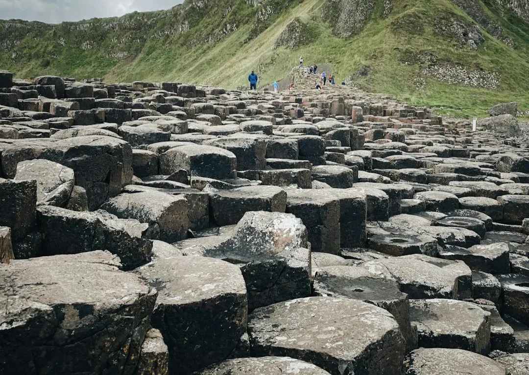
Standing on the Giant’s Causeway feels almost like walking on a broken honeycomb turned to stone. Tens of thousands of interlocking basalt columns, many of them nearly perfect hexagons, march from the cliffs down into the sea as if they were laid by some meticulous architect. The standard explanation points to ancient volcanic eruptions, cooling lava, and natural fracturing patterns, which all make sense on paper.
But the mystery lingers in the details: Why is the geometry here so strikingly regular, while other basalt fields around the world look rougher, less organized, almost chaotic by comparison? Researchers understand columnar jointing in a broad way, yet the precise conditions that produced such an enormous field of almost tile-like regularity are still debated. When you’re there in person, science feels correct but incomplete, like a story missing its last chapter.
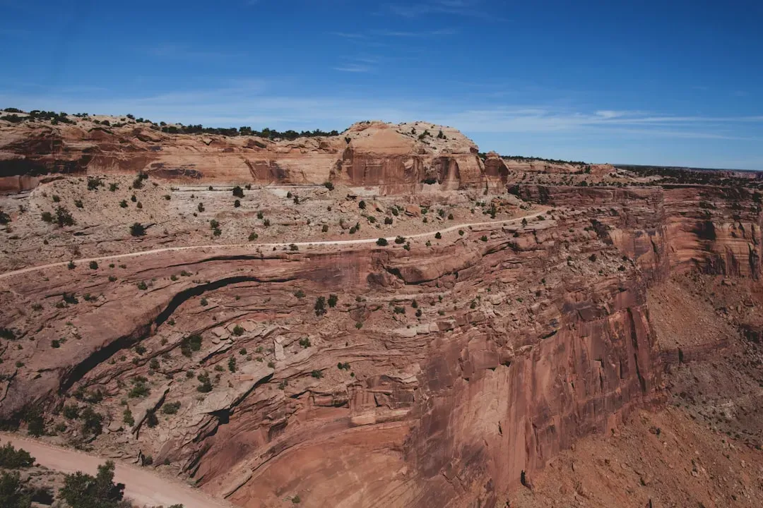
The Sailing Stones of Racetrack Playa, California
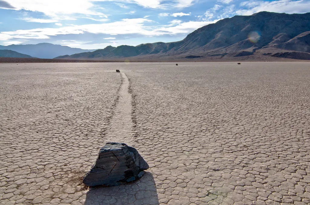
In Death Valley’s Racetrack Playa, heavy rocks leave long, winding trails across the dried lakebed, as if they’ve decided to go for a slow-motion walk. For decades, no one could catch them in the act, which made the whole thing feel like a prank the desert was playing on us. Theories ranged from powerful winds to magnetic fields, but nothing quite fit all the observations.
In recent years, time-lapse cameras and GPS tags have shown that thin sheets of ice, water, and wind can nudge the rocks along, sometimes just a few centimeters at a time. Yet even with that insight, there are still questions about why some stones travel far while others barely move, and why their paths can suddenly curve or stop. The broad mechanism is now clearer, but the fine-grained “why this rock, in this way, at this time” remains a quiet riddle baked into the cracked mud.
The Moeraki Boulders, New Zealand
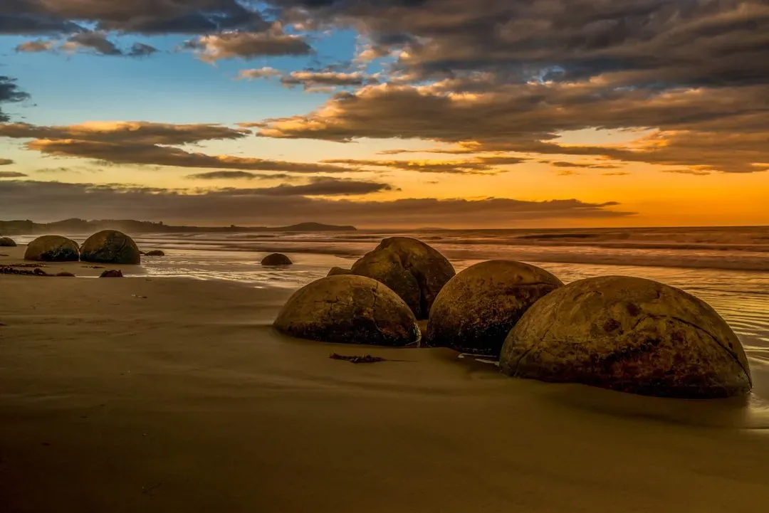
The Moeraki Boulders look like a collection of fossilized dragon eggs abandoned on a beach. These nearly spherical stones are massive, some as wide as a person is tall, and many are cracked in geometric patterns, as if the surface had been stitched together. Geologists classify them as concretions, minerals that slowly grew around a core within ancient sea floor sediments.
That explanation describes the process, but not the eerie precision. Why are some of them almost perfectly round, while similar concretions in other parts of the world are more irregular and scattered? What made this particular stretch of coast such a factory for giant stone marbles, all exposed in one place as the shoreline eroded? The chemistry is understood in principle, yet the scale, symmetry, and clustering still feel strangely deliberate.
The Stone Spheres of Costa Rica
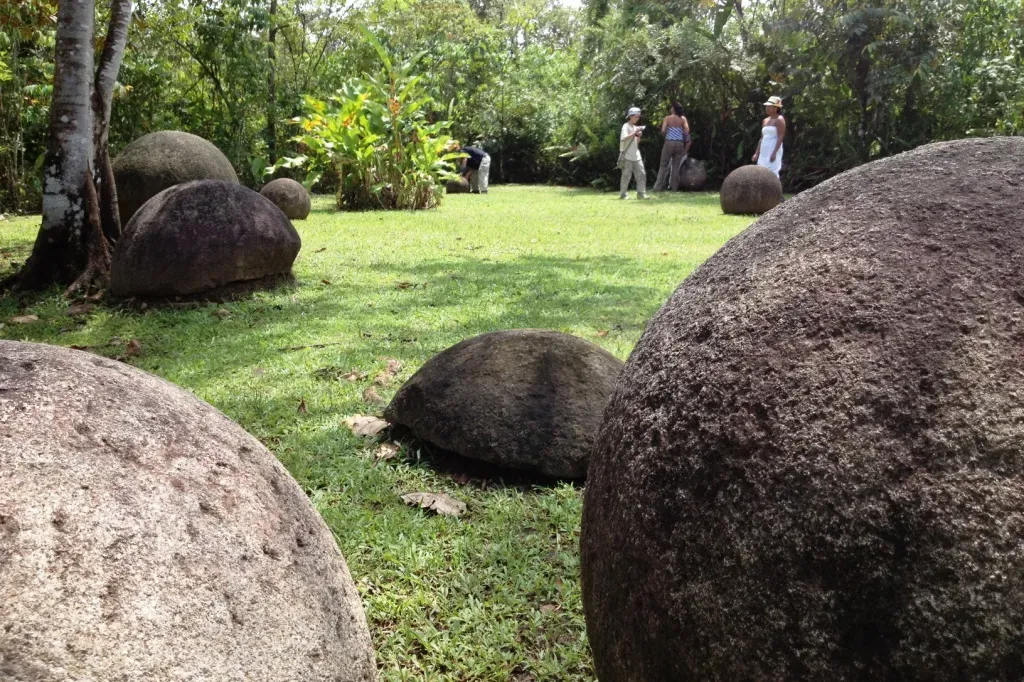
Deep in Costa Rica, scattered through fields, jungles, and even town plazas, you’ll find large stone spheres that look eerily manufactured. Many are impressively smooth and nearly perfectly round, ranging from the size of a bowling ball to those weighing many tons. They are made primarily of igneous rock like gabbro, which is tough to shape with even modern tools.
These spheres are technically archaeological artifacts, but their geology is equally puzzling. How exactly were these rocks quarried, transported, and sculpted so precisely, and why are they often found in clusters or aligned patterns? Weathering and natural processes can round stones, but not with this level of uniformity or in such specific, deliberate contexts. The stones sit at a crossroads where human intent and stubborn rock behavior blur together in ways that experts still argue about.
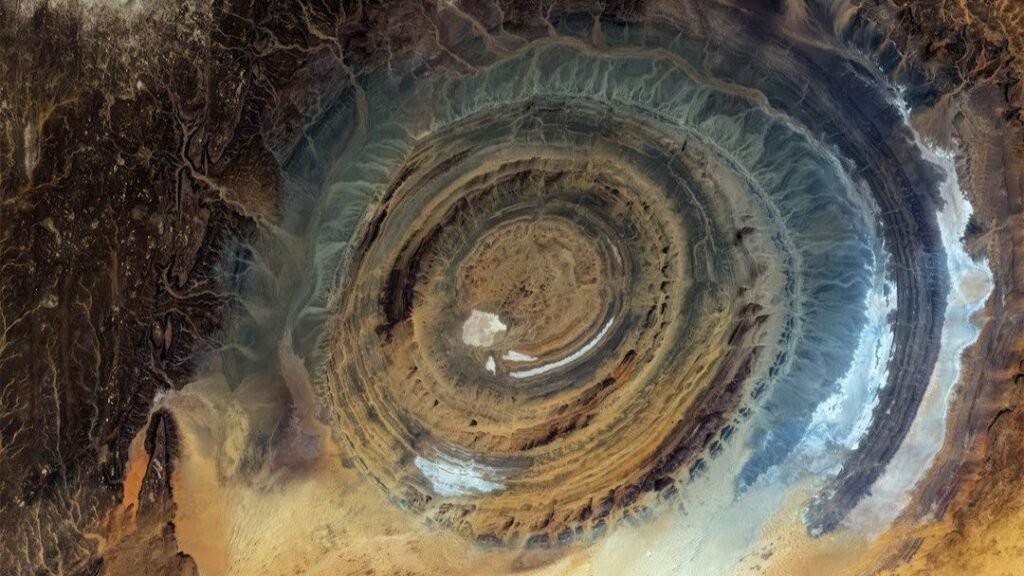
The Richat Structure (Eye of the Sahara), Mauritania
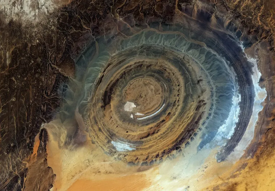
From the ground, the Richat Structure looks like a series of low, battered ridges in the Sahara Desert. From space, though, it jumps out as a massive bullseye: a series of nested circular rings about forty kilometers across, earning it the nickname “Eye of the Sahara.” Early on, some suspected a giant impact crater, but that theory has mostly fallen out of favor.
Current thinking leans toward a deeply eroded geologic dome, where layers of rock have been uplifted and then worn away to reveal concentric circles. The problem is that the symmetry is almost too neat, and some of the internal features do not fit comfortably with simple dome models. The structure also doesn’t match what you’d expect from a standard volcanic caldera. So we’re left with a huge, hypnotic whirl of rock that has a plausible outline of an explanation, but still more questions than certainties when you zoom in on the details.
The Hexagonal Columns of Reynisfjara and Svartifoss, Iceland
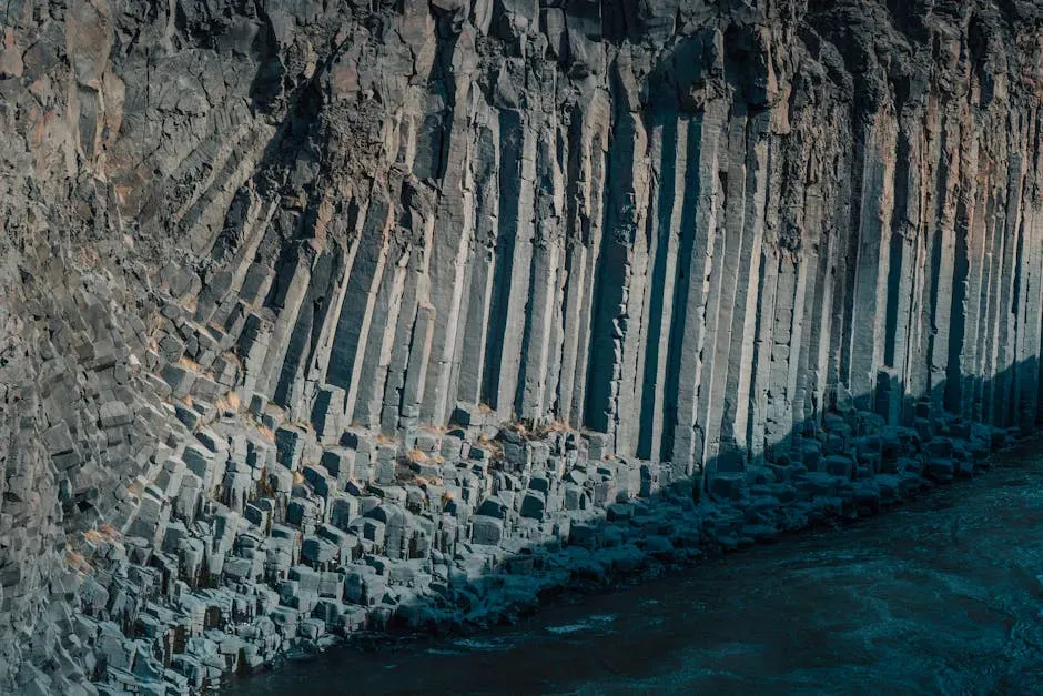
On Iceland’s black sand beaches and at the base of waterfalls like Svartifoss, tall basalt columns rise like organ pipes carved into the cliffs. Just like the Giant’s Causeway, these hexagonal pillars were formed by cooling lava, shrinking and cracking in geometric patterns. In Iceland’s harsh light, they look almost digital, as if someone rendered the coast in low-poly 3D.
Scientists broadly understand how symmetric fractures form as molten rock cools, but there’s still debate around why some flows form such well-ordered columns while others break into messy shards. The regularity in places like Reynisfjara seems almost excessive, given the chaotic nature of volcanic eruptions. Questions linger about the precise temperature gradients, cooling rates, and internal stresses needed to yield this kind of rock architecture. It feels like we know the recipe but haven’t fully nailed the instructions.
The Devil’s Tower, Wyoming, USA
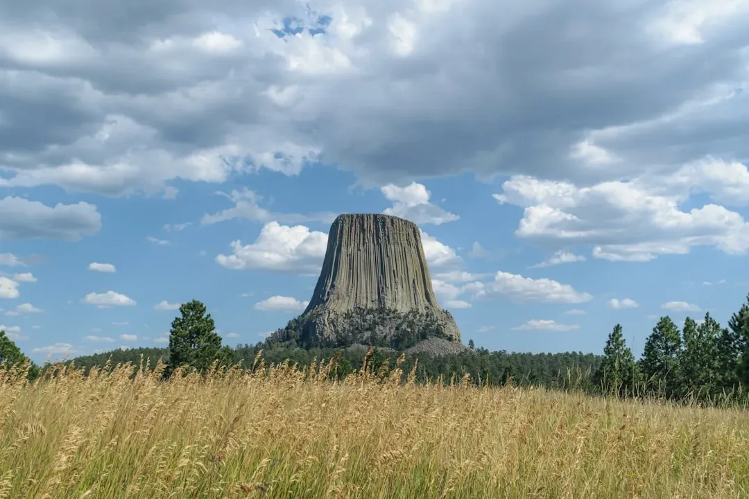
Devil’s Tower rises abruptly from the rolling landscape of Wyoming, a solitary monolith striped with vertical grooves. It’s a wall of rock that looks almost carved, the columns so straight you could mistake them for the remains of some lost stone fortress. Most geologists think it’s the core of an ancient volcanic system, with the surrounding softer rock eroded away over millions of years.
The catch is that the exact origin and shape of the magma body remain debated. Was it a volcanic plug, a laccolith, or something more unusual? And why did the cooling magma fracture into such extraordinarily tall, regular columns compared to similar intrusions elsewhere? The tower sits awkwardly between well-known categories, and no single model accounts neatly for both its form and its isolated presence on the landscape. It’s like a geological misfit that refuses to be fully classified.
The Baikal “Ice Rings” and Cracks, Siberia
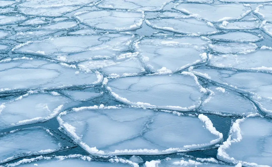
Lake Baikal in Siberia is already extreme: the deepest freshwater lake on Earth, holding a staggering share of the planet’s liquid surface freshwater. But in some winters, satellite images reveal something even stranger: enormous, nearly circular dark rings on the ice, sometimes many kilometers across. At ground level, locals also see surreal pressure ridges, jagged cracks, and bizarre ice formations that seem to appear overnight.
Researchers suspect these giant rings may be caused by upwelling warm water or gas emissions from the lake’s depths, weakening the ice in consistent patterns. Still, not every ring occurrence has a satisfying, measured explanation, and the timing and distribution are irregular enough to raise new questions each season. The lake sits along a major rift zone and over deep faults, hinting that a complex interplay of tectonics, hydrothermal activity, and climate might be involved. For now, Baikal keeps teasing scientists with massive circles that refuse to be fully predictable.
The Fairy Circles of Namibia and Western Australia
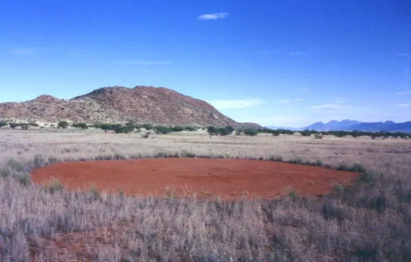
From the air, parts of the Namib Desert and remote areas of Western Australia look like someone scattered coins over the sand, then removed the coins and left only the outlines. These are fairy circles: strangely regular bare patches, surrounded by rings of vegetation, repeating across the landscape in almost hexagonal patterns. They can span just a few meters or stretch much wider, and they can persist for decades.
Different studies have proposed competing explanations, from termite colonies engineering the soil, to plants self-organizing as they compete for scarce water. Some data support both theories in different regions, which complicates the story instead of tidying it up. What’s still unsettled is why the patterns lock into those stable, near-hexagonal arrangements reminiscent of bubbles or crystals. It’s a reminder that even relatively soft materials like sand and plants can organize themselves like a kind of living geology that we do not fully grasp.
The Underwater Yonaguni Structures, Japan
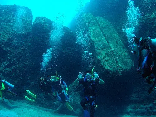
Off the coast of Yonaguni, a Japanese island, divers have found underwater terraces, steps, and flat surfaces that look suspiciously like ruins. Huge stone features resemble platforms, ramps, and sharp-edged blocks, all about twenty to thirty meters beneath the surface. Some observers argue these shapes are natural rock formations sculpted by currents and waves acting on layered sandstone.
Others insist that the right angles, flat planes, and what appear to be aligned features go beyond what random erosion usually produces. The central geological puzzle is whether these are simply jointed sedimentary rocks fractured along natural planes, or if human modification exploited those planes in the distant past. Without definitive artifacts built into the stone, the debate loops between geology and archaeology. The rocks remain there either way, quietly daring both fields to make a conclusive call.
Conclusion: A Planet That Still Surprises Us
Looking at these formations together, it’s striking how often science has most of the picture, but not all of the edges colored in. We understand lava cooling, erosion, ice movement, and tectonic uplift, but when you zoom in on specific places, things get messy and stubbornly individual. Simple diagrams in textbooks start to feel a little too neat compared to what the real Earth does in the wild.
Some mysteries will probably shrink as new data, better models, and long-term observations accumulate, but it’s unlikely they’ll all vanish. There will always be some outcrop, some cliff, some crater, or some lonely tower of rock where the explanations don’t quite line up. And honestly, that’s part of what makes this planet worth paying attention to: the feeling that we’re still only partly fluent in the language of stone. Which of these puzzles would you most want to stand in front of and try to read for yourself?