America is one of the few places on Earth where you can stand at the edge of a canyon billions of years in the making, hike across a landscape that was once a roaring sea, and feel the ground literally tremble beneath a sleeping giant. The sheer diversity of geological forces that have shaped this continent is, honestly, difficult to overstate. Volcanoes, glaciers, rivers, tectonic collisions, and relentless erosion have all had their turn at sculpting the terrain you see today.
What makes these landscapes so captivating is not just their scale but their stories. Every ridge, spire, and cavern is a chapter in the longest book ever written. You do not need a geology degree to feel the weight of deep time standing at the rim of the Grand Canyon or staring up at the haunting columns of Devils Tower. You just need to look. Let’s dive in.
The Grand Canyon: Earth’s Autobiography Written in Stone
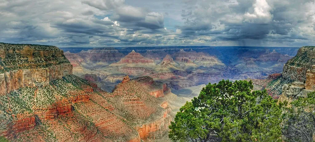
Here is something that might genuinely stop you in your tracks: when you stand at the rim of the Grand Canyon, the oldest rocks visible at the very bottom formed nearly two billion years ago. The major geologic exposures in the Grand Canyon range in age from the two-billion-year-old Vishnu Schist at the bottom of the Inner Gorge to the 270-million-year-old Kaibab Limestone on the Rim. That means you are looking at a living timeline stretching across nearly half of Earth’s entire existence, all in a single glance.
The canyon itself has formed much more recently than the deposition of its rock layers, only about five million years ago, as opposed to the rocks themselves, the youngest of which are a little less than 300 million years old. Think about that: the canyon is the newcomer here. This awe-inspiring chasm, carved by the Colorado River, exposes nearly two billion years of Earth’s history, and with its layers of red, orange, and ochre rock, it provides a living timeline of Earth’s geological events, from ancient seas and volcanic activity to uplift and erosion.
In the Grand Canyon, there are clear horizontal layers of different rocks that provide information about where, when, and how they were deposited, long before the canyon was even carved. It is essentially a 277-mile-long library, with each stratum a different chapter. Most of the fossils found in the Paleozoic layers are ocean-dwelling creatures, telling us that the area now in the middle of Arizona was once a sea. That fact alone is worth sitting with for a moment. Arizona. Once a sea.
Yellowstone: The Sleeping Giant Beneath Your Feet
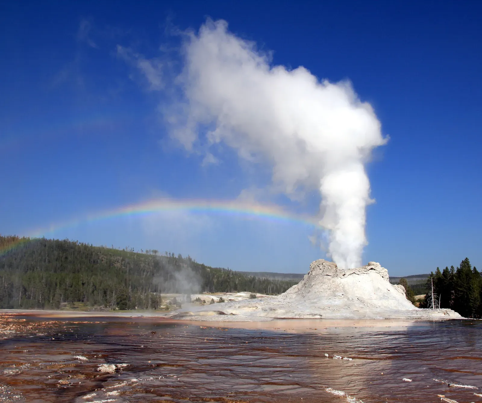
A huge reservoir of magma remains beneath the surface, and it is this subterranean supervolcano that makes Yellowstone one of the planet’s most geologically dynamic areas. You are not just visiting a park when you go to Yellowstone. You are walking directly on top of one of the most powerful volcanic systems in the world. Let’s be real, that is a very different kind of road trip.
Three extremely large explosive eruptions have occurred at Yellowstone in the past 2.1 million years. Molten rock rising from deep within the Earth produced three cataclysmic eruptions more powerful than any in the world’s recorded history, with the first caldera-forming eruption occurring about 2.1 million years ago. The scale of destruction is staggering. The Yellowstone hotspot has actually produced three calderas in the Yellowstone region, the youngest of which is nearly 80 kilometers long and 50 kilometers wide.
Yellowstone contains over half of the 1,000 or so known geysers in the world, including Steamboat, the world’s tallest geyser. The park sits inside an ancient volcanic caldera with magma, in some places only a few miles underground, powering its famous geysers, hot springs, fumaroles, and mud pots, where super-heated water trapped in underground channels sends bubbles of steam upward which eventually lifts the water and causes the geyser to overflow. It is genuinely volcanic theatre playing out in slow motion, every single day.
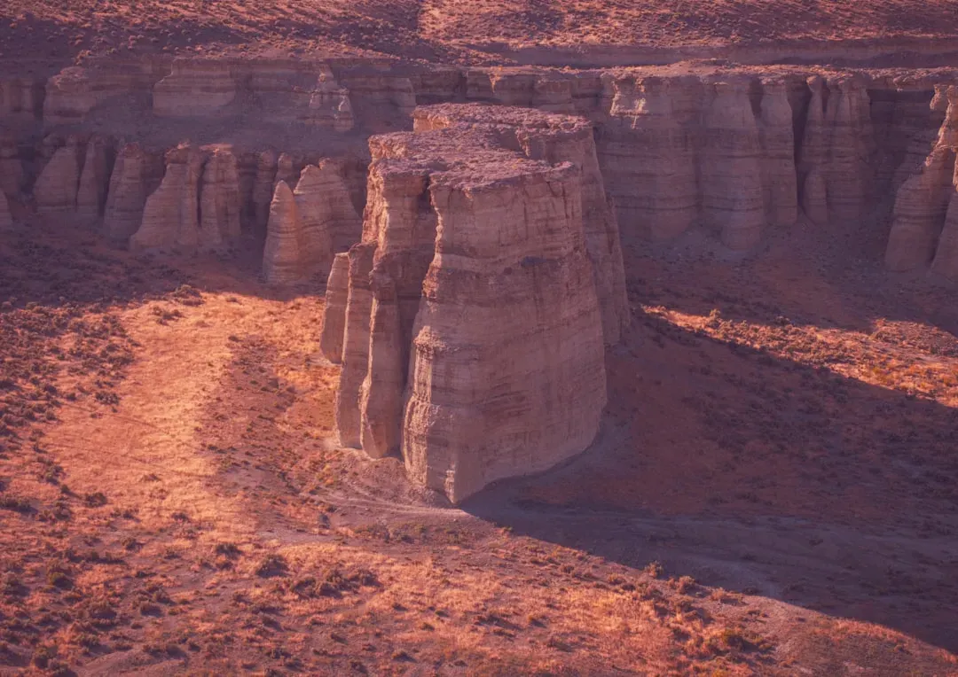
Bryce Canyon: Where Ice Sculpts Stone Into Armies of Spires
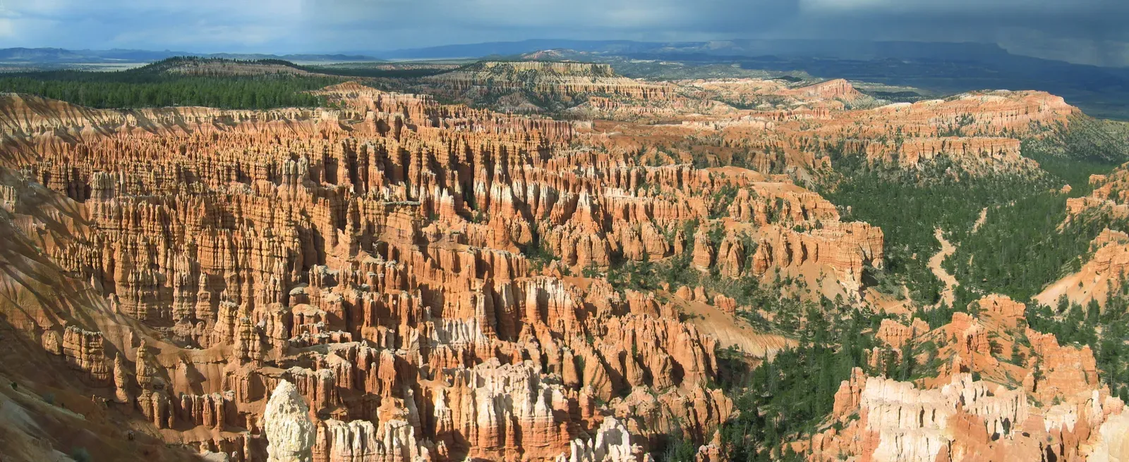
When you arrive at Bryce Canyon and gaze across the amphitheater for the first time, the scene feels almost unreal. Thousands of fiery orange spires rise in clusters, catching the sunlight in shades of pink, red, and gold. The formations seem playful, almost whimsical, yet they are the result of slow and relentless natural forces working over millions of years. These striking rock towers are called hoodoos, and they are the hallmark of Bryce Canyon.
Here is the thing about hoodoos: they are the result of an almost perfect storm of geological conditions. Bryce Canyon is in a “goldilocks zone” in terms of elevation. At a maximum of 9,115 feet above sea level, Bryce Canyon reaches both above and below freezing temperatures in the same night more than half of the days of the year, and this is crucial to creating the hoodoos. The primary force behind the formations is frost wedging, which occurs when rain or melting snow seeps into the limestone’s crevices and freezes. The expanding ice widens the vertical joint planes found in the Pink Member of the Claron Formation, with freeze and thaw cycles occurring hundreds of times each year, constantly changing the shape of the formations.
In the case of Bryce Canyon, the hoodoos erode at a rate of 2 to 4 feet every 100 years. They are vanishing, slowly. Bryce Canyon is home to the highest concentration of hoodoo formations anywhere on Earth. So it is worth seeing them while they are still standing, which in geological terms, is only briefly.
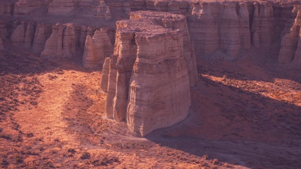
Devils Tower: The Volcanic Intruder That Outlasted Everything Around It
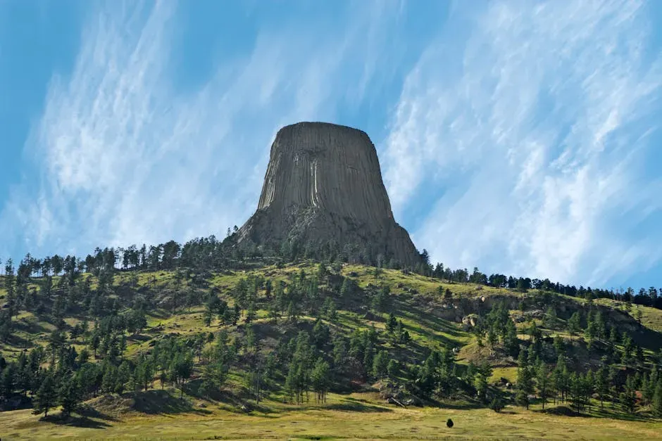
When you drive through the rolling ranch lands of northeastern Wyoming and Devils Tower suddenly rises before you, your brain genuinely struggles to process it. How did this solitary 867-foot column of lava rock end up in the middle of rolling forest and ranch land? Towering above the treetops, it looks as if it had been dropped from space or pushed skyward by some great underground force. The real story is even more interesting.
For roughly 95 percent of its existence, the entire block lived belowground, formed by molten lava that welled up into a layer of sedimentary rock 50 million years ago. Starting about 1 to 2 million years ago, rain and snowmelt slowly washed away the surrounding sandstone, siltstone, and shale, leaving the much sturdier mass behind. Its unique appearance, with vertical columns and hexagonal patterns, sets it apart from other geologic formations in the region. These columns were formed by the slow cooling and solidification of molten rock, followed by millions of years of erosion that stripped away the softer surrounding rock layers.
Sacred to many Native American tribes, it is central to myths such as the Kiowa legend of seven sisters saved from a bear by the tower’s divine formation. Designated as the first U.S. national monument by President Theodore Roosevelt in 1906, Devils Tower remains a popular climbing destination and a spiritual site. Science and spirituality have been converging here for a very long time, and honestly, standing at its base, you can understand exactly why.
Crater Lake: Born From Catastrophe, Filled by Sky
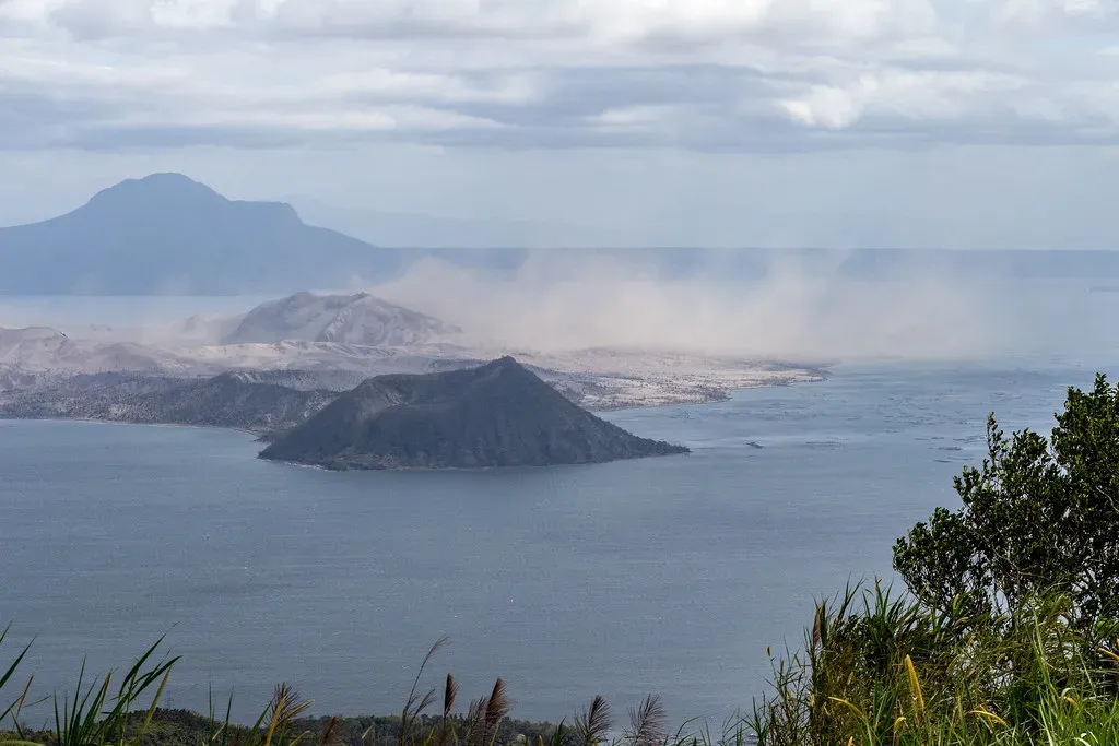
Crater Lake should not exist. Or rather, it only exists because of one of the most violent geological events in North American history. Crater Lake partially fills a type of volcanic depression called a caldera that formed by the collapse of a 3,700-meter volcano known as Mount Mazama during an enormous eruption approximately 7,700 years ago. In other words, you are gazing into the throat of a collapsed mountain.
About 7,700 years ago, Mount Mazama was the site of a tremendous eruption whose ash covered much of western North America. Mazama ash is even found in sediment cores collected from the floor of Yellowstone Lake. The top of the volcano collapsed into the emptied magma chamber, leaving a large surface depression that eventually filled with rainwater and became what we know today as Crater Lake. It is, in the most literal sense, a lake made from the sky.
Crater Lake in Oregon is the deepest lake in the United States, formed around 7,700 years ago when Mount Mazama erupted and collapsed, and its pristine blue waters are fed solely by rain and snow, making it one of the clearest lakes in the world. Visitors are drawn to its serenity and hiking trails, where they can see Wizard Island, a volcanic cone that rises from the lake’s surface. A volcano within a collapsed volcano, sitting at the bottom of a lake. You simply cannot make this stuff up.
The Badlands: An Alien Terrain Built From Ash and Ancient Bone
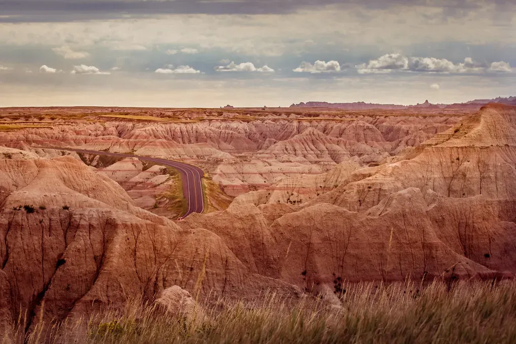
The Badlands of South Dakota look less like Earth and more like a painter’s nightmare. The Badlands contain some of the world’s most bizarre and alien-looking landscapes, classic examples of badland topography. The poorly consolidated bedrock consisting of loose sediment and volcanic ash is quickly eroded by infrequent rainstorms, resulting in mud mounds, spires, and ridges that resemble miniature mountain ranges. Walk through them and you feel genuinely disoriented, like the planet itself is performing an art installation.
The lower strata of brown and gray clay and shale date from the time of the dinosaurs, which explains the abundant fossils, including remains of Tyrannosaurus rex and Triceratops, discovered at the park. The upper layer, a younger and denser sandstone in shades of yellow and orange, erodes more slowly than the older rock below, an imbalance that gives the sculptured scenery a peculiar character. So when you look at the Badlands, you are seeing two completely different geological eras stacked on top of each other, separated by tens of millions of years of Earth history. That layered drama is written directly into the rock face, plain as day.
Mammoth Cave: The Largest Cave System in the World
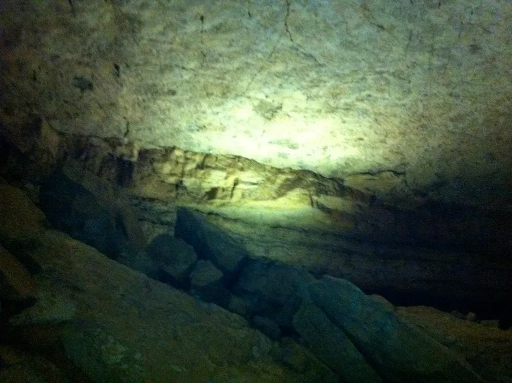
Most geological wonders demand you look up or out. Mammoth Cave asks you to look down, and then keep going. Holding the title as the longest cave system in the world, Mammoth Cave has more than 400 miles of explored passages. This limestone cave was carved by acidic groundwater that dissolved the rock over millions of years, creating vast caverns and delicate otherworldly formations. With stalactites, stalagmites, and gypsum flowers decorating its halls, Mammoth Cave is both a geological wonder and a portal to the mysterious underground world.
Think of it like this: Mammoth Cave is what happens when slightly acidic water gets millions of years to do exactly what it wants with limestone. The result is essentially a cathedral system stretching the length of a small country, hidden entirely underground. The park contains more than 100 known caves, including the nation’s deepest limestone cave at 1,604 feet and third longest. Carlsbad Cavern, with one of the world’s largest underground chambers, displays an amazing array of cave and karst features, and rising sulfur-rich fluids mixed with fresh groundwater to form sulfuric acid, which is responsible for the formation of this cave system. The chemistry that built these rooms is as wild as the rooms themselves.
The Rocky Mountains: When Tectonic Plates Throw Punches
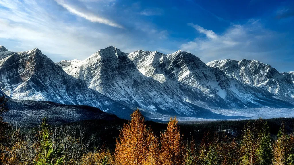
The Rocky Mountains feel permanent, eternal even, the kind of thing you assume simply always existed. The geological reality is far more violent. The rocks of an older mountain range were reformed into the Rocky Mountains, which took shape during a period of intense plate tectonic activity that formed much of the rugged landscape of the western United States. Three major mountain-building episodes reshaped the west from about 170 to 40 million years ago, spanning the Jurassic to Cenozoic periods. Imagine three separate collisions, each one rearranging a continent.
The Rockies form a majestic mountain barrier that stretches from Canada through central New Mexico. Though formidable, a look at the topography reveals a discontinuous series of mountain ranges with distinct geological origins. The rocks making up the mountains were formed before the mountains were raised, and the cores of the mountain ranges are in most places formed of pieces of continental crust that are over one billion years old. It is a humbling thought: the rock you are touching when you grab a handhold on a Rocky Mountain trail may have been forged before complex life even existed on this planet.
Conclusion: Reading the Land Beneath Your Feet
America’s geological wonders are more than scenic destinations. They are time machines, each one offering a window into forces so vast and ancient they make human history feel like a brief afternoon. From the two-billion-year-old schist at the base of the Grand Canyon to the living geothermal system bubbling under Yellowstone, the continent you live on is a work in progress, always has been, always will be.
What I find most striking is this: these landscapes were not designed for our appreciation. They were shaped by blind, indifferent forces over timescales we can barely conceive. Yet they inspire wonder, reverence, and genuine awe in virtually every person who encounters them. That says something profound about both the Earth and about us.
Next time you stand on a patch of American ground, consider what might be happening one mile directly beneath your feet. The planet has been extraordinarily busy for a very long time, and it is nowhere near finished. What would you have guessed was sleeping under Yellowstone before you knew the truth?