Earth has a habit of outdoing itself. You think you’ve seen it all – the rolling hills, the sea cliffs, the pine forests – and then the planet casually reveals a landscape so outrageous it makes your jaw drop. Neon-colored acid pools. Stone forests. Salt flats that mirror the sky. Formations so eerily perfect they seem engineered rather than grown.
The truth is, you don’t need a spaceship to feel like you’ve left Earth. You just need to know where to look. These eight geological formations are so bizarre, so breathtaking, and so fundamentally alien that they’ll make you question everything you thought you knew about the planet you’re standing on. Be ready to be surprised.
1. The Danakil Depression, Ethiopia – Earth’s Own Surface of Mars
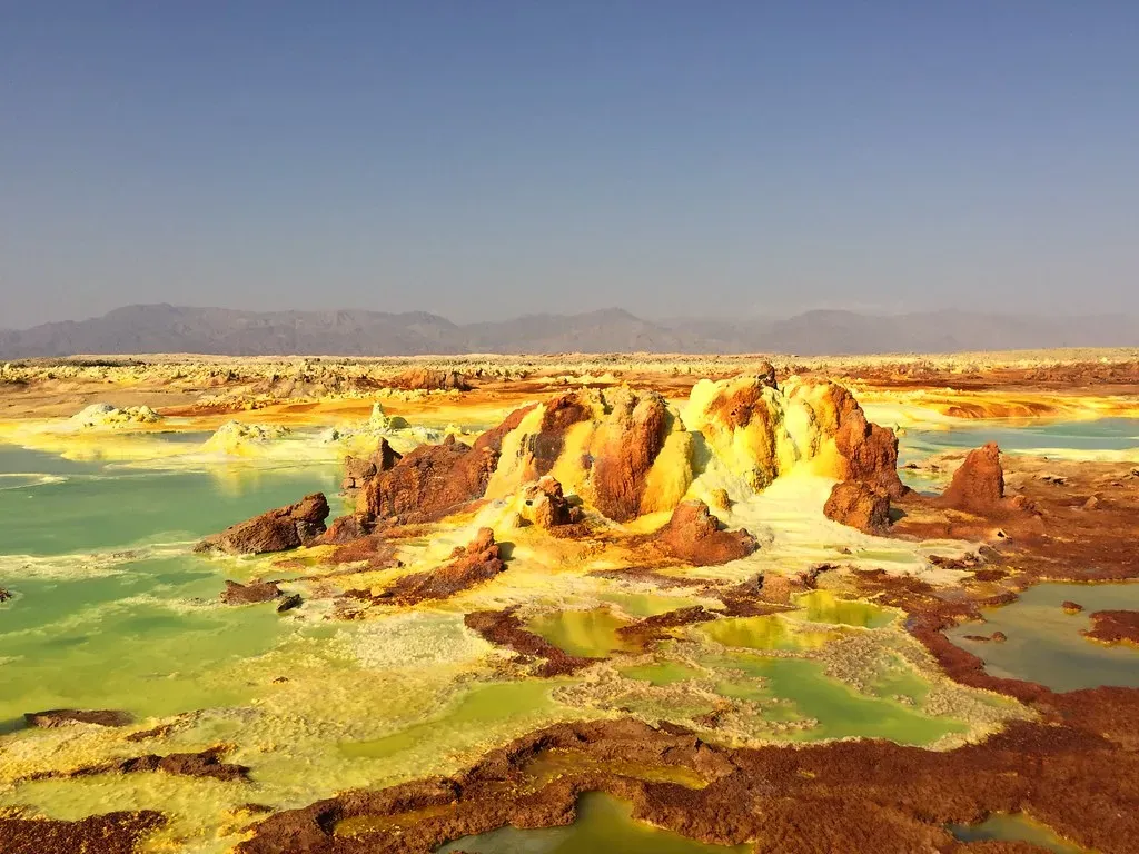
Let’s be real – if you were dropped blindfolded into the Danakil Depression and told you were on Mars, you might believe it. Ethiopia’s Danakil Depression exhibits some uncommon wonders: lava that burns blue, bright yellow hot springs, and lakes of bubbling mud. It’s the kind of place that makes you stand absolutely still and wonder if the Earth is even finished forming yet.
The Danakil Depression is part of the larger Afar Triangle, where three tectonic plates are pulling apart, creating a rift valley system. It is the hottest place on Earth in terms of year-round average temperatures, and also one of the lowest places on the planet at 100 metres below sea level, and without rain for most of the year. Think about that – you’re standing below sea level, in searing heat, surrounded by colors that look chemically impossible.
Despite the harsh conditions, the Danakil Depression is not entirely lifeless. Microbial life thrives in the acidic and salty pools, giving scientists clues about how life might exist on other planets. These microbes are extremophiles – organisms that live in conditions that would make most other life forms throw in the towel. Honestly, the fact that anything lives here at all is astonishing.
The land surface is slowly sinking, and the Danakil Depression will someday fill with water as a new ocean or great lake is born. You’re not just looking at a landscape – you’re watching an ocean being born in slow motion. That’s a level of geological drama most people never even imagine exists.
2. The Giant’s Causeway, Northern Ireland – Where Giants Left Their Footprints
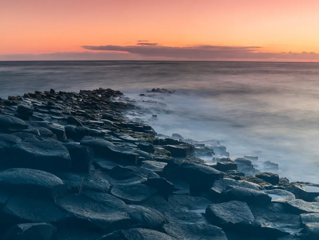
You’ve seen hexagons in honeycombs. You’ve seen them on soccer balls. But you probably haven’t seen roughly 40,000 of them rising from the sea like a staircase built for something enormous. The Giant’s Causeway in Northern Ireland consists of more than 40,000 interlocking volcanic rock pillars, most of which are hexagonal, although some have fewer or more sides. It’s one of those places where your brain keeps insisting something must have built it on purpose.
Researchers say it was created by lava traveling out of cracks in the earth 60 million years ago, which cooled over time into a honeycomb pattern, with some pillars standing as tall as 36 feet (12 meters). The most famous tale involves the Irish giant Finn McCool, who is said to have built the causeway to cross the Irish Sea and confront his Scottish rival, Benandonner. Honestly, given what you see there, the legend feels almost reasonable.
3. Antelope Canyon, Arizona – A Canyon Carved by Fury, Lit Like a Dream
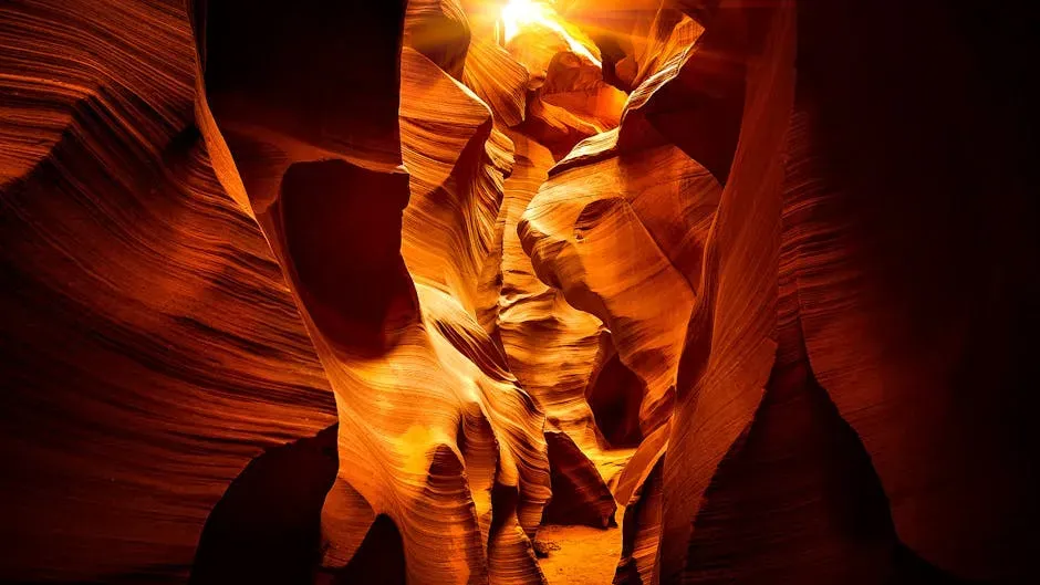
There are places that simply don’t look real in photographs. Antelope Canyon is one of them. The canyon was formed over thousands of years by the erosion of Navajo sandstone, resulting in narrow passageways with smooth, flowing walls. The interplay of light and shadows in the canyon creates a surreal and magical atmosphere. Light beams often filter through the narrow openings above, illuminating the canyon floor with a vibrant array of colors. It’s like walking inside a piece of abstract art.
Antelope Canyon was formed by the erosion of Navajo Sandstone due to flash flooding. Rainwater, especially during monsoon season, runs into the extensive basin above the slot canyon sections, picking up speed and sand as it rushes into the narrow passageways. The Navajo name for Upper Antelope Canyon, ‘Tse’ bighanilini’, means ‘the place where water runs through rocks’ – a name so perfectly chosen it feels poetic. For the Navajo people, this isn’t just a geological marvel; it’s believed that the spirit world and our world intersect at Antelope Canyon.
4. The Eye of the Sahara, Mauritania – A Bullseye Visible From Space
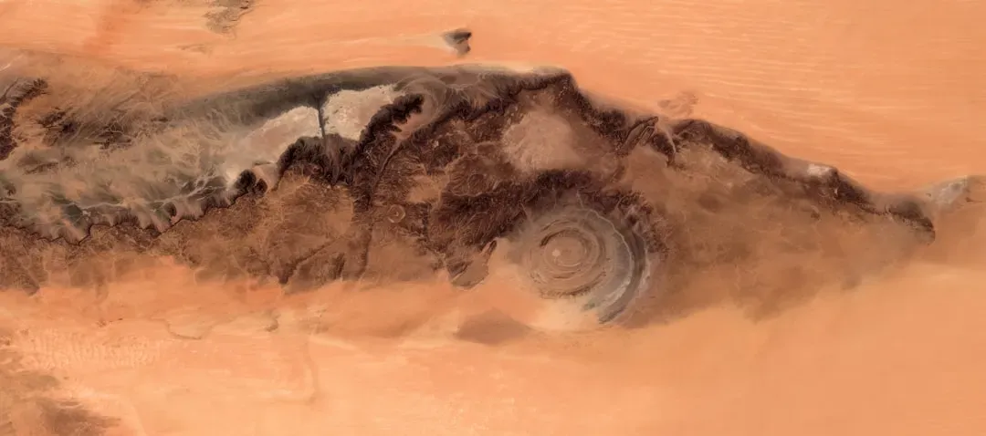
Here’s something that will genuinely unsettle you. Somewhere in the middle of the Sahara Desert, there is a structure so enormous that astronauts have used it as a landmark from orbit – and yet most people on Earth have never heard of it. The Eye of the Sahara in Mauritania, also known as the Richat Structure, resembles a bull’s-eye 30 miles (50 kilometers) wide. The mysterious formation is large enough for early space missions to have used it as a landmark.
Geologists initially thought the site was created by an asteroid impact, but there isn’t enough melted rock among the rings to support this theory. Similarly, there’s no evidence to suggest a volcanic eruption. More recently, geologists have proposed that the Eye of the Sahara could be an eroded, collapsed geological dome, formed some 100 million years ago when the supercontinent Pangea broke up. Bolstering this theory are ancient rocks found on the surface, which originated as much as 125 miles beneath the Earth’s crust and before life existed on Earth. No wonder people still argue about it.
5. Bryce Canyon’s Hoodoos, Utah – A Forest Made of Stone
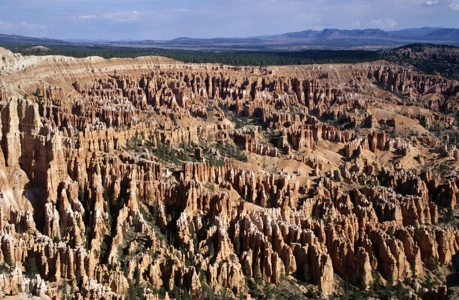
Picture thousands of thin, towering spires of red and orange rock stretching out in every direction as far as you can see. Now imagine they’re all staring at you. Bryce Canyon is home to the world’s largest hoodoo field, and standing inside it feels less like hiking and more like wandering into a civilization of silent, ancient beings. According to the Southern Paiute people, hoodoos are individuals that were transformed to stone by the trickster god Coyote, as punishment for bad deeds.
Water from rain or melted snow seeps into cracks along the crater rims and expands as it freezes overnight, before thawing again as temperatures climb. This freeze-thaw cycle is repeated until eventually the rock breaks. Slightly acidic rain falling onto the limestone and calcium carbonate also eats away at these weaker rocks, while stronger rocks remain untouched, enhancing the dramatic shapes. It’s a slow, patient kind of destruction – and the results are extraordinary. The hoodoos of Bryce Canyon are a temporary sight, eroding at an average of 60 to 130cm per century. So if you’re planning a visit, maybe don’t wait too long.
6. Pamukkale, Turkey – The Cotton Castle in the Sky
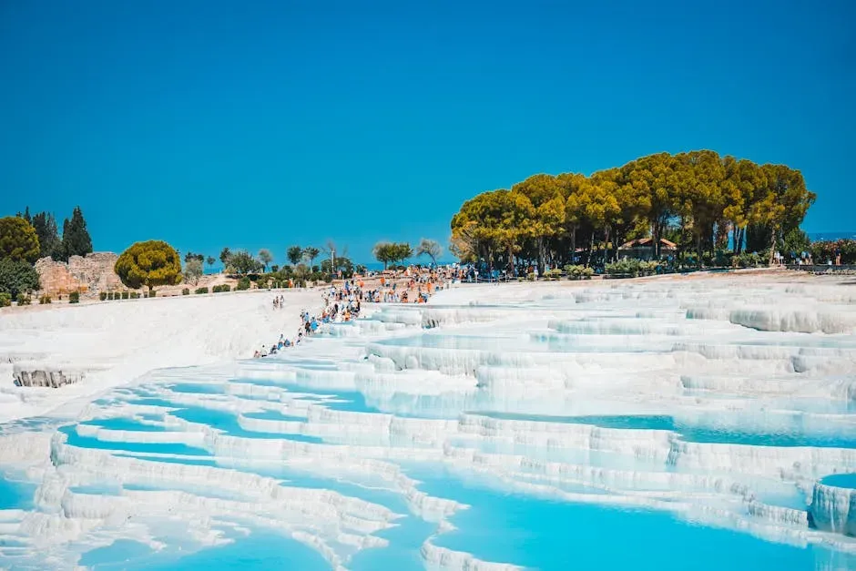
I think of Pamukkale as the place where geology decided to play architect and ended up building something that looks more like a snow resort than a natural formation. Pamukkale’s terraces look like soft, snowy steps descending down a hillside – but they’re not snow. They’re travertine, a form of limestone deposited by thermal waters that have been bubbling up here for thousands of years. The contrast of bright white stone against warm mineral pools is genuinely breathtaking.
Since the days of ancient Rome, people have sought the healing properties of these mineral-rich waters. The name Pamukkale means “Cotton Castle” in Turkish, and as you explore this UNESCO World Heritage site you’ll understand why. The ancient Greco-Roman city of Hierapolis, now in ruins nearby, was built here precisely because of these healing waters. It’s a place where geology and human history are so deeply intertwined, you can’t separate them. Standing there, you’re walking on the same stone that ancient Romans walked on to ease their aching joints – and honestly, that’s kind of magical.
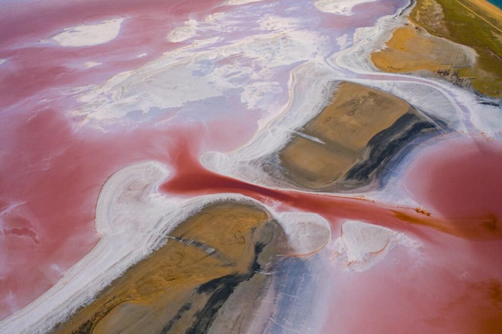
7. Salar de Uyuni, Bolivia – The World’s Biggest Mirror
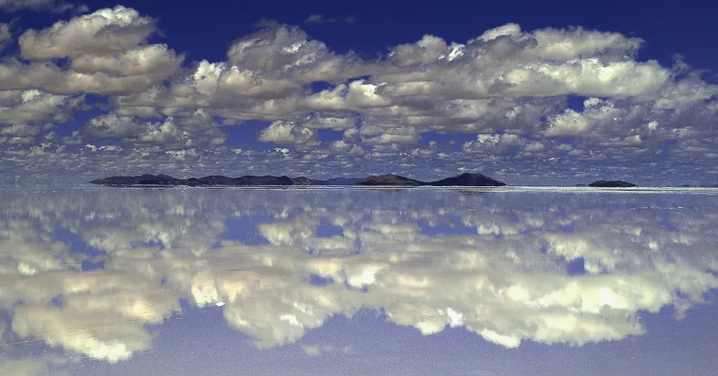
Imagine a place so flat, so impossibly white, and so vast that the line between the ground and the sky simply ceases to exist. Salar de Uyuni is what’s left of a long-evaporated prehistoric lake. What remains is over 10,000 square kilometers of pure salt – so flat you can measure satellite alignment with it, and so blindingly bright it feels like walking on another planet. No photograph fully prepares you for it.
When it rains, something magical happens: a thin layer of water turns the entire surface into a perfect mirror. Suddenly, the line between sky and land disappears. You can walk into the clouds. People take bizarre perspective photos here because the reflection messes with your depth perception in the most glorious way. The crust covers a pool of brine which is exceptionally rich in lithium, and contains somewhere between half and two-thirds of the world’s known lithium reserves. So while you’re taking selfies in the sky reflection, you’re also standing above one of the most economically valuable deposits on Earth. Strange world.
8. The Chocolate Hills, Philippines – Nature’s Strangest Joke
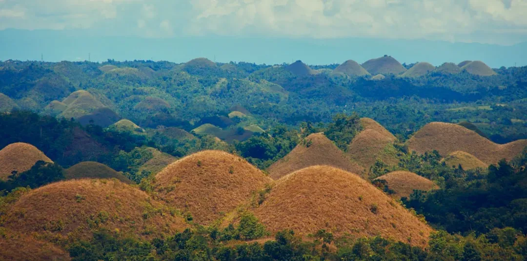
It’s hard not to smile the first time you see them. Over a thousand perfectly rounded, grass-covered mounds arranged across the island of Bohol like something dropped there from a great height. These cone-shaped hills are made of limestone and covered in lush green vegetation during the rainy season. They turn brown in the dry season, resembling rows of chocolate kisses. Hence the name – and honestly, it’s the most accurate name in all of geography.
The Chocolate Hills are a geological formation in the Bohol province of the Philippines, with at least 1,260 hills, but there may be as many as 1,776 spread over an area of more than 50 square kilometres. These limestone hills were formed by the uplift of coral deposits and the action of rainwater and erosion over millions of years. The hills are almost uniform in shape and size, creating a surreal landscape. Geologists have a working theory, but it’s hard to say for sure exactly how they ended up so eerily consistent in shape – and that mystery only adds to their charm. The Chocolate Hills are protected as a National Geological Monument, and conservation efforts have been implemented to preserve their unique appearance. Scientists continue to study the formation to understand the long-term effects of climate change on this natural wonder.
Conclusion: Earth Is the Alien Planet You Already Live On
Here’s the thing most people miss – we’re constantly looking outward, toward the stars, for something extraordinary, while our own planet quietly hosts landscapes that would look at home in a science fiction film. From the boiling acid springs of the Danakil Depression to the mirror-flat salt plains of Bolivia, Earth’s geology is more dramatic, more surreal, and more awe-inspiring than most of us ever take time to appreciate.
You don’t need to wait for a Mars mission or a trip to another solar system. The alien world is already here, shaped by billions of years of volcanic fury, tectonic drama, wind, water, and ice. These eight formations are proof that the most extraordinary journey you can take is often the one that leads you deeper into your own planet.
So, which of these formations surprised you the most – and which one are you already planning to visit?