If you’ve ever stood in front of a strange rock formation and felt your brain quietly whisper, “How on Earth…?”, then you already know the weird magic geology can have. Some landscapes feel less like the slow work of erosion and more like the set of a science-fiction movie somebody forgot to dismantle.
What makes the formations below so addictive is that even when science has a decent explanation, they still look impossible to the naked eye. They twist gravity, bend symmetry, and make us question how patient our planet must be to carve art out of stone over millions of years. Let’s walk through ten places where the Earth seems to show off a little.
The Giant’s Causeway, Northern Ireland
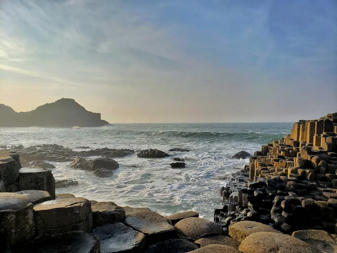
The first time I saw a photo of the Giant’s Causeway, I honestly thought it was some kind of ancient alien landing pad. Around forty thousand interlocking basalt columns, most of them neat hexagons, march out from the cliffs into the sea like a perfectly tiled pathway made for a giant. From a distance, it looks weirdly artificial, almost like someone snapped together a set of stone Lego blocks and forgot to pack them away.
The real story is both less mystical and far more impressive. Around fifty to sixty million years ago, intense volcanic activity flooded this coast with thick lava, which cooled and shrank in a surprisingly orderly way, cracking into long, geometric columns. It’s the same principle you see when mud dries and splits, just on a much larger, three-dimensional scale. Even once you know that, it’s hard not to feel a jolt of wonder standing there, watching waves crash over a pattern so precise it seems to mock our modern obsession with “perfect design.”
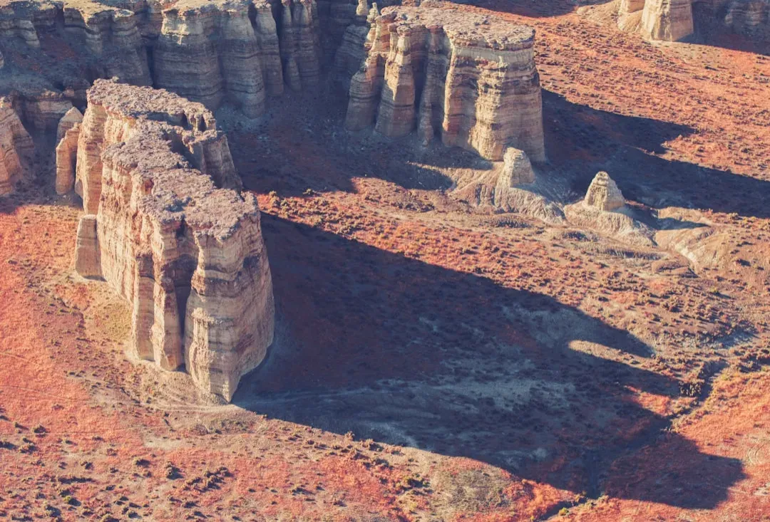
Devils Tower, Wyoming, USA
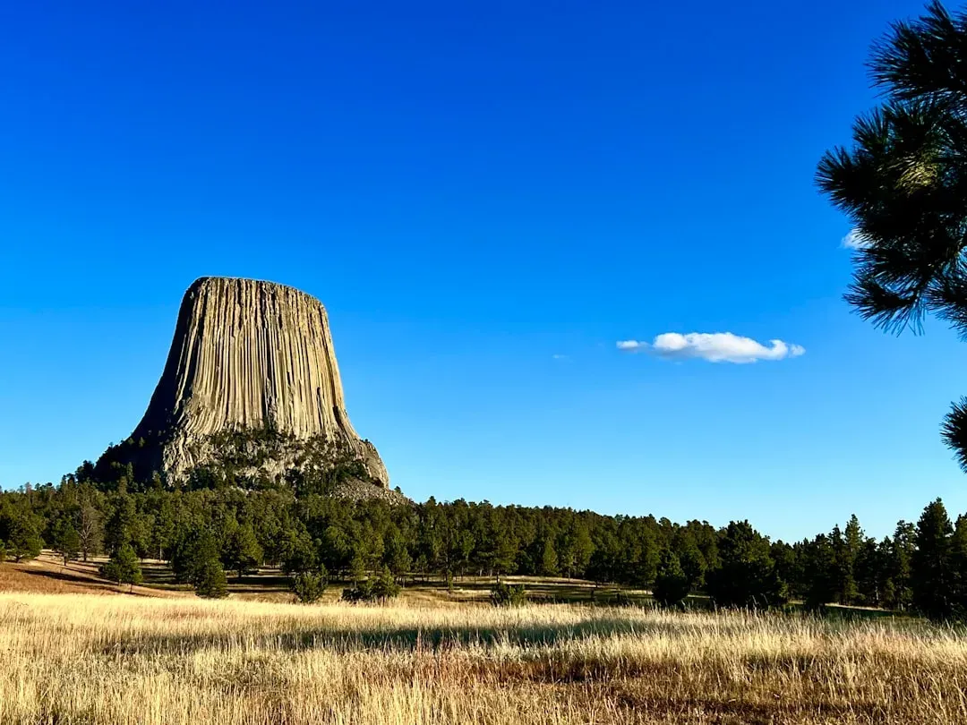
Devils Tower rises straight out of the rolling hills of Wyoming like some monolithic, vertical ship breaking through a green ocean. It’s a single, hulking pillar of rock with long, straight, fluted columns running down its sides, and if you’ve seen it in photos and thought it was exaggerated, it’s not. In person, it looks even more unreal, especially at sunset when it glows a deep, rusty orange against the sky.
Geologists broadly agree that Devils Tower is the cooled core of ancient volcanic activity, but they still argue about the exact details of how it formed. Was it a plug of magma that solidified in the throat of a volcano, or a shallow intrusion that got exposed when softer rock eroded away? Either way, what remains is an isolated tower of phonolite porphyry that rock climbers worship and many Native nations consider deeply sacred. It’s one of those places where the stark geometry of nature feels like it’s trying to say something big, even if we still don’t quite know how to read it.
The Eye of the Sahara (Richat Structure), Mauritania
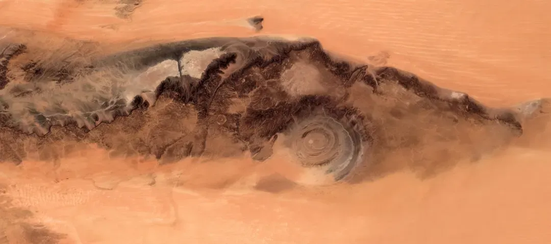
From the ground, the Eye of the Sahara is just a broad, rocky landscape that feels endless. But viewed from space, it suddenly snaps into focus as a colossal bull’s-eye, a set of nearly perfect concentric rings about forty kilometers across, etched into the middle of the desert. When astronauts first reported it, people understandably jumped to wild ideas, from massive meteor craters to ancient lost cities.
The leading explanation today is surprisingly subtle: the Richat Structure is thought to be a deeply eroded geological dome, where layers of rock were uplifted and then stripped away in rings by wind and water over tens of millions of years. Different rock types erode at different rates, carving those distinctive circular bands that look like some planetary fingerprint. Even with that understanding, its symmetry is so uncanny that it keeps showing up in conspiracy threads and speculative documentaries. Sometimes, even after a decent explanation, your eyes refuse to file what they’re seeing under “ordinary erosion.”
The Sailing Stones of Racetrack Playa, Death Valley, USA
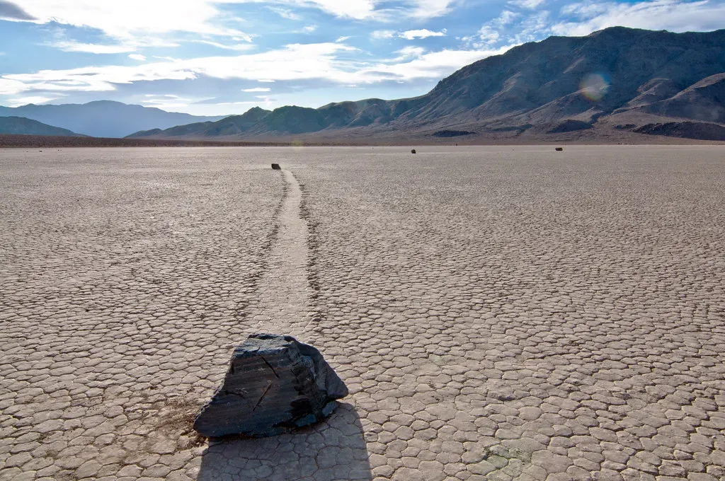
Imagine walking onto a dry, flat lakebed and finding dozens of rocks scattered across the surface, each one with a long, thin track etched behind it in the hardened mud, like they secretly slid for meters or even tens of meters across the ground. No footprints. No obvious slope. No sign of anyone dragging them. For decades, the sailing stones of Racetrack Playa in California’s Death Valley were one of the most unsettling natural mysteries in geology.
The most widely accepted explanation now is elegant and almost comically delicate. In rare winter conditions, a shallow sheet of water can freeze around the stones into thin “panels” of ice. When the ice begins to melt and winds push across the playa, these panels drift, gently nudging the rocks along, leaving tracks behind in the soft mud. Researchers even captured this on time-lapse cameras in the last decade. Still, knowing that doesn’t take away the eerie feeling of standing there on a blistering hot day, staring at a stone that appears to have slid itself across the desert floor overnight.
Pamukkale’s Terraces, Türkiye
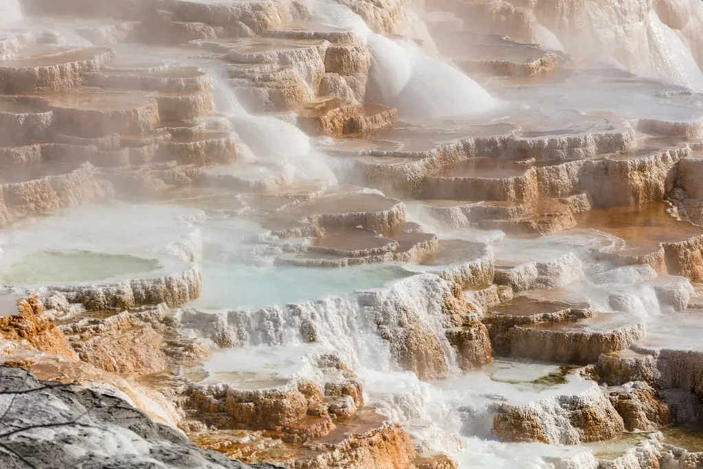
Pamukkale looks like a frozen waterfall built out of clouds. White, rounded terraces cascade down the hillside, filled with pale blue, steaming pools that look almost too perfect to be natural. When you see photos, it’s easy to mistake the place for snow or ice, but it’s actually dazzling white travertine, a form of limestone deposited by mineral-rich hot springs.
For thousands of years, thermal waters loaded with calcium carbonate have spilled over the slopes, cooling and dropping their mineral load in thin layers that gradually built the terraces. Tiny changes in flow, temperature, and bacteria growth influence the shapes that form, which is why the whole site looks like an organic sculpture that’s constantly being revised. Standing there barefoot on the warm stone feels a bit like walking across the back of some sleeping giant, with the knowledge that every millimeter under your feet took unthinkable time to form.
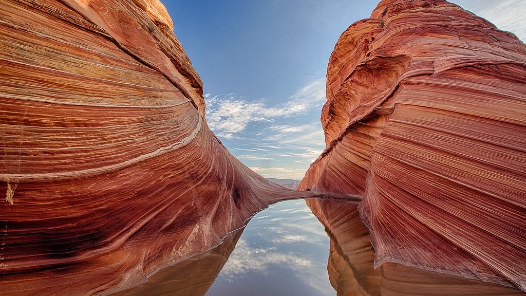
The Wave, Arizona–Utah Border, USA
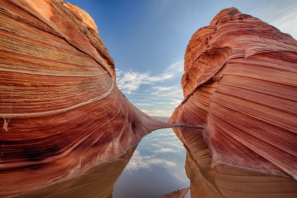
The Wave looks like someone liquefied a canyon, swirled the rock with paint, and then flash-froze it mid-motion. Long, sweeping bands of red, orange, and cream sandstone ripple across a narrow valley in northern Arizona, forming curves so smooth and continuous they can make you a little dizzy. If you’ve ever doubted that erosion could create something that looks like art on purpose, this is the place that changes your mind.
Geologically, the Wave is a masterpiece crafted from Navajo Sandstone, which started as massive ancient sand dunes roughly two hundred million years ago. Over time, mineral-rich groundwater cemented the grains, wind and water carved channels, and slightly different compositions of iron and other minerals created the contrasting colored layers. The result is a formation so fragile and heavily visited that access is strictly limited by permit. It’s a landscape that feels both intimate and alien, like walking through the preserved memory of a long-vanished desert.
The Stone Forest (Shilin), China
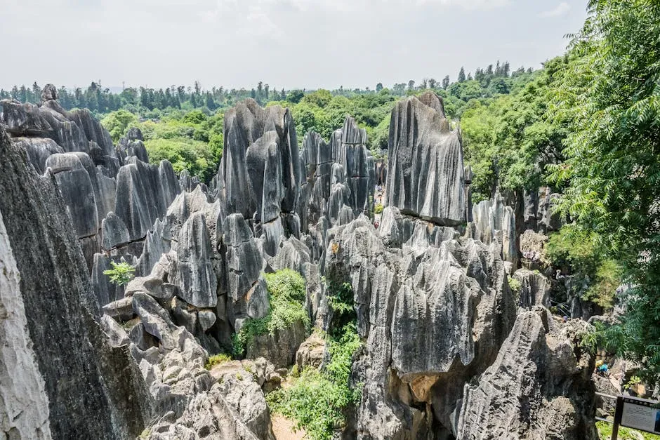
At Shilin in Yunnan Province, “forest” doesn’t mean trees, it means stone. Jagged, narrow limestone pinnacles crowd together, some taller than a ten-story building, creating the illusion of a petrified woodland frozen mid-gale. Wander through it and you pass under arches, around spires, and along narrow corridors that feel almost like city streets, except the “buildings” are sharp gray rock.
This stone labyrinth started as a thick layer of limestone laid down in an ancient sea, later uplifted and slowly dissolved by rainwater over millions of years. The chemistry is straightforward: slightly acidic water seeps into cracks and joints, dissolving the rock and leaving behind resistant pillars and towers. What makes Shilin so unsettling is the sheer density and vertical exaggeration of those towers, which combine into something that feels more like a giant coral reef exposed to the air than a land-based formation. It’s easy to see why local legends tend to lean toward spirits and transformation when describing it.
Socotra’s Dragon’s Blood Trees and Alien Scenery, Yemen
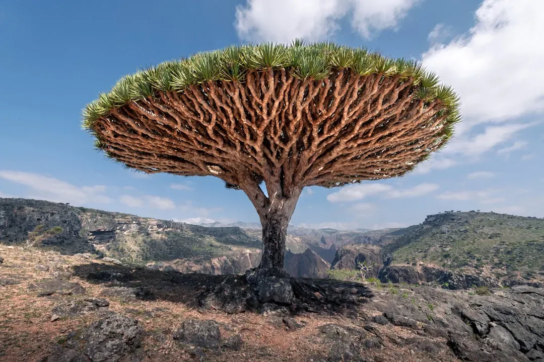
Technically, Socotra’s strangeness is as much biological as geological, but the island’s rock and tree shapes are so intertwined that it’s impossible to separate them. Perched on rugged limestone plateaus and wind-scoured ridges are dragon’s blood trees, with umbrella-shaped canopies and thick, gnarled trunks that look like they were designed for a fantasy video game. Combined with eroded karst formations and bare, wind-etched cliffs, the whole island feels like a set piece transported from another planet.
Socotra sits on a fragment of continental crust in the Arabian Sea, and its isolation, combined with harsh, dry conditions, carved both the rocks and the life that clings to them into unique forms. The dragon’s blood tree evolved its odd shape partly to shade its own roots and limit water loss, while the limestone beneath it has been sculpted into sinkholes, caves, and sharp ridges. The result is a landscape where geology and biology have been co-writing the same surreal script for millions of years. Standing on a Socotran cliff, with the sea below and these strange silhouettes around you, it’s very easy to forget you’re still on Earth.
Fingal’s Cave, Scotland
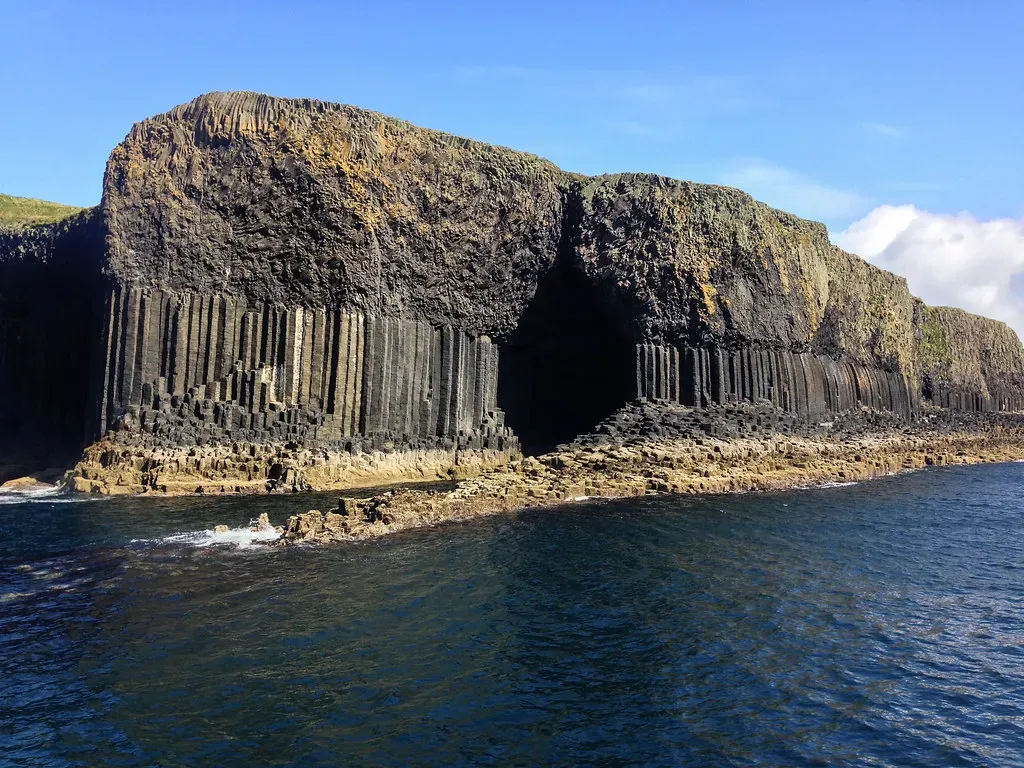
On the uninhabited Scottish island of Staffa, the Atlantic has carved a vast sea cave straight into perfectly hexagonal basalt columns, creating something that looks like an underground cathedral made of black stone. Fingal’s Cave has a high, arched ceiling, vertical walls of geometric pillars, and a natural walkway that lets you step inside when conditions allow. Waves crash and echo in a way that feels theatrical, as if the architecture was designed for sound.
The same kind of cooling and cracking that formed the Giant’s Causeway also shaped the basalt columns here, but the sea did something extra: it selectively eroded weaker parts of the cliff, hollowing out a chamber while leaving the neat column walls intact. The overall symmetry is so convincing that early visitors struggled to believe it was fully natural. Even now, knowing the slow mechanics of volcanic rock and relentless wave action, the cave hits you emotionally first and logically second, which might be the most satisfying order for an encounter with deep time.
Spotted Lake, British Columbia, Canada
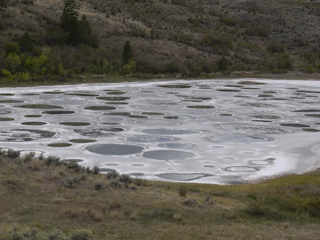
Spotted Lake in Canada looks normal enough for much of the year, but in the dry season it transforms into something that seems almost cartoonish from above. The water level drops, and what remains is a series of dozens of circular or oval “spots” in different colors, separated by thin mineral ridges, like a painter’s palette left in the sun. Each pool has a slightly different hue, from turquoise to yellow to soft green, depending on the minerals concentrated there.
This effect comes from extremely mineral-rich water, loaded with magnesium sulfate, calcium, and other salts, that slowly evaporates in the summer heat. Different salts crystallize at different rates and concentrations, forming separated basins with varied colors and textures. For local Indigenous communities, the lake has long held cultural and spiritual significance, which makes a lot of sense once you’ve seen it. You can understand all the chemistry in the world and still feel that chill of recognition that some places seem designed specifically to make us stop, stare, and wonder when the Earth decided to get so weird.
Conclusion
These formations stretch from icy caves to burning deserts, but they all share one uncomfortable talent: they expose just how limited our everyday sense of time and change really is. We’re used to thinking in days or years; these places were carved in slow-motion over millions of cycles of heating, freezing, dissolving, erupting, and eroding. When you finally stand in front of them, the usual mental shortcuts we use for “how things are made” simply stop working.
Maybe that’s the real reason they feel so mind-bending. They’re reminders that the planet is quietly sculpting, testing, and revising itself whether we’re paying attention or not. Next time you see a strange rock or an oddly shaped cliff, it might be part of some vast, half-finished artwork still in progress. Which one of these places would you most want to stand in and see with your own eyes?